Kouaoua
From CruisersWiki
Istioploos (Talk | contribs) m (Reverted edits by Riley Huntley (talk) to last revision by Peter McHugh) |
Peter McHugh (Talk | contribs) |
||
| Line 73: | Line 73: | ||
====Anchorages==== | ====Anchorages==== | ||
| + | Kouaoua Anchorage Sketch.jpg | ||
| + | [[Image:Kouaoua Anchorage Sketch.jpg|350px|thumb|right|'''Kouaoua Anchorage '''<br/>''Click for larger view'']] | ||
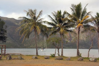
[[Image:Kouaoua_Dinghy_Landing.jpg|350px|thumb|right|'''Dinghy landing at Kouaoua '''<br/>''Click for larger view'']] | [[Image:Kouaoua_Dinghy_Landing.jpg|350px|thumb|right|'''Dinghy landing at Kouaoua '''<br/>''Click for larger view'']] | ||
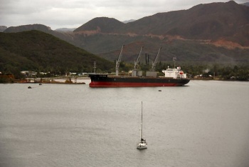
[[Image:Jules_Garnier.jpg|350px|thumb|right|'''Jules Garnier taking on ore at Kouaoua '''<br/>''Click for larger view'']] | [[Image:Jules_Garnier.jpg|350px|thumb|right|'''Jules Garnier taking on ore at Kouaoua '''<br/>''Click for larger view'']] | ||
Revision as of 09:27, 11 March 2013
Kouaoua, New Caledonia
| | |
| | DD°M.M′N/S, DD°M.M′E/W |
|---|---|
| | Photo gallery |
| | Local chartlet |
Overview
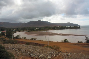
Kouaoua is a small mining town (pop.1500) on the east coast of New Caledonia. Facilities are limited, but there is one small store, water is available on the waterfront and the anchorage is secure. Fuel may be available at a small petrol station. There is an active local market on Tuesdays and Thursdays run by the local ladies. It offers good produce and they are both friendly and welcoming.
Cruising the region
Baie de Kouaoua is large and sheltered, but mostly taken up with with two large nickel mining operations. Baie Laugier, about a mile to the east is definitely more scenic, but there are no facilities and the holding in the anchorage seems a little doubtful.
Heading north, the next sheltered anchorage is Ugue, about 22nm away.
Heading south, it is about 10 nm to Baie de Canala, a very deep bay with a choice of several anchorages. To reach Canala it is necessary to round Cap Begat, after which it is a clear run down the very long Baie de Canala.
Local Weather
Local weather conditions?
Sources for Weather forecasts:
Local forecasts are, of course, in French, but non-French speakers should find them relatively easy to understand. A very useful vocabulary can be found at How to Understand French Weather Forecasts for Sailors.
The main source of weather information for the area around New Caledonia is Meteo France Nouvelle-Calédonie. The marine section provides a 6 day forecast for the whole region, with details for each of the passes through the barrier reef.
Nouméa radio broadcasts the weather report in French on VHF 16, everyday at 6:30, 9:30, 15:15, 18:30.
There is a set of repeater channels allowing receipt of weather info anywhere in the country:
- Nouméa area: VHF 26
- Southern portion of the Grande Terre: VHF 28
- Isle of Pines and the Southern Lagoon: VHF 25
- Grande Terre North West coast: VHF 25
- Northern portion of Grande Terre: VHF 24
- Ouvea: VHF 23
- Lifou: VHF 26
- Maré: VHF 87
Charts
Submit the chart details that are required for safe navigation.
- Chart Source
- Chart No
- Chart No
Radio Nets
Also see World Cruiser's Nets
Because of the commercial nature of Kouaoua, nearby dangers are well marked. Passe de Kouaoua and Passe de Canala both provide good access from seaward. Passe de Kouaoua is over 1/2 a mile wide and very deep, so it should provide good access in most conditions. Note that there is a substantial area of coral about 1 1/2 nm north of the mouth of Baie de Kouaoua. There is a green marker denoting the southern edge of this reef and this is lit (Gp Fl 2 6 sec).
Check-in facilities (for Customs and Immigration)
You must check in with customs in Noumea before proceeding elsewhere in New Caledonia.
Offshore Islands and Groups
List Islands
Marinas & Yacht Clubs
- None
Anchorages
Kouaoua Anchorage Sketch.jpg
- The most useful anchorage is just north of the ore loading facility. The anchorage is inshore from the northern most mooring bouys that are used to hold ships in position at the loader. Safe dinghy landing can be had on the beach behind the anchorage. There is water from taps on the shore. A foot bridge over a tidal stream provides access to the town. Ensure that you anchor well clear of the mooring bouys as this is a very active port and ships may berth at any time. Needless to say, the loading process is not quiet.
In common with many of the anchorages in the mining areas of New Caledonia, the bottom is thick red mud. Try to wash it off before you get it on your deck as it stains.
- Anchorage can be found on the eastern side of the bay, away from the town and the loading facility, but the holding here is not as secure as it is near the town. The bottom appears to be rock under a thin layer of mud.
- Bear in mind that there is considerable maritime traffic associated with ore loading. This includes tugs, barges and other small vessels. Show good anchor lights.
Yacht Repairs and Services
Marine Stores
Submit addresses and contact details of marine related businesses that are of interest to cruisers.
- None
Repairs/Yards
- None
Fuel, Water, & Electricity
- Fuel
- There seems to be a fuel station which may be able to provide diesel and gas (French bottles only)
- Water
- There are taps on the beach immediately inshore of the prime anchorage.
- Electricity
- Nothing accessible
Things to do Ashore
Tourism
List places of interest, tours, etc.
- The huge ore conveyor is noted as a tourist attraction. Known as La Serpentine, it is 12 km long.
Grocery & Supply Stores
- There is a single well stocked grocery store.
- The local market is small, but has good fresh food. Market days are Tuesday and Thursday.
Eateries
- None
Internet/WiFi
Available?
Laundry
- None
Motorbike & Car Rentals
- Probably not.
Garbage Disposal
There are rubbish bins on the waterfront near the anchorage.
Transportation
Transportation (local and/or international)
Routes/Passages To/From
Popular passages/routes, timing, etc.
Cruiser's Friends
Contact details of "Cruiser's Friends" that can be contacted for local information or assistance.
Forum Discussions
List links to discussion threads on partnering forums. (see link for requirements)
External Links
Links to relevant websites.
References & Publications
Publications, Guides, etc.
Personal Notes
Personal experiences?
Last Visited & Details Checked (and updated here)
Date of member's visit to this Port/Stop & this page's details validated:
- July 2010 - Pedro
|
|---|
|
Names: Pedro |
| |
|---|
| | HOMEPAGE | Wiki Contents | South Pacific | New Caledonia | Kouaoua | |


