Lampedusa
From CruisersWiki
Lighthouse (Talk | contribs) m (Text replace - "Mediterranean" to "Mediterranean") |
m (Text replace - "==References & Publications==" to "==References==") |
||
| (33 intermediate revisions not shown) | |||
| Line 1: | Line 1: | ||
| - | + | {{IsPartOf|Mediterranean|Italy|Sicily}} | |
| - | {| | + | {{TOC block}} |
| - | | | + | |
| - | + | {{Infobox | |
| - | + | | lat= 35.51517| lon=12.58167 | |
| - | | | + | | name= Lampedusa |
| - | + | | portofentry= | |
| - | + | | containsportofentry= | |
| - | + | | zoom= 12 | |
| - | + | | chartlet = y | |
| + | | image= Lampedusa5.jpg | ||
| + | | imagetext= Lampedusa Island | ||
| + | | summary= | ||
| + | | notes= | ||
| + | | news= | ||
| + | }} | ||
| - | |||
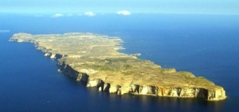
The Mediterranean island of Lampedusa (Italian: ''Isola di Lampedusa''; Sicilian: ''Isula di Lampidusa'') belongs to Italy and is the largest of the Pelagie Islands, situated 111 nM (205 km) from [[Sicily]], 90 nM (167 km) from [[Malta]], and 63 nM (113 km) from [[Tunisia]]. The Lampedusa has an area of 20 km<sup>2</sup> and a population of 5,300. Its population subsists on fishing, agriculture and tourism. It is a major holding area for Africans immigrating to Europe (being that there is a Italian Military base on the Island with detention facilities). | The Mediterranean island of Lampedusa (Italian: ''Isola di Lampedusa''; Sicilian: ''Isula di Lampidusa'') belongs to Italy and is the largest of the Pelagie Islands, situated 111 nM (205 km) from [[Sicily]], 90 nM (167 km) from [[Malta]], and 63 nM (113 km) from [[Tunisia]]. The Lampedusa has an area of 20 km<sup>2</sup> and a population of 5,300. Its population subsists on fishing, agriculture and tourism. It is a major holding area for Africans immigrating to Europe (being that there is a Italian Military base on the Island with detention facilities). | ||
Lampedusa is the largest part of the comune of ''Lampedusa e Linosa'' which also includes the smaller islands of Linosa and Lampione with the former being inhabited, but the latter just hosting an automatic lighthouse. | Lampedusa is the largest part of the comune of ''Lampedusa e Linosa'' which also includes the smaller islands of Linosa and Lampione with the former being inhabited, but the latter just hosting an automatic lighthouse. | ||
| - | + | ==Charts== | |
| - | + | ; BA | |
| - | + | : 176 - Cap Bon to Ra's At Tin | |
| + | : 193 - Sicily: Islands in the Sicilian Channel | ||
| + | ; NIMA | ||
| + | : 53220 - Strait of Sicily-Southern Reaches | ||
| + | : 52170 - Rass el Melah to Sfax | ||
| + | |||
| + | ==Weather== | ||
| + | See [[Italy#Weather|Italy]]. | ||
| + | |||
| + | ==Passages== | ||
| + | ''See [[Aegean_to_West_Mediterranean_Passages|Aegean to West Mediterranean Passages]].'' | ||
| + | |||
| + | ==Islands== | ||
| + | * [[Pantelleria]] | ||
| + | |||
| + | ==Communication== | ||
| + | {{Green|Add here VHF channel for coastguard, harbor masters. etc.}} | ||
| + | * | ||
* | * | ||
| - | |||
| - | |||
| - | + | ''Also see [[World MM Nets|World Cruiser's Nets]]'' | |
| - | ''Also see [[ | + | |
| - | + | ==Navigation== | |
| + | {{Green|Add any navigation notes such approaches, dangers etc here. If this section does not apply remove it.}} | ||
| - | === | + | ==Berthing== |
| - | + | ===Ports=== | |
| + | [[Image:Lampedusa_Panorama.jpg|frame|center|Lampedusa Port]] | ||
| + | {{poi | lat= 35.49738 |lon=12.60334 | ||
| + | | type= harbour | ||
| + | | name= Lampedusa Port | ||
| + | | altname= | ||
| + | | zoom= 15 | ||
| + | | portofentry= | ||
| + | | image= Italy_Lampedusa_h.jpg | ||
| + | | imagetext= Chart of Lampedusa Harbor | ||
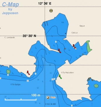
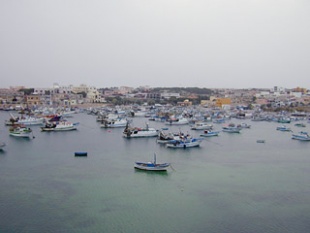
| + | | text= Lampedusa has a small harbor full of fishing boats and even in early May it is hard to find a place for your yacht. You may find room to go side-to on the E side of the harbor but watch the depth because it can be shallow (< 2.0 metres). | ||
| + | }} | ||
| - | + | {{Image right| Italy_Lampedusa1.jpg|310px| The busy harbor of Lampedusa}} | |
| - | + | ||
| - | + | ||
| - | + | ===Marinas & Yacht Clubs=== | |
| + | None. | ||
| - | === | + | ==Anchorages== |
| - | + | {{poi | lat= 35.49819| lon=12.60076 | |
| + | | type= anchorage | ||
| + | | name=Cala Guitgia | ||
| + | | altname= | ||
| + | | zoom= 16 | ||
| + | | image= | ||
| + | | imagetext= | ||
| + | | text= Can anchor in the left bay when entering the main port. There is a very nice beach, as well as bars and restaurants. | ||
| + | }} | ||
| - | === | + | ==Amenities== |
| - | + | {{tlist | |
| - | + | ||
| - | + | |header|Facilities | |
| - | + | ||
| - | + | ||
| - | + | ||
| - | + | |Water| N/A (Not Available) | |
| - | + | |Electricity| N/A | |
| - | + | |Toilets| {{MagentaText|?}} | |
| + | |Showers| {{MagentaText|?}} | ||
| + | |Laundry| {{MagentaText|?}} | ||
| + | |Garbage| There are bins around the harbors and in several anchorages | ||
| - | + | |header|Supplies | |
| - | + | |Fuel| From fuel stations, you will have to carry jerry cans | |
| - | + | |Bottled gas| {{MagentaText|?}} | |
| + | |Chandlers| None | ||
| - | + | |header|Services | |
| - | + | |Repairs| N/A | |
| - | + | |Internet| {{MagentaText|?}} | |
| + | |Mobile connectivity| {{MagentaText|?}} | ||
| + | |Vehicle rentals| {{MagentaText|?}} | ||
| + | }} | ||
| - | == | + | ==Provisioning== |
| - | + | Few modest stores in the village. | |
| - | == | + | ==Eating out== |
| - | + | Good sea food in several restaurants. | |
| - | + | ||
| - | + | ||
| - | + | ||
| - | + | ||
| - | + | ==Transportation== | |
There are daily ferries and flights (in the summer) to [[Sicily]]. | There are daily ferries and flights (in the summer) to [[Sicily]]. | ||
| - | == | + | ==Tourism== |
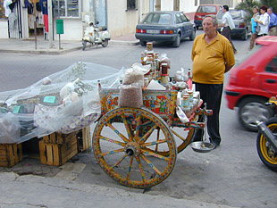
| - | + | [[Image:Italy_Lampedusa2.jpg|frame|right|Old fashioned street vendor in Lampedusa]] | |
| - | == | + | There is not much to see but the village is fun to walk around. Also, one can take some lovely hikes around the island. |
| + | |||
| + | ==Friends== | ||
Contact details of "Cruiser's Friends" that can be contacted for local information or assistance. | Contact details of "Cruiser's Friends" that can be contacted for local information or assistance. | ||
| - | == | + | ==Forums== |
| - | List links to discussion threads on [[Cruising Forums|partnering forums]]. (see link for requirements) | + | List links to discussion threads on [[Cruising Forums|partnering forums]]. (''see link for requirements'') |
* [http://www.cruiserlog.com/forums/index.php?showtopic=7988 Wintering in Lampedusa?] | * [http://www.cruiserlog.com/forums/index.php?showtopic=7988 Wintering in Lampedusa?] | ||
* | * | ||
| - | |||
| - | == | + | ==Links== |
| + | * {{wikipedia}} | ||
| + | * {{Wikivoyage|Pelagie Islands|Pelagie Islands}} | ||
* [http://lampedusainfo.it/129-English_Version.html Lampedusa] | * [http://lampedusainfo.it/129-English_Version.html Lampedusa] | ||
* | * | ||
| - | |||
| - | === | + | ==References== |
| - | + | ''See [[Italy#References_&_Publications|Italy]]''. | |
| - | + | ||
| - | + | {{Comments}} | |
| - | + | ||
| - | + | ||
* | * | ||
| + | {{Verified by}} | ||
| + | * May 2001 --[[User:Istioploos|Istioploos]] [[Image:Greece_Icon.png]] [[File:Sailboat_favicon.png]] [http://www.sy-thetis.org Travels with S/Y Thetis] 14:28, 15 July 2008 (MDT) | ||
| + | * June 2016 {{User:Stefvero}} | ||
| + | |||
| + | |||
| + | {{Page useable}} | ||
| - | |||
| + | {{Contributors|[[User:Lighthouse|Lighthouse]], [[User:Istioploos|Istioploos]], [[User:Chiroeurope|Chiroeurope]]}} | ||
| - | + | [[Category:Islands - Italy]] [[Category:Ports - Italy]] | |
| - | + | ||
| - | + | ||
| - | + | ||
| - | + | ||
| - | + | ||
| - | + | ||
Latest revision as of 12:00, 15 August 2018
| Lampedusa
| |
| | |
The Mediterranean island of Lampedusa (Italian: Isola di Lampedusa; Sicilian: Isula di Lampidusa) belongs to Italy and is the largest of the Pelagie Islands, situated 111 nM (205 km) from Sicily, 90 nM (167 km) from Malta, and 63 nM (113 km) from Tunisia. The Lampedusa has an area of 20 km2 and a population of 5,300. Its population subsists on fishing, agriculture and tourism. It is a major holding area for Africans immigrating to Europe (being that there is a Italian Military base on the Island with detention facilities).
Lampedusa is the largest part of the comune of Lampedusa e Linosa which also includes the smaller islands of Linosa and Lampione with the former being inhabited, but the latter just hosting an automatic lighthouse.
Charts
- BA
- 176 - Cap Bon to Ra's At Tin
- 193 - Sicily: Islands in the Sicilian Channel
- NIMA
- 53220 - Strait of Sicily-Southern Reaches
- 52170 - Rass el Melah to Sfax
Weather
See Italy.
Passages
See Aegean to West Mediterranean Passages.
Islands
Communication
Add here VHF channel for coastguard, harbor masters. etc.
Also see World Cruiser's Nets
Add any navigation notes such approaches, dangers etc here. If this section does not apply remove it.
Berthing
Ports
Lampedusa Port
Marinas & Yacht Clubs
None.
Anchorages
Cala Guitgia
Amenities
| Facilities | |
|---|---|
| Water | N/A (Not Available) |
| Electricity | N/A |
| Toilets | ? |
| Showers | ? |
| Laundry | ? |
| Garbage | There are bins around the harbors and in several anchorages |
| Supplies | |
| Fuel | From fuel stations, you will have to carry jerry cans |
| Bottled gas | ? |
| Chandlers | None |
| Services | |
| Repairs | N/A |
| Internet | ? |
| Mobile connectivity | ? |
| Vehicle rentals | ? |
Provisioning
Few modest stores in the village.
Eating out
Good sea food in several restaurants.
Transportation
There are daily ferries and flights (in the summer) to Sicily.
Tourism
There is not much to see but the village is fun to walk around. Also, one can take some lovely hikes around the island.
Friends
Contact details of "Cruiser's Friends" that can be contacted for local information or assistance.
Forums
List links to discussion threads on partnering forums. (see link for requirements)
Links
- Lampedusa at the Wikipedia
- Pelagie Islands at the Wikivoyage
- Lampedusa
References
See Italy.
Comments
We welcome users' contributions to the Wiki. Please click on Comments to view other users' comments, add your own personal experiences or recommend any changes to this page following your visit.
Verified by
Date of member's last visit to Lampedusa and this page's details validated:
- May 2001 --Istioploos

 Travels with S/Y Thetis 14:28, 15 July 2008 (MDT)
- June 2016 -- Stephane & Veronique

 Esploristo
| This is a usable page of the cruising guide. However, please contribute if you can to help it grow further. Click on Comments to add your personal notes on this page or to discuss its contents. Alternatively, if you feel confident to edit the page, click on the edit tab at the top and enter your changes directly. |
| |
|---|
|
Names: Lighthouse, Istioploos, Chiroeurope |


