Lampedusa
From CruisersWiki
Lighthouse (Talk | contribs) (→External Links) |
Istioploos (Talk | contribs) |
||
| Line 1: | Line 1: | ||
==Lampedusa== | ==Lampedusa== | ||
| - | [[Image:Lampedusa_Panorama.jpg|frame|center|Lampedusa Port - | + | [[Image:Lampedusa_Panorama.jpg|frame|center|Lampedusa Port - 35° 29.9' N, 12° 36.4' E]] |
[[Image:Pelagie_Islands_map.png|frame|right|Pelagie Islands]] | [[Image:Pelagie_Islands_map.png|frame|right|Pelagie Islands]] | ||
| - | |||
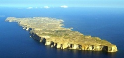
[[Image:Lampedusa5.jpg|thumb|250px|right|Lampedusa Island]] | [[Image:Lampedusa5.jpg|thumb|250px|right|Lampedusa Island]] | ||
===Background=== | ===Background=== | ||
| - | The Mediterranean island of Lampedusa (Italian: ''Isola di Lampedusa''; Sicilian: ''Isula di Lampidusa'') belongs to Italy and is the largest of the Pelagie Islands, situated 205 km from Sicily and 113 km from Tunisia. Its population subsists on fishing, agriculture and tourism. It is a major route for Africans immigrating to Europe. | + | The Mediterranean island of Lampedusa (Italian: ''Isola di Lampedusa''; Sicilian: ''Isula di Lampidusa'') belongs to Italy and is the largest of the Pelagie Islands, situated 111 nM (205 km) from [[Sicily]], 90 nM (167 km) from [[Malta]], and 63 nM (113 km) from [[Tunisia]]. The Lampedusa has an area of 20 km<sup>2</sup> and a population of 5,300. Its population subsists on fishing, agriculture and tourism. It is a major route for Africans immigrating to Europe. |
| - | Lampedusa is the largest part of the comune of Lampedusa e Linosa which also includes the smaller islands of Linosa and Lampione with the former being inhabited, but the latter just hosting an automatic lighthouse | + | Lampedusa is the largest part of the comune of ''Lampedusa e Linosa'' which also includes the smaller islands of Linosa and Lampione with the former being inhabited, but the latter just hosting an automatic lighthouse. |
| - | + | ||
| - | + | ||
===Charts=== | ===Charts=== | ||
| - | + | * BA 176 Cap Bon to Ra's At Tin | |
| + | * BA 193 Sicily: Islands in the Sicilian Channel | ||
| + | * | ||
| + | * NIMA 53220 Strait of Sicily-Southern Reaches | ||
| + | * NIMA 52170 Rass el Melah to Sfax | ||
===Radio Nets=== | ===Radio Nets=== | ||
| Line 22: | Line 23: | ||
===Approach and Navigation=== | ===Approach and Navigation=== | ||
Details? | Details? | ||
| - | |||
| - | |||
| - | |||
===Ports and Popular Stops=== | ===Ports and Popular Stops=== | ||
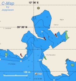
| - | + | [[Image:Italy_Lampedusa_h.jpg|thumb|250px|right|Chart of Lampedusa Harbor<br/>''Click for larger view'']] | |
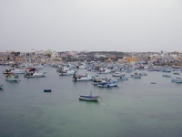
| - | + | Lampedusa has a small harbor [35° 29.9' N 12° 36.4' E] full of fishing boats and even in early May it is hard to find a place for your yacht. You may find room to go side-to on the E side of the harbor but watch the depth because it can be shallow (< 2 m). | |
| - | + | ||
| - | + | [[Image:Italy_Lampedusa1.jpg|thumb|200px|center|The busy Harbor of Lampedusa<br/>''Click for larger view'']] | |
| - | + | ||
| - | + | ||
| - | + | ||
| - | + | ||
| - | + | ||
| - | + | ||
| - | + | ||
| - | + | ||
| - | + | ||
| - | + | ||
| - | + | ||
| - | + | ||
| - | + | ||
| - | + | ||
| - | + | ||
===Routes/Passages To/From=== | ===Routes/Passages To/From=== | ||
| Line 52: | Line 34: | ||
===Tourism & things to do ashore=== | ===Tourism & things to do ashore=== | ||
| - | + | [[Image:Italy_Lampedusa2.jpg|thumb|200px|right|Old Fashioned Street Venter in Lampedusa<br/>''Click for larger view'']] | |
| + | There is not much to see but the village is fun to walk around. Also, one can take some lovely hikes around the island. | ||
===Fuel, Water, & Electricity=== | ===Fuel, Water, & Electricity=== | ||
| - | * | + | * Fuel - From fuel stations, you will have to carry jerry cans |
| + | * Water - N/A | ||
| + | * Electricity - N/A | ||
===Laundry=== | ===Laundry=== | ||
| Line 62: | Line 47: | ||
===Grocery Stores=== | ===Grocery Stores=== | ||
| - | * | + | * Few modest stores in the village |
* | * | ||
===Eateries=== | ===Eateries=== | ||
| - | * | + | * Good sea food in several restaurants |
* | * | ||
| Line 80: | Line 65: | ||
===Transportation=== | ===Transportation=== | ||
| - | + | There are daily ferries and flights (in the summer) to [[Sicily]]. | |
| - | + | ||
===References & Publications=== | ===References & Publications=== | ||
| - | + | See [[Italy#References_&_Publications|Italy]]. | |
| - | + | ||
| - | + | ||
| - | + | ||
===Cruiser's Friends=== | ===Cruiser's Friends=== | ||
| Line 105: | Line 86: | ||
===Personal Notes=== | ===Personal Notes=== | ||
Personal experiences? | Personal experiences? | ||
| + | * | ||
| + | |||
| + | ====''Last Visited & Details Checked (and updated here)''==== | ||
| + | ''Date of member's visit to this Port/Stop & this page's details validated'': | ||
| + | * May 2001 --[[User:Istioploos|Istioploos]] 14:28, 15 July 2008 (MDT) | ||
* | * | ||
Revision as of 20:28, 15 July 2008
Lampedusa
Background
The Mediterranean island of Lampedusa (Italian: Isola di Lampedusa; Sicilian: Isula di Lampidusa) belongs to Italy and is the largest of the Pelagie Islands, situated 111 nM (205 km) from Sicily, 90 nM (167 km) from Malta, and 63 nM (113 km) from Tunisia. The Lampedusa has an area of 20 km2 and a population of 5,300. Its population subsists on fishing, agriculture and tourism. It is a major route for Africans immigrating to Europe.
Lampedusa is the largest part of the comune of Lampedusa e Linosa which also includes the smaller islands of Linosa and Lampione with the former being inhabited, but the latter just hosting an automatic lighthouse.
Charts
- BA 176 Cap Bon to Ra's At Tin
- BA 193 Sicily: Islands in the Sicilian Channel
- NIMA 53220 Strait of Sicily-Southern Reaches
- NIMA 52170 Rass el Melah to Sfax
Radio Nets
Also see Cruiser's Nets
Submit details of local radio Nets.
Details?
Ports and Popular Stops
Lampedusa has a small harbor [35° 29.9' N 12° 36.4' E] full of fishing boats and even in early May it is hard to find a place for your yacht. You may find room to go side-to on the E side of the harbor but watch the depth because it can be shallow (< 2 m).
Routes/Passages To/From
Popular passages/routes, timing, etc.
Tourism & things to do ashore
There is not much to see but the village is fun to walk around. Also, one can take some lovely hikes around the island.
Fuel, Water, & Electricity
- Fuel - From fuel stations, you will have to carry jerry cans
- Water - N/A
- Electricity - N/A
Laundry
Grocery Stores
- Few modest stores in the village
Eateries
- Good sea food in several restaurants
Motorbike & Car Rentals
Marine Stores & Facilities
Submit addresses and contact details of marine related businesses that are of interest to cruisers.
Repairs
Transportation
There are daily ferries and flights (in the summer) to Sicily.
References & Publications
See Italy.
Cruiser's Friends
Contact details of "Cruiser's Friends" that can be contacted for local information or assistance.
Forum Discussions
List links to discussion threads on the Cruiser Log Forum
External Links
Personal Notes
Personal experiences?
Last Visited & Details Checked (and updated here)
Date of member's visit to this Port/Stop & this page's details validated:
- May 2001 --Istioploos 14:28, 15 July 2008 (MDT)
.


