Luka Muna
From CruisersWiki
m (Bot: Automated text replacement (-({{IsPartOf\|Mediterranean\|Adriatic Sea\|Croatia\|)(?!Northern) +\1Northern Dalmatia|)) |
Istioploos (Talk | contribs) (Template) |
||
| Line 1: | Line 1: | ||
| - | {{IsPartOf|Mediterranean|Adriatic Sea|Croatia|Northern Dalmatia| | + | {{IsPartOf|Mediterranean|Adriatic Sea|Croatia|Northern Dalmatia|Žirje}} |
{{TOC block}} | {{TOC block}} | ||
| - | {{Infobox |43 | + | |
| + | {{Infobox | ||
| + | | lat= 43.66256|lon=15.65657 | ||
| + | | name= Luka Muna | ||
| + | | portofentry= | ||
| zoom= 15 | | zoom= 15 | ||
| + | | chartlet = y | ||
| image= ZirjeMuna.jpg | | image= ZirjeMuna.jpg | ||
| - | | imagetext= Luka Muna from SE | + | | imagetext= Luka Muna from the SE |
| - | | | + | | summary= The harbour of [[Luka Muna]] is situated halfway along the NE-facing coast of the island of [[Žirje]] in [[Croatia]]. |
| - | + | ||
| - | The harbour of Luka Muna is situated | + | |
| - | The harbour consists of a small, V-shaped inlet quayed at its head and protected from NW by a breakwater which also acts as the ferry jetty. | + | The harbour consists of a small, V-shaped inlet quayed at its head and protected from the NW by a breakwater which also acts as the ferry jetty. |
Visiting yachts can tie up alongside or, at busy times, stern or bows-to using their anchor on the quay SE of the breakwater or, when a ferry is not due, alongside the ferry jetty. | Visiting yachts can tie up alongside or, at busy times, stern or bows-to using their anchor on the quay SE of the breakwater or, when a ferry is not due, alongside the ferry jetty. | ||
| - | The inlet is protected in winds from most directions but is open NW. | + | The inlet is protected in winds from most directions but is open to the NW. |
| + | | notes= | ||
| + | | news= | ||
| + | }} | ||
==Charts== | ==Charts== | ||
| - | + | ''See [[Northern Dalmatia#Charts|Northern Dalmatia]]''. | |
| - | + | ||
| - | + | ||
| - | + | ||
| - | + | ||
| - | + | ||
| - | + | ||
==Weather== | ==Weather== | ||
''See [[Croatia#Weather|Croatia]]''. | ''See [[Croatia#Weather|Croatia]]''. | ||
| - | == | + | ==Passages== |
| - | + | ''See [[Croatia#Passages|Croatia]]''. | |
| - | + | ||
| - | + | ||
==Communication== | ==Communication== | ||
| + | {{Green|Add here VHF channel for coastguard, harbor masters. etc.}} | ||
| + | * | ||
* | * | ||
| - | ''Also see [[World MM Nets|World Cruiser's Nets]]'' | + | ''Also see [[World MM Nets|World Cruiser's Nets]]'' |
==Navigation== | ==Navigation== | ||
| - | There are no dangers in the immediate approach to Luka Muna. | + | There are no dangers in the immediate approach to [[Luka Muna]]. Depths in the harbour entrance are 15.0 - 18.0 metres and on the quays 2.0 - 2.5 metres. |
==Entrance== | ==Entrance== | ||
| - | [[ | + | [[Šibenik]] is the nearest all-year round port of entry. During the summer, [[Sali]] on [[Dugi Otok]] and [[Primošten]] on the mainland are also ports of entry. |
==Berthing== | ==Berthing== | ||
| + | Reportedly in the season, there are approimately 20 berths at the SW quay equipped with mooring lines. Mooring fees are collected, no water and electricity is provided though. The depths at the quay are in range from 2.0 - 2.5 metres and 8.0 - 10.0 metres further out of it. | ||
| - | + | {{Note}}There are numerous small boat moorings along the quay and care is needed when berthing. | |
| - | + | If a ferry is not due, it is also possible to go alongside the ferry jetty, where depths are 8.0 - 10.0 metres, but you must be prepared to move off if a ferry is imminent. Shelter in the harbour is good in all but with N and NW winds. | |
| - | + | ||
| - | If a ferry is not due, it is also possible to go alongside the ferry jetty, where depths are 8.0 - 10.0 metres, but you must be prepared to move off if a ferry is imminent. | + | |
===Marinas & Yacht Clubs=== | ===Marinas & Yacht Clubs=== | ||
| Line 55: | Line 54: | ||
==Anchorages== | ==Anchorages== | ||
| - | + | None. | |
| - | == | + | ==Amenities== |
None. | None. | ||
| - | == | + | ==Provisioning== |
| - | === | + | {{mark | type= provisions |name= |text= Small shop in the village (a bit towards the head of the harbour).}} |
| - | + | ||
| - | ==== | + | ==Eating out== |
| - | + | {{mark |name= | type= eatingout|text=Restaurant, caffé/bar.}} | |
| - | == | + | ==Transportation== |
| - | + | Car ferries to [[Šibenik]] on the mainland. | |
| - | == | + | ==Tourism== |
| - | + | There is little to do except walk the 500 metres up the hill to the island ‘capital’, village of Zirje, where there is a small shop. | |
| - | + | ||
| - | + | ||
| - | + | ||
| - | + | ||
| - | + | ||
| - | + | ||
| - | + | ||
| - | + | ||
| - | + | ||
==Friends== | ==Friends== | ||
| Line 91: | Line 80: | ||
==Links== | ==Links== | ||
| - | ''See [[Zirje#Links| Zirje]]''. | + | ''See [[Zirje#Links|Zirje]]''. |
==References== | ==References== | ||
''See [[Croatia#References|Croatia]]''. | ''See [[Croatia#References|Croatia]]''. | ||
| - | {{Comments | + | {{Comments}} |
| + | * | ||
| + | * | ||
{{Verified by}} | {{Verified by}} | ||
| - | |||
* August 2005 --[[User:Atheneoflymington|Athene of Lymington]] 17:27, 23 April 2012 (BST) | * August 2005 --[[User:Atheneoflymington|Athene of Lymington]] 17:27, 23 April 2012 (BST) | ||
* | * | ||
Latest revision as of 17:12, 2 April 2019
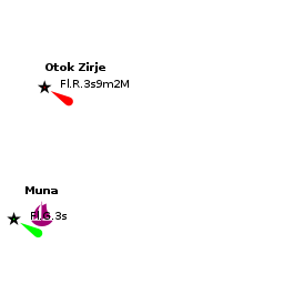
| Luka Muna
| |
| |
 Luka Muna from the SE |
The harbour of Luka Muna is situated halfway along the NE-facing coast of the island of Žirje in Croatia.
The harbour consists of a small, V-shaped inlet quayed at its head and protected from the NW by a breakwater which also acts as the ferry jetty.
Visiting yachts can tie up alongside or, at busy times, stern or bows-to using their anchor on the quay SE of the breakwater or, when a ferry is not due, alongside the ferry jetty.
The inlet is protected in winds from most directions but is open to the NW.
Charts
See Northern Dalmatia.
Weather
See Croatia.
Passages
See Croatia.
Communication
Add here VHF channel for coastguard, harbor masters. etc.
Also see World Cruiser's Nets
There are no dangers in the immediate approach to Luka Muna. Depths in the harbour entrance are 15.0 - 18.0 metres and on the quays 2.0 - 2.5 metres.
Entrance
Šibenik is the nearest all-year round port of entry. During the summer, Sali on Dugi Otok and Primošten on the mainland are also ports of entry.
Berthing
Reportedly in the season, there are approimately 20 berths at the SW quay equipped with mooring lines. Mooring fees are collected, no water and electricity is provided though. The depths at the quay are in range from 2.0 - 2.5 metres and 8.0 - 10.0 metres further out of it.
Note: There are numerous small boat moorings along the quay and care is needed when berthing.
If a ferry is not due, it is also possible to go alongside the ferry jetty, where depths are 8.0 - 10.0 metres, but you must be prepared to move off if a ferry is imminent. Shelter in the harbour is good in all but with N and NW winds.
Marinas & Yacht Clubs
None.
Anchorages
None.
Amenities
None.
Provisioning
![]() [[Luka Muna# | ]] Small shop in the village (a bit towards the head of the harbour).
[[Luka Muna# | ]] Small shop in the village (a bit towards the head of the harbour).
Eating out
![]() [[Luka Muna# | ]] Restaurant, caffé/bar.
[[Luka Muna# | ]] Restaurant, caffé/bar.
Transportation
Car ferries to Šibenik on the mainland.
Tourism
There is little to do except walk the 500 metres up the hill to the island ‘capital’, village of Zirje, where there is a small shop.
Friends
Contact details of "Cruiser's Friends" that can be contacted for local information or assistance.
Forums
List links to discussion threads on partnering forums. (see link for requirements)
Links
See Zirje.
References
See Croatia.
Comments
We welcome users' contributions to the Wiki. Please click on Comments to view other users' comments, add your own personal experiences or recommend any changes to this page following your visit.
Verified by
Date of member's last visit to Luka Muna and this page's details validated:
- August 2005 --Athene of Lymington 17:27, 23 April 2012 (BST)
| This is a usable page of the cruising guide. However, please contribute if you can to help it grow further. Click on Comments to add your personal notes on this page or to discuss its contents. Alternatively, if you feel confident to edit the page, click on the edit tab at the top and enter your changes directly. |
| |
|---|
|
Names: Athene of Lymington |