Mourtos and Sivota Islands
From CruisersWiki
Istioploos (Talk | contribs) m (→External links: Restored standard title) |
Istioploos (Talk | contribs) (Headings) |
||
| Line 13: | Line 13: | ||
! <center>[[image:Chart_icon.png]]</center> | ! <center>[[image:Chart_icon.png]]</center> | ||
| [http://mapserver.mytopo.com/homepage/index.cfm?lat=39.4&lon=20.233333&scale=750000&zoom=100&type=0&icon=0&searchscope=dom&CFID=17583484&CFTOKEN=79232580&scriptfile=http://mapserver.mytopo.com/homepage/index.cfm&latlontype=DMS Local chartlet] | | [http://mapserver.mytopo.com/homepage/index.cfm?lat=39.4&lon=20.233333&scale=750000&zoom=100&type=0&icon=0&searchscope=dom&CFID=17583484&CFTOKEN=79232580&scriptfile=http://mapserver.mytopo.com/homepage/index.cfm&latlontype=DMS Local chartlet] | ||
| + | |- | ||
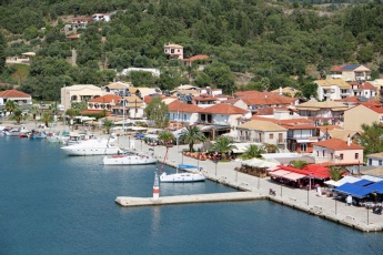
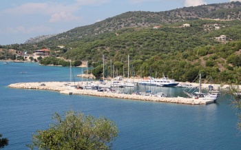
| + | | colspan="2" style="text-align:center; font-size: smaller;" |[[Image:MourtosMarina2.jpg|350px|Mourtos marina from SE<br />''Click for larger view'']] | ||
|} | |} | ||
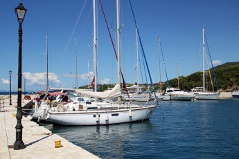
| - | + | [[Image:MourtosMarinaQuay.jpg|345px|thumb|right|Mourtos marina SW corner (note how the moorings cross one another)<br />''Click for larger view'']] | |
| - | [[Image:MourtosMarinaQuay.jpg| | + | [[Image:MourtosTownQuay3.jpg|345px|thumb|right|Mourtos town quay once the charter fleet departs<br />''Click for larger view'']] |
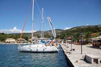
| - | [[Image:MourtosTownQuay3.jpg| | + | [[Image:MourtosTownQuay2.jpg|345px|thumb|right|Mourtos town quay (electricity and water points are under the stone benches)<br />''Click for larger view'']] |
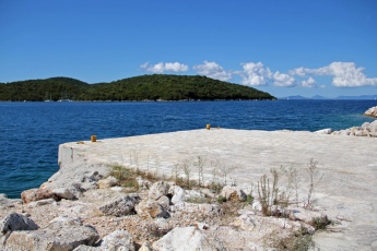
| - | [[Image:MourtosTownQuay2.jpg| | + | [[Image:MourtosStubQuay.jpg|345px|thumb|right|The quay outside the marina has room for one boat alongside<br />''Click for larger view'']] |
| - | [[Image:MourtosStubQuay.jpg| | + | [[Image:MourtosSupermarket.jpg|345px|thumb|right|The supermarket (centre) is on the N side of the harbour<br />''Click for larger view'']] |
| - | [[Image:MourtosSupermarket.jpg| | + | |
[http://en.wikipedia.org/wiki/Mourtos Mourtos] (Μούρτος) is a small village and fishing harbour located on the mainland of Greece opposite the southern part of [[Corfu]], six miles S of Igoumenitsa and three miles S of [[Plataria]]. In recent years it has been rather overtaken by tourism and the small harbour is now used as much by yachts as fishing boats, while the quay is a mass of tourist restaurants and bars. In evenings in the season - especially at weekends - the quay is packed with charter and cruising yachts alike and it can be difficult to find a place. The harbour also contains a small marina, half of which is taken up by local boats and boats on gardiennage, but the other half can be used by visiting yachts. The marina is partly equipped with laid moorings, although some yachts will need to use their anchors. Nearby are several anchorages, including around the Sivota or Syvota (Σύβοτα) islands, which offer good shelter in the prevailing winds. | [http://en.wikipedia.org/wiki/Mourtos Mourtos] (Μούρτος) is a small village and fishing harbour located on the mainland of Greece opposite the southern part of [[Corfu]], six miles S of Igoumenitsa and three miles S of [[Plataria]]. In recent years it has been rather overtaken by tourism and the small harbour is now used as much by yachts as fishing boats, while the quay is a mass of tourist restaurants and bars. In evenings in the season - especially at weekends - the quay is packed with charter and cruising yachts alike and it can be difficult to find a place. The harbour also contains a small marina, half of which is taken up by local boats and boats on gardiennage, but the other half can be used by visiting yachts. The marina is partly equipped with laid moorings, although some yachts will need to use their anchors. Nearby are several anchorages, including around the Sivota or Syvota (Σύβοτα) islands, which offer good shelter in the prevailing winds. | ||
| Line 39: | Line 40: | ||
==Weather== | ==Weather== | ||
| - | * ''See [[Ionian Sea#Weather_and_Winds|Ionian Sea Weather]]'' | + | * ''See [[Ionian Sea#Weather_and_Winds|Ionian Sea Weather]]''. |
* ''Also see [[Ionian Sea#Currents_&_Tides|Ionian Sea Currents & Tides]]'' | * ''Also see [[Ionian Sea#Currents_&_Tides|Ionian Sea Currents & Tides]]'' | ||
| Line 51: | Line 52: | ||
==Berthing Options== | ==Berthing Options== | ||
| - | ===Town quay=== | + | ===Ports=== |
| + | ====Town quay==== | ||
Mourtos town quay extends for around 300 metres at the head of the inlet. The N third is occupied by small fishing boats on moorings, but the remainder is available to yachts moored bows or stern-to using their anchors. Depths along the quay are from 2.0 metres at the N end to 2.25 metres at the S end (where there is a short ramped ferry quay). The quay continues S after the ferry quay with depths increasing from 2.25 to 3.0 metres and deeper draft yachts tend to make for this spot. Depths increase gradually off the quay, and there is 2.5 metres along most of it where a yacht’s keel would be. The quay is plentifully supplied with bollards and mooring staples in good condition. Water and electricity points are concealed under the stone benches along the quay. Shelter here is reasonable in the prevailing NW winds, but strong winds from this direction cause a heavy swell and the whole of the town quay could become untenable. | Mourtos town quay extends for around 300 metres at the head of the inlet. The N third is occupied by small fishing boats on moorings, but the remainder is available to yachts moored bows or stern-to using their anchors. Depths along the quay are from 2.0 metres at the N end to 2.25 metres at the S end (where there is a short ramped ferry quay). The quay continues S after the ferry quay with depths increasing from 2.25 to 3.0 metres and deeper draft yachts tend to make for this spot. Depths increase gradually off the quay, and there is 2.5 metres along most of it where a yacht’s keel would be. The quay is plentifully supplied with bollards and mooring staples in good condition. Water and electricity points are concealed under the stone benches along the quay. Shelter here is reasonable in the prevailing NW winds, but strong winds from this direction cause a heavy swell and the whole of the town quay could become untenable. | ||
Note that the quay is very busy at weekends during the season with yacht charter handovers, principally by the Neilson company, and there is unlikely to be room at that time. | Note that the quay is very busy at weekends during the season with yacht charter handovers, principally by the Neilson company, and there is unlikely to be room at that time. | ||
| - | ===Marina=== | + | ====Marina==== |
Mourtos marina, after many years as a dusty and half-finished monument to thwarted aspirations, is now (more or less) in business. Mooring blocks have been laid and there are mooring lines around the N and W side of the marina, although just two or three remain on the S side. Depths throughout the marina are 3.5 - 3.75 metres. ‘Proper’ yacht moorings are at the top of the marina, the W end, where some 10 yachts can tie up using lines tailed to the quay (more if and when the rusting ferry in the NW corner is moved). Along the S side there are only three lines at present (September 2012) and they are very short and only suitable for relatively small yachts. Otherwise, if there are no spaces at the top of the marina, use your anchor to moor in one of the gaps on the S side. The moorings here are short and go down to blocks, so there is no danger as long as you lay your anchor in the middle of the basin. Holding is good in mud and weed. Finally, it is also possible to go alongside on the end of the S quay if it is not in use by a hotel or fishing boat, or alongside a short stub quay on the OUTSIDE of the marina breakwater (this latter position only in settled weather), which has 3.0 metre depths off it. | Mourtos marina, after many years as a dusty and half-finished monument to thwarted aspirations, is now (more or less) in business. Mooring blocks have been laid and there are mooring lines around the N and W side of the marina, although just two or three remain on the S side. Depths throughout the marina are 3.5 - 3.75 metres. ‘Proper’ yacht moorings are at the top of the marina, the W end, where some 10 yachts can tie up using lines tailed to the quay (more if and when the rusting ferry in the NW corner is moved). Along the S side there are only three lines at present (September 2012) and they are very short and only suitable for relatively small yachts. Otherwise, if there are no spaces at the top of the marina, use your anchor to moor in one of the gaps on the S side. The moorings here are short and go down to blocks, so there is no danger as long as you lay your anchor in the middle of the basin. Holding is good in mud and weed. Finally, it is also possible to go alongside on the end of the S quay if it is not in use by a hotel or fishing boat, or alongside a short stub quay on the OUTSIDE of the marina breakwater (this latter position only in settled weather), which has 3.0 metre depths off it. | ||
There are water and electricity points around the marina; a marina attendant is frequently around and will connect you to either for a charge of €5 a day (or both for €10). Shelter in the marina is better than the town quay, although there is an uncomfortable back swell from the town quay in strong NW winds. | There are water and electricity points around the marina; a marina attendant is frequently around and will connect you to either for a charge of €5 a day (or both for €10). Shelter in the marina is better than the town quay, although there is an uncomfortable back swell from the town quay in strong NW winds. | ||
| - | ==Anchorages== | + | ===Anchorages=== |
For a map of all the anchorages around Mourtos/Sivota, click on this link [https://maps.google.co.uk/maps/ms?msid=210561298658189797082.0004c9fa1f71ac86296a5&msa=0&ll=39.405958,20.236216&spn=0.017508,0.038409]. | For a map of all the anchorages around Mourtos/Sivota, click on this link [https://maps.google.co.uk/maps/ms?msid=210561298658189797082.0004c9fa1f71ac86296a5&msa=0&ll=39.405958,20.236216&spn=0.017508,0.038409]. | ||
| - | + | ====Agios Nikolaos Island==== | |
| - | + | ||
Yachts unable to find a place on the quay, or preferring to lie at anchor, can usually find a space to anchor in the channel between the mainland and the closest of the islands, N. Agios Nikolaos. Unfortunately, the best and most sheltered spot, a small cove at the NE end of the island, is now taken up with fore and aft moorings, so yachts need to anchor further out. Depths in the centre of the channel are quite deep (6.0 - 9.0 metres) and some yachts take lines to the shore. The channel shallows as you get further in to little over 2.0 metres. Note that between mid morning and early evening this channel is used by numerous water taxis, small tour boats, and other water craft passing from Mourtos round to the beach developments to the south. Shelter is good here in the prevailing NW winds and little swell creeps in. | Yachts unable to find a place on the quay, or preferring to lie at anchor, can usually find a space to anchor in the channel between the mainland and the closest of the islands, N. Agios Nikolaos. Unfortunately, the best and most sheltered spot, a small cove at the NE end of the island, is now taken up with fore and aft moorings, so yachts need to anchor further out. Depths in the centre of the channel are quite deep (6.0 - 9.0 metres) and some yachts take lines to the shore. The channel shallows as you get further in to little over 2.0 metres. Note that between mid morning and early evening this channel is used by numerous water taxis, small tour boats, and other water craft passing from Mourtos round to the beach developments to the south. Shelter is good here in the prevailing NW winds and little swell creeps in. | ||
| - | + | ====Monastery Bay==== | |
| - | + | ||
An alternative anchorage is Monastery Bay, the bay half a mile NW of the harbour, where there is a small beach, large leisure complex and a taverna. Anchor in 5.0 – 6.0 metres wherever there is space. Holding is good in sand, mud and weed. Shelter is good from the prevailing NW winds, but the anchorage is open SW. If you see a flotilla moored on the long pontoon extending 50 metres out from the leisure complex, go elsewhere as it means the night club above will be blaring until the early hours. Depths on this pontoon, which is for customers of the Torre E Mare leisure complex above, are 2.0 - 2.25 metres, but the inner 25-30 metres or so are unusable because of large concrete pipes on the bottom. There is also little to tie on to except the rough iron brackets which fasten the blue plastic pipes used as fenders onto the edge of the pontoon. | An alternative anchorage is Monastery Bay, the bay half a mile NW of the harbour, where there is a small beach, large leisure complex and a taverna. Anchor in 5.0 – 6.0 metres wherever there is space. Holding is good in sand, mud and weed. Shelter is good from the prevailing NW winds, but the anchorage is open SW. If you see a flotilla moored on the long pontoon extending 50 metres out from the leisure complex, go elsewhere as it means the night club above will be blaring until the early hours. Depths on this pontoon, which is for customers of the Torre E Mare leisure complex above, are 2.0 - 2.25 metres, but the inner 25-30 metres or so are unusable because of large concrete pipes on the bottom. There is also little to tie on to except the rough iron brackets which fasten the blue plastic pipes used as fenders onto the edge of the pontoon. | ||
| - | + | ====Sand Bar Bay==== | |
| - | There are two further anchorages on the S side of the Sivota Islands which visiting yachts can use. They lie either side of a sand bar joining the little island of Nisis Mavros Notos to the mainland. Both anchorages are heavily used by the Neilson hotel complex which now dominates this area, but it is possible to anchor here if you are careful to keep out of the way of the Neilson water sports activities. Sadly, these anchorages, beautiful as they are, are no longer the idyllic ones they once were and you will get little peace here during the season | + | There are two further anchorages on the S side of the Sivota Islands which visiting yachts can use. They lie either side of a sand bar joining the little island of Nisis Mavros Notos to the mainland. Both anchorages are heavily used by the Neilson hotel complex which now dominates this area, but it is possible to anchor here if you are careful to keep out of the way of the Neilson water sports activities. Sadly, these anchorages, beautiful as they are, are no longer the idyllic ones they once were and you will get little peace here during the season |
| - | <center style="clear: both;"><gallery | + | |
| + | <center style="clear: both;"><gallery widths="210px" heights="150px" perrow="2"> | ||
Image:SandBarBarE.jpg|Anchorage of Sand Bar Bay East from N | Image:SandBarBarE.jpg|Anchorage of Sand Bar Bay East from N | ||
Image:SandBarBayW.jpg|Anchorage of Sand Bar Bay West from N | Image:SandBarBayW.jpg|Anchorage of Sand Bar Bay West from N | ||
| Line 82: | Line 83: | ||
==Marinas & Yacht Clubs== | ==Marinas & Yacht Clubs== | ||
| - | Mourtos marina | + | [[#Marina|Mourtos marina]]. |
| + | |||
| + | ==Offshore Islands== | ||
| + | ''See [[#Anchorages|Anchorages]]''. | ||
==Yacht Services and Repairs== | ==Yacht Services and Repairs== | ||
| Line 95: | Line 99: | ||
: It may be possible to have fuel delivered by mini-tanker to the village quay. Check with the locals. | : It may be possible to have fuel delivered by mini-tanker to the village quay. Check with the locals. | ||
; Water | ; Water | ||
| - | : Available on the quay and in the marina. On the quay, note that the taps are locked and that you will have to find the keyholder to open the lock for you. There may be a charge. Water also in the marina (€5 per day). | + | : Available on the quay and in the [[#Marina|marina]]. On the quay, note that the taps are locked and that you will have to find the keyholder to open the lock for you. There may be a charge. Water also in the [[#Marina|marina]] (€5 per day). |
; Electricity | ; Electricity | ||
| - | : Available on the quay (connection points concealed under the stone benches along the quay). Also in the marina (€5 per day) | + | : Available on the quay (connection points concealed under the stone benches along the quay). Also in the [[#Marina|marina]] (€5 per day). |
| - | + | ||
| - | + | ||
| - | + | ||
==Tourism and Things to do Ashore== | ==Tourism and Things to do Ashore== | ||
| - | ===Tourism=== | + | ====Tourism==== |
Mourtos is a pretty village, in spite of being now largely given over to tourism, and there are some good walks in the hinterland. However, most of its attractions are on and around the water and on a yacht you are in the best place to appreciate tham. | Mourtos is a pretty village, in spite of being now largely given over to tourism, and there are some good walks in the hinterland. However, most of its attractions are on and around the water and on a yacht you are in the best place to appreciate tham. | ||
| - | ===Grocery & Supply Stores=== | + | ====Grocery & Supply Stores==== |
Very good supermarket and fruiterer on the north side of the harbour. | Very good supermarket and fruiterer on the north side of the harbour. | ||
| - | ===Eateries=== | + | ====Eateries==== |
* Numerous restaurants, bars and cafes. | * Numerous restaurants, bars and cafes. | ||
* Maria and Georgeo’s Taverna on the waterfront is popular with the locals. | * Maria and Georgeo’s Taverna on the waterfront is popular with the locals. | ||
| - | ===Internet/WiFi=== | + | ====Internet/WiFi==== |
| - | In several of the waterfront cafes and the Hotel Filakas. | + | In several of the waterfront cafes and the ''Hotel Filakas''. |
| - | ===Laundry=== | + | ====Laundry==== |
None. | None. | ||
| - | ===Motorbike & Car Rentals=== | + | ====Motorbike & Car Rentals==== |
Through local travel agents. | Through local travel agents. | ||
| - | ===Garbage Disposal=== | + | ====Garbage Disposal==== |
| - | Garbage skip at the marina, on the N side of the harbour and on the roadside 100 metres back from the harbour. | + | Garbage skip at the [[#Marina|marina]], on the N side of the harbour and on the roadside 100 metres back from the harbour. |
| - | ===Transportation=== | + | ====Transportation==== |
Transportation (local and/or international) | Transportation (local and/or international) | ||
*Local ferries only. | *Local ferries only. | ||
| Line 148: | Line 149: | ||
''See [[Greece#References_&_Publications|Greece]]''. | ''See [[Greece#References_&_Publications|Greece]]''. | ||
| - | ==Last Visited & Details Checked (and updated here)== | + | ==Personal Notes== |
| + | This anchorage used to be an attractive anchorage on the mainland, just off the southern tip of Corfu, but my understanding is that it has been spoiled by heavy concrete development. --[[User:Istioploos|Istioploos]] | ||
| + | |||
| + | This is sadly true of the S side of the Sivota Islands, which is now dominated by large hotel complexes, but Mourtos itself is still very attractive and not yet spoilt. The completion (more or less) of the marina also makes it a much better port of call than before. --[[User:Atheneoflymington|Athene of Lymington]] | ||
| + | |||
| + | ====Last Visited & Details Checked (and updated here)==== | ||
''Date of member's visit to this Port/Stop & this page's details validated'': | ''Date of member's visit to this Port/Stop & this page's details validated'': | ||
* July 1988 --[[User:Istioploos|Istioploos]] [[Image:Greece_Icon.png]] | * July 1988 --[[User:Istioploos|Istioploos]] [[Image:Greece_Icon.png]] | ||
| Line 154: | Line 160: | ||
* September 2012 --[[User:Atheneoflymington|Athene of Lymington]] 13:00, 17 September 2012 (BST) | * September 2012 --[[User:Atheneoflymington|Athene of Lymington]] 13:00, 17 September 2012 (BST) | ||
| - | |||
| - | |||
| - | + | {{Guide2}} | |
| + | |||
<br /> | <br /> | ||
| Line 176: | Line 181: | ||
| - | [[Category:Ports - Greece]] [[Category:Anchorages - Greece]] | + | [[Category:Ports - Greece]] [[Category:Anchorages - Greece]] [[Category:Islands - Greece]] |
Revision as of 23:12, 15 January 2013
Mourtos & Sivota Islands
| | |
| | 39°24′N, 20°14′E |
|---|---|
| | Photo gallery |
| | Local chartlet |
| |
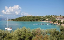
Mourtos (Μούρτος) is a small village and fishing harbour located on the mainland of Greece opposite the southern part of Corfu, six miles S of Igoumenitsa and three miles S of Plataria. In recent years it has been rather overtaken by tourism and the small harbour is now used as much by yachts as fishing boats, while the quay is a mass of tourist restaurants and bars. In evenings in the season - especially at weekends - the quay is packed with charter and cruising yachts alike and it can be difficult to find a place. The harbour also contains a small marina, half of which is taken up by local boats and boats on gardiennage, but the other half can be used by visiting yachts. The marina is partly equipped with laid moorings, although some yachts will need to use their anchors. Nearby are several anchorages, including around the Sivota or Syvota (Σύβοτα) islands, which offer good shelter in the prevailing winds.
Charts
- BA
- 206 Corfu: Channels
- Imray-Tetra
- G11 Nísos Kérkira to Nísos Levkas
- NIMA
- 54280 Corfu Channel to Nisis Proti
- Greek
- 10 Kerkyra
Radio Nets
Also see Cruiser's Nets
- Coast Guard VHF Channel 12
Weather
- See Ionian Sea Weather.
- Also see Ionian Sea Currents & Tides
There are no obvious hazards in the approaches to Mourtos, though yachtsmen should refer to official charts and pilots for full details. The passages between the Sivota Islands are mostly too shallow for yachts to transit, although some use the channel between the mainland and the nearest of the islands, Nisos Agios Nikolaos.
I have passed though myself on several occasions drawing 1.8 metres. The water is usually very clear in the channel. --Istioploos ![]()
Check-in facilities
None. The nearest port of entry is Corfu Town.
Berthing Options
Ports
Town quay
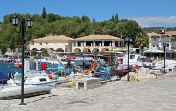
Mourtos town quay extends for around 300 metres at the head of the inlet. The N third is occupied by small fishing boats on moorings, but the remainder is available to yachts moored bows or stern-to using their anchors. Depths along the quay are from 2.0 metres at the N end to 2.25 metres at the S end (where there is a short ramped ferry quay). The quay continues S after the ferry quay with depths increasing from 2.25 to 3.0 metres and deeper draft yachts tend to make for this spot. Depths increase gradually off the quay, and there is 2.5 metres along most of it where a yacht’s keel would be. The quay is plentifully supplied with bollards and mooring staples in good condition. Water and electricity points are concealed under the stone benches along the quay. Shelter here is reasonable in the prevailing NW winds, but strong winds from this direction cause a heavy swell and the whole of the town quay could become untenable.
Note that the quay is very busy at weekends during the season with yacht charter handovers, principally by the Neilson company, and there is unlikely to be room at that time.
Marina
Mourtos marina, after many years as a dusty and half-finished monument to thwarted aspirations, is now (more or less) in business. Mooring blocks have been laid and there are mooring lines around the N and W side of the marina, although just two or three remain on the S side. Depths throughout the marina are 3.5 - 3.75 metres. ‘Proper’ yacht moorings are at the top of the marina, the W end, where some 10 yachts can tie up using lines tailed to the quay (more if and when the rusting ferry in the NW corner is moved). Along the S side there are only three lines at present (September 2012) and they are very short and only suitable for relatively small yachts. Otherwise, if there are no spaces at the top of the marina, use your anchor to moor in one of the gaps on the S side. The moorings here are short and go down to blocks, so there is no danger as long as you lay your anchor in the middle of the basin. Holding is good in mud and weed. Finally, it is also possible to go alongside on the end of the S quay if it is not in use by a hotel or fishing boat, or alongside a short stub quay on the OUTSIDE of the marina breakwater (this latter position only in settled weather), which has 3.0 metre depths off it.
There are water and electricity points around the marina; a marina attendant is frequently around and will connect you to either for a charge of €5 a day (or both for €10). Shelter in the marina is better than the town quay, although there is an uncomfortable back swell from the town quay in strong NW winds.
Anchorages
For a map of all the anchorages around Mourtos/Sivota, click on this link [1].
Agios Nikolaos Island
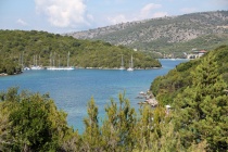
Yachts unable to find a place on the quay, or preferring to lie at anchor, can usually find a space to anchor in the channel between the mainland and the closest of the islands, N. Agios Nikolaos. Unfortunately, the best and most sheltered spot, a small cove at the NE end of the island, is now taken up with fore and aft moorings, so yachts need to anchor further out. Depths in the centre of the channel are quite deep (6.0 - 9.0 metres) and some yachts take lines to the shore. The channel shallows as you get further in to little over 2.0 metres. Note that between mid morning and early evening this channel is used by numerous water taxis, small tour boats, and other water craft passing from Mourtos round to the beach developments to the south. Shelter is good here in the prevailing NW winds and little swell creeps in.
Monastery Bay
An alternative anchorage is Monastery Bay, the bay half a mile NW of the harbour, where there is a small beach, large leisure complex and a taverna. Anchor in 5.0 – 6.0 metres wherever there is space. Holding is good in sand, mud and weed. Shelter is good from the prevailing NW winds, but the anchorage is open SW. If you see a flotilla moored on the long pontoon extending 50 metres out from the leisure complex, go elsewhere as it means the night club above will be blaring until the early hours. Depths on this pontoon, which is for customers of the Torre E Mare leisure complex above, are 2.0 - 2.25 metres, but the inner 25-30 metres or so are unusable because of large concrete pipes on the bottom. There is also little to tie on to except the rough iron brackets which fasten the blue plastic pipes used as fenders onto the edge of the pontoon.
Sand Bar Bay
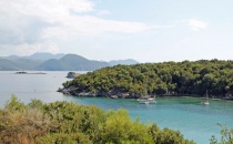
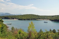
There are two further anchorages on the S side of the Sivota Islands which visiting yachts can use. They lie either side of a sand bar joining the little island of Nisis Mavros Notos to the mainland. Both anchorages are heavily used by the Neilson hotel complex which now dominates this area, but it is possible to anchor here if you are careful to keep out of the way of the Neilson water sports activities. Sadly, these anchorages, beautiful as they are, are no longer the idyllic ones they once were and you will get little peace here during the season
Marinas & Yacht Clubs
Offshore Islands
See Anchorages.
Yacht Services and Repairs
Marine Stores
Effectively none.
Yacht Services/Repairs/Yards
None.
Fuel, Water, & Electricity
- Fuel
- It may be possible to have fuel delivered by mini-tanker to the village quay. Check with the locals.
- Water
- Available on the quay and in the marina. On the quay, note that the taps are locked and that you will have to find the keyholder to open the lock for you. There may be a charge. Water also in the marina (€5 per day).
- Electricity
- Available on the quay (connection points concealed under the stone benches along the quay). Also in the marina (€5 per day).
Tourism and Things to do Ashore
Tourism
Mourtos is a pretty village, in spite of being now largely given over to tourism, and there are some good walks in the hinterland. However, most of its attractions are on and around the water and on a yacht you are in the best place to appreciate tham.
Grocery & Supply Stores
Very good supermarket and fruiterer on the north side of the harbour.
Eateries
- Numerous restaurants, bars and cafes.
- Maria and Georgeo’s Taverna on the waterfront is popular with the locals.
Internet/WiFi
In several of the waterfront cafes and the Hotel Filakas.
Laundry
None.
Motorbike & Car Rentals
Through local travel agents.
Garbage Disposal
Garbage skip at the marina, on the N side of the harbour and on the roadside 100 metres back from the harbour.
Transportation
Transportation (local and/or international)
- Local ferries only.
Routes/Passages To/From
Cruiser's Friends
Contact details of "Cruiser's Friends" that can be contacted for local information or assistance.
Forum Discussions
List links to discussion threads on partnering forums. (see link for requirements)
External Links
- Mourtos (Wikepedia)
References & Publications
See Greece.
Personal Notes
This anchorage used to be an attractive anchorage on the mainland, just off the southern tip of Corfu, but my understanding is that it has been spoiled by heavy concrete development. --Istioploos
This is sadly true of the S side of the Sivota Islands, which is now dominated by large hotel complexes, but Mourtos itself is still very attractive and not yet spoilt. The completion (more or less) of the marina also makes it a much better port of call than before. --Athene of Lymington
Last Visited & Details Checked (and updated here)
Date of member's visit to this Port/Stop & this page's details validated:
- July 1988 --Istioploos

- August 2010 --Wayward

- September 2012 --Athene of Lymington 13:00, 17 September 2012 (BST)
|
|---|
|
Names: Lighthouse, Istioploos, Wayward, Athene of Lymington |
| |
|---|
| | HOMEPAGE | Wiki Contents | Mediterranean | Ionian Sea | Greece | Mourtos and Sivota Islands | |
