Corfu
From CruisersWiki
An online cruising guide for yachts sailing to Corfu.
| Corfu There are Port(s) of Entry here
| |
| | |
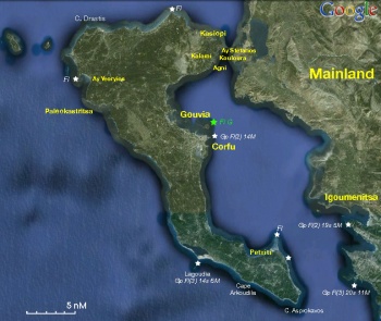
Corfu or Kerkyra (Κέρκυρα) is the northernmost and second largest, after Cephalonia, of the Ionian Islands. Its area covers 592 km2 and the length of the island is 217 km. It is mountainous with the highest mountain being Mt. Pantokrator (914 m) but there are several flat areas, the largest being the Ropa valley. There are two lakes: Korission and Antinioti, and four small rivers, often dry in summer at Potamos, Sidari, Messogghi and Lefkimi. The climate is mild without being bitterly cold in winter and the summers are humid. The heavy rainfall and the high humidity encourage the profuse growth of vegetation. Therefore, the island has a lot of greenery, even in the summer. It is the most densely populated area in Greece after the great urban centers of Athens and Thessalonica. According to the latest census figures, the population of the island is 105,000 with 35,000 people living in the town. In addition, it is the single most popular tourist destination in Greece, with over one million visitors to the island annually.
Berthing options on the island include the capital and main ferry terminal, Corfu Town, the small harbours of Kassiopi on the N coast of the island, Petriti on the SE and Palaiokastritsa on the NW coast and numerous attractive anchorages, especially those of Agni, Kalami, Kouloura and Ayios Stefanos at the NE tip and Ayios Yeoryios on the NW coast.
Charts
- BA
- 206 Corfu: Channels
- Imray-Tetra
- G11 Nísos Kérkira to Nísos Levkas
- NIMA
- 54280 Corfu Channel to Nisis Proti
- Greek
- 2 Ionio Pelagos
- 10 Kerkyra
- 211 Kerkyra I. - Otranto Strait
Weather
- See Ionian Sea Weather
- Also see Ionian Sea Currents & Tides
Passages
Islands
- Paxos or Paxoi - to the S of Corfu
- Othoni - to the N of Corfu
- Erikoussa - to the N of Corfu
Communication
- Coast Guard - VHF channel 12
- Olympia Radio - VHF channel 02, 03, & 64
Also see World Cruiser's Nets.
See individual ports.
Entrance
If you are entering or exiting Greece you can either go to Corfu Town or to Gouvia Marina. The latter is generally easier for yachts.
Note: It is not necessary to berth in the marina to visit the Port Police. Many yachts anchor in the bay on the north side immediately before the buoyed channel into the marina.
Some non-EU flagged boats paid €30 and some paid €45 to Customs during the clearance process, and all paid an additional €15 to the Coast Guard for issuance of the Transit Log in April 2017. Receipts were provided.
Berthing
Ports
- Kassiopi |
 – anchorage |
 - Petriti |
 – anchorage |
 - Palaiokastritsa |
 – anchorage |
Marinas & Yacht Clubs
- Corfu Yacht Club
- NAOK Yacht Club
Anchorages
Gouvia
Gouvia Bay is located five nM north of Corfu town and features a Venetian arsenal of 1716. One can climb to the summit of Mount Pantokrator for a beautiful view of the surroundings and an abandoned monastery of 1347. The village of Kondokali - adjacent to Gouvia - is nowadays more German or English than Greek. Fortunately, the facilities are excellent. Yachts are not permitted to anchor in the bay, but may anchor in the bay of
Ormos Kammeno immediately N of the entrance to Gouvia Bay. The location is convenient for visiting the Port Police in the nearby Gouvia Marina and also for the chandleries, shops, laundry outside the marina. Depths generally 6.0 – 10.0 metres. Holding is good in mud and weed. The anchorage is subject to water skiers and other power boats from the hotel at the east end of the bay. Gouvia Marina, one of the oldest in Greece, is the safest place to leave the boat for any period and explore this lush island.Agni
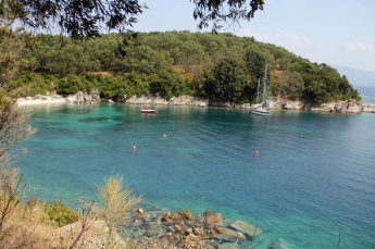
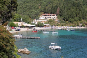
Agni bay is the first of the anchorages on the NE tip of Corfu, heading N from Corfu Town. The S part of the bay is lined with tavernas, some with long jetties to the end of which a yacht may anchor and take a line with care. Depths at pier ends are 2.5 metres not the 4 metres advertised by the patrons. Most yachts tend to anchor off in depths of 8.0 – 10 metres. It is also possible to take a long line ashore on the S side, but this will leave you beam on to any swell. The holding is good in sand, mud and weed. Shelter is good from the prevailing NW winds, but, like all the anchorages along this coast, it is open E and S and is likely to be untenable in strong winds from that quarter. Also, like all the others, it is subject to swell from passing ferries and ships. Alternatively, it is possible to anchor with care off the small beach at the N end of Agni Bay. There is really only room for one yacht to anchor fore and aft here in 7.0 – 8.0 metres, but 2-3 can fit in if they each take a line ashore to the E side of the cove (the W side is steep-to and there is little to take a line to). Be careful to avoid the small mooring buoys used by visiting day boats. Depths here are 3.0 – 3.5 metres at 10 metres off the rocks. The holding is good in sand and weed once your anchor is through the weed. There is a cliff path from here round to the tavernas at the S end of the bay. Shelter is good from the prevailing winds, although an occasional heavy swell enters from passing ships.
Kalami
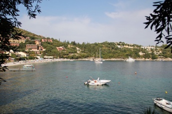
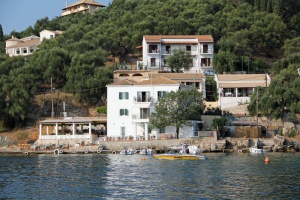
Kalami Bay is the next anchorage on the NE tip of Corfu, heading N from Corfu Town. It is the biggest of the anchorages here and can take perhaps 10-15 yachts before it begins to get crowded. Anchor 50 metres off the beach in 5.0 – 8.0 metre depths in sand and weed. Good holding once through the weed. It is also possible to take a line ashore to the rocks in the NW corner, where there are iron posts set into the rocks just S of the water skiing pontoon. The White House Restaurant, former home of the writer Lawrence Durrell, is excellent and well worth patronizing. Other tavernas, cafes and three good supermarkets ashore. Shelter is good from the prevailing winds, although an occasional heavy swell enters from passing ships.
Kouloura
Ayios Stefanos
Ayios Vroulias
Ayios Yeoryios
Amenities
Also see each port above.
| Facilities | |
|---|---|
| Water | At Gouvia Marina |
| Electricity | At Gouvia Marina |
| Toilets | At Gouvia Marina |
| Showers | in Gouvia Marina |
| Laundry |
|
| Garbage | ? |
| Supplies | |
| Fuel | At Gouvia Marina |
| Bottled gas | ? |
| Chandlers |
|
| Services | |
| Repairs | Gouvia Marina: It is small but excellent |
| Internet | See individual port entries. |
| Mobile connectivity | Good 4G signal. |
| Vehicle rentals | At Corfu Town & Gouvia Marina |
Provisioning
See individual port entries.
Transportation
- Flights - Scheduled and charter flights to the UK and other European countries. Domestic flights to Athens. Sea-plane to Patras. Please note that in the winter, flights are often canceled.
- Ferries - Frequent ferries to Igoumenitsa on the mainland. Also ferries to Patras in the Gulf of Corinth and international ferries to Italy.
- Buses - It is possible to get on a bus in Corfu that will take you to Athens. This can be more convenient than taking the ferry to Igoumenitsa and then having to find the bus station there.
Eating out
See individual port entries.
Tourism
History
According to Mythology, the name of Kerkyra in Greek is derived from the nymph Korkira, daughter of the Asopos River. Mythology says that Poseidon, the god of the sea, fell in love with the nymph, kidnapped her and brought her on the island which took it name. Homer’s “Odyssey” relates the island to one of the adventures of Ulysses. It is the island where he met Nausicaa, the daughter of the King Acinous.
The first Greek settlers were Eritreans from Euboea in the 8th Century. Later, a group of refugees from Corinth came on the island and founded a colony. The town, trading with all the towns of the Adriatic Sea, quickly became an important commercial center with a powerful navy. It also developed an important colonial activity and became independent from Corinth. The two towns became competitors and many conflicts took place between them. During an important battle, Corfu asked for help to the Athenians. The Athenian support to Corfu was one more reason for the rise of the Peloponnesian Wars. The alliance between the two towns lasted for almost a century when the Macedonians, under Philip II, won a decisive battle in 338 B.C.
The Macedonians conquered Corfu and put it under their protection. The island, in 300 B.C., was attacked and conquered by the Spartans. They were followed Illyrians and then by the Romans.The Romans ruled on the island from 229 B.C. until 337 A.D. During their rule the island had some autonomy but, in return, Corfu had to allow the Romans to use the town’s port and ships. Around 40 B.C., two Christian disciples of Saint Paul, Jasonas and Sossipatros brought Christianity on the island, built the first Christian church which was dedicated to Saint Stefanos and preached Christianity.
In 285 A.D. the Roman Empire was divided into the Western and Eastern Empires. The Eastern Roman Empire became later the Byzantine Empire and included the island of Corfu. The Byzantine period lasted until 1267 A.D. During this period, the island was constantly attacked by pirates, barbarians, Goths, and Saracens; no constant peace could be established.
The island also fell for a short period under the rule of the Normans and then Venetians. Half a century of peace followed the Venetian rule when a new threat from Sicily arose. In 1267, Charles of Anjou, the French King of Sicily, conquered the island of Corfu and attempted to replace the Orthodox religion by the Catholic. The Angevins dynasty persecuted the Christians Orthodox and all the churches were converted to Catholicism. The attempt of converting the people to Catholicism failed and the island of Corfu fell again, in 1386, under the Venetian rule. The Venetians were on the island from 1386 until 1797 while the rest of the Greece was under the Ottoman rule. During that period, the island was victim to many pirates’ attacks. The island had a feudal organization and was divided in three classes: the nobles, the bourgeoisie and the commoners. The nobles’ exploitation of the majority led to constant insurrections which were severely suppressed.
In 1797, after Napoleon Bonaparte conquered Venice and after the treaty of Kamboformio was signed, Corfu became part of the French State. Napoleon Bonaparte came on the island as a liberator and burnt publicly the “Libro d’Oro”, the book enumerating the Noble’s privileges. Two years later, in 1799, the fleet of the alliance of the Ottomans, the Russians and the English defeated the French and disembarked on Corfu.
On March 1800, the Septinsular Republic was established in Constantinople but the attempt failed in 1807 when the island was ceded to France again. It was a period of prosperity with agricultural improvements. The Ionian Academy was founded, schools were built and the public services reorganized. During this time, the English started occupying other Ionians Islands and finally occupied Corfu in 1815. The occupation was made official after the Treaty of Paris in 1815. During their occupation, the Greek language became official, new roads were built, the water supply of the town was organized and the education system improved with the founding of the first Greek University in 1824. Although the island of Corfu has never been controlled by the Ottomans, the inhabitants offered financial help to the rest of Greece which was still under the Ottoman rule and helped them to make the Greek Revolution for Independence.
The Ionians Islands were finally unified to the newly built Greek State in the 21 May 1864. In the 20th century, the island participated as the rest of Greece in the two World Wars. The island suffered great damages and the Ionian Academy, the Library, and the Municipal Theatre were burnt down.
Places to Visit
The whole island is interesting, if overcrowded. It is best to rent a car or a scooter and allow a few days for exploration. Many of the inland villages are most attractive. Corfu Town itself is a bustling center of activity. In the evening the old town becomes very much alive with numerous restaurants, cafes and bars setting out tables in every conceivable bit of space.
Friends
Contact details of "Cruiser's Friends" that can be contacted for local information or assistance.
Forums
List links to discussion threads on partnering forums. (see link for requirements)
Links
- Corfu at the Wikipedia
- a yachtsman's video guide
References
- Gerald Durrell, My Family and Other Animals, Penguin Books, ISBN 978-0142004418
- Gerald Durrell, Birds, Beasts, and Relatives, Penguin Books, ISBN 978-0142004401
Comments
We welcome users' contributions to the Wiki. Please click on Comments to view other users' comments, add your own personal experiences or recommend any changes to this page following your visit.
Regarding the Kalami anchorage -- we stayed here for one night in July 2021. Despite calm weather otherwise, in the evening there were very strong catabatic gusts of wind up to 20 KTS. They lasted from 6 pm to 22 pm. Make sure to drop a lot of anchor. The anchor of one of our neighbors dragged very suddenly.
Verified by
Date of member's last visit to Corfu and this page's details validated:
- July 1988 --Istioploos

- August 2010 --Wayward

- September 2012 --Athene of Lymington 17:40, 16 September 2012 (BST)
- June 2016 -- Monterey

| This is a usable page of the cruising guide. However, please contribute if you can to help it grow further. Click on Comments to add your personal notes on this page or to discuss its contents. Alternatively, if you feel confident to edit the page, click on the edit tab at the top and enter your changes directly. |
| |
|---|
|
Names: Lighthouse, Istioploos, Atheneoflymington, Wayward, Haiqu, Monterey |
