Mykonos
From CruisersWiki
(→Tourlos) |
|||
| Line 71: | Line 71: | ||
===Tourlos=== | ===Tourlos=== | ||
| + | [[image:World_icon.png]] {{Coord|37|27.9|N|25|19.5|E|}}<br /> | ||
The old Mykonos harbour is now closed for yachts. | The old Mykonos harbour is now closed for yachts. | ||
Revision as of 17:36, 28 May 2012
Mykonos
| | |
| | 37°27′N, 25°19.5′E |
|---|---|
| | Photo gallery |
| | Local chartlet |
|
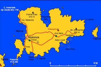
Mykonos (Μύκονος) or Mikonos or Myconos is a barren island in the middle of the Cyclades. It is maybe the island that attracts the most tourists. Because of this and despite its many lovely beaches many cruisers tend to avoid it.
Visiting yachts normally berth at the uncompleted Mykonos Marina two miles W of the main town, which is the only safe harbour on the island. Since its partial completion, yachts are no longer permitted to berth in Mykonos old harbour, which is reserved for tripper boats.
According to the mythology Mykonos was a rock hurled at the Titans by Poseidon. It was inhabited by Ionian Greeks around 2000 BC. In Roman times Mithridates of Pontus (Black Sea) invaded the island and destroyed its towns. The main town of Chora was rebuild by the Byzantines. Later it was taken over by the Venetians and belonged to the dukedom of Naxos. The remains of the Venetian castle of Paliokastro, built by the Gizzis, still remains. In 1537 Myconos was overtaken by the pirate Barbarossa. From that period on its inhabitants lived mostly by piracy. During the Greek war of independence, these pirates joined the other islands with 22 ships led by Manto Mavrogenous who also donated all of her considerable fortune to the war effort.
Today Mykonos' inhabitants continue to practice a piracy of sorts, preying on their tourist victims with their outrageous prices. Yet, to their credit, they do keep all of the beaches clean.
Charts
- BA
- 2682 Kólpos Patalion to Nísos Nísiros
- 1647 Nísos Tínos to Nísos Ikaría
- Imray-Tetra
- G31 Northern Cyclades
- NIMA
- 54334 Plans in the Aegean Sea
- Greek
- 42 Andros to Chalki Island
- Karystos to Naxos
Radio Nets
Also see Cruiser's Nets
- Coast Guard - VHF channel 12 & Tel. +30 2890 23 922
- Olympia Radio - VHF channel 03 & 04
Weather
See Aegean Sea.
Warning: The channel between Mykonos and Tinos has fierce gusts when the meltemi is blowing.
Check-in facilities
None.
Ports and Popular Stops
Ports
Mykonos Harbour
![]() 37°27′N, 25°19.5′E
37°27′N, 25°19.5′E
Since the partial completion of Mykonos Marina, yachts are no longer permitted to berth in the old harbour, which is reserved for tripper boats.
The harbor is extremely crowded and noisy. It is sheltered from the meltemi but it has considerable swell which can be dangerous. If you must go and they let you go early. It is more quiet at the south-west jetty.
The bottom is thick weed and anchors do not hold very well. It is advisable to use two anchors. Be prepared for fouled anchors during your departure.
Tourlos
The old Mykonos harbour is now closed for yachts. The NEW port is in an area called TOURLOS, not really a marina, which is about 1.5 km north of Mykonos town, but can be seen from town; it’s walking distance but not if you are carrying luggage. The New Port is connected to "Chora" and the Old Port by Taxi or Bus. The Taxi stand is situated on the waterfront middle pier. Behind the street is a taverna, from where you can call taxis.
The south-west side of the pier is reservated for cruise ships.
Yachts will find place in the east part of the port. Many fisherboats, water and electricity is not working. No harbour management.
The north part behind the pier is fully filled with fisherboats.

