Novigrad
From CruisersWiki
Istioploos (Talk | contribs) (Chartlet) |
m (bot: Navbar replacement) |
||
| Line 1: | Line 1: | ||
| + | {{IsPartOf|Mediterranean|Adriatic Sea|Croatia}} | ||
| + | {{TOC block}} | ||
{{Infobox |45|19.14|N|13|33.3|E| | {{Infobox |45|19.14|N|13|33.3|E| | ||
| mapzoom= 15 | | mapzoom= 15 | ||
| image= NovigradAerial.jpg | | image= NovigradAerial.jpg | ||
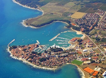
| imagetext= The bay and new marina of Novigrad - ''Click for larger view'' | | imagetext= The bay and new marina of Novigrad - ''Click for larger view'' | ||
| - | + | }} | |
{| class="infobox bordered" style="width: 28em; text-align: right; font-size: 90%;" | {| class="infobox bordered" style="width: 28em; text-align: right; font-size: 90%;" | ||
|- | |- | ||
| Line 140: | Line 142: | ||
{{Contributors|[[User:Lighthouse|Lighthouse]], [[User:Atheneoflymington|Athene of Lymington]]}} | {{Contributors|[[User:Lighthouse|Lighthouse]], [[User:Atheneoflymington|Athene of Lymington]]}} | ||
| - | |||
| - | |||
[[Category:Ports - Croatia]] [[Category:Anchorages - Croatia]] | [[Category:Ports - Croatia]] [[Category:Anchorages - Croatia]] | ||
Revision as of 10:27, 17 February 2016
| Novigrad
| |
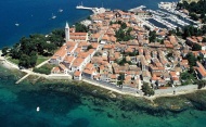
The town of Novigrad is the second harbour a yacht will encounter on crossing the border from Slovenia on the way south and a seasonal port of entry. It lies around nine miles S of the harbour and marina of Umag and seven miles N of the harbour of Porec. Built on a peninsula between two bays, the town was originally a Byzantine settlement, subsequently passing through the hands of the Lombards and Franks before becoming part of the Venetian republic by 1270. The period of Venetian rule lasted until the arrival of Napoleon’s troops in 1797, after which the whole of Istria passed under Austro-Hungarian control, which lasted except for a brief period of French rule in 1806-13 until 1918, when the area became part of the Kingdom of Italy. As with most of the towns along the Istrian coast, however, most of the remaining Italian population left in 1954 when the town was ceded to the new Federal Republic of Yugoslavia. With the breakup of Yugoslavia in 1991, Novigrad became part of the new Republic of Croatia. Today the town subsists mainly on agriculture and tourism and has retained much of its mediaeval layout, with narrow, winding lanes and substantial remains of its walls and fortifications. Tourism has been boosted by the creation on the E side of the bay of a new hotel and marina development, Marina Nautica, Novigrad, with 225 berths for yachts up to 40 metres in depths of 4.0 metres and 50 spaces on land. The town also has a smaller marina facility in its old harbour at the S end of the bay, Marina Laguna, which is only suitable for smaller yachts up to 12.0 metres and has depths of just over 1.5 metres.
Local Weather
Diurnal winds along the coast are mostly moderate during the summer months, predominantly from NW and rarely exceeding force 4/5. At night, katabatic winds off the mountains are a feature of some of the harbours along the NE Adriatic coast. During early spring and (especially) autumn conditions can be more unsettled, occasionally accompanied by violent thunderstorms - luckily of short duration - with winds of 30-35 knots or more and vicious, steep seas. In the winter the sudden, violent N wind off the mountains, the bora, is much to be feared.
Equally prevalent in winter - although not uncommon in summer - is the scirocco, a S/SE wind that blows up from North Africa, usually in advance of a depression moving E across the Mediterranean. Unlike the bora, the scirocco only occasionally exceeds gale force, but is still a phenomenon to be wary of, especially if on a lee coast.
For sources of weather forecasting, see Croatia.
Charts
- British Admiralty
- 1471
- 204
- 201
- Croatian charts
- 100-15
- 11
- Italian charts
- 924
- 39
- Imray Nautical Chart
- M24
Radio Nets
Also see World Cruiser's Nets.
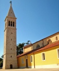
The bay of Novigrad is easily distinguished by the tall white belltower in the town on its peninsula at the S side of the bay and, closer in, an octagonal tower on the end of the outer breakwater. Approach should be made from WSW, heading for the centre of the bay and keeping at least half a mile off the coast, whether arriving from N or S. There are dangerous shoals inshore in the approach from both directions. For further directions, see individual berthing options.
Check-in facilities (for Customs and Immigration)
Yachts entering from Slovenia or Italy can clear in at the customs and immigration post on the inside of the pier 300 metres ENE of the outer breakwater.
Berthing options
Visiting yachts have four berthing options in Novigrad:
- Marina Nautica, Novigrad Template:Poi coord - Marina Nautica, Novigrad is a modern marina and leisure development, including a large hotel, constructed by the Nautica Hotels and Resorts Group. It lies on the E side of the bay of Novigrad and offers 225 berths for yachts up to 40 metres in depths of up to 4.0 metres. It can also accommodate around 50 yachts on land for winter storage. Click on link for details.
- Marina Laguna, Novigrad Template:Poi coord - Marina Laguna is effectively the old harbour of Novigrad, surrounded by the old town at the S end of the bay. It is entered via a very narrow channel with depths of as little as 1.6 metres, so is suitable only for shallow draft vessels. Inside the basin there are a total of 86 berths along the quays and a long central pier for yachts up to 12 metres. Maximum depths are 2.2 metres. There is water and electricity on the quays and pier and a small boatyard with a travel lift (35 T) and crane (10 T) and space for around 30 boats on land.
- Harbour breakwater - On the inside of the outer breakwater there is room for around 20 yachts to berth stern or bows-to the quay. Depths on the quay here are around 3.5 metres. You will need to use your anchor here. Berthing charges apply at 8 kuna/metre/day. There are no facilities on the quay. Shelter here is only moderate and the berths would become untenable in strong NW winds.
- Anchorage - There are a total of 10 mooring buoys in the bay just E of the outer breakwater which can be picked up by visitors. Others are usually in place in the bight at the N end of the bay. Depths are the buoys are 3.5 - 4.0 metres. Mooring charges are 4 kuna/metre/day. Alternatively, there may be room to free anchor in the bight, clear of the mooring buoys. Shelter here is better than on the quay, although strong W or SW winds make it very uncomfortable.
Marinas & Yacht Clubs
- Marina Nautica, Novigrad
- Marina Laguna, Novigrad (see above)
Anchorages
See above.
Offshore Islands and Groups
None.
Yacht Repairs and Services
Marine Stores
Submit addresses and contact details of marine related businesses that are of interest to cruisers.
Repairs/Yards
See entry for Marina Nautica for details.
Fuel, Water, & Electricity
Fuel dock at Marina Nautica. Water and electricity in Marina Nautica and at most berths in Marina Laguna. No facilities on harbour breakwater.
Tourism and Things to do Ashore
Tourism
The old town of Novigrad, like most of the former Venetian coastal towns in Istria, is well worth exploring. There are several good examples of typical Venetian houses from 15th and 16th centuries and substantial sections of the mediaeval town walls survive, especially on the south side of town. The Basilica of St. Pelagius with its prominent bell tower dates back as far as the 8th century, although the present church was completed in the 16th century on the foundations of the older building. Beneath the church is a late Romanesque crypt. Novigrad is also the closest harbour for a visit to the uniquely unspoilt mediaeval hilltop town of Motovun and the artists village of Groznjan 20 kilometres inland. The diversion is one not to be missed.
Grocery & Supply Stores
Good provisions shops in the town.
Eateries
Numerous bars and restaurants in the old town.
Internet/WiFi
None.
Laundry
In Marina Nautica.
Motorbike & Car Rentals
Rental outlets in the town.
Garbage Disposal
Bins in the marinas and near the breakwater.
Transportation
- Buses to Rijeka, Ljubljana and Zagreb
- International airports at Pula 70 kms, Trieste 75 kms and Ljubljana 110 kms.
Routes/Passages To/From
'See Croatia.
Cruiser's Friends
Contact details of "Cruiser's Friends" that can be contacted for local information or assistance.
Forum Discussions
List links to discussion threads on partnering forums. (see link for requirements)
External Links
- Novigrad at the Wikipedia
- Novigrad municipal website (Croatian and Italian only)
For other useful websites, see Croatia.
References & Publications
See entry for Croatia.
Personal Notes
Personal experiences?
Last Visited & Details Checked (and updated here)
Date of member's visit to this Port/Stop & this page's details validated:
- Data compiled from web research (please update if possible)--Athene of Lymington 13:13, 10 February 2011 (UTC)
| This page has an outline in place but needs completing. Please contribute if you can to help it grow further. Click on Comments to suggest further content or alternatively, if you feel confident to edit this page, click on the edit tab at the top and enter your changes directly. |
| |
|---|
|
Names: Lighthouse, Athene of Lymington |


