Otranto
From CruisersWiki
m |
m (Text replace - "#References & Publications|" to "#References|") |
||
| (34 intermediate revisions not shown) | |||
| Line 1: | Line 1: | ||
| - | + | {{IsPartOf|Mediterranean|Adriatic Sea|Italy|Adriatic Coast of Italy}} | |
| - | { | + | {{TOC block}} |
| - | + | ||
| - | + | ||
| - | | | + | |
| - | + | ||
| - | | | + | |
| - | + | ||
| - | + | ||
| - | + | ||
| - | + | ||
| - | + | ||
| - | + | ||
| - | + | ||
| - | + | ||
| - | + | ||
| - | The harbour of [http://en.wikipedia.org/wiki/Otranto Otranto] lies on the Adriatic coat of Italy 30 miles N of the ‘heel’ of the Italian peninsula, where the Ionian and Adriatic seas meet. | + | {{Infobox |
| + | | lat= 40.1495| lon=18.49179 | ||
| + | | name= Otranto | ||
| + | | portofentry= | ||
| + | | zoom= 15 | ||
| + | | chartlet = y | ||
| + | | image= OtrantoHarbour.jpg | ||
| + | | imagetext= Otranto harbour from S | ||
| + | | summary= The harbour of [http://en.wikipedia.org/wiki/Otranto '''Otranto'''] lies on the Adriatic coat of Italy 30 miles N of the ‘heel’ of the Italian peninsula, where the Ionian and Adriatic seas meet. Originally a Greek settlement, Otranto became a Roman port following the defeat of its Carthaginian allies during the Second Punic War (203 - 201 BC). Although the completion of the Via Appia to Brundisium (Brindisi) in 264 BC had turned the latter into Rome’s most important port of embarkation for the East, Otranto’s proximity to the province of Illyria on the eastern Adriatic coast made it at least as important during the Imperial period. The town and its strategically sited harbour subsequently passed through Byzantine and Norman hands. Its use as an embarkation point for generations of Crusaders made Otranto a target for the Ottoman rulers, who briefly captured the town in 1480 (when most of its inhabitants were slaughtered) and again in 1537. Traces of Otranto’s former occupiers are still to be found in the town, including a monumental Norman cathedral and the castle, rebuilt under Aragonese rule in the 15th century. Today, the harbour is a popular port of call for yachts cruising the Adriatic coast of Italy or crossing the Adriatic Sea en route to Greece or Croatia. | ||
| + | | notes= | ||
| + | | news= | ||
| + | }} | ||
==Charts== | ==Charts== | ||
| Line 27: | Line 24: | ||
: 189 | : 189 | ||
| - | == | + | ==Weather== |
| - | + | During the summer months, the prevailing winds in the Adriatic are light to moderate coastal sea breezes. In spring and autumn, northerly winds are more frequent and can quickly rise to near gale force, especially in the northern Adriatic, where the much-feared ''bora'' is caused by high pressure over the mountains to the NE coupled with low pressure over southern Italy. Fortunately, the fiercest ''bora'' is normally to be expected in the winter months. Thunderstorms are occasionally experienced in spring and especially autumn and can be accompanied by violent winds of gale force and above. Luckily they are rarely long-lasting. In the southern Adriatic, the ''scirocco'', a S/SE wind blowing up from North Africa which can last for several days, is more common. Unlike the ''bora'', which can arrive without warning, a ''scirocco'' tends to build in strength over 24-48 hours, sometimes reaching gale force (especially in winter). | |
| - | + | ||
| - | + | ||
| - | + | ||
| - | + | ||
| - | + | ||
| - | During the summer months the prevailing winds in the Adriatic are light to moderate coastal | + | |
Sources for weather information: | Sources for weather information: | ||
| - | * There is a continuous ( | + | * There is a continuous (computerized voice) weather forecast on VHF 68 - first in Italian and then followed with an English translation |
* The same forecast is given in Italian and English on VHF coastal stations following a notification on channel 16 | * The same forecast is given in Italian and English on VHF coastal stations following a notification on channel 16 | ||
* [http://en.wikipedia.org/wiki/Navtex Navtex] weather forecasts covering the Adriatic are broadcast from stations at Roma, Trieste, Kerkyra (Greece) and Split (Croatia) | * [http://en.wikipedia.org/wiki/Navtex Navtex] weather forecasts covering the Adriatic are broadcast from stations at Roma, Trieste, Kerkyra (Greece) and Split (Croatia) | ||
| + | {{hold horizontal}} | ||
| - | == | + | ==Passages== |
| - | + | ''See [[Adriatic_Sea#Passages|Adriatic]]''. | |
| - | == | + | ==Communication== |
| - | + | {{Green|Add here VHF channel for the coastguard, harbor masters. etc.}} | |
| + | * | ||
| - | + | ''Also see [[World MM Nets|World Cruiser's Nets]]''. | |
| - | + | ==Navigation== | |
| + | In the approach from S, the tower of Torre del’Orto on a headland at the S end of the bay is conspicuous. From N, the town and breakwater of the harbour are visible once clear of the rocky offshore islets at the northern end of the bay. The bay is protected by a single breakwater oriented NW/SE. Entrance is from NW, leaving the green buoy marking the inshore shallows at the SW corner of the bay to starboard. | ||
| - | + | ==Berthing== | |
| + | The harbour authorities, the Circomare Otranto, can be contacted on VHF channel 16. | ||
| - | + | On the SW side of the harbour are a series of five pontoons run by the yacht club, providing a total of 390 berths. Of these about 4 berths are allocated to yachts in transit. Visiting yachts usually berth on the end of the easternmost pontoon where directed. Maximum length on the pontoons 20 metres. Depths at the pontoons range from 2.0 metres inshore to 6.5 metres at the outer end. Laid moorings at all berths. Water on the pontoons. Toilets. Internet point. Shelter is good here in most conditions, especially with the recent extension of the breakwater, although strong NE winds send in a swell, which is more troublesome than dangerous. | |
| - | + | ||
| - | + | If the pontoons are full, moor to the quay at the root of the breakwater in front of the coastguard building. Depth 2.6 meters with laid moorings. | |
| - | + | ||
| - | + | Both the transit berths for the ''Legale Navale'' (Yacht Club) and the berths on the public quay are organized by Andrea. You can ring him on his mobile {{mob|39|339|799 8073}} and either he or Fabrizio will help you out. In April 2013 a berth on the public quay was €25 a night for 15m yacht | |
| - | + | ||
| - | + | In July 2016 neither of the above was contactable on the telephone numbers provided and we spent a night anchored in the inner harbour. The following day a rib came out and we were invited onto the quay. Beware securing to the rusty rings on the quay wall which ate through my 10mm warps. | |
| - | + | ||
| - | + | ||
| - | + | ||
| - | === | + | ===Marinas & Yacht Clubs=== |
| - | + | * [http://www.leganavale.it/strutture/otranto Lega Navale] | |
| - | ==== | + | ==Anchorages== |
| - | + | {{poi | lat= 40.15027| lon=18.48997 | |
| - | + | | type= anchorage | |
| + | | name=NW of Harbour | ||
| + | | altname= {{Magenta|Alernate name if any}} | ||
| + | | url = | ||
| + | | zoom= 16 | ||
| + | | image= | ||
| + | | imagetext= | ||
| + | | text= There is good space to anchor in 6.0 - 8.0 metres in the North West corner of the harbour provided there is no East in the wind. The holding is good in mud and weed. (It was a bit rolly but secure in gusts to 25 from the North.--[[User:Monterey|Monterey]] | ||
| + | }} | ||
| - | == | + | {{poi | lat= 39.99997| lon=18.42549 |
| - | ==== | + | | type= anchorage |
| - | + | | name=Castro Marina | |
| - | + | | altname= {{Magenta|Alernate name if any}} | |
| + | | url = | ||
| + | | zoom= 16 | ||
| + | | image= | ||
| + | | imagetext= | ||
| + | | text= Castro Marina 12 miles South of Otranto is a beautiful clear anchorage well protected from Northerlies. Good holding. Attractive grottos along the shoreline. Several restaurants ashore. | ||
| + | }} | ||
| - | + | ==Amenities== | |
| - | + | {{tlist | |
| - | + | ||
| - | + | ||
| - | + | ||
| - | + | ||
| - | + | |header|Facilities | |
| - | + | ||
| - | + | ||
| - | + | |Water| On the pontoons | |
| - | + | |Electricity| N/A (Not Available) | |
| - | + | |Toilets| In the harbour | |
| + | |Showers| {{MagentaText|?}} | ||
| + | |Laundry| N/A | ||
| + | |Garbage| Bins at the harbour | ||
| - | + | |header|Supplies | |
| - | + | |Fuel| Station on the quay (0800 - 1200 and 1500 - 1900) but not open every day outside high season (April 2013 was closed on Wednesdays). Depth at the fuel dock about 2m and you can go bows to the quay alongside a small finger ponton. | |
| + | |Bottled gas| {{MagentaText|?}} | ||
| + | |Chandlers| {{MagentaText|?}} | ||
| - | + | |header|Services | |
| - | + | |Repairs| Slipway. Travel lift (25 T). Fixed crane (45 T). Mobile crane. Engine, electrical and electronic repairs. Wood and fiberglass hull repairs. Divers. | |
| + | |Internet| WiFi in the harbour and in Internet cafes in the town | ||
| + | |Mobile connectivity| {{MagentaText|?}} | ||
| + | |Vehicle rentals| Rental outlets in the town | ||
| + | }} | ||
| - | == | + | ==Provisioning== |
| - | + | The nearest supermarket is about 1 km away. They advertise that they will deliver to your yacht. | |
| - | == | + | ==Eating out== |
| - | + | Numerous restaurants and pizzerias around the harbour and in the town. | |
| - | + | ==Transportation== | |
| - | * Buses to Rome via Lecce and Brindisi | + | * Buses to Rome via Lecce and [[Brindisi]] |
* Local and international flights from Brindisi airport | * Local and international flights from Brindisi airport | ||
* Train station with connections to Lecce and beyond | * Train station with connections to Lecce and beyond | ||
| - | * Hydrofoil to Corfu (July - mid-September) | + | * Hydrofoil to [[Corfu]] (July - mid-September) |
| - | == | + | ==Tourism== |
| - | + | The old town of Otranto is full of cobbled streets and squares and is deservedly popular with tourists during the summer. The 11th century Norman cathedral contains a forest of 42 marble pillars in its crypt, Byzantine frescoes on the walls and a magnificent 12th century mosaic pavement depicting the Tree of Life. More Byzantine frescoes are to be found in the small church of San Pietro. Close by the port is the 15th century Castello Aragonese, erected to protect the town following the disastrous Ottoman raid and massacre of 1480. From Otranto, it is also possible to catch a bus to Lecce, an inland town renowned for its superb Baroque architecture. Lecce boasts a number of magnificent baroque churches, Basilica di Santa Croce being the most ornamented of all, and an interesting cathedral and archbishop’s palace. Also in the town are the remains of a Roman amphitheatre and Roman theatre, the latter with a display of theatrical masks unearthed during various excavations. | |
| - | + | ||
| + | {{hgallery| | ||
| + | {{himage|OtrantoCathedral.jpg|Norman cathedral, Otranto }} | ||
| + | {{himage|OtrantoTown.jpg|Old town, Otranto}} | ||
| + | {{himage|OtrantoCastle.jpg|Castello Aragonese, Otranto}} | ||
| + | }} | ||
| - | == | + | ==Friends== |
Contact details of "Cruiser's Friends" that can be contacted for local information or assistance. | Contact details of "Cruiser's Friends" that can be contacted for local information or assistance. | ||
* | * | ||
| - | == | + | ==Forums== |
List links to discussion threads on [[Cruising Forums|partnering forums]]. (''see link for requirements'') | List links to discussion threads on [[Cruising Forums|partnering forums]]. (''see link for requirements'') | ||
* | * | ||
| - | == | + | ==Links== |
| - | + | * {{wikipedia}} | |
| - | * | + | * {{Wikivoyage}} |
| - | + | * [http://www.pagineazzurre.com/english/port/id_pug028/info_otranto.htm Otranto Pagine Azzurre] | |
* [http://www.pugliaevents.it/ Puglia region local events] | * [http://www.pugliaevents.it/ Puglia region local events] | ||
| - | ==References | + | ==References== |
| - | ''See [[Italy#References | + | ''See [[Italy#References|Italy]]''. |
| - | + | {{Comments}} | |
| - | + | * | |
| - | + | {{Verified by}} | |
| - | + | ||
* May 2004 --[[User:Atheneoflymington|Athene of Lymington]] 14:27, 23 December 2010 (UTC) | * May 2004 --[[User:Atheneoflymington|Athene of Lymington]] 14:27, 23 December 2010 (UTC) | ||
| - | * April 2013 -- Zebahdy of London | + | * April 2013 -- [[User:Zebahdy of London|Zebahdy of London]] |
| - | + | * June 2016 --[[User:Monterey|Monterey]] [[Image:Bermuda Icon.png]] | |
| - | + | * | |
| - | + | ||
| - | + | ||
| - | + | {{Page useable}} | |
| - | { | + | |
| - | + | ||
| - | + | ||
| - | + | ||
| - | + | ||
| - | + | ||
| - | + | ||
| - | |||
| - | |||
| - | |||
| - | |||
| - | |||
| - | |||
| + | {{Contributors| [[User:Lighthouse|Lighthouse]], [[User:Atheneoflymington|Athene of Lymington]], [[User:Zebahdy of London|Zebahdy of London]], [[User:Monterey|Monterey]]}} | ||
| - | [[Category:Ports - Italy]] | + | [[Category:Ports - Italy]] [[Category:Anchorages - Italy]] |
Latest revision as of 07:55, 21 August 2018
| Otranto
| |
| |
 Otranto harbour from S |
The harbour of Otranto lies on the Adriatic coat of Italy 30 miles N of the ‘heel’ of the Italian peninsula, where the Ionian and Adriatic seas meet. Originally a Greek settlement, Otranto became a Roman port following the defeat of its Carthaginian allies during the Second Punic War (203 - 201 BC). Although the completion of the Via Appia to Brundisium (Brindisi) in 264 BC had turned the latter into Rome’s most important port of embarkation for the East, Otranto’s proximity to the province of Illyria on the eastern Adriatic coast made it at least as important during the Imperial period. The town and its strategically sited harbour subsequently passed through Byzantine and Norman hands. Its use as an embarkation point for generations of Crusaders made Otranto a target for the Ottoman rulers, who briefly captured the town in 1480 (when most of its inhabitants were slaughtered) and again in 1537. Traces of Otranto’s former occupiers are still to be found in the town, including a monumental Norman cathedral and the castle, rebuilt under Aragonese rule in the 15th century. Today, the harbour is a popular port of call for yachts cruising the Adriatic coast of Italy or crossing the Adriatic Sea en route to Greece or Croatia.
Charts
- British Admiralty
- 187 Punta Stilo to Brindisi
- 188 Entrance To The Adriatic
- Italian charts
- 920
- 28
- 189
Weather
During the summer months, the prevailing winds in the Adriatic are light to moderate coastal sea breezes. In spring and autumn, northerly winds are more frequent and can quickly rise to near gale force, especially in the northern Adriatic, where the much-feared bora is caused by high pressure over the mountains to the NE coupled with low pressure over southern Italy. Fortunately, the fiercest bora is normally to be expected in the winter months. Thunderstorms are occasionally experienced in spring and especially autumn and can be accompanied by violent winds of gale force and above. Luckily they are rarely long-lasting. In the southern Adriatic, the scirocco, a S/SE wind blowing up from North Africa which can last for several days, is more common. Unlike the bora, which can arrive without warning, a scirocco tends to build in strength over 24-48 hours, sometimes reaching gale force (especially in winter).
Sources for weather information:
- There is a continuous (computerized voice) weather forecast on VHF 68 - first in Italian and then followed with an English translation
- The same forecast is given in Italian and English on VHF coastal stations following a notification on channel 16
- Navtex weather forecasts covering the Adriatic are broadcast from stations at Roma, Trieste, Kerkyra (Greece) and Split (Croatia)
Passages
See Adriatic.
Communication
Add here VHF channel for the coastguard, harbor masters. etc.
Also see World Cruiser's Nets.
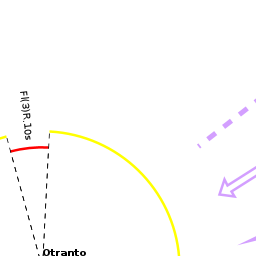
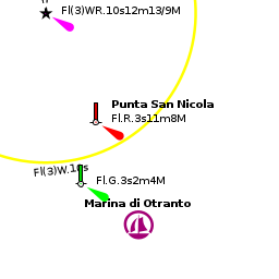
In the approach from S, the tower of Torre del’Orto on a headland at the S end of the bay is conspicuous. From N, the town and breakwater of the harbour are visible once clear of the rocky offshore islets at the northern end of the bay. The bay is protected by a single breakwater oriented NW/SE. Entrance is from NW, leaving the green buoy marking the inshore shallows at the SW corner of the bay to starboard.
Berthing
The harbour authorities, the Circomare Otranto, can be contacted on VHF channel 16.
On the SW side of the harbour are a series of five pontoons run by the yacht club, providing a total of 390 berths. Of these about 4 berths are allocated to yachts in transit. Visiting yachts usually berth on the end of the easternmost pontoon where directed. Maximum length on the pontoons 20 metres. Depths at the pontoons range from 2.0 metres inshore to 6.5 metres at the outer end. Laid moorings at all berths. Water on the pontoons. Toilets. Internet point. Shelter is good here in most conditions, especially with the recent extension of the breakwater, although strong NE winds send in a swell, which is more troublesome than dangerous.
If the pontoons are full, moor to the quay at the root of the breakwater in front of the coastguard building. Depth 2.6 meters with laid moorings.
Both the transit berths for the Legale Navale (Yacht Club) and the berths on the public quay are organized by Andrea. You can ring him on his mobile +39 (339) 799 8073 and either he or Fabrizio will help you out. In April 2013 a berth on the public quay was €25 a night for 15m yacht
In July 2016 neither of the above was contactable on the telephone numbers provided and we spent a night anchored in the inner harbour. The following day a rib came out and we were invited onto the quay. Beware securing to the rusty rings on the quay wall which ate through my 10mm warps.
Marinas & Yacht Clubs
Anchorages
NW of Harbour
Castro Marina
Amenities
| Facilities | |
|---|---|
| Water | On the pontoons |
| Electricity | N/A (Not Available) |
| Toilets | In the harbour |
| Showers | ? |
| Laundry | N/A |
| Garbage | Bins at the harbour |
| Supplies | |
| Fuel | Station on the quay (0800 - 1200 and 1500 - 1900) but not open every day outside high season (April 2013 was closed on Wednesdays). Depth at the fuel dock about 2m and you can go bows to the quay alongside a small finger ponton. |
| Bottled gas | ? |
| Chandlers | ? |
| Services | |
| Repairs | Slipway. Travel lift (25 T). Fixed crane (45 T). Mobile crane. Engine, electrical and electronic repairs. Wood and fiberglass hull repairs. Divers. |
| Internet | WiFi in the harbour and in Internet cafes in the town |
| Mobile connectivity | ? |
| Vehicle rentals | Rental outlets in the town |
Provisioning
The nearest supermarket is about 1 km away. They advertise that they will deliver to your yacht.
Eating out
Numerous restaurants and pizzerias around the harbour and in the town.
Transportation
- Buses to Rome via Lecce and Brindisi
- Local and international flights from Brindisi airport
- Train station with connections to Lecce and beyond
- Hydrofoil to Corfu (July - mid-September)
Tourism
The old town of Otranto is full of cobbled streets and squares and is deservedly popular with tourists during the summer. The 11th century Norman cathedral contains a forest of 42 marble pillars in its crypt, Byzantine frescoes on the walls and a magnificent 12th century mosaic pavement depicting the Tree of Life. More Byzantine frescoes are to be found in the small church of San Pietro. Close by the port is the 15th century Castello Aragonese, erected to protect the town following the disastrous Ottoman raid and massacre of 1480. From Otranto, it is also possible to catch a bus to Lecce, an inland town renowned for its superb Baroque architecture. Lecce boasts a number of magnificent baroque churches, Basilica di Santa Croce being the most ornamented of all, and an interesting cathedral and archbishop’s palace. Also in the town are the remains of a Roman amphitheatre and Roman theatre, the latter with a display of theatrical masks unearthed during various excavations.


Friends
Contact details of "Cruiser's Friends" that can be contacted for local information or assistance.
Forums
List links to discussion threads on partnering forums. (see link for requirements)
Links
- Otranto at the Wikipedia
- Otranto at the Wikivoyage
- Otranto Pagine Azzurre
- Puglia region local events
References
See Italy.
Comments
We welcome users' contributions to the Wiki. Please click on Comments to view other users' comments, add your own personal experiences or recommend any changes to this page following your visit.
Verified by
Date of member's last visit to Otranto and this page's details validated:
- May 2004 --Athene of Lymington 14:27, 23 December 2010 (UTC)
- April 2013 -- Zebahdy of London
- June 2016 --Monterey

| This is a usable page of the cruising guide. However, please contribute if you can to help it grow further. Click on Comments to add your personal notes on this page or to discuss its contents. Alternatively, if you feel confident to edit the page, click on the edit tab at the top and enter your changes directly. |
| |
|---|
|
Names: Lighthouse, Athene of Lymington, Zebahdy of London, Monterey |