Porto Santa Margherita
From CruisersWiki
m (bot: Removing Click) |
m (Text replace - "#References & Publications|" to "#References|") |
||
| (16 intermediate revisions not shown) | |||
| Line 1: | Line 1: | ||
{{IsPartOf|Mediterranean|Italy|Venice to Trieste}} | {{IsPartOf|Mediterranean|Italy|Venice to Trieste}} | ||
{{TOC block}} | {{TOC block}} | ||
| - | + | ||
| - | {{Infobox |45 | + | {{Infobox |
| + | | lat= 45.58548| lon=12.86817 | ||
| + | | name= Porto Santa Margherita | ||
| + | | portofentry= | ||
| zoom= 15 | | zoom= 15 | ||
| + | | chartlet = y | ||
| image= PortoSantaMargherita.jpg | | image= PortoSantaMargherita.jpg | ||
| imagetext= Porto Santa Margherita | | imagetext= Porto Santa Margherita | ||
| - | + | | summary= '''Porto Santa Margherita''' is a huge, purpose-built leisure development and marina complex at the mouth of the river Livenza on the Adriatic coast of [[Italy]] near the town of Caorle, eight miles NE of [[Cortellazzo]] and six miles SW of the entrance to [[Portobaseleghe]] on the Litoranea Veneta. The development contains a marina, [[Marina 4, Porto Santa Margherita|Marina 4]], and a further marina, [[Darsena dell’Orologio]], provides additional berthing 1400 metres up a side canal towards the town of Caorle. Between these the marinas they provide a total of 930 berths for yachts up to 22 metres. Depths over the bar at the river entrance are around 3.0 - 3.5 metres only at low water and entrance is inadvisable with draft of 2.0 metres or more except close to high water and in settled conditions. In any event, it is preferable to enter Porto Santa Margherita on a rising tide in case of silting. | |
| - | Porto Santa Margherita is a huge, purpose-built leisure development and marina complex at the mouth of the river Livenza on the Adriatic coast of [[Italy]] near the town of Caorle, eight miles NE of [[Cortellazzo]] and six miles SW of the entrance to [[Portobaseleghe]] on the Litoranea Veneta. | + | | notes= |
| + | | news= | ||
| + | }} | ||
| + | |||
| + | ==Charts== | ||
| + | ; British Admiralty | ||
| + | : 204 | ||
| + | ; Italian | ||
| + | : 924 | ||
| + | : 38 | ||
| - | == | + | ==Weather== |
| - | During the summer months the prevailing winds in the Adriatic are light to moderate coastal | + | During the summer months, the prevailing winds in the Adriatic are light to moderate coastal sea breezes. In spring and autumn, northerly winds are more frequent and can quickly rise to near gale force, especially in the northern Adriatic, where the much-feared “bora” is caused by high pressure over the mountains to the NE coupled with low pressure over southern Italy. Fortunately, the fiercest “bora” is normally to be expected in the winter months. Thunderstorms are occasionally experienced in spring and especially autumn and can be accompanied by violent winds of gale force and above. Luckily they are rarely long-lasting. Fog is a further hazard often encountered in the lagoon of Venice, especially in the early and late season. |
Sources for weather information: | Sources for weather information: | ||
| - | * There is a continuous ( | + | * There is a continuous (computerized voice) weather forecast on VHF 68 - first in Italian and then followed with an English translation |
* The same forecast is given in Italian and English on VHF coastal stations following a notification on channel 16 | * The same forecast is given in Italian and English on VHF coastal stations following a notification on channel 16 | ||
* Navtex weather forecasts covering the Adriatic are broadcast from stations at Roma, Trieste, Kerkyra (Greece) and Split (Croatia) | * Navtex weather forecasts covering the Adriatic are broadcast from stations at Roma, Trieste, Kerkyra (Greece) and Split (Croatia) | ||
| - | == | + | ==Passages== |
| - | + | ''See [[Aegean to West Mediterranean Passages]]''.* | |
| - | + | ||
| - | + | ||
| - | + | ||
| - | + | ||
| - | == | + | ==Communication== |
| + | {{Green|Add here VHF channel for the coastguard, harbor masters. etc.}} | ||
* | * | ||
''Also see [[World MM Nets|World Cruiser's Nets]]''. | ''Also see [[World MM Nets|World Cruiser's Nets]]''. | ||
| - | == | + | ==Navigation== |
| - | The entrance to the | + | The entrance to the {{mark | lat= 45.58548|lon=12.86817 |zoom=17| type= waypoint| name= river Livenza}} is protected by two 500-metre long converging breakwaters. The entrance is prone to silting and depths are currently (June 2015) around 3.0 - 3.5 metres at low water. Entry should therefore only be attempted close to high water and on a rising tide and never in strong onshore winds. Beware of the seasonal ferry (April - September) that exits the river at speed. [[Marina 4, Porto Santa Margherita|Marina 4]] is situated 400 metres upstream on the port side of the channel. Access is along a narrow channel through a pair of lock gates (used to maintain depths in the marina) with a width of 7.4 metres. For [[Darsena dell’Orologio]], take the right fork in the river 100 metres beyond Marina 4 into the Canale dell’Orologio and follow the channel for a further 1400 metres. The basin of Darsena dell’Orologio is to starboard, close to the town of Caorle and is accessed via a very narrow gate. |
| - | ==Berthing | + | ==Berthing== |
The two berthing options are in the marinas. | The two berthing options are in the marinas. | ||
===Marinas & Yacht Clubs=== | ===Marinas & Yacht Clubs=== | ||
| - | * [[Marina 4]] with 450 berths for yachts up to 22 metres in depths of 2.5 - 3.5 metres, and | + | * [[Marina 4, Porto Santa Margherita|Marina 4]] with 450 berths for yachts up to 22 metres in depths of 2.5 - 3.5 metres, and |
* [[Darsena dell’Orologio]] with 480 berths for yachts up to 20 metres in depths of 3.0 metres | * [[Darsena dell’Orologio]] with 480 berths for yachts up to 20 metres in depths of 3.0 metres | ||
| - | + | ==Anchorages== | |
| - | + | ||
| - | + | ||
Anchoring in the river is not recommended. | Anchoring in the river is not recommended. | ||
| - | == | + | ==Amenities== |
| - | + | {{tlist | |
| - | + | |header|Facilities | |
| - | + | ||
| - | + | ||
| - | + | ||
| - | + | |Water| In [[Marina 4, Porto Santa Margherita|Marina 4]] and [[Darsena dell’Orologio]] | |
| - | + | |Electricity| In [[Marina 4, Porto Santa Margherita|Marina 4]] and [[Darsena dell’Orologio]] | |
| + | |Toilets| In [[Marina 4, Porto Santa Margherita|Marina 4]] and [[Darsena dell’Orologio]] | ||
| + | |Showers| In [[Marina 4, Porto Santa Margherita|Marina 4]] and [[Darsena dell’Orologio]] | ||
| + | |Laundry| In [[Marina 4, Porto Santa Margherita|Marina 4]] | ||
| + | |Garbage| Bins in [[Marina 4, Porto Santa Margherita|Marina 4]] and [[Darsena dell’Orologio]] | ||
| - | + | |header|Supplies | |
| - | + | |Fuel|Station in [[Marina 4, Porto Santa Margherita|Marina 4]] | |
| + | |Bottled gas| {{MagentaText|?}} | ||
| + | |Chandlers| Near [[Marina 4, Porto Santa Margherita|Marina 4]] | ||
| - | + | |header|Services | |
| - | + | |Repairs| | |
| - | + | * [[Marina 4, Porto Santa Margherita|Marina 4]] - Boatyard equipped with Travel lift (40 T) is, flanked by a crane for hauling and various boats lighter and spars or others who need lifting up to 6,000 kg, as well as three bridge cranes from 5, 10 and 12 tons in the three sheds service | |
| - | + | * [[Darsena dell’Orologio]] - Small hard standing area. Mobile crane (20 T). Engine, electrical and electronic repairs. Wood, steel, and fiberglass hull repairs. Sail repairs. Divers | |
| - | + | |Internet| WiFi in [[Marina 4, Porto Santa Margherita|Marina 4]] (a charge is made) | |
| - | + | |Mobile connectivity| {{MagentaText|?}} | |
| - | Porto Santa Margherita is | + | |Vehicle rentals| |
| + | * Free bicycles in [[Darsena dell’Orologio]] | ||
| + | * Rental outlets in Porto Santa Margherita and Caorle | ||
| + | }} | ||
| - | == | + | ==Provisioning== |
| - | * Supermarket and good provisions shops close to Marina 4 | + | * Supermarket and good provisions shops close to [[Marina 4, Porto Santa Margherita|Marina 4]] |
* Provisions shops 10-15minutes from [[Darsena dell’Orologio]] | * Provisions shops 10-15minutes from [[Darsena dell’Orologio]] | ||
| - | == | + | ==Eating out== |
* Numerous bars and restaurants in Porto Margherita | * Numerous bars and restaurants in Porto Margherita | ||
* Huge choice in old town of Caorle | * Huge choice in old town of Caorle | ||
* Ristorante Antico Petronia in old town is highly recommended for seafood pasta. --[[User:Atheneoflymington|Athene of Lymington]] | * Ristorante Antico Petronia in old town is highly recommended for seafood pasta. --[[User:Atheneoflymington|Athene of Lymington]] | ||
| - | == | + | ==Transportation== |
| - | + | A ferry shuttle operates to carry cars and foot passengers across the river between Porto Margherita and Caorle from 0730 to 2200. | |
| - | ==== | + | ==Tourism== |
| - | + | {{Image right| CaorleCathedral.JPG| Caorle cathedral has an 11th century belltower }} | |
| + | {{Image right| CaorleOldTown.JPG| The old town of Caorle is fully pedestrianised }} | ||
| + | {{Image right| CaorleBeach.JPG| Caorle boasts miles of beaches }} | ||
| - | + | Porto Santa Margherita is essentially a huge leisure development and, although well provided with shops, has very little of tourist interest. However, the old town of Caorle is more historic and is a pleasant 30-45 minute walk from [[Marina 4, Porto Santa Margherita|Marina 4]] along the canalised river or 25 minutes along the seafront. | |
| - | + | ||
| - | + | [[Darsena dell’Orologio]] is to the N of the old town, about 10-15 minutes walk. | |
| - | + | ||
| - | + | The 11th century cathedral of Caorle has an unusual cylindrical belltower and some notable paintings from the Venetian school. At the end of the beach is the charming little church of Santuario della Madonna dell'Angelo, built to house a statue of the Virgin caught in their nets by a group of fishermen in the 7th century. | |
| - | + | ||
| - | + | ||
| - | + | ||
| - | + | ||
| - | + | ||
| - | == | + | ==Friends== |
Contact details of "Cruiser's Friends" that can be contacted for local information or assistance. | Contact details of "Cruiser's Friends" that can be contacted for local information or assistance. | ||
* | * | ||
| - | == | + | ==Forums== |
List links to discussion threads on [[Cruising Forums|partnering forums]]. (''see link for requirements'') | List links to discussion threads on [[Cruising Forums|partnering forums]]. (''see link for requirements'') | ||
* | * | ||
| - | == | + | ==Links== |
| - | * | + | * {{Wikipedia|Caorle|Caorle}} |
* | * | ||
| - | ==References | + | ==References== |
| - | ''See [[Italy#References | + | ''See [[Italy#References|Italy]]''. |
| - | {{Comments | + | {{Comments}} |
| + | * | ||
| - | + | {{Verified by}} | |
| - | + | ||
* June 2015 --[[User:Atheneoflymington|Athene of Lymington]] | * June 2015 --[[User:Atheneoflymington|Athene of Lymington]] | ||
* | * | ||
Latest revision as of 07:57, 21 August 2018
| Porto Santa Margherita
| |
| |
 Porto Santa Margherita |
Porto Santa Margherita is a huge, purpose-built leisure development and marina complex at the mouth of the river Livenza on the Adriatic coast of Italy near the town of Caorle, eight miles NE of Cortellazzo and six miles SW of the entrance to Portobaseleghe on the Litoranea Veneta. The development contains a marina, Marina 4, and a further marina, Darsena dell’Orologio, provides additional berthing 1400 metres up a side canal towards the town of Caorle. Between these the marinas they provide a total of 930 berths for yachts up to 22 metres. Depths over the bar at the river entrance are around 3.0 - 3.5 metres only at low water and entrance is inadvisable with draft of 2.0 metres or more except close to high water and in settled conditions. In any event, it is preferable to enter Porto Santa Margherita on a rising tide in case of silting.
Charts
- British Admiralty
- 204
- Italian
- 924
- 38
Weather
During the summer months, the prevailing winds in the Adriatic are light to moderate coastal sea breezes. In spring and autumn, northerly winds are more frequent and can quickly rise to near gale force, especially in the northern Adriatic, where the much-feared “bora” is caused by high pressure over the mountains to the NE coupled with low pressure over southern Italy. Fortunately, the fiercest “bora” is normally to be expected in the winter months. Thunderstorms are occasionally experienced in spring and especially autumn and can be accompanied by violent winds of gale force and above. Luckily they are rarely long-lasting. Fog is a further hazard often encountered in the lagoon of Venice, especially in the early and late season.
Sources for weather information:
- There is a continuous (computerized voice) weather forecast on VHF 68 - first in Italian and then followed with an English translation
- The same forecast is given in Italian and English on VHF coastal stations following a notification on channel 16
- Navtex weather forecasts covering the Adriatic are broadcast from stations at Roma, Trieste, Kerkyra (Greece) and Split (Croatia)
Passages
See Aegean to West Mediterranean Passages.*
Communication
Add here VHF channel for the coastguard, harbor masters. etc.
Also see World Cruiser's Nets.
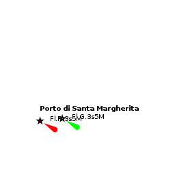
The entrance to the ![]() river Livenza [[Porto Santa Margherita#river Livenza|river Livenza]] 45°35.129'N, 012°52.090'E is protected by two 500-metre long converging breakwaters. The entrance is prone to silting and depths are currently (June 2015) around 3.0 - 3.5 metres at low water. Entry should therefore only be attempted close to high water and on a rising tide and never in strong onshore winds. Beware of the seasonal ferry (April - September) that exits the river at speed. Marina 4 is situated 400 metres upstream on the port side of the channel. Access is along a narrow channel through a pair of lock gates (used to maintain depths in the marina) with a width of 7.4 metres. For Darsena dell’Orologio, take the right fork in the river 100 metres beyond Marina 4 into the Canale dell’Orologio and follow the channel for a further 1400 metres. The basin of Darsena dell’Orologio is to starboard, close to the town of Caorle and is accessed via a very narrow gate.
river Livenza [[Porto Santa Margherita#river Livenza|river Livenza]] 45°35.129'N, 012°52.090'E is protected by two 500-metre long converging breakwaters. The entrance is prone to silting and depths are currently (June 2015) around 3.0 - 3.5 metres at low water. Entry should therefore only be attempted close to high water and on a rising tide and never in strong onshore winds. Beware of the seasonal ferry (April - September) that exits the river at speed. Marina 4 is situated 400 metres upstream on the port side of the channel. Access is along a narrow channel through a pair of lock gates (used to maintain depths in the marina) with a width of 7.4 metres. For Darsena dell’Orologio, take the right fork in the river 100 metres beyond Marina 4 into the Canale dell’Orologio and follow the channel for a further 1400 metres. The basin of Darsena dell’Orologio is to starboard, close to the town of Caorle and is accessed via a very narrow gate.
Berthing
The two berthing options are in the marinas.
Marinas & Yacht Clubs
- Marina 4 with 450 berths for yachts up to 22 metres in depths of 2.5 - 3.5 metres, and
- Darsena dell’Orologio with 480 berths for yachts up to 20 metres in depths of 3.0 metres
Anchorages
Anchoring in the river is not recommended.
Amenities
| Facilities | |
|---|---|
| Water | In Marina 4 and Darsena dell’Orologio |
| Electricity | In Marina 4 and Darsena dell’Orologio |
| Toilets | In Marina 4 and Darsena dell’Orologio |
| Showers | In Marina 4 and Darsena dell’Orologio |
| Laundry | In Marina 4 |
| Garbage | Bins in Marina 4 and Darsena dell’Orologio |
| Supplies | |
| Fuel | Station in Marina 4 |
| Bottled gas | ? |
| Chandlers | Near Marina 4 |
| Services | |
| Repairs |
|
| Internet | WiFi in Marina 4 (a charge is made) |
| Mobile connectivity | ? |
| Vehicle rentals |
|
Provisioning
- Supermarket and good provisions shops close to Marina 4
- Provisions shops 10-15minutes from Darsena dell’Orologio
Eating out
- Numerous bars and restaurants in Porto Margherita
- Huge choice in old town of Caorle
- Ristorante Antico Petronia in old town is highly recommended for seafood pasta. --Athene of Lymington
Transportation
A ferry shuttle operates to carry cars and foot passengers across the river between Porto Margherita and Caorle from 0730 to 2200.
Tourism


Porto Santa Margherita is essentially a huge leisure development and, although well provided with shops, has very little of tourist interest. However, the old town of Caorle is more historic and is a pleasant 30-45 minute walk from Marina 4 along the canalised river or 25 minutes along the seafront.
Darsena dell’Orologio is to the N of the old town, about 10-15 minutes walk.
The 11th century cathedral of Caorle has an unusual cylindrical belltower and some notable paintings from the Venetian school. At the end of the beach is the charming little church of Santuario della Madonna dell'Angelo, built to house a statue of the Virgin caught in their nets by a group of fishermen in the 7th century.
Friends
Contact details of "Cruiser's Friends" that can be contacted for local information or assistance.
Forums
List links to discussion threads on partnering forums. (see link for requirements)
Links
- Caorle at the Wikipedia
References
See Italy.
Comments
We welcome users' contributions to the Wiki. Please click on Comments to view other users' comments, add your own personal experiences or recommend any changes to this page following your visit.
Verified by
Date of member's last visit to Porto Santa Margherita and this page's details validated:
- June 2015 --Athene of Lymington
| This is a usable page of the cruising guide. However, please contribute if you can to help it grow further. Click on Comments to add your personal notes on this page or to discuss its contents. Alternatively, if you feel confident to edit the page, click on the edit tab at the top and enter your changes directly. |
| |
|---|
|
Names: Athene of Lymington |