Rogač
From CruisersWiki
(Created page with "==Rogac, Croatia== {| class="infobox bordered" style="width: 27em; text-align: left; font-size: 90%;" |- |- | colspan="2" style="text-align:center; font-size: smaller;" | {{Small...") |
Istioploos (Talk | contribs) m (Cosmetic) |
||
| Line 21: | Line 21: | ||
The small harbour of Rogac is situated roughly half way along the NE-facing coast of the island of [[Solta]] in [[Croatia]], facing the mainland town of [[Split]] 10 miles NE. The harbour consists of a small, V-shaped inlet on the W side of a larger bay, quayed around its head. Visiting yachts moor stern or bows-to on the quays on the N and S sides of the harbour, using the laid moorings provided. The inlet is protected in winds from most directions but is exposed in winds from N and NE. During busy periods, there is often little room for visiting yachts arriving late in the day. | The small harbour of Rogac is situated roughly half way along the NE-facing coast of the island of [[Solta]] in [[Croatia]], facing the mainland town of [[Split]] 10 miles NE. The harbour consists of a small, V-shaped inlet on the W side of a larger bay, quayed around its head. Visiting yachts moor stern or bows-to on the quays on the N and S sides of the harbour, using the laid moorings provided. The inlet is protected in winds from most directions but is exposed in winds from N and NE. During busy periods, there is often little room for visiting yachts arriving late in the day. | ||
| + | |||
[[Image:RogacAerial.jpg|thumb|345px|right| '''Rogac harbour from WSW''' <br />''Click for larger view'' ]] | [[Image:RogacAerial.jpg|thumb|345px|right| '''Rogac harbour from WSW''' <br />''Click for larger view'' ]] | ||
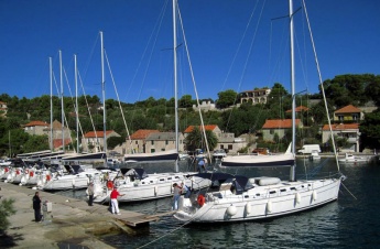
[[Image:RogacQuay.jpg|thumb|345px|right| '''Yachts berthed on Rogac S quay''' <br />''Click for larger view'' ]] | [[Image:RogacQuay.jpg|thumb|345px|right| '''Yachts berthed on Rogac S quay''' <br />''Click for larger view'' ]] | ||
| Line 52: | Line 53: | ||
==Anchorages== | ==Anchorages== | ||
| - | The nearest suitable anchorage is U. Necujam (See [[Solta]] island page). | + | The nearest suitable anchorage is U. Necujam (''See [[Solta]] island page''). |
====Fuel, Water, & Electricity==== | ====Fuel, Water, & Electricity==== | ||
| Line 60: | Line 61: | ||
====Tourism==== | ====Tourism==== | ||
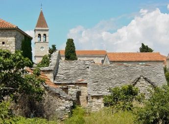
The village of Grohote two kilometers uphill to the SW is worth the hike. Dating back to the 14th century, it is the oldest village on the island and Roman remains discovered nearby suggest an even older history. The village still retains many of its mediaeval streets and old stone houses. | The village of Grohote two kilometers uphill to the SW is worth the hike. Dating back to the 14th century, it is the oldest village on the island and Roman remains discovered nearby suggest an even older history. The village still retains many of its mediaeval streets and old stone houses. | ||
| + | |||
[[Image:SoltaGrohote.jpg|thumb|345px|right| '''Grohote on Solta''' <br />''Click for larger view'' ]] | [[Image:SoltaGrohote.jpg|thumb|345px|right| '''Grohote on Solta''' <br />''Click for larger view'' ]] | ||
| Line 76: | Line 78: | ||
====Transportation==== | ====Transportation==== | ||
* Ferries to [[Split]]. | * Ferries to [[Split]]. | ||
| - | * Airport near Trogir. | + | * Airport near [[Trogir]]. |
==Cruiser's Friends== | ==Cruiser's Friends== | ||
Contact details of "Cruiser's Friends" that can be contacted for local information or assistance. | Contact details of "Cruiser's Friends" that can be contacted for local information or assistance. | ||
* | * | ||
| + | |||
==Forum Discussions== | ==Forum Discussions== | ||
List links to discussion threads on [[Cruising Forums|partnering forums]]. (see link for requirements) | List links to discussion threads on [[Cruising Forums|partnering forums]]. (see link for requirements) | ||
* | * | ||
| + | |||
==External Links== | ==External Links== | ||
| - | See [[Croatia]]. | + | See [[Croatia#External Links|Croatia]]. |
==References & Publications== | ==References & Publications== | ||
| Line 94: | Line 98: | ||
* | * | ||
| - | ====Last Visited & Details Checked (and updated here) | + | ====Last Visited & Details Checked (and updated here)==== |
''Date of member's visit to this Port/Stop & this page's details validated'': | ''Date of member's visit to this Port/Stop & this page's details validated'': | ||
* August 2005 --[[User:Atheneoflymington|Athene of Lymington]] 17:27, 23 April 2012 (BST) | * August 2005 --[[User:Atheneoflymington|Athene of Lymington]] 17:27, 23 April 2012 (BST) | ||
| + | |||
{{Guide2}} | {{Guide2}} | ||
| + | |||
<br /> | <br /> | ||
Revision as of 23:42, 11 December 2012
Rogac, Croatia
| | |
| | 43°23.68′N, 16°18.39′E |
|---|---|
| | Photo gallery |
| | Local chartlet |
The small harbour of Rogac is situated roughly half way along the NE-facing coast of the island of Solta in Croatia, facing the mainland town of Split 10 miles NE. The harbour consists of a small, V-shaped inlet on the W side of a larger bay, quayed around its head. Visiting yachts moor stern or bows-to on the quays on the N and S sides of the harbour, using the laid moorings provided. The inlet is protected in winds from most directions but is exposed in winds from N and NE. During busy periods, there is often little room for visiting yachts arriving late in the day.
Click for larger view
Charts
- British Admiralty
- 2712
- Croatian charts
- MK16
- Imray
- M26 (Rogoznica - Split)
Local Weather
Diurnal winds among the islands are mostly moderate during the summer months, predominantly from NW and rarely exceeding force 4/5, although gusting is common in narrow channels between islands and on the lee side of headlands. At night, katabatic winds off the mountains affect some of the islands close to the mainland coast. During early spring and (especially) autumn conditions can be more unsettled, occasionally accompanied by violent thunderstorms - luckily of short duration - with winds of 30-35 knots or more and vicious, steep seas. In the winter the sudden, violent N wind off the mountains, the bora, is much to be feared, especially along the coast from Rijeka down to Zadar, although its effects can be felt as far south as Split.
Equally prevalent in winter - although not uncommon in summer - is the scirocco, a S/SE wind that blows up from North Africa, usually in advance of a depression moving E across the Mediterranean. Unlike the bora, the scirocco only occasionally exceeds gale force, but is still a phenomenon to be wary of, especially if on a lee coast.
For sources of weather forecasting, see Croatia.
There are no dangers in the immediate approach to Luka Muna, although the headland on the E side of the entrance is shallow for around 50 metres off. Depths in the harbour entrance are 10 - 12 metres and on the quays 4.0 - 5.0 metres.
Check-in facilities (for Customs and Immigration)
Split is the nearest all-year round port of entry. During the summer, Hvar and, if arriving from N, Primosten on the mainland are also ports of entry.
Berthing options
Yachts moor stern or bows-to the quays on either the N or S side of the inlet, past the ferry quay to starboard on entry. Depths at the quays vary from 3.0 - 4.0 metres on the N side to 5.0 - 6.0 metres on the S side. There are laid lines at both quays. Water and electricity points provided. Shelter on both quays is good in all conditions except with strong N or NE winds, when a heavy swell enters.
Marinas & Yacht Clubs
None.
Anchorages
The nearest suitable anchorage is U. Necujam (See Solta island page).
Fuel, Water, & Electricity
Fuel berth next to ferry quay. Water and electricity on both N and S quays.
Things to do Ashore
Tourism
The village of Grohote two kilometers uphill to the SW is worth the hike. Dating back to the 14th century, it is the oldest village on the island and Roman remains discovered nearby suggest an even older history. The village still retains many of its mediaeval streets and old stone houses.
Grocery & Supply Stores
Two supermarkets and other provisions shops in Grohote.
Eateries
- Restaurant and café/bar at the harbour.
Internet/WiFi
None.
Garbage Disposal
Bins near the harbour.
Transportation
Cruiser's Friends
Contact details of "Cruiser's Friends" that can be contacted for local information or assistance.
Forum Discussions
List links to discussion threads on partnering forums. (see link for requirements)
External Links
See Croatia.
References & Publications
See Croatia.
Personal Notes
Personal experiences?
Last Visited & Details Checked (and updated here)
Date of member's visit to this Port/Stop & this page's details validated:
- August 2005 --Athene of Lymington 17:27, 23 April 2012 (BST)
|
|---|
|
Names: Athene of Lymington |
| |
|---|
| | HOMEPAGE | Wiki Contents | Croatia | Solta | Rogac | |

