Sea-Cortez
From CruisersWiki
Lighthouse (Talk | contribs) (→Radio Nets) |
Lighthouse (Talk | contribs) |
||
| Line 3: | Line 3: | ||
===Background=== | ===Background=== | ||
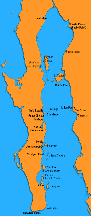
| - | + | The ''Gulf of California'' (also known as the '''Sea of Cortez''' or Sea of Cortés; locally known in the Spanish language as ''Mar de Cortés'' or ''Mar Bermejo'' or ''Golfo de California'') is a body of water that separates the Baja California Peninsula from the Mexican mainland. It is bordered by the states of Baja California, Baja California Sur, Sonora, and Sinaloa. The name "Gulf of California" predominates on most maps in English today. The name '''"Sea of Cortés"''' is the one preferred by most local residents. The Gulf is believed by many to have opened up 5.3 million years ago, redirecting the flow of the Colorado River. Other rivers which also flow into the Gulf of California include the Fuerte, Mayo, Sinaloa, Sonora, and the Yaqui. Its surface area is about 160,000 km² (62,000 square miles). | |
===Charts=== | ===Charts=== | ||
Revision as of 14:56, 14 December 2008
Sea of Cortez
Background
The Gulf of California (also known as the Sea of Cortez or Sea of Cortés; locally known in the Spanish language as Mar de Cortés or Mar Bermejo or Golfo de California) is a body of water that separates the Baja California Peninsula from the Mexican mainland. It is bordered by the states of Baja California, Baja California Sur, Sonora, and Sinaloa. The name "Gulf of California" predominates on most maps in English today. The name "Sea of Cortés" is the one preferred by most local residents. The Gulf is believed by many to have opened up 5.3 million years ago, redirecting the flow of the Colorado River. Other rivers which also flow into the Gulf of California include the Fuerte, Mayo, Sinaloa, Sonora, and the Yaqui. Its surface area is about 160,000 km² (62,000 square miles).
Charts
Submit the chart details that are required for safe navigation.
Radio Nets
See Mexico
Climate and Weather
Climate & general weather conditions?
Sources for weather forecast info:
Popular Routes/passages
Popular routes/passages, timing, etc.
Approach
Details?
Check-in facilities
See each "Port of Entry".
Customs & Immigration
See Mexico
Ports and Popular Stops
- La Paz (Port of entry)
Marinas & Yacht Clubs
Submit Marina details.
Anchorages
List details of all safe anchorages in the area.
Health & Security
?
Tourism & things to do ashore
List places of interest, tours, eateries, etc.
Marine stores
Submit addresses and contact details of marine related businesses that are of interest to cruisers.
Offshore Islands
List Islands
References & Publications
Publications, Guides, etc.
Cruiser's Friends
Contact details of "Cruiser's Friends" that can be contacted for local information or assistance.
Forum Discussions
List links to discussion threads on the Cruiser Log Forum
External Links
Links to relevant websites.
Personal Notes
Personal experiences?
.
