Senigallia
From CruisersWiki
Istioploos (Talk | contribs) (Chartlet) |
m (Text replace - "#References & Publications|" to "#References|") |
||
| (21 intermediate revisions not shown) | |||
| Line 1: | Line 1: | ||
| - | {| | + | {{IsPartOf|Mediterranean|Adriatic Sea|Italy|Adriatic Coast of Italy}} |
| - | | | + | {{TOC block}} |
| - | | | + | |
| - | + | {{Infobox | |
| - | + | | lat= 43.7221 | lon= 13.22108 | |
| - | + | | name= Senigallia | |
| - | + | | portofentry= | |
| - | + | | zoom= 16 | |
| - | + | | chartlet = y | |
| - | + | | image= | |
| - | + | | imagetext= {{Magenta|Map or Picture of port}} | |
| - | + | | summary= The port of [http://en.wikipedia.org/wiki/Senigallia Senegallia] is situated on the Adriatic coast of [[Italy]] around 14 miles NW of the port of [[Ancona]] and 12 miles SE of the harbour of [[Fano]]. The port, like many along this coast, was once entered via a canalized river, which is however now unused and closed to navigation due to silting. A separate entrance now leads to the three basins of the harbour immediately NW of the river mouth. The largest of the basins contains a relatively new, 300-berth marina which can accommodate yachts up to 18.0 metres. | |
| - | | | + | | notes= |
| - | | | + | | news= |
| - | + | }} | |
| - | | | + | |
| - | The port of [http://en.wikipedia.org/wiki/Senigallia Senegallia] is situated on the Adriatic coast of [[Italy]] around 14 miles NW of the port of [[Ancona]] and 12 miles SE of the harbour of [[Fano]]. | + | |
| - | + | ||
==Charts== | ==Charts== | ||
; British Admiralty | ; British Admiralty | ||
| Line 25: | Line 23: | ||
: 214 | : 214 | ||
| - | == | + | ==Weather== |
| - | + | During the summer months, the prevailing winds in the Adriatic are light to moderate coastal sea breezes. In spring and autumn, northerly winds are more frequent and can quickly rise to near gale force, especially in the northern Adriatic, where the much-feared “bora” is caused by high pressure over the mountains to the NE coupled with low pressure over southern Italy. Fortunately, the fiercest “bora” is normally to be expected in the winter months. Thunderstorms are occasionally experienced in spring and especially autumn and can be accompanied by violent winds of gale force and above. Luckily they are rarely long-lasting. In the southern Adriatic, the “Scirocco”, a S/SE wind blowing up from North Africa which can last for several days, is more common. Unlike the “bora”, which can arrive without warning, a “scirocco” tends to build in strength over 24-48 hours, sometimes reaching gale force (especially in winter). | |
| - | + | ||
| - | + | ||
| - | + | ||
| - | + | ||
| - | During the summer months the prevailing winds in the Adriatic are light to moderate coastal | + | |
Sources for weather information: | Sources for weather information: | ||
| - | * There is a continuous ( | + | * There is a continuous (computerized voice) weather forecast on VHF 68 - first in Italian and then followed with an English translation |
* The same forecast is given in Italian and English on VHF coastal stations following a notification on channel 16 | * The same forecast is given in Italian and English on VHF coastal stations following a notification on channel 16 | ||
* Navtex weather forecasts covering the Adriatic are broadcast from stations at Roma, Trieste, Kerkyra (Greece) and Split (Croatia) | * Navtex weather forecasts covering the Adriatic are broadcast from stations at Roma, Trieste, Kerkyra (Greece) and Split (Croatia) | ||
| - | == | + | ==Passages== |
| - | + | ''See [[Adriatic_Sea#Passages|Adriatic]]''. | |
| - | {{ | + | ==Communication== |
| + | {{Green|Add here VHF channel for the coastguard, harbor masters. etc.}} | ||
| + | * | ||
| - | + | ''Also see [[World MM Nets|World Cruiser's Nets]]''. | |
| - | + | ||
| - | == | + | ==Navigation== |
| - | + | The entrance to Senigallia Marina lies 150 metres NW of the entrance to the canal, with which it must not be confused. An extension of the W training wall of the canal curves round to protect the marina, which is entered from NW through two smaller outer basins. Depths in the entrance are ?? metres and in the marina itself ?? metres. | |
| - | + | {{Note}}Along this stretch of the Adriatic coast tidal ranges can exceed 1.0 metre at springs, so judging the tides right can make a significant difference to safe access in most of the shallower harbours. | |
| - | + | ||
| - | == | + | ==Berthing== |
| - | + | The only option for visiting yachts is to berth in the marina, which is located in the third and largest of the basins from the entrance and is managed by the local [[#Porto Di Senigallia|Gestiport]]. Price (July 2013): 40 euro per night for a 12 metre yacht. | |
| - | ==Yacht | + | ===Marinas & Yacht Clubs=== |
| + | {{poi | lat= 43.72171| lon=13.21973 | ||
| + | | type= marina | ||
| + | | name= Porto Di Senigallia | ||
| + | | altname= Gestiport | ||
| + | | url = http://www.portodellarovere.eu | ||
| + | | zoom= 17 | ||
| + | | portofentry= | ||
| + | | image= | ||
| + | | imagetext= | ||
| + | | text= There are 300 berths, of which 30 are reserved for vessels in transit. Maximum length 18.0 metres. Berthing is on four long piers or around the quays. Go stern or bow to where directed, using the laid lines provided. Water and electricity is available and included in the mooring price. WiFi. | ||
| + | : {{email|[email protected]}}; Tel/Fax: {{phone|39|071|792 9669}}; VHF channel 11 | ||
| + | : Address: Via della Darsena, 60019 - Senigallia (AN), Italy | ||
| + | : Hours: | ||
| + | : Prices: ''For the latest prices see [http://www.portodellarovere.eu/tariffe.html Price Listing]'' | ||
| + | }} | ||
| - | == | + | ==Anchorages== |
| - | + | No anchoring is permitted in the harbour. | |
| - | + | ||
| - | ==== | + | ==Amenities== |
| - | + | {{tlist | |
| - | + | ||
| - | + | |header|Facilities | |
| - | + | ||
| - | + | ||
| - | + | ||
| - | + | ||
| - | + | ||
| - | + | ||
| - | + | |Water| In the [[#Porto Di Senigallia|marina]] | |
| - | {{ | + | |Electricity| In the [[#Porto Di Senigallia|marina]] |
| - | {{ | + | |Toilets| {{MagentaText|?}} |
| + | |Showers| {{MagentaText|?}} | ||
| + | |Laundry| {{MagentaText|?}} | ||
| + | |Garbage| In the [[#Porto Di Senigallia|marina]] | ||
| - | + | |header|Supplies | |
| - | + | |Fuel| Fuel station on the quay | |
| + | |Bottled gas| {{MagentaText|?}} | ||
| + | |Chandlers| {{MagentaText|?}} | ||
| - | + | |header|Services | |
| - | * | + | |Repairs| |
| + | * Travel lift (40T) | ||
| + | * Some engine, electrical and electronic repairs | ||
| + | |Internet|WifI | ||
| + | * In the [[#Porto Di Senigallia|marina]] | ||
| + | * In local internet cafes in the town | ||
| + | |Mobile connectivity| {{MagentaText|?}} | ||
| + | |Vehicle rentals| {{MagentaText|?}} | ||
| + | }} | ||
| - | == | + | ==Provisioning== |
| - | + | {{Green|Give the names and locations of supermarkets, grocery stores, bakeries, etc.}} | |
| - | == | + | ==Eating out== |
| - | + | {{Green|Give the name of recommended restaurant, tavernas, pastry stores, etc.}} | |
| - | ==== | + | ==Transportation== |
| + | {{GreenText|List transportation (local and/or international.)}} | ||
* | * | ||
| - | |||
| - | |||
* | * | ||
| - | == | + | ==Tourism== |
| - | + | ====Places to Visit==== | |
| - | + | {{Image right| RoccaRoveresca.jpg| The Rocca Roveresca }} | |
| - | ==== | + | {{Image right| PalazzoCommunale.jpg| Town hall, Senigallia }} |
| - | {{ | + | |
| - | + | ||
| - | + | The town is one of the leading beach resorts along the Adriatic coast, with umbrella-strewn beaches extending for kilometres in either direction from the marina. The town has a long history and its architectural attractions include an imposing fortress defending the sea approaches, the Fortress Rocca Roveresca, several Renaissance palazzos and a 16th century town hall. A more recent attraction is the Rotonda a Mare, a restored pier once used as a concert hall and now an exhibition and conference centre. | |
| - | + | ||
| - | == | + | ==Friends== |
Contact details of "Cruiser's Friends" that can be contacted for local information or assistance. | Contact details of "Cruiser's Friends" that can be contacted for local information or assistance. | ||
* | * | ||
| - | == | + | ==Forums== |
List links to discussion threads on [[Cruising Forums|partnering forums]]. (''see link for requirements'') | List links to discussion threads on [[Cruising Forums|partnering forums]]. (''see link for requirements'') | ||
* | * | ||
| - | == | + | ==Links== |
* {{wikipedia}} | * {{wikipedia}} | ||
| + | * {{Wikivoyage}} | ||
* | * | ||
| - | ==References | + | ==References== |
| - | ''See [[Italy#References | + | ''See [[Italy#References|Italy]]''. |
| - | + | {{Comments}} | |
| - | + | ||
* | * | ||
| - | + | {{Verified by}} | |
| - | + | ||
* July 2013 --[[User:JeanF73|s/v Seatern]] 05:44, 16 October 2013 (BST) | * July 2013 --[[User:JeanF73|s/v Seatern]] 05:44, 16 October 2013 (BST) | ||
* | * | ||
| - | |||
{{Page useable}} | {{Page useable}} | ||
| - | |||
{{Contributors|[[User:JeanF73|s/v Seatern]], [[User:Atheneoflymington|Athene of Lymington]]}} | {{Contributors|[[User:JeanF73|s/v Seatern]], [[User:Atheneoflymington|Athene of Lymington]]}} | ||
| - | |||
| - | |||
[[Category:Ports - Italy]] [[Category:Marinas - Italy]] | [[Category:Ports - Italy]] [[Category:Marinas - Italy]] | ||
Latest revision as of 08:00, 21 August 2018
| Senigallia
| |
|
The port of Senegallia is situated on the Adriatic coast of Italy around 14 miles NW of the port of Ancona and 12 miles SE of the harbour of Fano. The port, like many along this coast, was once entered via a canalized river, which is however now unused and closed to navigation due to silting. A separate entrance now leads to the three basins of the harbour immediately NW of the river mouth. The largest of the basins contains a relatively new, 300-berth marina which can accommodate yachts up to 18.0 metres.
Charts
- British Admiralty
- 220
- Italian
- 923
- 36
- 214
Weather
During the summer months, the prevailing winds in the Adriatic are light to moderate coastal sea breezes. In spring and autumn, northerly winds are more frequent and can quickly rise to near gale force, especially in the northern Adriatic, where the much-feared “bora” is caused by high pressure over the mountains to the NE coupled with low pressure over southern Italy. Fortunately, the fiercest “bora” is normally to be expected in the winter months. Thunderstorms are occasionally experienced in spring and especially autumn and can be accompanied by violent winds of gale force and above. Luckily they are rarely long-lasting. In the southern Adriatic, the “Scirocco”, a S/SE wind blowing up from North Africa which can last for several days, is more common. Unlike the “bora”, which can arrive without warning, a “scirocco” tends to build in strength over 24-48 hours, sometimes reaching gale force (especially in winter).
Sources for weather information:
- There is a continuous (computerized voice) weather forecast on VHF 68 - first in Italian and then followed with an English translation
- The same forecast is given in Italian and English on VHF coastal stations following a notification on channel 16
- Navtex weather forecasts covering the Adriatic are broadcast from stations at Roma, Trieste, Kerkyra (Greece) and Split (Croatia)
Passages
See Adriatic.
Communication
Add here VHF channel for the coastguard, harbor masters. etc.
Also see World Cruiser's Nets.
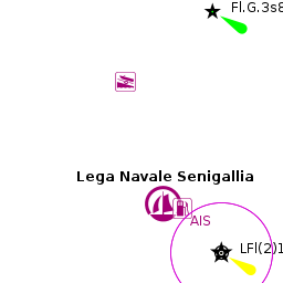
The entrance to Senigallia Marina lies 150 metres NW of the entrance to the canal, with which it must not be confused. An extension of the W training wall of the canal curves round to protect the marina, which is entered from NW through two smaller outer basins. Depths in the entrance are ?? metres and in the marina itself ?? metres.
Note: Along this stretch of the Adriatic coast tidal ranges can exceed 1.0 metre at springs, so judging the tides right can make a significant difference to safe access in most of the shallower harbours.
Berthing
The only option for visiting yachts is to berth in the marina, which is located in the third and largest of the basins from the entrance and is managed by the local Gestiport. Price (July 2013): 40 euro per night for a 12 metre yacht.
Marinas & Yacht Clubs
Porto Di Senigallia
There are 300 berths, of which 30 are reserved for vessels in transit. Maximum length 18.0 metres. Berthing is on four long piers or around the quays. Go stern or bow to where directed, using the laid lines provided. Water and electricity is available and included in the mooring price. WiFi.
- [email protected]; Tel/Fax: +39 (071) 792 9669; VHF channel 11
- Address: Via della Darsena, 60019 - Senigallia (AN), Italy
- Hours:
- Prices: For the latest prices see Price Listing
Anchorages
No anchoring is permitted in the harbour.
Amenities
| Facilities | |
|---|---|
| Water | In the marina |
| Electricity | In the marina |
| Toilets | ? |
| Showers | ? |
| Laundry | ? |
| Garbage | In the marina |
| Supplies | |
| Fuel | Fuel station on the quay |
| Bottled gas | ? |
| Chandlers | ? |
| Services | |
| Repairs |
|
| Internet | WifI
|
| Mobile connectivity | ? |
| Vehicle rentals | ? |
Provisioning
Give the names and locations of supermarkets, grocery stores, bakeries, etc.
Eating out
Give the name of recommended restaurant, tavernas, pastry stores, etc.
Transportation
List transportation (local and/or international.)
Tourism
Places to Visit


The town is one of the leading beach resorts along the Adriatic coast, with umbrella-strewn beaches extending for kilometres in either direction from the marina. The town has a long history and its architectural attractions include an imposing fortress defending the sea approaches, the Fortress Rocca Roveresca, several Renaissance palazzos and a 16th century town hall. A more recent attraction is the Rotonda a Mare, a restored pier once used as a concert hall and now an exhibition and conference centre.
Friends
Contact details of "Cruiser's Friends" that can be contacted for local information or assistance.
Forums
List links to discussion threads on partnering forums. (see link for requirements)
Links
- Senigallia at the Wikipedia
- Senigallia at the Wikivoyage
References
See Italy.
Comments
We welcome users' contributions to the Wiki. Please click on Comments to view other users' comments, add your own personal experiences or recommend any changes to this page following your visit.
Verified by
Date of member's last visit to Senigallia and this page's details validated:
- July 2013 --s/v Seatern 05:44, 16 October 2013 (BST)
| This is a usable page of the cruising guide. However, please contribute if you can to help it grow further. Click on Comments to add your personal notes on this page or to discuss its contents. Alternatively, if you feel confident to edit the page, click on the edit tab at the top and enter your changes directly. |
| |
|---|
|
Names: s/v Seatern, Athene of Lymington |