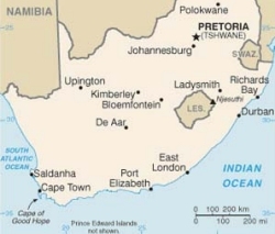
South Africa
From CruisersWiki
(Difference between revisions)
Lighthouse (Talk | contribs) (→Radio Nets) |
Lighthouse (Talk | contribs) |
||
| Line 35: | Line 35: | ||
* '''South Africa Maritime Mobile Net'''. S Africa. Covers Indian Ocean & S Atlantic. 14.316Mhz & moves to 7.045Mhz @ 0630hrs and also @ 1130hrs (both frequencies) | * '''South Africa Maritime Mobile Net'''. S Africa. Covers Indian Ocean & S Atlantic. 14.316Mhz & moves to 7.045Mhz @ 0630hrs and also @ 1130hrs (both frequencies) | ||
* '''Radio "Peri-Peri"'''. East Africa. Covers Indian Ocean & S Atlantic. 8.101Mhz @ 0500hrs zulu (weather) & then 12.353hz after the weather. Again (both freqs) @ 1500hrs zulu. | * '''Radio "Peri-Peri"'''. East Africa. Covers Indian Ocean & S Atlantic. 8.101Mhz @ 0500hrs zulu (weather) & then 12.353hz after the weather. Again (both freqs) @ 1500hrs zulu. | ||
| + | |||
| + | {| | ||
| + | | '''Station''' || '''VHF''' || '''Station''' || '''VHF''' | ||
| + | |- | ||
| + | | Kosi Bay<br> Sodwana<br>Cape st Lucia<br>Richards Bay<br>Bluff (Durban)<br>Port Shepstone<br>Port Edward<br>Port St Johns<br>Mazeppa Bay<br>East London<br>Governorskop<br>Port Elizabeth<br>Kareedouw<br>|| 01<br>03<br>25<br>28<br>26<br>26<br>27<br>24<br>28<br>26<br>83<br>25 or 27<br>24<br>|| more || more | ||
| + | |} | ||
===Ports & Anchorages=== | ===Ports & Anchorages=== | ||
Revision as of 12:08, 20 October 2007
Contents |
SOUTH AFRICA
| South Africa | |
 Flag | |
| Capital: | Pretoria |
|---|---|
| Language: | English, Afrikaans, others |
| Currency: | Rand |
| South Africa has 11 official languages. | |
Background
The "Cape of Good Hope" route is a wonderful alternative to the Red Sea route for circumnavigators. The passage between Durban and Cape Town has a reputation of being difficult and dangerous but cruisers who are armed with the right information and backed by excellent South African weather forecasting resources the passage can be extremely rewarding. South African yachts sail along this coast all the time, however, timing of the longer passages is important.
Customs and Immigration
See each Port.
Charts
See each sector.
See each sector.
Radio Nets
- South Africa Maritime Mobile Net. S Africa. Covers Indian Ocean & S Atlantic. 14.316Mhz & moves to 7.045Mhz @ 0630hrs and also @ 1130hrs (both frequencies)
- Radio "Peri-Peri". East Africa. Covers Indian Ocean & S Atlantic. 8.101Mhz @ 0500hrs zulu (weather) & then 12.353hz after the weather. Again (both freqs) @ 1500hrs zulu.
| Station | VHF | Station | VHF |
| Kosi Bay Sodwana Cape st Lucia Richards Bay Bluff (Durban) Port Shepstone Port Edward Port St Johns Mazeppa Bay East London Governorskop Port Elizabeth Kareedouw | 01 03 25 28 26 26 27 24 28 26 83 25 or 27 24 | more | more |
Ports & Anchorages
- Richards Bay
- Durban (Has data)
- East London
- Port Elizabeth
- Knysna
- Mossel Bay
- Simonstown & False Bay
- Hout Bay
- Cape Town
- Saldahna Bay
Passages
- Madagascar to Richards Bay/Durban
- Durban/Richards Bay to Madagascar
- Maputo to Richards Bay/Durban
- Durban/Richards Bay to Maputo
- Richards Bay to Cape Town
- Cape Town to Richards Bay
- South Africa to Australia (West to East and East to West)
- Atlantic Crossing (East to West)
- Atlantic Crossing (West to East)
Tourism & things to do
Supply details
Forum Discussions
List links to discussion threads on the Cruiser Log Forum
References & Publications
Publications, etc.
Cruisers "Friends"
See each sector.
External Links
Links to relevant websites.
.
