South Peloponnese
From CruisersWiki
m (→Koroni) |
Istioploos (Talk | contribs) (Chartlet) |
||
| Line 1: | Line 1: | ||
| - | |||
An online cruising guide for yachts sailing around South Peloponnese. | An online cruising guide for yachts sailing around South Peloponnese. | ||
| - | + | <imagemap> | |
| - | {{TOCleft}}The coast of southern [http://en.wikipedia.org/wiki/Peloponnese Peloponnese] is not usually visited by cruising yachts unless they are in transit either moving east to the [http://en.wikipedia.org/wiki/Aegean_Sea Aegean] or west on their way back. Yet, it is a beautiful coast with many interesting anchorages. | + | Image:Greece_S_PelopS.jpg|frame|center|<small>Satellite View of Southern Peloponnese - <em>For details click on a name or an area</em></small> |
| + | poly 514 1 517 43 567 42 569 1 [[Spetses]] | ||
| + | rect 464 38 533 71 [[Ports_of_NE_Peloponnese#Leonidio|Leonidio]] | ||
| + | rect 498 99 566 128 [[Ports_of_NE_Peloponnese#Kyparisi|Kyparisi]] | ||
| + | rect 535 164 600 191 [[Yerakas]] | ||
| + | rect 518 198 600 237 [[Monemvasia]] | ||
| + | poly 429 389 509 351 537 417 429 417 [[Cythera]] | ||
| + | poly 481 323 508 299 520 299 546 326 548 339 481 339 [[Elafonisos]] | ||
| + | rect 448 280 509 298 [[Elafonisos#Neapolis|Neapolis]] | ||
| + | rect 357 201 406 223 [[South_Peloponnese#Yithio|Yithio]] | ||
| + | rect 349 323 429 343 [[South_Peloponnese#Porto_Kayo|Porto Kayo]] | ||
| + | rect 251 320 334 342 [[South_Peloponnese#Yerolimenas|Yerolimenas]] | ||
| + | rect 253 269 308 289 [[South_Peloponnese#Mezapo|Mezapo]] | ||
| + | rect 296 237 335 253 [[South_Peloponnese#Diros|Diros]] | ||
| + | rect 251 217 310 235 [[South_Peloponnese#Limeni|Limeni]] | ||
| + | rect 180 64 257 107 [[South_Peloponnese#Kalamata (Port of Entry)|Kalamata]] | ||
| + | rect 152 98 223 135 [[South_Peloponnese#Petalidhi|Petalidhi]] | ||
| + | rect 153 159 209 180 [[South_Peloponnese#Koroni|Koroni]] | ||
| + | rect 110 172 167 195 [[South_Peloponnese#Methoni|Methoni]] | ||
| + | poly 94 189 113 202 136 241 60 241 60 225 [[South_Peloponnese#Sapienza|Sapienza]] | ||
| + | rect 67 113 123 149 [[Pylos]] | ||
| + | </imagemap>{{TOCleft}} | ||
| + | |||
| + | The coast of southern [http://en.wikipedia.org/wiki/Peloponnese Peloponnese] is not usually visited by cruising yachts unless they are in transit either moving east to the [http://en.wikipedia.org/wiki/Aegean_Sea Aegean] or west on their way back. Yet, it is a beautiful coast with many interesting anchorages. | ||
The coast is dominated by the three peninsulas: [http://en.wikipedia.org/wiki/Messinia Messinia] dominated by [http://en.wikipedia.org/wiki/Taygetus Mount Taygetos], [http://en.wikipedia.org/wiki/Mani_Peninsula Mani] ending into the capes Cavo Grosso and [http://en.wikipedia.org/wiki/Cape_Tainaron Tainaron], and finally the easternmost [http://en.wikipedia.org/wiki/Cape_Malea Cape Maleas]. | The coast is dominated by the three peninsulas: [http://en.wikipedia.org/wiki/Messinia Messinia] dominated by [http://en.wikipedia.org/wiki/Taygetus Mount Taygetos], [http://en.wikipedia.org/wiki/Mani_Peninsula Mani] ending into the capes Cavo Grosso and [http://en.wikipedia.org/wiki/Cape_Tainaron Tainaron], and finally the easternmost [http://en.wikipedia.org/wiki/Cape_Malea Cape Maleas]. | ||
| Line 50: | Line 72: | ||
===Ports=== | ===Ports=== | ||
====Methoni==== | ====Methoni==== | ||
| - | + | {{Infobox |36|48.89|N|21|42.47|E| | |
| - | + | | name= Methoni | |
| - | + | | mapzoom= 16 | |
| - | + | | image= Greece_Methoni_h.jpg | |
| - | + | | imagetext= Chart of Methoni - ''Click for larger view'' | |
| - | + | }} | |
| - | | | + | [http://en.wikipedia.org/wiki/Methoni%2C_Messenia Methoni] (Μεθώνη) is the site of a large [http://www.trivago.co.uk/methoni-127331/palace-castle/methoni-castle-196446 Venetian castle] and has a large natural harbor surrounded by the castle on one side and large sandy beaches on the other. The bay is only exposed to the SE winds. It is a spectacular site. It is believed that [http://en.wikipedia.org/wiki/Cervantes Cervantes] was imprisoned by the [http://en.wikipedia.org/wiki/Ottoman_Empire Ottomans] in the castle. The town is some distance from the castle and it is spread out. |
| - | + | ||
| - | | | + | |
| - | | | + | |
| - | + | ||
| - | + | ||
| - | | | + | |
| - | + | ||
| - | + | ||
Anchor to the N of of the old quay in 2-5 m depths. The bottom sand and mud, good holding. | Anchor to the N of of the old quay in 2-5 m depths. The bottom sand and mud, good holding. | ||
| Line 72: | Line 86: | ||
=====Last Visited & Details Checked (and updated here)===== | =====Last Visited & Details Checked (and updated here)===== | ||
''Date of member's visit to this Port/Stop & this page's details validated'': | ''Date of member's visit to this Port/Stop & this page's details validated'': | ||
| - | * June 2001 | + | * June 2001 {{Istioploos2}} |
* April 2014 --[[User:LifePart2|LifePart2]] [[Image:Canada_Icon.png]] | * April 2014 --[[User:LifePart2|LifePart2]] [[Image:Canada_Icon.png]] | ||
* | * | ||
| - | + | ||
| + | {{Image center|S_Peloponnese_Methoni.jpg |The Castle of Methoni |320px }} | ||
====Kalamata (Port of Entry)==== | ====Kalamata (Port of Entry)==== | ||
| - | + | {{Infobox |37|1.31|N|22|6.91|E| | |
| - | + | | name= Kalamata | |
| - | + | | mapzoom= 16 | |
| - | + | | image= S_Peloponnese_KalamataM.jpg | |
| - | + | | imagetext= he Marina of Kalamata - ''Click for larger view'' | |
| - | + | }} | |
| - | | | + | [http://en.wikipedia.org/wiki/Kalamata Kalamata] (Καλαμάτα) is the capital of the [http://en.wikipedia.org/wiki/Messinia Messinia] province. It is bustling modern city. It is a commercial harbor and it is always very busy. In the last few years a new modern [[Kalamata Marina|marina]] started operations. The marina provides all the usual conveniences and has a reputation of being very well ran. |
| - | + | ||
| - | | | + | |
| - | | | + | |
| - | + | ||
| - | + | ||
| - | | | + | |
| - | + | ||
| - | + | ||
If you do visit the marina, make sure you dock west of the entrance; the afternoon breeze creates a bit of a swell in the east part --[[User:Deltasig|Deltasig]] | If you do visit the marina, make sure you dock west of the entrance; the afternoon breeze creates a bit of a swell in the east part --[[User:Deltasig|Deltasig]] | ||
| Line 99: | Line 106: | ||
''Date of member's visit to this Port/Stop & this page's details validated'': | ''Date of member's visit to this Port/Stop & this page's details validated'': | ||
| - | * June 2001 | + | * June 2001 {{Istioploos2}} |
* July 2013 --[[User:Deltasig|Deltasig]] | * July 2013 --[[User:Deltasig|Deltasig]] | ||
| - | + | * | |
| + | {{hold vertical}} | ||
====Yithio==== | ====Yithio==== | ||
| - | + | {{Infobox |36|45.58|N|22|34.1|E| | |
| - | + | | name= Yithio | |
| - | + | | mapzoom= 16 | |
| - | + | | image= Greece_Yithio_h.jpg | |
| - | + | | imagetext= Chart of Yithio - ''Click for larger view'' | |
| - | + | }} | |
| - | | | + | Yíthio (Γύθιο) or Gythio is a very pleasant harbor and the main city of the [http://en.wikipedia.org/wiki/Mani_Peninsula Mani region]. It was the harbor of [http://en.wikipedia.org/wiki/Ancient_sparta Ancient Sparta]. |
| - | + | ||
| - | | | + | |
| - | | | + | |
| - | + | ||
| - | + | ||
| - | | | + | |
| - | + | ||
| - | + | ||
Yíthio is a good place to leave your yacht in order to visit [http://en.wikipedia.org/wiki/Sparta Sparta] and [http://en.wikipedia.org/wiki/Mystras Mystras]. | Yíthio is a good place to leave your yacht in order to visit [http://en.wikipedia.org/wiki/Sparta Sparta] and [http://en.wikipedia.org/wiki/Mystras Mystras]. | ||
| Line 126: | Line 126: | ||
=====Last Visited & Details Checked (and updated here)===== | =====Last Visited & Details Checked (and updated here)===== | ||
''Date of member's visit to this Port/Stop & this page's details validated'': | ''Date of member's visit to this Port/Stop & this page's details validated'': | ||
| - | * 1995 | + | * 1995 {{Istioploos2}} |
* | * | ||
===Marinas & Yacht Clubs=== | ===Marinas & Yacht Clubs=== | ||
* [[Kalamata Marina]] | * [[Kalamata Marina]] | ||
| - | + | {{hold vertical}} | |
===Anchorages=== | ===Anchorages=== | ||
| - | ==== Koroni ==== | + | ====Koroni==== |
| - | + | {{Infobox |36|47.98|N|21|57.39|E| | |
| - | { | + | | name= Koroni |
| - | + | | mapzoom= 16 | |
| - | + | | image= S Peloponnese Koroni m.jpg | |
| - | + | | imagetext= Sketch of Koroni - ''Click for larger view'' | |
| - | + | }} | |
| - | + | ||
| - | | | + | |
| - | + | ||
| - | + | ||
| - | | | + | |
| - | + | ||
| - | + | ||
| - | | | + | |
| - | + | ||
| - | + | ||
| - | + | ||
| - | + | ||
| - | + | ||
[http://en.wikipedia.org/wiki/Koroni Koroni] (Κορώνη) is an attractive town with an imposing [http://www.koroni.info/koroni.php Venetian castle]. The shelter here from the prevailing NW-W winds is fairly good. | [http://en.wikipedia.org/wiki/Koroni Koroni] (Κορώνη) is an attractive town with an imposing [http://www.koroni.info/koroni.php Venetian castle]. The shelter here from the prevailing NW-W winds is fairly good. | ||
| Line 162: | Line 149: | ||
You can also anchor E of the breakwater in 4-5m. | You can also anchor E of the breakwater in 4-5m. | ||
| - | ===== Last Visited & | + | =====Last Visited & Details Checked (and updated here)===== |
| + | ''Date of member's visit to this Port/Stop & this page's details validated'': | ||
| + | * June 1995 {{Istioploos2}} | ||
| + | * August 2014 --[[User:Smoothtraveller|Smoothtraveller]] [[image:France_Icon.png]] | ||
| - | + | {{Image center|S Peloponnese Koroni6.jpg |The Castle of Koroni |330px }} | |
| - | + | ||
| - | + | ||
| - | + | ||
| - | + | ||
====Petalidhi==== | ====Petalidhi==== | ||
| - | + | {{Infobox |36|57.53|N|21|55.87|E| | |
| - | + | | name= Petalidhi | |
| - | + | | mapzoom= 17 | |
| - | + | | image= Greece_Petalidhi_m.jpg | |
| - | + | | imagetext= Chart of Petalidhi - ''Click for larger view'' | |
| - | + | }} | |
| - | | | + | Petalidhi (Πεταλίδι) is a few miles SW of Kalamata. It is a quiet and pleasant anchorage in an attractive provincial town. Anchor off in 2-4 m on a sandy bottom which provides good holding. |
| - | + | ||
| - | | | + | |
| - | | | + | |
| - | + | ||
| - | + | ||
| - | | | + | |
| - | + | ||
| - | + | ||
=====Last Visited & Details Checked (and updated here)===== | =====Last Visited & Details Checked (and updated here)===== | ||
''Date of member's visit to this Port/Stop & this page's details validated'': | ''Date of member's visit to this Port/Stop & this page's details validated'': | ||
| - | * June 1995 | + | * June 1995 {{Istioploos2}} |
| - | * | + | * |
| - | + | {{hold horizontal}} | |
| - | ==== Limeni ==== | + | ====Limeni==== |
| - | + | {{Infobox |36|41.37|N|22|22.63|E| | |
| - | + | | name= Limeni | |
| - | + | | mapzoom= 15 | |
| - | + | | image= Greece_S_Peloponnese_Limeni_m.jpg | |
| - | + | | imagetext= Chart of Limeni - ''Click for larger view'' | |
| - | + | }} | |
| - | | | + | [http://en.wikipedia.org/wiki/Limeni Limeni] (Λιμένι) is large [http://www.laconia.org/limeni.htm deep cove] half way down the W side of the [http://en.wikipedia.org/wiki/Mani_Peninsula Mani Peninsula]. It is very attractive, physically, and it is reputed to provide a good shelter. Anchor in 10-12 m, the bottom is sand and weed with some rocks |
| - | + | ||
| - | | | + | |
| - | | | + | |
| - | + | ||
| - | + | ||
| - | | | + | |
| - | + | ||
| - | + | ||
The whole cove gets very uncomfortable with the constant swell of the Messinian gulf especially in the afternoon and all night. One is better off taking a bit of shelter behind the makeshift rock jetty at Karavostasi. Make sure you avoid huge underwater rocks at the and of the dock and your anchor is set well because in the early hours of the morning it may blow strong N-NE through the valleys/canyons. I overnighted there so that I could visit the Diros Caves early in the morning before the afternoon W-SW breeze (at times F6) makes anchoring in Diros bay impossible. --[[User:Deltasig|Deltasig]] | The whole cove gets very uncomfortable with the constant swell of the Messinian gulf especially in the afternoon and all night. One is better off taking a bit of shelter behind the makeshift rock jetty at Karavostasi. Make sure you avoid huge underwater rocks at the and of the dock and your anchor is set well because in the early hours of the morning it may blow strong N-NE through the valleys/canyons. I overnighted there so that I could visit the Diros Caves early in the morning before the afternoon W-SW breeze (at times F6) makes anchoring in Diros bay impossible. --[[User:Deltasig|Deltasig]] | ||
| Line 216: | Line 186: | ||
=====Last Visited & Details Checked (and updated here)===== | =====Last Visited & Details Checked (and updated here)===== | ||
''Date of member's visit to this Port/Stop & this page's details validated'': | ''Date of member's visit to this Port/Stop & this page's details validated'': | ||
| - | * June 2001 | + | * June 2001{{Istioploos2}} |
* July 2013 --[[User:Deltasig|Deltasig]] | * July 2013 --[[User:Deltasig|Deltasig]] | ||
| - | + | * | |
| + | {{hold horizontal}} | ||
====Diros==== | ====Diros==== | ||
| - | + | {{Infobox |36|38.4|N|22|22.8|E| | |
| - | + | | name= Diros | |
| - | + | | mapzoom= 15 | |
| - | + | | image= Greece_Diros_m.jpg | |
| - | + | | imagetext= Chart of Diros - ''Click for larger view'' | |
| - | + | }} | |
| - | | | + | Diros or Dyros (Δυρός) is just a few miles N of Mezapo. It is not a secure anchorage but in reasonable weather it is a "must stop" so that you can visit the famous [http://www.laconia.org/diros.htm Cave of Diros] and the important [http://www.laconia.org/diros_mousio.htm neolithic site]. |
| - | + | ||
| - | | | + | |
| - | | | + | |
| - | + | ||
| - | + | ||
| - | | | + | |
| - | + | ||
| - | + | ||
Anchor in front and to the E of the cave entrance (NE of the cove) in 8-10 m. The holding is reasonable. | Anchor in front and to the E of the cave entrance (NE of the cove) in 8-10 m. The holding is reasonable. | ||
| Line 242: | Line 205: | ||
=====Last Visited & Details Checked (and updated here)===== | =====Last Visited & Details Checked (and updated here)===== | ||
| - | ''Date of member's visit to this Port/Stop & | + | ''Date of member's visit to this Port/Stop & this page's details validated'': |
| - | + | * June 2001 {{Istioploos2}} | |
| - | * June 2001 | + | |
* July 2013 --[[User:Deltasig|Deltasig]] | * July 2013 --[[User:Deltasig|Deltasig]] | ||
| - | + | * | |
| + | {{Image center|S Peloponnese Diros1.jpg |The Cove of Diros |320px }} | ||
====Mezapo==== | ====Mezapo==== | ||
| - | + | {{Infobox |36|32.55|N|22|22.61|E| | |
| - | + | | name= Mezapo | |
| - | + | | mapzoom= 15 | |
| - | + | | image= Greece_Mezapo_h.jpg | |
| - | + | | imagetext= Chart of Mezapo - ''Click for larger view'' | |
| - | + | }} | |
| - | | | + | Mezapo (Μέζαπο) is a large bay about a mile N of Cavo Grosso. It provides some reasonable shelter but there can be strong gusts, especially during the night. |
| - | + | ||
| - | | | + | |
| - | | | + | |
| - | + | ||
| - | + | ||
| - | | | + | |
| - | + | ||
| - | + | ||
Mezapo is the the largest anchorage of the famed Mani region of the Peloponnesos. Mani, before roads were built, was one of the most remote regions in Greece. During the Ottoman occupation, it was never subdued and kept a semi-autonomous existence. One of its main sources of wealth was piracy, the boats hiding in its many coves and pouncing at unsuspecting ships, heading for the Kythera channel. | Mezapo is the the largest anchorage of the famed Mani region of the Peloponnesos. Mani, before roads were built, was one of the most remote regions in Greece. During the Ottoman occupation, it was never subdued and kept a semi-autonomous existence. One of its main sources of wealth was piracy, the boats hiding in its many coves and pouncing at unsuspecting ships, heading for the Kythera channel. | ||
| Line 271: | Line 226: | ||
=====Last Visited & Details Checked (and updated here)===== | =====Last Visited & Details Checked (and updated here)===== | ||
''Date of member's visit to this Port/Stop & this page's details validated'': | ''Date of member's visit to this Port/Stop & this page's details validated'': | ||
| - | * June 2001 | + | * June 2001 {{Istioploos2}} |
| - | * | + | * |
| - | + | {{Image center|S_Peloponnese_Mazappos.jpg |The Cove of Mezapo |310px }} | |
| - | + | ||
====Yerolimenas==== | ====Yerolimenas==== | ||
| - | + | {{Infobox |36|28.7|N|22|24|E| | |
| - | + | | name= Yerolimenas | |
| - | + | | mapzoom= 16 | |
| - | + | | image= Greece_Yerolimenas_h.jpg | |
| - | + | | imagetext= Chart of Yerolimenas - ''Click for larger view'' | |
| - | + | }} | |
| - | | | + | Yerolimenas or Gerolimenas (Γερολιμένας) is an inlet to the SW of Cape Tainaron and just NE of Cavo Grosso. It has a small quay used by fishing boats. The inlet is exposed to the prevailing W winds and is not very secure. |
| - | + | ||
| - | | | + | |
| - | | | + | |
| - | + | ||
| - | + | ||
| - | | | + | |
| - | + | ||
| - | + | ||
It is believed that a large [http://www.mani.org.gr/en/diafora/gerolimenas.htm Cave in Yerolimenas] was the entrance to Hades, the Ancient Greek underworld. | It is believed that a large [http://www.mani.org.gr/en/diafora/gerolimenas.htm Cave in Yerolimenas] was the entrance to Hades, the Ancient Greek underworld. | ||
| Line 297: | Line 243: | ||
=====Last Visited & Details Checked (and updated here)===== | =====Last Visited & Details Checked (and updated here)===== | ||
''Date of member's visit to this Port/Stop & this page's details validated'': | ''Date of member's visit to this Port/Stop & this page's details validated'': | ||
| - | * June 2001 | + | * June 2001 {{Istioploos2}} |
| - | * | + | * |
| - | + | {{Image center|S_Peloponnese_CavoGrosso.jpg |Cavo Grosso |310px }} | |
====Porto Kayo==== | ====Porto Kayo==== | ||
| - | + | {{Infobox |36|25.8|N|22|29.1|E| | |
| - | + | | name= Porto Kayo | |
| - | + | | mapzoom= 15 | |
| - | + | | image= Greece_Kayo_h.jpg | |
| - | + | | imagetext= Chart of Porto Kayo - ''Click for larger view'' | |
| - | + | }} | |
| - | | | + | Porto Kayo (Πόρτο Κάγιο) is an attractive anchorage just SE of Cape Tainaron. It offers fairly good shelter from the prevailing W-SW winds and from the NE winds. The little village used to be very appealing but lately has been "developed" with ugly buildings to the point that a Greek travel guide calls it "Porto Halio" (Port Shame). |
| - | + | ||
| - | | | + | |
| - | | | + | |
| - | + | ||
| - | + | ||
| - | | | + | |
| - | + | ||
| - | + | ||
With W-SW wind anchor on the S of the cove but be aware that the holding in the hard sand is not always good. With N winds, you want to be in N side but the bottom slope is very steep and you have to go very close to the shore. The bottom here is sand and weed, better holding. | With W-SW wind anchor on the S of the cove but be aware that the holding in the hard sand is not always good. With N winds, you want to be in N side but the bottom slope is very steep and you have to go very close to the shore. The bottom here is sand and weed, better holding. | ||
| Line 325: | Line 263: | ||
=====Last Visited & Details Checked (and updated here)===== | =====Last Visited & Details Checked (and updated here)===== | ||
''Date of member's visit to this Port/Stop & this page's details validated'': | ''Date of member's visit to this Port/Stop & this page's details validated'': | ||
| - | * June 2001 | + | * June 2001 {{Istioploos2}} |
| - | * | + | * |
| - | + | {{Image center|S_Peloponnese_Kayio1.jpg |Porto Kayo, looking N |310px }} | |
===Offshore Islands=== | ===Offshore Islands=== | ||
====Sapienza==== | ====Sapienza==== | ||
| - | + | {{Infobox |36|45.25|N|21|42.21|E| | |
| - | + | | name= Sapienza | |
| - | + | | mapzoom= 12 | |
| + | | image= S_Peloponnese_Sapientza.jpg | ||
| + | | imagetext= The Sapientza Lighthouse | ||
| + | }} | ||
The island of [http://en.wikipedia.org/wiki/Sapientza Sapienza] (Σαπιέντζα) is uninhabited save for one of the last remaining light-keepers in Greece. At the top of the island is the 1885 lighthouse, 100 m tall. It well worth a stop. | The island of [http://en.wikipedia.org/wiki/Sapientza Sapienza] (Σαπιέντζα) is uninhabited save for one of the last remaining light-keepers in Greece. At the top of the island is the 1885 lighthouse, 100 m tall. It well worth a stop. | ||
| Line 343: | Line 284: | ||
=====Last Visited & Details Checked (and updated here)===== | =====Last Visited & Details Checked (and updated here)===== | ||
''Date of member's visit to this Port/Stop & this page's details validated'': | ''Date of member's visit to this Port/Stop & this page's details validated'': | ||
| - | * June 1995 | + | * June 1995 {{Istioploos2}} |
* | * | ||
| - | + | {{Image center|Greece_Sapienza_m.jpg |Chart of Porto Longos - ''Click for larger view'' |400px }} | |
| - | + | ||
==Yacht Repairs and Services== | ==Yacht Repairs and Services== | ||
| Line 356: | Line 296: | ||
====Fuel, Water, & Electricity==== | ====Fuel, Water, & Electricity==== | ||
| - | ;Fuel | + | ; Fuel |
: In [[#Methoni|Methoni]] there is gas station at the end of the town, more than 500 m from the quay | : In [[#Methoni|Methoni]] there is gas station at the end of the town, more than 500 m from the quay | ||
: In [[#Yithio|Yithio]] a mini tanker usually delivers fuel, ask at the ''Limenarchio'' (Coast Guard) | : In [[#Yithio|Yithio]] a mini tanker usually delivers fuel, ask at the ''Limenarchio'' (Coast Guard) | ||
| - | ;Water | + | ; Water |
: In [[#Methoni|Methoni]] there is a faucet root of the old quay | : In [[#Methoni|Methoni]] there is a faucet root of the old quay | ||
: In [[#Yithio|Yithio]] on the quay | : In [[#Yithio|Yithio]] on the quay | ||
| - | ;Electricity | + | ; Electricity |
: N/A (Not Available) | : N/A (Not Available) | ||
| Line 379: | Line 319: | ||
|} | |} | ||
From the [[#Diros|Cove of Diros]] you must, of course visit the [http://www.insidemani.gr/2011/05/diros-caves/ cave] and the [http://fieldmuseum.org/explore/diros neolithic site]. Make sure you arrive early in the morning and beat the crowd disgorged by the buses arriving in the late morning. The ticket booth is some walk uphill. Get tickets and wait your turn in from of the cave entrance. It more than worth it. | From the [[#Diros|Cove of Diros]] you must, of course visit the [http://www.insidemani.gr/2011/05/diros-caves/ cave] and the [http://fieldmuseum.org/explore/diros neolithic site]. Make sure you arrive early in the morning and beat the crowd disgorged by the buses arriving in the late morning. The ticket booth is some walk uphill. Get tickets and wait your turn in from of the cave entrance. It more than worth it. | ||
| - | + | {{hold horizontal}} | |
=====In Porto Kayo===== | =====In Porto Kayo===== | ||
| Line 387: | Line 327: | ||
|} | |} | ||
Take a long walk up the steep hill to see some good examples of the characteristic towers of [http://en.wikipedia.org/wiki/Mani_Peninsula Mani]. | Take a long walk up the steep hill to see some good examples of the characteristic towers of [http://en.wikipedia.org/wiki/Mani_Peninsula Mani]. | ||
| - | + | {{hold horizontal}} | |
=====In Yithio===== | =====In Yithio===== | ||
| Line 395: | Line 335: | ||
|} | |} | ||
In the town of [[#Yithio|Yithio]] you can visit [http://www.gtp.gr/TDirectoryDetails.asp?id=14620 archaeological excavation], the [http://www.gtp.gr/TDirectoryDetails.asp?id=6241 Museum], the castle, and the [http://www.faroi.com/en/kranai.htm Kranea Lighthouse]. | In the town of [[#Yithio|Yithio]] you can visit [http://www.gtp.gr/TDirectoryDetails.asp?id=14620 archaeological excavation], the [http://www.gtp.gr/TDirectoryDetails.asp?id=6241 Museum], the castle, and the [http://www.faroi.com/en/kranai.htm Kranea Lighthouse]. | ||
| - | + | {{hold horizontal}} | |
=====Sparta & Mystras===== | =====Sparta & Mystras===== | ||
| Line 460: | Line 400: | ||
| - | {{ | + | {{Page useable}} |
| - | + | {{Contributors|[[User:Istioploos|Istioploos]], [[User:Lighthouse|Lighthouse]]}} | |
| - | { | + | |
| - | + | ||
| - | | | + | |
| - | + | ||
| - | + | ||
| - | + | ||
| - | + | ||
| - | + | {{Navbar| [[Mediterranean]] | [[Greece]] | [[South Peloponnese]]}} | |
| - | { | + | |
| - | + | ||
| - | + | ||
| - | + | ||
| - | + | ||
[[Category:Regions - Greece]] [[Category:Ports - Greece]] [[Category:Anchorages - Greece]] | [[Category:Regions - Greece]] [[Category:Ports - Greece]] [[Category:Anchorages - Greece]] | ||
Revision as of 13:36, 10 May 2015
An online cruising guide for yachts sailing around South Peloponnese.
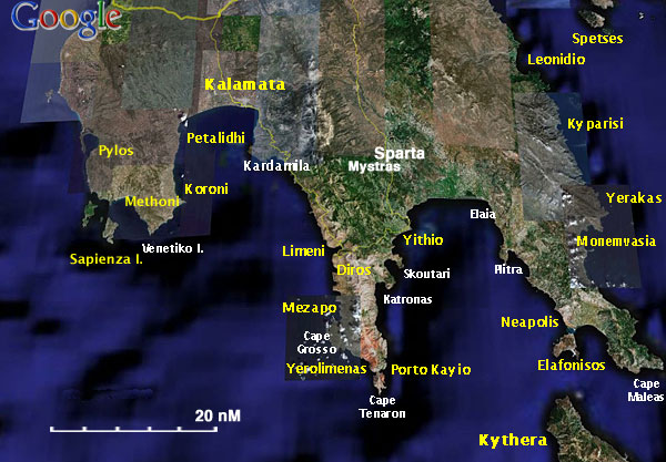

The coast of southern Peloponnese is not usually visited by cruising yachts unless they are in transit either moving east to the Aegean or west on their way back. Yet, it is a beautiful coast with many interesting anchorages.
The coast is dominated by the three peninsulas: Messinia dominated by Mount Taygetos, Mani ending into the capes Cavo Grosso and Tainaron, and finally the easternmost Cape Maleas.
Messinia was occupied by theVenetians who built two famous castles: Methoni and Koroni while within its gulf there is the city and harbor of Kalamata.
Mani has a history of being a nest of pirates and during the 400 years of Ottoman occupation was never really subjugated. It played a pivotal role during the Greek War of Independence in 1821. On the west side of the peninsula there is one of the largest caves in Greece the Cave of Dyros.
Inland of the Gulf of Laconia between Mani Mani and Cape Maleas is the city of Sparta and the nearby ghost Byzantine town of Mystras.
Charts
- BA
- 189 Nisos Sapiénza to Nisos Paxoi
- 682 Gulf of Kalamata
- 1030 South-west entrance channels to the Aegean sea
- 1685 Nisís Venetico to Nísos Spétsai including the channels between Akra Malléas and Kríti Yerakas
- Imray-Tetra
- G15 Southern Peloponnisos
- NIMA
- 54301 Kalamai and Approaches
- 54303 Lakonikos Kolpos
- Greek
- 22 Ionio Sea - Southern Part Zakynthos I. to C. Tainaro
- 43 Kriti I. - Wastern Part Cape Tainaro to Milos I.
Radio Nets
- Coast Guard - VHF channel 12
- Olympia Radio - VHF channels 27, 83, 84, or 86
Also see World Cruiser's Nets.
Weather
The winds here during the May - October period tend to be from the NE seldom exceeding force 4. During the November -April period they are from the SE often at gale force. But, because of the high mountains, there can be ferocious gusts especially near Capes Tainaron and Maleas.
There is a popular Greek proverb among sailors: "Από τον Κάβο Μαλιά δέκα μιλια μακρυά, κι’ από τον Κάβο Γκροσσο δέκα κι’ άλλα τόσο" ("Stay ten miles off Cape Malea, and from Cape Grosso ten and then ten more").
Another problem here is that the weather, because of moving depressions between Maleas and Crete, can deteriorate very quickly especially during the spring and fall months. During the summer months there can be thunderstorms and squalls near the shore.
Approaches in general are straightforward. Details are given for each port.
Check-in facilities (for Customs and Immigration)
Other than Pylos to the west, the only port of entry in this region is Kalamata.
Ports, Anchorages, and Islands
Ports
Methoni
| Methoni
| |
 Chart of Methoni - Click for larger view |
Methoni (Μεθώνη) is the site of a large Venetian castle and has a large natural harbor surrounded by the castle on one side and large sandy beaches on the other. The bay is only exposed to the SE winds. It is a spectacular site. It is believed that Cervantes was imprisoned by the Ottomans in the castle. The town is some distance from the castle and it is spread out.
Anchor to the N of of the old quay in 2-5 m depths. The bottom sand and mud, good holding.
Danger: Stay clear of the neighborhood of the old quay and its many submerged rocks.
Last Visited & Details Checked (and updated here)
Date of member's visit to this Port/Stop & this page's details validated:
- June 2001 --Istioploos

 Travels with S/Y Thetis
- April 2014 --LifePart2


Kalamata (Port of Entry)
| Kalamata
| |
 he Marina of Kalamata - Click for larger view |
Kalamata (Καλαμάτα) is the capital of the Messinia province. It is bustling modern city. It is a commercial harbor and it is always very busy. In the last few years a new modern marina started operations. The marina provides all the usual conveniences and has a reputation of being very well ran.
If you do visit the marina, make sure you dock west of the entrance; the afternoon breeze creates a bit of a swell in the east part --Deltasig
Last Visited & Details Checked (and updated here)
Date of member's visit to this Port/Stop & this page's details validated:
- June 2001 --Istioploos Travels with S/Y Thetis
- July 2013 --Deltasig
Yithio
| Yithio
| |
 Chart of Yithio - Click for larger view |
Yíthio (Γύθιο) or Gythio is a very pleasant harbor and the main city of the Mani region. It was the harbor of Ancient Sparta.
Yíthio is a good place to leave your yacht in order to visit Sparta and Mystras.
The harbor of Yíthio provides good protection from the NW prevailing winds. If those winds are strong there are also strong gusts here. Go bow or stern-to the mole, with strong NW winds, try the W quay. The bottom is mud and gives good holding.
Last Visited & Details Checked (and updated here)
Date of member's visit to this Port/Stop & this page's details validated:
Marinas & Yacht Clubs
Anchorages
Koroni
| Koroni
| |
 Sketch of Koroni - Click for larger view |
Koroni (Κορώνη) is an attractive town with an imposing Venetian castle. The shelter here from the prevailing NW-W winds is fairly good.
It is best to anchor off in 2-5 m depths in the bay W of the castle. The bottom is mostly mud and weed, it provides good holding. There is a small quay but the bottom there is fouled by old moorings and it is best to avoid it.
Warning: Near the shore there are large boulders where an anchor may be fouled. Watch out for them.
You can also anchor E of the breakwater in 4-5m.
Last Visited & Details Checked (and updated here)
Date of member's visit to this Port/Stop & this page's details validated:
- June 1995 --Istioploos Travels with S/Y Thetis
- August 2014 --Smoothtraveller


Petalidhi
| Petalidhi
| |
 Chart of Petalidhi - Click for larger view |
Petalidhi (Πεταλίδι) is a few miles SW of Kalamata. It is a quiet and pleasant anchorage in an attractive provincial town. Anchor off in 2-4 m on a sandy bottom which provides good holding.
Last Visited & Details Checked (and updated here)
Date of member's visit to this Port/Stop & this page's details validated:
- June 1995 --Istioploos Travels with S/Y Thetis
Limeni
| Limeni
| |
 Chart of Limeni - Click for larger view |
Limeni (Λιμένι) is large deep cove half way down the W side of the Mani Peninsula. It is very attractive, physically, and it is reputed to provide a good shelter. Anchor in 10-12 m, the bottom is sand and weed with some rocks
The whole cove gets very uncomfortable with the constant swell of the Messinian gulf especially in the afternoon and all night. One is better off taking a bit of shelter behind the makeshift rock jetty at Karavostasi. Make sure you avoid huge underwater rocks at the and of the dock and your anchor is set well because in the early hours of the morning it may blow strong N-NE through the valleys/canyons. I overnighted there so that I could visit the Diros Caves early in the morning before the afternoon W-SW breeze (at times F6) makes anchoring in Diros bay impossible. --Deltasig
There is a small museum in Limeni housed in the Mavromichalis Mansion.
Last Visited & Details Checked (and updated here)
Date of member's visit to this Port/Stop & this page's details validated:
- June 2001--Istioploos Travels with S/Y Thetis
- July 2013 --Deltasig
Diros
| Diros
| |
 Chart of Diros - Click for larger view |
Diros or Dyros (Δυρός) is just a few miles N of Mezapo. It is not a secure anchorage but in reasonable weather it is a "must stop" so that you can visit the famous Cave of Diros and the important neolithic site.
Anchor in front and to the E of the cave entrance (NE of the cove) in 8-10 m. The holding is reasonable.
Anchoring 50m right in front of the beach where you can see the steps leading to the entrance (5-6m depth) the holding is good; also, is close enough to row the dingy to the beach. Make sure you visit early in the day (caves open at 0830) and leave by early afternoon before the breeze builds up. --Deltasig
Last Visited & Details Checked (and updated here)
Date of member's visit to this Port/Stop & this page's details validated:
- June 2001 --Istioploos Travels with S/Y Thetis
- July 2013 --Deltasig

Mezapo
| Mezapo
| |
 Chart of Mezapo - Click for larger view |
Mezapo (Μέζαπο) is a large bay about a mile N of Cavo Grosso. It provides some reasonable shelter but there can be strong gusts, especially during the night.
Mezapo is the the largest anchorage of the famed Mani region of the Peloponnesos. Mani, before roads were built, was one of the most remote regions in Greece. During the Ottoman occupation, it was never subdued and kept a semi-autonomous existence. One of its main sources of wealth was piracy, the boats hiding in its many coves and pouncing at unsuspecting ships, heading for the Kythera channel.
Warning: The bottom here is uneven.
Last Visited & Details Checked (and updated here)
Date of member's visit to this Port/Stop & this page's details validated:
- June 2001 --Istioploos Travels with S/Y Thetis

Yerolimenas
| Yerolimenas
| |
 Chart of Yerolimenas - Click for larger view |
Yerolimenas or Gerolimenas (Γερολιμένας) is an inlet to the SW of Cape Tainaron and just NE of Cavo Grosso. It has a small quay used by fishing boats. The inlet is exposed to the prevailing W winds and is not very secure.
It is believed that a large Cave in Yerolimenas was the entrance to Hades, the Ancient Greek underworld.
Last Visited & Details Checked (and updated here)
Date of member's visit to this Port/Stop & this page's details validated:
- June 2001 --Istioploos Travels with S/Y Thetis

Porto Kayo
| Porto Kayo
| |
 Chart of Porto Kayo - Click for larger view |
Porto Kayo (Πόρτο Κάγιο) is an attractive anchorage just SE of Cape Tainaron. It offers fairly good shelter from the prevailing W-SW winds and from the NE winds. The little village used to be very appealing but lately has been "developed" with ugly buildings to the point that a Greek travel guide calls it "Porto Halio" (Port Shame).
With W-SW wind anchor on the S of the cove but be aware that the holding in the hard sand is not always good. With N winds, you want to be in N side but the bottom slope is very steep and you have to go very close to the shore. The bottom here is sand and weed, better holding.
Warning: There are many large rocks near the N side. Make sure you do not drift to them. During the night there can be strong gusts.
Last Visited & Details Checked (and updated here)
Date of member's visit to this Port/Stop & this page's details validated:
- June 2001 --Istioploos Travels with S/Y Thetis

Offshore Islands
Sapienza
| Sapienza
| |
 The Sapientza Lighthouse |
The island of Sapienza (Σαπιέντζα) is uninhabited save for one of the last remaining light-keepers in Greece. At the top of the island is the 1885 lighthouse, 100 m tall. It well worth a stop.
Unfortunately its lovely little cove of Port Longos has been despoiled by a fish-farm. Anchor in 5-6 m depths clear of the fish-farm. The bottom is sand, good holding. The cove is well protected from the prevailing winds but there is some swell with E winds.
The lighthouse is about a 15 minute walk along a trail.
Last Visited & Details Checked (and updated here)
Date of member's visit to this Port/Stop & this page's details validated:
- June 1995 --Istioploos Travels with S/Y Thetis

Yacht Repairs and Services
Marine Stores
- In the Kalamata Marina
Repairs
- In the Kalamata Marina
Fuel, Water, & Electricity
- Fuel
- In Methoni there is gas station at the end of the town, more than 500 m from the quay
- In Yithio a mini tanker usually delivers fuel, ask at the Limenarchio (Coast Guard)
- Water
- In Methoni there is a faucet root of the old quay
- In Yithio on the quay
- Electricity
- N/A (Not Available)
Things to do ashore
Tourism
In Methoni
A visit and a long walks along the ramparts of the castle is must.
In Sapienza
Visit the lighthouse, 15 walk from the anchorage.
Diros Cave
 The Cave of Diros |
From the Cove of Diros you must, of course visit the cave and the neolithic site. Make sure you arrive early in the morning and beat the crowd disgorged by the buses arriving in the late morning. The ticket booth is some walk uphill. Get tickets and wait your turn in from of the cave entrance. It more than worth it.
In Porto Kayo
 Mani Tower |
Take a long walk up the steep hill to see some good examples of the characteristic towers of Mani.
In Yithio
 Kranea Lighthouse |
In the town of Yithio you can visit archaeological excavation, the Museum, the castle, and the Kranea Lighthouse.
Sparta & Mystras
 The Pantanassa Monastery in Mystras Click for larger view |
From Yithio you can take a taxi to Sparta and Mystras (Μυστράς) (65 km).
In Sparta you can visit the Archaeological Museum and the Olive-Oil Museum.
Mystras is one of the most interesting sites in Greece. It is late Byzantine ghost town. You can wander along its buildings and then visit its Museum. It is an experience that you will never forget.
Grocery & Supply Stores
- Many stores in Kalamata
- A mini-market in Porto Kayo
- A supermarket in Yithio
Eateries
- Many tavernas in Kalamata
- There is a good restaurant in Porto Kayo
- There are several restaurants in Yithio
Internet/WiFi
Available?
Laundry
- In the Kalamata Marina
Motorbike & Car Rentals
Transportation
Flights to Athens from the airport in [[#Kalamata|Kalamata].
Routes/Passages To/From
Cruiser's Friends
Contact details of "Cruiser's Friends" that can be contacted for local information or assistance.
Forum Discussions
List links to discussion threads on partnering forums. (see link for requirements)
External Links
References & Publications
See Greece.
Personal Notes
Personal experiences?
Last Visited & Details Checked (and updated here)
See individual ports, anchorages, and islands in this page.
| This is a usable page of the cruising guide. However, please contribute if you can to help it grow further. Click on Comments to add your personal notes on this page or to discuss its contents. Alternatively, if you feel confident to edit the page, click on the edit tab at the top and enter your changes directly. |
| |
|---|
|
Names: Istioploos, Lighthouse |
| Cruising Wiki Navigation
|
|---|
| | HOMEPAGE | Wiki Contents | Mediterranean | Greece | South Peloponnese | |