Stari Grad
From CruisersWiki
m (bot: Weather) |
Istioploos (Talk | contribs) (Template) |
||
| (37 intermediate revisions not shown) | |||
| Line 1: | Line 1: | ||
| - | {{IsPartOf|Mediterranean|Adriatic Sea|Croatia|Hvar}} | + | {{IsPartOf|Mediterranean|Adriatic Sea|Croatia|Central Dalmatia|Hvar}} |
{{TOC block}} | {{TOC block}} | ||
| - | {{Infobox |43 | + | |
| - | | zoom= | + | {{Infobox |
| + | | lat=43.18382|lon=16.59738 | ||
| + | | name= Stari Grad | ||
| + | | zoom= 14 | ||
| + | | chartlet=y | ||
| + | | portofentry=y | ||
| image= StariGradScene.JPG | | image= StariGradScene.JPG | ||
| - | | imagetext= Stari Grad | + | | imagetext= Stari Grad |
| + | | summary= The town and harbour of [[Stari Grad]] (which means Old town) lie at the head of a four-mile long gulf carved into the NW coast of [[Hvar]] Island in [[Croatia]]. The oldest town in Croatia, the settlement is thought to have been founded by Greeks under the name of Faros in 385 BC. The town was the capital of the island until [[Hvar (town)|Hvar Town]] assumed that role in 1278. The setting is picturesque, with numerous narrow alleys and squares overlooked by fine old stone houses, of which one, that of the famed 16th-century Croatian poet, Petar Hektorovic, is now the town’s leading tourist attraction. | ||
| + | |||
| + | The harbour offers very good berthing options for visiting yachts, with around 75 berths distributed between its S quay and a row of mooring buoys off its shallow N quay. The shelter is excellent in all conditions except strong W and NW winds, which create a dangerous surge in the harbour. The harbour can also be subject to a phenomenon called 'plima' in Croatian, a ''seiche'' which causes rapid fall and rise of water levels by as much as 1.0 metre. This is most likely in very strong S winds and with low barometric pressures. Fortunately, this is a relatively rare occurrence (although the last such event was as recent as November 2012). | ||
| + | | notes= | ||
| + | | news= | ||
}} | }} | ||
| - | + | ||
| - | + | ==Charts== | |
| - | + | ''See [[Central Dalmatia#Charts|Central Dalmatia]]''. | |
| - | + | ||
| - | + | ||
==Weather== | ==Weather== | ||
| - | + | ''See [[Croatia#Weather|Croatia]]''. | |
| - | + | ==Passages== | |
| + | ''See [[Croatia#Passages|Croatia]]''. | ||
| - | + | ==Communication== | |
| + | {{contact | ||
| + | | type= officials | ||
| + | | name= Lučka kapetanija ispostava Stari Grad | ||
| + | | address= 21460 Stari Grad, p/p 15, Šetnica Don Šime Ljubića 1 | ||
| + | | VHF= | ||
| + | | phone= {{phone|385|21|765 060}} | ||
| + | | fax= | ||
| + | | email= | ||
| + | | web= http://www.lucka-uprava-sdz.hr/o-nama/popis-luka-pod-nadleznoscu-lusdz/luka/1231 | ||
| + | | hours= | ||
| + | | text= also http://www.mppi.hr/default.aspx?id=7594 | ||
| + | }} | ||
| + | {{contact | ||
| + | | type= officials | ||
| + | | name= Port reception | ||
| + | | address= Don Šime Ljubića 8 21460 Stari Grad | ||
| + | | VHF= | ||
| + | | phone= {{phone|385|21|65 432}} | ||
| + | | fax= | ||
| + | | email= [email protected] | ||
| + | | web= http://www.stari-grad.eu/en/nautical-info | ||
| + | | hours= | ||
| + | | text= | ||
| + | }} | ||
| - | == | + | ==Navigation== |
| - | + | There are no dangers in the immediate approach to [[Stari Grad]]. There is a green buoy at the entrance to the harbour marking a rocky reef. Depths in the entrance are 13.0 metres, on the town quay between 4.0 and 5.0 metres. Depths on the mooring buoys are 3.0 - 4.0 metres. | |
| - | + | ||
| - | + | ||
| - | + | ||
| - | + | ||
| - | + | ||
| - | + | ||
| - | == | + | ==Entrance== |
| - | + | [[Stari Grad]] is a summer port of entry only. At other times of the year, [[Split]] and [[Korčula]] are the nearest year-round ports of entry. | |
| - | + | ||
| - | + | ==Berthing== | |
| + | Both S and N town quays are operated as a marina with 120 wet berths and 30 dry berths. | ||
| - | == | + | {{hold vertical}} |
| - | + | {{poi | |
| + | | type=harbour | ||
| + | | name=S quay | ||
| + | | lat=43.18435|lon=16.59272 |zoom=17 | ||
| + | | url= | ||
| + | | image= StariGradQuay.JPG | ||
| + | | imagetext= Yachts on Stari Grad town quay | ||
| + | | text=The town quay on the S side of the inlet (past the short jetty where hotel boats berth) has been developed for visiting yachts and, with the recent extension of the new quay, now has around 60 mooring lines in depths ranging from 2.0 metres at the far E end to 5.0 metres at the W end near the jetty. There are water and electricity points all along the quay. | ||
| - | + | Shelter here is good in all but strong W or NW winds. | |
| - | + | ||
| - | + | There is a short jetty at the W end of the town quay, where it is possible for a couple of yachts to lie alongside temporarily (or out of season) in depths of 4.0 - 5.0 metres. During the season this jetty is heavily used by hotel and tripper boats. There is a water and an electricity point nearby on the quay. | |
| - | + | }} | |
| - | + | ||
| - | + | ||
| - | + | ||
| - | + | {{Image center| StariGradOldQuay.jpg| The old quay could accommodate 30 yachts|350px}} | |
| - | + | ||
| - | + | ||
| - | + | ||
| - | + | ||
| - | + | ||
| - | + | ||
| - | + | ||
| - | + | ||
| - | + | ||
| - | + | {{poi | |
| + | | type= harbour | ||
| + | | name=N quay | ||
| + | | lat=43.18516|lon=16.59304 |zoom=17 | ||
| + | | url= | ||
| + | | image= StariGradNewQuay.JPG | ||
| + | | imagetext= The new quay adds a further 30 berths | ||
| + | | text=Two sections of the N quay are also available for visiting yachts after the harbour has been refurbished in 2016. Water and electricity are at the points along the quay. | ||
| + | }} | ||
| + | |||
| + | {{poi | ||
| + | | type= harbour | ||
| + | | name=Hotel Helios jetty | ||
| + | | lat=43.18655|lon=16.58419 |zoom=16 | ||
| + | | url=http://www.heliosfaros.hr | ||
| + | | text= | ||
| + | A couple of yachts may moor alongside to the external (S) side of the jetty. Another couple of yachts may also get rafted at each of them. A fee is collected by the hotel (250 kunas as of 2018). | ||
| + | }} | ||
| + | {{hold vertical}} | ||
| + | {{poi | ||
| + | | type= harbour | ||
| + | | name=Ferry jetty | ||
| + | | lat=43.18119|lon=16.57722|zoom=16 | ||
| + | | url= | ||
| + | | image= StariGradFerry.JPG | ||
| + | | imagetext= A yacht can lie temporarily alongside at the E end of the ferry quay | ||
| + | | text=It is possible for short periods to tie up alongside at the E end of the ferry quay half a mile SW of the harbour entrance. This position is the only lowered section of the quay and it has the legend 'Taxi' painted on it in blue lettering, so it is wise not to linger too long. Depths here are around 3.0 metres, but shoal to less than 2.0 metres at the inner end. A hundred metres S of the quay, across the main road, is a large Tommy hypermarket and shopping complex big enough to stock up for a month’s cruising. | ||
| + | }} | ||
===Marinas & Yacht Clubs=== | ===Marinas & Yacht Clubs=== | ||
None. | None. | ||
| - | + | ==Anchorages== | |
| - | + | {{poi | |
| + | | type=buoy | ||
| + | | name=Mooring buoys | ||
| + | | lat=43.18512|lon=16.58973 |zoom=16 | ||
| + | | url= | ||
| + | | text=A row of 16 mooring buoys has been laid parallel to the N side of the harbour, some 50 metres off the shore (depths at the shore are currently too shallow for yachts). Visiting yachts can pick up one of these in depths of 3.0 - 4.0 metres. Charges here are HRK 21 per metre. Shelter here is good in all but strong W or NW winds. | ||
| + | }} | ||
| - | + | There are a number of good anchorages in the approach to Stari Grad. ''See [[Hvar#Anchorages|Hva]] Island for details''. | |
| - | + | ||
| - | == | + | ==Amenities== |
| - | + | {{tlist | |
| - | + | |header|Facilities | |
| - | + | ||
| - | + | ||
| - | + | ||
| - | ==== | + | |Water| {{mark | type= water |name= [[#S quay|S quay]] ||text= a point nearby on the quay}} |
| - | + | {{mark | type= water |name= [[#N quay|N quay]] ||text=at points along the quay}} | |
| + | |Electricity|{{mark | type= electricity |name= [[#S quay|S quay]] ||text= a point nearby on the quay}} | ||
| + | {{mark | type= electricity |name= [[#N quay|N quay]] ||text=at points along the quay}} | ||
| + | |Toilets| N/A (Not Available) | ||
| + | |Showers| N/A | ||
| + | |Laundry|In the town N of the harbour | ||
| + | |Garbage| Near the harbour | ||
| - | + | |header|Supplies | |
| - | + | ||
| - | + | ||
| - | + | ||
| - | + | ||
| - | + | ||
| - | + | ||
| - | ==== | + | |Fuel| {{mark |
| - | + | | type = fuel | |
| + | | lat=43.16625|lon=16.44494 | ||
| + | | name= INA | ||
| + | | url= https://www.ina.hr/trazilica-benzinskih-postaja/9763?bid=341 | ||
| + | | text = Fuel berth in a small inlet on E side of bay 500 metres S of harbour (0600 - 2200).<br/> Depths of only 1.8 metres alongside | ||
| + | }} | ||
| + | |Bottled gas| None | ||
| + | |Chandlers| None | ||
| - | + | |header|Services | |
| - | + | ||
| - | ==== | + | |Repairs| {{mark | type= service |name= |text= Basic emergency repairs only}} |
| - | In the town | + | |Internet| WiFi in several cafés along the waterfront |
| + | |Mobile connectivity| {{Green|Is there mobile telephone signal such as G4, G3, GPRS on the island? How strong is the signal? Are there any blind spots?}} | ||
| + | |Vehicle rentals| {{mark | type= car |name= In the town |text= Rental outlets}} | ||
| + | |Health| | ||
| + | }} | ||
| - | ==== | + | ==Provisioning== |
| - | + | {{mark | |
| + | | type=provisions | ||
| + | | name=Tommy | ||
| + | | lat=43.18513|lon=16.59937 | ||
| + | | url= | ||
| + | | text=large supermarket at head of inlet | ||
| + | }} | ||
| - | ==== | + | {{mark |
| - | + | | type=provisions | |
| + | | name=Studenac | ||
| + | | lat=43.18319|lon=16.60145 | ||
| + | | url= | ||
| + | | text=larger supermarket 200 metres inland | ||
| + | }} | ||
| - | === | + | {{mark |
| + | | type=provisions | ||
| + | | name=Tommy hypermarket | ||
| + | | lat=43.17975|lon=16.57625 | ||
| + | | url= | ||
| + | | text=and retail complex half a mile W of yacht quay. This is also a good place for kitchen and tableware, adults and children's clothes, footwear and even some electronics and computer items (upstairs) | ||
| + | }} | ||
| + | |||
| + | {{mark| type=provisions| name=In the Town | text=Several provisions shops, butchers, and bakers. Fruit and vegetable market behind tourist information office. Fish market.}} | ||
| + | |||
| + | ==Eating out== | ||
| + | * In the Town | ||
| + | : {{mark |name= | type= eatingout |text=Numerous restaurants and café/bars ashore.}} | ||
| + | |||
| + | ==Transportation== | ||
* Daily ferries to [[Split]]. | * Daily ferries to [[Split]]. | ||
* Seasonal ferries to [[Dubrovnik]]. | * Seasonal ferries to [[Dubrovnik]]. | ||
* Seasonal ferries to [[Ancona]], [[Pescara]] and [[Giulianova]] in Italy. | * Seasonal ferries to [[Ancona]], [[Pescara]] and [[Giulianova]] in Italy. | ||
| - | * Local buses to [[Hvar | + | * [http://stari-grad.hr/index.php?show=11433 Local buses] to [[Hvar (town)]] and other island destinations. |
| - | == | + | ==Tourism== |
| - | + | The old town of [[Stari Grad]] is a maze of narrow alleys and tiny squares, rigged with the stone houses typical of the Dalmatian islands. Among its most prized exhibits is the fortified house of the famous 16th-century Croatian poet, Petar Hektorovic, with a central courtyard containing a fish pond and beautiful gardens. | |
| - | + | Another highlight of a visit to Stari Grad is the 15th century Dominican monastery, fortified with a tower following a Turkish raid in 1571, which contains a museum with a painting of ''The Interment of Christ'' attributed to Tintoretto plus the oldest inscriptions unearthed in Croatia (in Greek) and a church with several fine altars. | |
| - | + | ||
| - | + | ||
| - | + | {{hgallery| | |
| - | + | {{himage|StariGradMansion.JPG| The 16th century fortress-house of Petar Hektorovic, it's garden with a pond, is now a museum}} | |
| - | + | {{himage|StariGradMonastery.JPG| The 15th century Dominican monastery}} | |
| - | + | {{himage|StariGradTown.jpg| Stari Grad is full of old stone houses}} | |
| + | }} | ||
| - | == | + | ==Links== |
* {{wikipedia|Stari_Grad,_Croatia}} | * {{wikipedia|Stari_Grad,_Croatia}} | ||
| - | * [http://www.stari-grad | + | * [http://www.stari-grad.eu/en/ Stari Grad Tourism website] |
| - | + | ||
* | * | ||
| - | ''Also see [[Croatia# | + | ''Also see [[Croatia#Links|Croatia]]''. |
| - | ==References | + | ==References== |
| - | ''See [[Croatia#References | + | ''See [[Croatia#References|Croatia]]''. |
| - | {{Comments | + | {{Comments}} |
| + | * | ||
| + | * | ||
{{Verified by}} | {{Verified by}} | ||
| - | |||
* September 2014 --[[User:Atheneoflymington|Athene of Lymington]] | * September 2014 --[[User:Atheneoflymington|Athene of Lymington]] | ||
* | * | ||
| - | |||
{{Page useable}} | {{Page useable}} | ||
| - | |||
{{Contributors|[[User:Lighthouse|Lighthouse]], [[User:Atheneoflymington|Athene of Lymington]]}} | {{Contributors|[[User:Lighthouse|Lighthouse]], [[User:Atheneoflymington|Athene of Lymington]]}} | ||
[[Category:Ports - Croatia]] [[Category:Anchorages - Croatia]] | [[Category:Ports - Croatia]] [[Category:Anchorages - Croatia]] | ||
Latest revision as of 22:12, 18 April 2019
| Stari Grad Port of Entry
| |
| | |
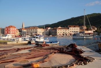
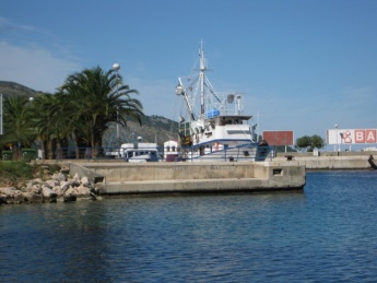
The town and harbour of Stari Grad (which means Old town) lie at the head of a four-mile long gulf carved into the NW coast of Hvar Island in Croatia. The oldest town in Croatia, the settlement is thought to have been founded by Greeks under the name of Faros in 385 BC. The town was the capital of the island until Hvar Town assumed that role in 1278. The setting is picturesque, with numerous narrow alleys and squares overlooked by fine old stone houses, of which one, that of the famed 16th-century Croatian poet, Petar Hektorovic, is now the town’s leading tourist attraction.
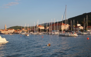
The harbour offers very good berthing options for visiting yachts, with around 75 berths distributed between its S quay and a row of mooring buoys off its shallow N quay. The shelter is excellent in all conditions except strong W and NW winds, which create a dangerous surge in the harbour. The harbour can also be subject to a phenomenon called 'plima' in Croatian, a seiche which causes rapid fall and rise of water levels by as much as 1.0 metre. This is most likely in very strong S winds and with low barometric pressures. Fortunately, this is a relatively rare occurrence (although the last such event was as recent as November 2012).
Charts
See Central Dalmatia.
Weather
See Croatia.
Passages
See Croatia.
Communication
Lučka kapetanija ispostava Stari Grad
- Phone: +385 (21) 765 060
- Web: http://www.lucka-uprava-sdz.hr/o-nama/popis-luka-pod-nadleznoscu-lusdz/luka/1231
- Address: 21460 Stari Grad, p/p 15, Šetnica Don Šime Ljubića 1
- also http://www.mppi.hr/default.aspx?id=7594
Port reception
- Phone: +385 (21) 65 432
- Email: [email protected]
- Web: http://www.stari-grad.eu/en/nautical-info
- Address: Don Šime Ljubića 8 21460 Stari Grad
There are no dangers in the immediate approach to Stari Grad. There is a green buoy at the entrance to the harbour marking a rocky reef. Depths in the entrance are 13.0 metres, on the town quay between 4.0 and 5.0 metres. Depths on the mooring buoys are 3.0 - 4.0 metres.
Entrance
Stari Grad is a summer port of entry only. At other times of the year, Split and Korčula are the nearest year-round ports of entry.
Berthing
Both S and N town quays are operated as a marina with 120 wet berths and 30 dry berths.
S quay
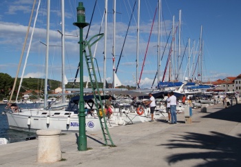
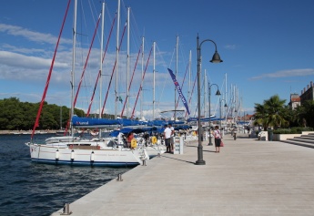
The town quay on the S side of the inlet (past the short jetty where hotel boats berth) has been developed for visiting yachts and, with the recent extension of the new quay, now has around 60 mooring lines in depths ranging from 2.0 metres at the far E end to 5.0 metres at the W end near the jetty. There are water and electricity points all along the quay.
Shelter here is good in all but strong W or NW winds.
There is a short jetty at the W end of the town quay, where it is possible for a couple of yachts to lie alongside temporarily (or out of season) in depths of 4.0 - 5.0 metres. During the season this jetty is heavily used by hotel and tripper boats. There is a water and an electricity point nearby on the quay.N quay
Hotel Helios jetty
Ferry jetty
Marinas & Yacht Clubs
None.
Anchorages
Mooring buoys
There are a number of good anchorages in the approach to Stari Grad. See Hva Island for details.
Amenities
| Facilities | |
|---|---|
| Water |
|
| Electricity |
|
| Toilets | N/A (Not Available) |
| Showers | N/A |
| Laundry | In the town N of the harbour |
| Garbage | Near the harbour |
| Supplies | |
| Fuel | Depths of only 1.8 metres alongside |
| Bottled gas | None |
| Chandlers | None |
| Services | |
| Repairs | |
| Internet | WiFi in several cafés along the waterfront |
| Mobile connectivity | Is there mobile telephone signal such as G4, G3, GPRS on the island? How strong is the signal? Are there any blind spots? |
| Vehicle rentals | |
| Health | |
Provisioning
![]() Tommy [[Stari Grad#Tommy|Tommy]] 43°11.108'N, 016°35.962'E large supermarket at head of inlet
Tommy [[Stari Grad#Tommy|Tommy]] 43°11.108'N, 016°35.962'E large supermarket at head of inlet
![]() Studenac [[Stari Grad#Studenac|Studenac]] 43°10.991'N, 016°36.087'E larger supermarket 200 metres inland
Studenac [[Stari Grad#Studenac|Studenac]] 43°10.991'N, 016°36.087'E larger supermarket 200 metres inland
![]() Tommy hypermarket [[Stari Grad#Tommy hypermarket|Tommy hypermarket]] 43°10.785'N, 016°34.575'E and retail complex half a mile W of yacht quay. This is also a good place for kitchen and tableware, adults and children's clothes, footwear and even some electronics and computer items (upstairs)
Tommy hypermarket [[Stari Grad#Tommy hypermarket|Tommy hypermarket]] 43°10.785'N, 016°34.575'E and retail complex half a mile W of yacht quay. This is also a good place for kitchen and tableware, adults and children's clothes, footwear and even some electronics and computer items (upstairs)
![]() In the Town [[Stari Grad#In the Town|In the Town]] Several provisions shops, butchers, and bakers. Fruit and vegetable market behind tourist information office. Fish market.
In the Town [[Stari Grad#In the Town|In the Town]] Several provisions shops, butchers, and bakers. Fruit and vegetable market behind tourist information office. Fish market.
Eating out
- In the Town
-
 [[Stari Grad# | ]] Numerous restaurants and café/bars ashore.
Transportation
- Daily ferries to Split.
- Seasonal ferries to Dubrovnik.
- Seasonal ferries to Ancona, Pescara and Giulianova in Italy.
- Local buses to Hvar (town) and other island destinations.
Tourism
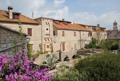
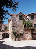
The old town of Stari Grad is a maze of narrow alleys and tiny squares, rigged with the stone houses typical of the Dalmatian islands. Among its most prized exhibits is the fortified house of the famous 16th-century Croatian poet, Petar Hektorovic, with a central courtyard containing a fish pond and beautiful gardens.
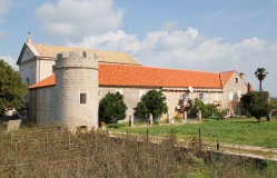
Another highlight of a visit to Stari Grad is the 15th century Dominican monastery, fortified with a tower following a Turkish raid in 1571, which contains a museum with a painting of The Interment of Christ attributed to Tintoretto plus the oldest inscriptions unearthed in Croatia (in Greek) and a church with several fine altars.
Links
- Stari Grad at the Wikipedia
- Stari Grad Tourism website
Also see Croatia.
References
See Croatia.
Comments
We welcome users' contributions to the Wiki. Please click on Comments to view other users' comments, add your own personal experiences or recommend any changes to this page following your visit.
Verified by
Date of member's last visit to Stari Grad and this page's details validated:
- September 2014 --Athene of Lymington
| This is a usable page of the cruising guide. However, please contribute if you can to help it grow further. Click on Comments to add your personal notes on this page or to discuss its contents. Alternatively, if you feel confident to edit the page, click on the edit tab at the top and enter your changes directly. |
| |
|---|
|
Names: Lighthouse, Athene of Lymington |
