Suriname
From CruisersWiki
(→Charts) |
(→Special Navigation Notes) |
||
| Line 45: | Line 45: | ||
===Special Navigation Notes=== | ===Special Navigation Notes=== | ||
| - | + | Start your approach at the outer marker at LW. The trip to Domburg is, calculated from the outer marker, approximately 35 miles. You can do it in one tide if you start at LW. At that time the water level seems quite low, even in the channel, but you will never see less than 1.5 m below the keel (assuming a draft of 2 m). The channel is well buoyed and buoys are regularly moved if necessary. Even at night the approach is a piece of cake because they are all lit and... the lights are working! Keep red to starboard (IALA-B). | |
| + | Notify M.A.S. (Maritime Authority Suriname) on VHF12. | ||
===Local Radio Nets=== | ===Local Radio Nets=== | ||
Revision as of 16:43, 7 July 2010
Suriname Cruising Guide
An online cruising guide for yachts sailing to Suriname.
Background
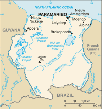
Suriname, formerly the colony of Netherlands Guiana or Dutch Guiana, is a country in Northern South America. It has a North Atlantic Ocean coastline in the north and is surrounded by French Guiana to the east, Brazil to the south and Guyana to the west. It is the smallest independent country on South American continent. The relatively small population lives mostly along the coast.
Climate & Weather
Tropical, but moderated by trade winds. At 6 N you would expect a hot and humid climate, but the eastern tradewinds keep Suriname relatively cool. Temperatures on average: 31°C. Wind (on land, in general) E 5-10 kts
Suriname has two rainy seasons and two dry seasons, but in the dry seasons you can still expect some rain. Very welcome for most yachties! Short rainy season: December and January
Short dry season: February until mid April
Long rainy season: mid April until mid-July
Long dry season: mid July until November
Charts
BA 517 Trinidad to Cayenne
NK 2017 Suriname: Cayenne tot Demerara
NK 2014 Suriname: Corantijn tot Surinamerivier
BA 99 Entrances to Rivers in Guyana and Suriname
Start your approach at the outer marker at LW. The trip to Domburg is, calculated from the outer marker, approximately 35 miles. You can do it in one tide if you start at LW. At that time the water level seems quite low, even in the channel, but you will never see less than 1.5 m below the keel (assuming a draft of 2 m). The channel is well buoyed and buoys are regularly moved if necessary. Even at night the approach is a piece of cake because they are all lit and... the lights are working! Keep red to starboard (IALA-B). Notify M.A.S. (Maritime Authority Suriname) on VHF12.
Local Radio Nets
Also see World Cruiser's Nets
Submit details of Cruiser's Nets and VHF operating/calling channels here.
Arrival/Departure procedures
Submit any details about advance notification of arrival, etc.
Immigration
Submit details about immigration procedures here.
Customs
Details?
Health
Submit any health warnings/information
Security
Details
Ports & Popular Stops
- Domburg
- Paramaribo (Port of entry)
Offshore Islands
Details?
Cruiser's Friends
Submit details/contacts of cruiser's "friends" that can be contacted in advance or on arrival - who can offer information and assistance to our cruising "family".
References & Publications
Books, Guides. etc.
Links to CruiserLog Forum discussions
Links to discussions on the CruiserLog Forum
External Links
Submit useful website links for the region
Personal Notes
Personal experiences?
| |
|---|
| | HOMEPAGE | Wiki Contents | North Atlantic | South America | Suriname | |
.

