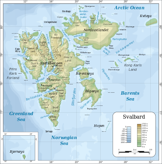
Svalbard
From CruisersWiki
An online cruising guide for sailing along the coast of Norway.
| Svalbard
| |
| Capital | Oslo |
|---|---|
| Language | Norwegian (Bokmål and Nynorsk). English is widely spoken. |
| Currency | Kroner (NOK) |
| Time zone | UTC+1 (DST observed) |
| Calling code | ? |
| Map does not show Jan Mayen, Bear Island or Svalbard | |
Svalbard island group Cruising Guide
Svalbard (formerly known by its Dutch name Spitsbergen) is a Norwegian archipelago in the Arctic Ocean. Situated north of mainland Europe, it is about midway between continental Norway and the North Pole.
Add here any background, cruising, and historical comments.
Cruising the region
Add any cruising recommendations. If not applicable delete this section.
- Source
- Chart Number - Chart Name
- Chart Number - Chart Name
- Source
- Chart Number - Chart Name
Weather and Winds
Give weather conditions in the region or refer to another page (a country?) that covers these conditions.
Sources for weather information:
Currents & Tides
Any navigation notes here. If this section does not apply remove it.
Regional Radio Nets
- VHF coastal stations are issuing weatherforcast (in norwegian) and traffic lists (in english for foreign vessels) on their WORKING Channels (most can receive channel 16 and or MDSS. But you have to call them on a working channel preferably (see coastal radio frequency plan). They will give you the latest forecast in English on request.
Also see World Cruiser's Nets.
Islands in the Group
- Spitsbergen
- Nordaustlandet
- Edgeøya
![]() = Port of entry,
= Port of entry, ![]() = Marina,
= Marina, ![]() = Harbor,
= Harbor, ![]() = Anchorage,
= Anchorage, ![]() = Needs data.
= Needs data.
Things to do Ashore
See individual islands.
Routes/Passages To/From
List popular passages/routes, timing, etc.
- Tromsoe - Longyearbyen (Svalbard) 550 nm
- Tromsoe - Bear island (Bjornoya - VHF ch 66) between Tromsoe and Svalbard 290 nm
Cruiser's Friends
Contact details of "Cruiser's Friends" that can be contacted for local information or assistance.
Forum Discussions
List links to discussion threads on partnering forums. (see link for requirements)
External Links
References & Publications
Books, Guides, etc
- The Norwegian Pilot Guide – Sailing Directions, 8 volumes for Norwegian coast, Svalbard and Jan Mayen (PDF-files downloadable available free of charge) [1]
- Norway Oslo to North Cape and Svalbard, Judy Lomax, RCC Pilotage Foundation, [2], ISBN 978 184623 284 8, Last Update 2010
- Phyllis Nickel and John Harries Norwegian Cruising Guide 2010 Attainable Adventure Cruising Ltd, ISBN 978-9769520431. eBook (downloadable) & printed.
- Jon Amtrup Sail to Svalbard, ISBN 978-82-92284-58-2, eBook (downloadable) & printed, Last Update 2011
Personal Notes
Personal experiences?
Last Visited & Details Checked (and updated here)
Date of member's visit to this Island Group & this page's details validated:
If you provide a lot of info and this page is almost complete, change {{Page outline}} to {{Page useable}}.
| This page has an outline in place but needs completing. Please contribute if you can to help it grow further. Click on Comments to suggest further content or alternatively, if you feel confident to edit this page, click on the edit tab at the top and enter your changes directly. |
| |
|---|
|
Names: User:La0fd |
Add all the pages that are "parent" to this one.
| Cruising Wiki Navigation
|
|---|
| | HOMEPAGE | Wiki Contents | Place Page Links Here | Place Page Links Here | This Island Group | |
[[Category:Islands - Country1?]] [[Category:Islands - Country2?]]

