Termoli
From CruisersWiki
Istioploos (Talk | contribs) (Amenities/Facilities) |
Istioploos (Talk | contribs) (Update) |
||
| Line 1: | Line 1: | ||
{{IsPartOf|Mediterranean|Adriatic Sea|Italy|Adriatic Coast of Italy}} | {{IsPartOf|Mediterranean|Adriatic Sea|Italy|Adriatic Coast of Italy}} | ||
{{TOC block}} | {{TOC block}} | ||
| + | |||
{{Infobox | {{Infobox | ||
| lat=42.00317 | lon=15.005 | | lat=42.00317 | lon=15.005 | ||
| + | | name= Termoli | ||
| zoom= 15 | | zoom= 15 | ||
| chartlet= y | | chartlet= y | ||
| image= TermoliHarbour.jpg | | image= TermoliHarbour.jpg | ||
| imagetext= Termoli harbour from E, prior to the construction of the marina | | imagetext= Termoli harbour from E, prior to the construction of the marina | ||
| + | | summary= The town of Termoli lies on the Adriatic coast of [[Italy]] 10 miles WNW of the Promontorio del Gargano, the ‘spur’ projecting from the ‘boot’ of the peninsula. It is a popular resort with a historic walled old town and a distinctively-shaped Norman castle. Since September 2009, with the completion of a new, small marina, [[Marina di San Pietro]], immediately S of the commercial port, Termoli now provides berthing for over 300 yachts of up to 30 metres. The town’s good beaches and proximity to the Gargano National Park attract several thousand, mostly Italian, tourists to the town and its surrounding area each year. Termoli is also an important port of embarkation for visitors to the [[Tremiti Islands]] 25 miles ENE of the harbour. | ||
| + | | notes= | ||
| + | | news= | ||
}} | }} | ||
| - | |||
==Charts== | ==Charts== | ||
| Line 18: | Line 22: | ||
==Weather== | ==Weather== | ||
| - | During the summer months the prevailing winds in the Adriatic are light to moderate coastal | + | During the summer months, the prevailing winds in the Adriatic are light to moderate coastal sea breezes. In spring and autumn, northerly winds are more frequent and can quickly rise to near gale force, especially in the northern Adriatic, where the much-feared “bora” is caused by high pressure over the mountains to the NE coupled with low pressure over southern Italy. Fortunately, the fiercest “bora” is normally to be expected in the winter months. Thunderstorms are occasionally experienced in spring and especially autumn and can be accompanied by violent winds of gale force and above. Luckily they are rarely long-lasting. In the southern Adriatic, the “Scirocco”, a S/SE wind blowing up from North Africa which can last for several days, is more common. Unlike the “bora”, which can arrive without warning, a “scirocco” tends to build in strength over 24-48 hours, sometimes reaching gale force (especially in winter). |
Sources for weather information: | Sources for weather information: | ||
| - | * There is a continuous ( | + | * There is a continuous (computerized voice) weather forecast on VHF 68 - first in Italian and then followed with an English translation |
* The same forecast is given in Italian and English on VHF coastal stations following a notification on channel 16 | * The same forecast is given in Italian and English on VHF coastal stations following a notification on channel 16 | ||
* Navtex weather forecasts covering the Adriatic are broadcast from stations at Roma, Trieste, Kerkyra (Greece) and Split (Croatia) | * Navtex weather forecasts covering the Adriatic are broadcast from stations at Roma, Trieste, Kerkyra (Greece) and Split (Croatia) | ||
| Line 33: | Line 37: | ||
==Communication== | ==Communication== | ||
| + | {{Green|Add here VHF channel for the coastguard, harbor masters. etc.}} | ||
* | * | ||
* | * | ||
| Line 39: | Line 44: | ||
==Navigation== | ==Navigation== | ||
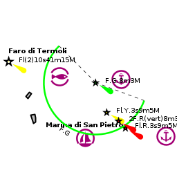
| - | The walled town standing proud on an easily-defended peninsula is conspicuous from distance. | + | The walled town standing proud on an easily-defended peninsula is conspicuous from distance. The harbour is entered from SE, holding a course about 50 metres inside the outer breakwater, the Diga Foranea, to clear the shoal water extending over 100 metres E from the new marina breakwater to port. Depths in the entrance are 5.0 - 6.0 metres. Entry can be difficult in strong SE winds. If berthing in the commercial harbour, enter through the narrow entrance between the south mole and the breakwater. If berthing in the new marina, turn hard to port once through the entrance for the larger berths on the south mole. Call on VHF channel 13 to the Marinucci Yacht Club for berthing assistance once inside the breakwater. |
| - | If berthing in the commercial harbour, enter through the narrow entrance between the south mole and the breakwater. If berthing in the new marina, turn hard to port once through the entrance for the larger berths on the south mole. Call on VHF channel 13 to the Marinucci Yacht Club for berthing assistance once inside the breakwater. | + | |
==Berthing== | ==Berthing== | ||
| - | All berths on the south mole and in the commercial harbour are operated by the '''Marinucci Yachting Club''' | + | All berths on the south mole and in the commercial harbour are operated by the '''Marinucci Yachting Club'''. There are around 40 berths in the commercial harbor for yachts of up to 8 metres on pontoons and quays.The berths here are usually filled by local yachts, but there may be space outside busy periods. The newer marina on the south mole, [[Marina di San Pietro]], provides a total of 250 berths for yachts of up to 30 metres in depths of 3.5 - 4.5 meters. |
| + | : {{email|[email protected]}}; Tel: {{phone|39|0875|702238}}; VHF channel 13 | ||
===Marinas & Yacht Clubs=== | ===Marinas & Yacht Clubs=== | ||
| Line 58: | Line 63: | ||
|Water| Water on the pontoons and in the [[Marina di San Pietro|marina]] | |Water| Water on the pontoons and in the [[Marina di San Pietro|marina]] | ||
|Electricity| Electricity on the pontoons and in the [[Marina di San Pietro|marina]] | |Electricity| Electricity on the pontoons and in the [[Marina di San Pietro|marina]] | ||
| - | |Toilets| | + | |Toilets| In the [[Marina di San Pietro|marina]] |
| - | |Showers| | + | |Showers| In the [[Marina di San Pietro|marina]] |
|Laundry| None | |Laundry| None | ||
|Garbage| Bins in [[Marina di San Pietro]] and on the Molo Sud | |Garbage| Bins in [[Marina di San Pietro]] and on the Molo Sud | ||
| Line 66: | Line 71: | ||
|Fuel| Fuel station on the Molo Sud quay (24 hr) | |Fuel| Fuel station on the Molo Sud quay (24 hr) | ||
|Bottled gas| {{MagentaText|?}} | |Bottled gas| {{MagentaText|?}} | ||
| - | |Chandlers| | + | |Chandlers| None |
|header|Services | |header|Services | ||
| - | |Repairs| Slipway. | + | |Repairs| Slipway. Fixed crane (20 T). Mobile crane (250 T). Some hard standing. Engine and electrical repairs. Wood, fiberglass and steel hull repairs. Divers |
| - | |Internet| | + | |Internet| WiFi in [[Marina di San Pietro]] |
|Mobile connectivity| {{MagentaText|?}} | |Mobile connectivity| {{MagentaText|?}} | ||
|Vehicle rentals| Rental outlets in the town | |Vehicle rentals| Rental outlets in the town | ||
| Line 80: | Line 85: | ||
==Eating out== | ==Eating out== | ||
Numerous restaurants in the old town. | Numerous restaurants in the old town. | ||
| - | |||
==Transportation== | ==Transportation== | ||
| Line 88: | Line 92: | ||
==Tourism== | ==Tourism== | ||
====Places to Visit==== | ====Places to Visit==== | ||
| - | The walled mediaeval town on the peninsula has been well restored and is worth a couple of hours’ exploration. | + | The walled mediaeval town on the peninsula has been well restored and is worth a couple of hours’ exploration. Inside the walls are a 12th century Norman cathedral and a 13th century Swabian castle which dominates the site. |
| - | + | {{hgallery| | |
| - | + | {{himage|TermoliTown.jpg|Termoli old town}} | |
| - | + | {{himage|TermoliCathedral.jpg|Termoli cathedral}} | |
| - | + | {{himage|TermoliCastle.jpg|Termoli 13th century castle}} | |
| - | + | }} | |
==Friends== | ==Friends== | ||
| Line 106: | Line 110: | ||
==Links== | ==Links== | ||
* {{wikipedia}} | * {{wikipedia}} | ||
| + | * {{Wikivoyage}} | ||
* | * | ||
| Line 124: | Line 129: | ||
{{Contributors|[[User:Atheneoflymington|Athene of Lymington]], [[User:Barbjgladney|Barbjgladney]] }} | {{Contributors|[[User:Atheneoflymington|Athene of Lymington]], [[User:Barbjgladney|Barbjgladney]] }} | ||
| - | [[Category:Ports - Italy]] | + | [[Category:Ports - Italy]] [[Category:Marinas - Italy]] |
Revision as of 18:27, 2 June 2018
| Termoli
| |
| |
 Termoli harbour from E, prior to the construction of the marina |
The town of Termoli lies on the Adriatic coast of Italy 10 miles WNW of the Promontorio del Gargano, the ‘spur’ projecting from the ‘boot’ of the peninsula. It is a popular resort with a historic walled old town and a distinctively-shaped Norman castle. Since September 2009, with the completion of a new, small marina, Marina di San Pietro, immediately S of the commercial port, Termoli now provides berthing for over 300 yachts of up to 30 metres. The town’s good beaches and proximity to the Gargano National Park attract several thousand, mostly Italian, tourists to the town and its surrounding area each year. Termoli is also an important port of embarkation for visitors to the Tremiti Islands 25 miles ENE of the harbour.
Charts
- British Admiralty
- 200
- Italian
- 922
- 33
Weather
During the summer months, the prevailing winds in the Adriatic are light to moderate coastal sea breezes. In spring and autumn, northerly winds are more frequent and can quickly rise to near gale force, especially in the northern Adriatic, where the much-feared “bora” is caused by high pressure over the mountains to the NE coupled with low pressure over southern Italy. Fortunately, the fiercest “bora” is normally to be expected in the winter months. Thunderstorms are occasionally experienced in spring and especially autumn and can be accompanied by violent winds of gale force and above. Luckily they are rarely long-lasting. In the southern Adriatic, the “Scirocco”, a S/SE wind blowing up from North Africa which can last for several days, is more common. Unlike the “bora”, which can arrive without warning, a “scirocco” tends to build in strength over 24-48 hours, sometimes reaching gale force (especially in winter).
Sources for weather information:
- There is a continuous (computerized voice) weather forecast on VHF 68 - first in Italian and then followed with an English translation
- The same forecast is given in Italian and English on VHF coastal stations following a notification on channel 16
- Navtex weather forecasts covering the Adriatic are broadcast from stations at Roma, Trieste, Kerkyra (Greece) and Split (Croatia)
Passages
See Adriatic.
Islands
Communication
Add here VHF channel for the coastguard, harbor masters. etc.
Also see World Cruiser's Nets.
The walled town standing proud on an easily-defended peninsula is conspicuous from distance. The harbour is entered from SE, holding a course about 50 metres inside the outer breakwater, the Diga Foranea, to clear the shoal water extending over 100 metres E from the new marina breakwater to port. Depths in the entrance are 5.0 - 6.0 metres. Entry can be difficult in strong SE winds. If berthing in the commercial harbour, enter through the narrow entrance between the south mole and the breakwater. If berthing in the new marina, turn hard to port once through the entrance for the larger berths on the south mole. Call on VHF channel 13 to the Marinucci Yacht Club for berthing assistance once inside the breakwater.
Berthing
All berths on the south mole and in the commercial harbour are operated by the Marinucci Yachting Club. There are around 40 berths in the commercial harbor for yachts of up to 8 metres on pontoons and quays.The berths here are usually filled by local yachts, but there may be space outside busy periods. The newer marina on the south mole, Marina di San Pietro, provides a total of 250 berths for yachts of up to 30 metres in depths of 3.5 - 4.5 meters.
- [email protected]; Tel: +39 (0875) 702238; VHF channel 13
Marinas & Yacht Clubs
Anchorages
No anchoring in the harbour.
Amenities
| Facilities | |
|---|---|
| Water | Water on the pontoons and in the marina |
| Electricity | Electricity on the pontoons and in the marina |
| Toilets | In the marina |
| Showers | In the marina |
| Laundry | None |
| Garbage | Bins in Marina di San Pietro and on the Molo Sud |
| Supplies | |
| Fuel | Fuel station on the Molo Sud quay (24 hr) |
| Bottled gas | ? |
| Chandlers | None |
| Services | |
| Repairs | Slipway. Fixed crane (20 T). Mobile crane (250 T). Some hard standing. Engine and electrical repairs. Wood, fiberglass and steel hull repairs. Divers |
| Internet | WiFi in Marina di San Pietro |
| Mobile connectivity | ? |
| Vehicle rentals | Rental outlets in the town |
Provisioning
Several provisions shops in the town.
Eating out
Numerous restaurants in the old town.
Transportation
- Buses to most local destinations from the town.
- Railway station with connections to most destinations.
Tourism
Places to Visit
The walled mediaeval town on the peninsula has been well restored and is worth a couple of hours’ exploration. Inside the walls are a 12th century Norman cathedral and a 13th century Swabian castle which dominates the site.


Friends
Contact details of "Cruiser's Friends" that can be contacted for local information or assistance.
Forums
List links to discussion threads on partnering forums. (see link for requirements)
Links
References & Publications
See Italy.
Comments
We welcome users' contributions to the Wiki. Please click on Comments to view other users' comments, add your own personal experiences or recommend any changes to this page following your visit.
Verified by
Date of member's last visit to Termoli and this page's details validated:
- May 2017 --Barbjgladney
| This is a usable page of the cruising guide. However, please contribute if you can to help it grow further. Click on Comments to add your personal notes on this page or to discuss its contents. Alternatively, if you feel confident to edit the page, click on the edit tab at the top and enter your changes directly. |
| |
|---|
|
Names: Athene of Lymington, Barbjgladney |