Trizonia
From CruisersWiki
m (→Last Visited & Details Checked (and updated here)) |
m (Sunken yacht removed from marina basin) |
||
| (22 intermediate revisions not shown) | |||
| Line 1: | Line 1: | ||
| - | + | {{IsPartOf|Mediterranean|Aegean Sea|Greece}} | |
| - | {| | + | {{TOC block}} |
| - | | | + | |
| - | | | + | {{Infobox | lat=38.36558 | lon=22.07183 |
| - | + | | zoom= 13 | |
| - | + | | chartlet= y | |
| - | + | | image= Greece_Trizonia_h.jpg | |
| - | + | | imagetext= Chart of Trizonia | |
| - | + | }} | |
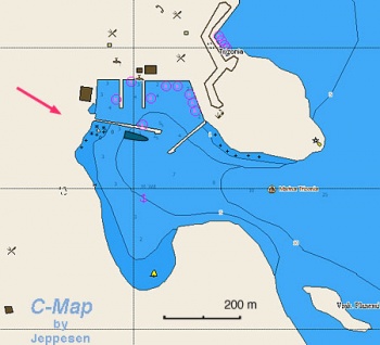
| - | | | + | Trizónia (Τριζόνια) is a small island on the NW side of the Gulf of Corinth, 12 miles E of [[Korinthiakos_Kolpos#Nafpaktos|Navpaktos]] and 15 miles W of [[Galaxidhi]]. It lies directly opposite the mainland town of Glifadha. There is only one small hamlet on the island, yet there are several restaurants on the waterfront serving the local specialty: crayfish. In a sheltered bay on the E side of the island, protected from E by the islet of Ay. Ioannis, construction began in the 90's on a marina. While the basic infrastructure was completed, the marina was never finished, but what was left was a perfectly usable and very well sheltered harbour and anchorage where visiting yachts can moor for free. Trizonia is thus a popular port of call for yachts cruising along the N coast of the Gulf between the [[Patraikos_Kolpos|Gulf of Patras]] and the [[Corinth Canal]]. There is little to do on the island, but it is an excellent place to ‘chill out’ and recharge the batteries (even if that is not possible with the yacht batteries). |
| - | | | + | |
| - | + | ||
| - | + | ||
| - | | | + | |
| - | | | + | |
| - | + | ||
==Charts== | ==Charts== | ||
| Line 26: | Line 20: | ||
: 232 Korinthiakos Kolpos | : 232 Korinthiakos Kolpos | ||
| - | == | + | ==Weather== |
| + | ''See [[Korinthiakos_Kolpos#Weather|Korinthiakos Kolpos]]''. | ||
| + | |||
| + | ==Passages== | ||
| + | * [[Circumnavigating the Peloponnese]] | ||
| + | * [[Aegean_to_West_Mediterranean_Passages#Northern_Route_Via_Strait_of_Messina_and_N_of_Sicily|Aegean to West/East Mediterranean, Northern Route]] | ||
| + | |||
| + | ==Islands== | ||
| + | * Ay. Ioannis | ||
| + | |||
| + | ==Communication== | ||
* Coast Guard - VHF channel 12, tel. +30 27410 28 888 | * Coast Guard - VHF channel 12, tel. +30 27410 28 888 | ||
* Olympia Radio - VHF channels 02, 64, & 85 | * Olympia Radio - VHF channels 02, 64, & 85 | ||
''Also see [[World MM Nets|World Cruiser's Nets]]'' | ''Also see [[World MM Nets|World Cruiser's Nets]]'' | ||
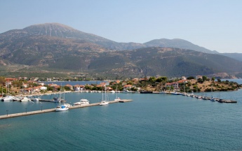
| + | {{Image right|TrizoniaMarina.jpg |Trizonia ‘marina’ from SW }} | ||
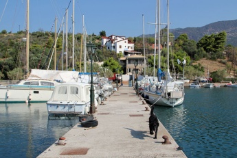
| + | {{Image right|TrizoniaJetty.jpg |Jetty at Trizonia }} | ||
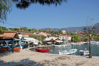
| + | {{Image right|TrizoniaTavernas.jpg |Trizonia waterfront tavernas }} | ||
| + | {{Image right|TrizoniaWaterfront.jpg |Trizonia waterfront }} | ||
| + | {{Image right|TrizoniaSubrmarine.jpg | 'Darling, did you remember to close the seacocks?' }} | ||
| - | + | ==Navigation== | |
| - | + | ||
| - | + | ||
| - | + | ||
| - | + | ||
| - | + | ||
| - | == | + | |
| - | + | ||
| - | + | ||
| - | + | ||
The approach to Trizonia is either from SE, between it and the smaller islet of Ay, Ioannis, or from NW between it and the mainland. There are no hazards in the approach from SE, but note that a reef extends in parts for 200-300 metres from the N and NE shores of the island and a very wide approach is necessary to avoid it. Once into the bay on the E side of the island, the ‘marina’ is entered from SW between the two long protective breakwaters. Depths in the entrance to the bay are 9.0 – 10.0 metres and in the marina entrance 5.0 – 6.0 metres. Shelter in the bay is very good from all directions, although E winds send in a chop. Shelter in the marina is excellent. | The approach to Trizonia is either from SE, between it and the smaller islet of Ay, Ioannis, or from NW between it and the mainland. There are no hazards in the approach from SE, but note that a reef extends in parts for 200-300 metres from the N and NE shores of the island and a very wide approach is necessary to avoid it. Once into the bay on the E side of the island, the ‘marina’ is entered from SW between the two long protective breakwaters. Depths in the entrance to the bay are 9.0 – 10.0 metres and in the marina entrance 5.0 – 6.0 metres. Shelter in the bay is very good from all directions, although E winds send in a chop. Shelter in the marina is excellent. | ||
| - | == | + | ==Entrance== |
The nearest port of entry is [[Patras]]. | The nearest port of entry is [[Patras]]. | ||
| - | ==Berthing | + | ==Berthing== |
====Ports==== | ====Ports==== | ||
The "marina" is the only place to moor on the island. While there is a small harbour on the NE side used by the small fishing boats, it does not offer good shelter and is relatively shallow. The marina consists of a long, outer E breakwater extending from the shore of the peninsula that shelters the marina from NE and a shorter, inner W breakwater extending from the opposite shore. Inside there are also two long concrete jetties extending due S from the northern shore. Yachts berth in one of five positions: | The "marina" is the only place to moor on the island. While there is a small harbour on the NE side used by the small fishing boats, it does not offer good shelter and is relatively shallow. The marina consists of a long, outer E breakwater extending from the shore of the peninsula that shelters the marina from NE and a shorter, inner W breakwater extending from the opposite shore. Inside there are also two long concrete jetties extending due S from the northern shore. Yachts berth in one of five positions: | ||
| Line 56: | Line 56: | ||
# Alternatively, anchor off in the bay. Depths are 5.0 - 6.0 metres and the holding is good in mud and weed. Make sure, however, that your anchor is well dug in before going ashore as yachts have dragged here. | # Alternatively, anchor off in the bay. Depths are 5.0 - 6.0 metres and the holding is good in mud and weed. Make sure, however, that your anchor is well dug in before going ashore as yachts have dragged here. | ||
| - | + | {{Note}} The yacht that has sunk at its moorings between the two jetties (see below right) was removed in 2018. | |
Many boats have wintered here. Despite the "marina" it is an attractive anchorage. | Many boats have wintered here. Despite the "marina" it is an attractive anchorage. | ||
| Line 63: | Line 63: | ||
The "marina" is unfinished for at least 15 years now. There are no services. | The "marina" is unfinished for at least 15 years now. There are no services. | ||
| - | + | ==Anchorages== | |
You can anchor off in the cove. It provides an excellent all around shelter. | You can anchor off in the cove. It provides an excellent all around shelter. | ||
| - | == | + | ==Amenities== |
| - | + | {{tlist | |
| - | + | |header|Facilities | |
| - | + | ||
| - | + | ||
| - | + | |Water| In the hamlet of [[#Trizonia|Trizonia]] | |
| - | + | |Electricity| N/A (Not Available) | |
| + | |Toilets| N/A | ||
| + | |Showers| N/A | ||
| + | |Laundry| N/A | ||
| + | |Garbage| There are bins around the "marina" | ||
| - | + | |header|Supplies | |
| - | + | |Fuel| N/A | |
| - | + | |Bottled gas| {{MagentaText|?}} | |
| - | + | |Chandlers| None | |
| - | + | ||
| - | + | ||
| - | + | ||
| - | + | |header|Services | |
| - | + | |Repairs| N/A | |
| - | + | |Internet| In ''Kalypso'' and ''Poseidon'' tavernas on the waterfront | |
| + | |Mobile connectivity| {{MagentaText|?}} | ||
| + | |Vehicle rentals| N/A | ||
| + | }} | ||
| - | == | + | ==Provisioning== |
Very basic groceries only. | Very basic groceries only. | ||
| - | == | + | ==Eating out== |
| - | + | Several tavernas and cafes around the waterfront NE of the "marina". | |
| - | + | ||
| - | + | ||
| - | + | ||
| - | + | ||
| - | + | ||
| - | + | ||
| - | + | ||
| - | + | ||
| - | + | ||
| - | + | ||
| - | + | ||
| - | + | ||
| - | + | ==Transportation== | |
There are daily ferries to Glifadha on the mainland. | There are daily ferries to Glifadha on the mainland. | ||
| - | == | + | ==Tourism== |
| - | + | The island is partly wooded and the walks from the waterfront round the N side and in the other direction round the E side of the island are both very pleasant. There is not a lot to do otherwise. | |
| - | + | ||
| - | == | + | ==Friends== |
Contact details of "Cruiser's Friends" that can be contacted for local information or assistance. | Contact details of "Cruiser's Friends" that can be contacted for local information or assistance. | ||
* | * | ||
| - | == | + | ==Forums== |
List links to discussion threads on [[Cruising Forums|partnering forums]]. (''see link for requirements'') | List links to discussion threads on [[Cruising Forums|partnering forums]]. (''see link for requirements'') | ||
* | * | ||
| - | == | + | ==Links== |
| + | * [http://en.wikipedia.org/wiki/Trizonia_island Trizonia] at Wikipedia | ||
* [http://www.angelfire.com/super2/greece/trizonia.html Trizonia] | * [http://www.angelfire.com/super2/greece/trizonia.html Trizonia] | ||
| - | ==References | + | ==References== |
''See [[Greece#References_&_Publications|Greece]]''. | ''See [[Greece#References_&_Publications|Greece]]''. | ||
| - | + | {{Comments}} | |
| - | + | ||
* | * | ||
| - | + | {{Verified by}} | |
| - | * October 2004 | + | * October 2004 {{Istioploos2}} |
* September 2011 --[[User:Atheneoflymington|Athene of Lymington]] 16:55, 19 September 2011 (BST) | * September 2011 --[[User:Atheneoflymington|Athene of Lymington]] 16:55, 19 September 2011 (BST) | ||
* May 2012 --[[User:Monterey|Monterey]] [[Image:Bermuda Icon.png]] | * May 2012 --[[User:Monterey|Monterey]] [[Image:Bermuda Icon.png]] | ||
* June 2013 --[[User:Vigdis|Vigdis]] [[File:Sailboat favicon.png]] [http://yachtvigdis.wordpress.com yachtvigdis blog] | * June 2013 --[[User:Vigdis|Vigdis]] [[File:Sailboat favicon.png]] [http://yachtvigdis.wordpress.com yachtvigdis blog] | ||
| + | * July 2019 --[[User:Meir|Bat-Yam]] | ||
| - | {{ | + | {{Page useable}} |
| - | + | ||
| - | |||
| - | |||
| - | |||
| - | |||
| - | |||
| - | |||
| - | |||
| - | |||
| - | + | {{Contributors|[[User:Istioploos|Istioploos]], [[User:Atheneoflymington|Athene of Lymington]]}} | |
| - | { | + | |
| - | + | ||
| - | + | ||
| - | + | ||
| - | + | ||
| - | + | ||
| - | [[Category:Islands | + | [[Category:Islands - Greece]] |
Latest revision as of 10:23, 22 July 2019
| Trizonia
| |
| | |
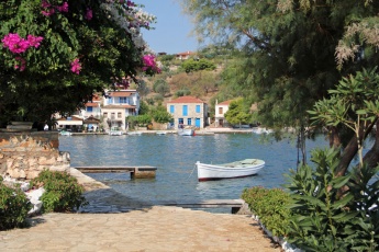
Trizónia (Τριζόνια) is a small island on the NW side of the Gulf of Corinth, 12 miles E of Navpaktos and 15 miles W of Galaxidhi. It lies directly opposite the mainland town of Glifadha. There is only one small hamlet on the island, yet there are several restaurants on the waterfront serving the local specialty: crayfish. In a sheltered bay on the E side of the island, protected from E by the islet of Ay. Ioannis, construction began in the 90's on a marina. While the basic infrastructure was completed, the marina was never finished, but what was left was a perfectly usable and very well sheltered harbour and anchorage where visiting yachts can moor for free. Trizonia is thus a popular port of call for yachts cruising along the N coast of the Gulf between the Gulf of Patras and the Corinth Canal. There is little to do on the island, but it is an excellent place to ‘chill out’ and recharge the batteries (even if that is not possible with the yacht batteries).
Charts
- BA
- 1600 Korinthiakós Kólpos
- Imray-Tetra
- G13 Gulfs of Patras and Corinth
- NIMA
- 54289 Korinthiakos Kolpos
- Greek
- 232 Korinthiakos Kolpos
Weather
See Korinthiakos Kolpos.
Passages
Islands
- Ay. Ioannis
Communication
- Coast Guard - VHF channel 12, tel. +30 27410 28 888
- Olympia Radio - VHF channels 02, 64, & 85
Also see World Cruiser's Nets
The approach to Trizonia is either from SE, between it and the smaller islet of Ay, Ioannis, or from NW between it and the mainland. There are no hazards in the approach from SE, but note that a reef extends in parts for 200-300 metres from the N and NE shores of the island and a very wide approach is necessary to avoid it. Once into the bay on the E side of the island, the ‘marina’ is entered from SW between the two long protective breakwaters. Depths in the entrance to the bay are 9.0 – 10.0 metres and in the marina entrance 5.0 – 6.0 metres. Shelter in the bay is very good from all directions, although E winds send in a chop. Shelter in the marina is excellent.
Entrance
The nearest port of entry is Patras.
Berthing
Ports
The "marina" is the only place to moor on the island. While there is a small harbour on the NE side used by the small fishing boats, it does not offer good shelter and is relatively shallow. The marina consists of a long, outer E breakwater extending from the shore of the peninsula that shelters the marina from NE and a shorter, inner W breakwater extending from the opposite shore. Inside there are also two long concrete jetties extending due S from the northern shore. Yachts berth in one of five positions:
- Alongside either of the two concrete jetties, wherever there is space. The inner ends are occupied by local boats on laid moorings. Do not attempt an anchor moor here as there are mooring chains along the jetty. The quay is quite rough here and liable to damage fenders if you are not careful. Mooring bollards are plentiful but there are no other facilities on the jetties. Depths are 3.0 – 4.0 metres.
- Alongside (or, during busy periods, stern/bows-to) the inside of either breakwater. The bollards are widely spaced here but there are also mooring rings set into the wall in places if you are doing an anchor moor. Depths here are also 3.0 – 4.0 metres and the holding is good in mud.
- Alongside the outside of the W breakwater. Depths here are only 2.5 – 3.0 metres, so this position is not suitable for deep draft yachts. Note that the area towards the root of the outside of this breakwater is dangerously shallow.
- Alongside (or, during busy periods, stern/bows-to) the outside of the E breakwater. Depths here are greater, at 4.0 – 5.0 metres, and bollards are plentiful. This position is, however, only suitable in settled weather and becomes very uncomfortable with anything E in the wind.
- Alternatively, anchor off in the bay. Depths are 5.0 - 6.0 metres and the holding is good in mud and weed. Make sure, however, that your anchor is well dug in before going ashore as yachts have dragged here.
Note: The yacht that has sunk at its moorings between the two jetties (see below right) was removed in 2018.
Many boats have wintered here. Despite the "marina" it is an attractive anchorage.
Marinas & Yacht Clubs
The "marina" is unfinished for at least 15 years now. There are no services.
Anchorages
You can anchor off in the cove. It provides an excellent all around shelter.
Amenities
| Facilities | |
|---|---|
| Water | In the hamlet of Trizonia |
| Electricity | N/A (Not Available) |
| Toilets | N/A |
| Showers | N/A |
| Laundry | N/A |
| Garbage | There are bins around the "marina" |
| Supplies | |
| Fuel | N/A |
| Bottled gas | ? |
| Chandlers | None |
| Services | |
| Repairs | N/A |
| Internet | In Kalypso and Poseidon tavernas on the waterfront |
| Mobile connectivity | ? |
| Vehicle rentals | N/A |
Provisioning
Very basic groceries only.
Eating out
Several tavernas and cafes around the waterfront NE of the "marina".
Transportation
There are daily ferries to Glifadha on the mainland.
Tourism
The island is partly wooded and the walks from the waterfront round the N side and in the other direction round the E side of the island are both very pleasant. There is not a lot to do otherwise.
Friends
Contact details of "Cruiser's Friends" that can be contacted for local information or assistance.
Forums
List links to discussion threads on partnering forums. (see link for requirements)
Links
References
See Greece.
Comments
We welcome users' contributions to the Wiki. Please click on Comments to view other users' comments, add your own personal experiences or recommend any changes to this page following your visit.
Verified by
Date of member's last visit to Trizonia and this page's details validated:
- October 2004 --Istioploos

 Travels with S/Y Thetis
- September 2011 --Athene of Lymington 16:55, 19 September 2011 (BST)
- May 2012 --Monterey

- June 2013 --Vigdis
 yachtvigdis blog
- July 2019 --Bat-Yam
| This is a usable page of the cruising guide. However, please contribute if you can to help it grow further. Click on Comments to add your personal notes on this page or to discuss its contents. Alternatively, if you feel confident to edit the page, click on the edit tab at the top and enter your changes directly. |
| |
|---|
|
Names: Istioploos, Athene of Lymington |
