Venice - Piave Vecchia
From CruisersWiki
Istioploos (Talk | contribs) m (→References & Publications: Cosmetic) |
m (Text replace - "#References & Publications|" to "#References|") |
||
| (4 intermediate revisions not shown) | |||
| Line 1: | Line 1: | ||
{{IsPartOf|Mediterranean|Italy|Venice to Trieste|Venice|Venetian Lagoon}} | {{IsPartOf|Mediterranean|Italy|Venice to Trieste|Venice|Venetian Lagoon}} | ||
{{TOC block}} | {{TOC block}} | ||
| - | {{Infobox |45 | + | |
| - | | zoom= | + | {{Infobox |
| + | | lat= 45.477| lon=12.584 | ||
| + | | name= Piave Vecchia | ||
| + | | portofentry= | ||
| + | | zoom= 10 | ||
| + | | chartlet = y | ||
| image= PiaveVecchiaMap.jpg | | image= PiaveVecchiaMap.jpg | ||
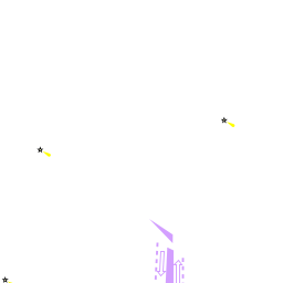
| imagetext= The location of Piave Vecchia on the lagoon of Venice | | imagetext= The location of Piave Vecchia on the lagoon of Venice | ||
| - | + | | summary= The canal port of '''Piave Vecchia''' (also sometimes referred to as Porto Cavallino) is situated at the mouth of the Sile river, which disgorges into the Adriatic eight miles NE of the Porto di Lido entrance to the [[Venetian Lagoon]] and half a mile E of the settlement of Cavallino. Although not strictly part of Venice, the marinas in the river here are conveniently situated for visiting the city and have good transport links. They are also generally easier to access in the right conditions than many of the marinas in the lagoon. There are four principal marina operations here where yachts of up to 30 metres can find a berth in depths of up to 6.0 metres. | |
| - | + | | notes= | |
| - | + | | news= | |
| - | The canal port of '''Piave Vecchia''' (also sometimes referred to as Porto Cavallino) is situated at the mouth of the Sile river, which disgorges into the Adriatic eight miles NE of the Porto di Lido entrance to the [[Venetian Lagoon]] and half a mile E of the settlement of Cavallino. | + | }} |
| - | + | ||
| - | + | ||
==Charts== | ==Charts== | ||
| Line 22: | Line 25: | ||
==Weather== | ==Weather== | ||
| - | During the summer months the prevailing winds in the Adriatic are light to moderate coastal | + | During the summer months, the prevailing winds in the Adriatic are light to moderate coastal sea breezes. In spring and autumn, northerly winds are more frequent and can quickly rise to near gale force, especially in the northern Adriatic, where the much-feared “bora” is caused by high pressure over the mountains to the NE coupled with low pressure over southern Italy. Fortunately, the fiercest “bora” is normally to be expected in the winter months. Thunderstorms are occasionally experienced in spring and especially autumn and can be accompanied by violent winds of gale force and above. Luckily they are rarely long-lasting. Fog is a further hazard often encountered in the lagoon of Venice, especially in the early and late season. |
Sources for weather information: | Sources for weather information: | ||
| - | * There is a continuous ( | + | * There is a continuous (computerized voice) weather forecast on VHF 68 - first in Italian and then followed with an English translation |
* The same forecast is given in Italian and English on VHF coastal stations following a notification on channel 16 | * The same forecast is given in Italian and English on VHF coastal stations following a notification on channel 16 | ||
* Navtex weather forecasts covering the Adriatic are broadcast from stations at Roma, Trieste, Kerkyra (Greece) and Split (Croatia) | * Navtex weather forecasts covering the Adriatic are broadcast from stations at Roma, Trieste, Kerkyra (Greece) and Split (Croatia) | ||
| - | |||
| - | |||
| - | |||
| - | |||
| - | |||
| - | |||
==Passages== | ==Passages== | ||
| - | + | ''See [[Aegean to West Mediterranean Passages]]''. | |
| - | + | ||
==Islands== | ==Islands== | ||
| Line 50: | Line 46: | ||
*San Michele | *San Michele | ||
*Isola le Vignole | *Isola le Vignole | ||
| + | |||
| + | ==Communication== | ||
| + | {{Green|Add here VHF channel for the coastguard, harbor masters. etc.}} | ||
| + | * | ||
| + | * | ||
| + | |||
| + | ''Also see [[World MM Nets|World Cruiser's Nets]]''. | ||
==Navigation== | ==Navigation== | ||
| - | Access to Piave Vecchia is via the mouth of the | + | {{Image right| PiaveVecchiaAerial.jpg| The entrance to Piave Vecchia from the E }} |
| + | Access to Piave Vecchia is via the mouth of the {{mark | lat= 45.47817 |lon=12.58451 |zoom=15| type= waypoint| name= Sile river}}, which is flanked by two moles extending into the Adriatic Sea among the miles of beaches lining this coast. The prominent Piave Vecchia lighthouse on the W side of the entrance is visible from some considerable distance. The entrance is narrow and a good lookout is needed for other vessels leaving the river, especially in poor visibility. The approach should be made on a course of around 335 degrees to keep in the deepest water. The better depths are on the W side, close to the lighthouse. The channel here is dredged to a depth of 3.5 metres. However, as with most of the harbours along this coast, entry is best during the last hour or so of the tide, which can add up to a metre to the depths in the entrance. An entry should not be attempted in strong onshore winds, when it is safer to seek a berth in the lagoon via the Porto Lido. The various marinas are situated on either side of the river from half a mile to one mile from the entrance. | ||
==Berthing== | ==Berthing== | ||
| - | Yachts visiting Piave Vecchia have four principal berthing options, from the large Porto Turistico | + | ===Marinas & Yacht Clubs=== |
| + | Yachts visiting '''Piave Vecchia''' have four principal berthing options, from the large [[Porto Turistico del Jesolo]] to the mini-harbour of [[Marina del Faro]]. In order from the river entrance, the options are: | ||
| - | [[Marina del Faro]] | + | {{poi | lat= 45.48405| lon=12.58436 |
| + | | type= marina | ||
| + | | name= [[Marina del Faro]] | ||
| + | | altname= | ||
| + | | url = | ||
| + | | zoom=16 | ||
| + | | portofentry= | ||
| + | | image= | ||
| + | | imagetext= | ||
| + | | text= Marina del Faro is a small basin on the W side of the river about half a mile from the entrance.It offers 100 berths for yachts up to 16 metres in maximum depths of 5.0 metres. | ||
| + | }} | ||
| - | + | {{poi | lat= 45.48555| lon= 12.58324 | |
| + | | type= marina | ||
| + | | name= [[Marina del Cavallino]] | ||
| + | | altname= | ||
| + | | url = | ||
| + | | zoom= 17 | ||
| + | | portofentry= | ||
| + | | image= | ||
| + | | imagetext= | ||
| + | | text= Marina del Cavallino lies on the W side of the river immediately N of [[Marina del Faro]]. It has 300 berths for yachts up to 30 metres in depths of 6.0 metres. | ||
| + | }} | ||
| - | [[Marina | + | {{poi | lat= {{Magenta|DD.ddd}} | lon= {{Magenta|DD.ddd}} |
| + | | type= marina | ||
| + | | name= [[Marina Nautica dal Vi]] | ||
| + | | altname= | ||
| + | | url = | ||
| + | | zoom= 16 | ||
| + | | portofentry= | ||
| + | | image= | ||
| + | | imagetext= | ||
| + | | text= Marina Nautica dal Vi is situated on the E side of the river 300 metres further upstream from Marina del Cavallino. It has 450 berths for yachts up to 16 metres in depths of 2.5 metres. | ||
| + | }} | ||
| - | + | {{poi | lat=45.48995 | lon=12.58409 | |
| + | | type= marina | ||
| + | | name= [[Porto Turistico del Jesolo]] | ||
| + | | altname= | ||
| + | | url = | ||
| + | | zoom= 16 | ||
| + | | portofentry= | ||
| + | | image= | ||
| + | | imagetext= | ||
| + | | text= Porto Turistico del Jesolo is the largest marina in the river, situated a futher 5-0 metres upriver from Nautica dal Vi on the E bank. Following a recent extension project, it has 638 berths for yachts up to 30 metres in depths of 4.5 metres. | ||
| + | }} | ||
| - | + | ==Anchorages== | |
| + | None. The river is unsuitable for anchoring. | ||
| - | + | ==Amenities== | |
| + | {{tlist | ||
| - | + | |header|Facilities | |
| - | + | |Water| In [[Marina del Faro]], [[Marina del Cavallino]], [[Marina Nautica dal Vi]], and [[Porto Turistico del Jesolo]] | |
| + | |Electricity| In [[Marina del Faro]], [[Marina del Cavallino]], [[Marina Nautica dal Vi]], and [[Porto Turistico del Jesolo]] | ||
| + | |Toilets| In [[Marina del Faro]], [[Marina del Cavallino]], [[Marina Nautica dal Vi]], and [[Porto Turistico del Jesolo]] | ||
| + | |Showers| In [[Marina del Faro]], [[Marina del Cavallino]], [[Marina Nautica dal Vi]], and [[Porto Turistico del Jesolo]] | ||
| + | |Laundry| In [[Marina del Faro]], and [[Porto Turistico del Jesolo]] | ||
| + | |Garbage| Bins at the [[#Marinas & Yacht Clubs|marinas]] | ||
| - | + | |header|Supplies | |
| - | + | |Fuel | | |
| + | * [[Marina del Cavallino]] - Station on the quay (0800-1200 & 1400-1800) | ||
| + | * [[Marina Nautica dal Vi]] - Fuel station upriver on the E bank | ||
| + | |Bottled gas| {{MagentaText|?}} | ||
| + | |Chandlers| In [[Marina del Cavallino]] | ||
| - | * [[Marina del Faro]] | + | |header|Services |
| - | * [[Marina del Cavallino]] | + | |Repairs| |
| - | * [[Marina Nautica dal Vi]] | + | * [[Marina del Faro]] - Slipway. Hardstanding. Fixed crane (15 T). Engine, electrical and electronic repairs. Wood and fiberglass hull repairs. Paintworks. Sail repairs |
| - | * [[Porto Turistico del Jesolo]] | + | * [[Marina del Cavallino]] - Slipway. Hardstanding. Travel lift (50 T). Fixed crane (15 T). Engine, electrical and electronic repairs. Wood and fiberglass hull repairs. Paintworks. Sail repairs Divers |
| - | + | * [[Marina Nautica dal Vi]] - Small yard. Some hard standing. Travel lift (50 T). Fixed crane (25 T). Engine and electrical repairs. Wood and fiberglass hull repairs. Paintworks. Divers | |
| - | + | * [[Porto Turistico del Jesolo]] - Provides shipyard work such as refitting, joinery, assistance with mechanical, engine-related, hydraulic, electric and electronic matters, upholstery, an on-site fuel dispenser, washing, interior disinfection, boat storage, a travel lift for up to 100 tonnes, masting and dismasting | |
| - | + | |Internet| WiFi in [[Marina del Faro]], and [[Porto Turistico del Jesolo]] | |
| - | + | |Mobile connectivity| {{MagentaText|?}} | |
| - | + | |Vehicle rentals| Rental outlets in Cavallino 2 km to the W | |
| - | + | }} | |
| - | + | ||
| - | + | ||
| - | + | ||
| - | + | ||
| - | + | ||
| - | + | ||
| - | + | ||
| - | + | ||
| - | + | ||
| - | + | ||
| - | + | ||
| - | + | ||
| - | == | + | ==Provisioning== |
Provisions shops within easy reach of W bank marinas, but little on E bank. | Provisions shops within easy reach of W bank marinas, but little on E bank. | ||
| - | ==== | + | ==Eating out== |
| - | Bars and restaurants within easy reach of W bank marinas, but little on E bank | + | * [[Marina del Faro]], [[Marina del Cavallino], and [[Porto Turistico del Jesolo]] - Bar and restaurant |
| + | * Bars and restaurants within easy reach of W bank marinas, but little on E bank | ||
| - | + | ==Transportation== | |
| - | + | ||
| - | + | ||
| - | + | ||
| - | + | ||
| - | + | ||
| - | + | ||
| - | + | ||
| - | + | ||
| - | + | ||
| - | + | ||
| - | + | ||
| - | + | ||
* Ferries from Piave Vecchia into [[Venice]] | * Ferries from Piave Vecchia into [[Venice]] | ||
* Marco Polo airport just N of Mestre has flights to most international destinations | * Marco Polo airport just N of Mestre has flights to most international destinations | ||
| Line 124: | Line 157: | ||
* Ferries from Venice to several destinations in Greek islands and Croatia | * Ferries from Venice to several destinations in Greek islands and Croatia | ||
* Vaporetti (water buses) serving Venice and outlying islands | * Vaporetti (water buses) serving Venice and outlying islands | ||
| + | |||
| + | ==Tourism== | ||
| + | ''See [[Venice#Tourism|Venice]]''. | ||
==Friends== | ==Friends== | ||
| Line 136: | Line 172: | ||
==Links== | ==Links== | ||
* {{wikipedia|Cavallino-Treporti}} | * {{wikipedia|Cavallino-Treporti}} | ||
| + | * {{Wikivoyage|Jesolo|Jesolo}} | ||
* [http://www.turismovenezia.it/eng/ Official tourism website] | * [http://www.turismovenezia.it/eng/ Official tourism website] | ||
| - | |||
| - | |||
* [http://www.veniceconnected.com/ Venice Connected] | * [http://www.veniceconnected.com/ Venice Connected] | ||
| - | ==References | + | ==References== |
| - | ''See [[Italy#References | + | ''See [[Italy#References|Italy]]''. |
| - | {{Comments | + | {{Comments}} |
* | * | ||
| Line 152: | Line 187: | ||
| - | {{Page | + | {{Page useable}} |
Latest revision as of 08:03, 21 August 2018
| Piave Vecchia
| |
| |
 The location of Piave Vecchia on the lagoon of Venice |
The canal port of Piave Vecchia (also sometimes referred to as Porto Cavallino) is situated at the mouth of the Sile river, which disgorges into the Adriatic eight miles NE of the Porto di Lido entrance to the Venetian Lagoon and half a mile E of the settlement of Cavallino. Although not strictly part of Venice, the marinas in the river here are conveniently situated for visiting the city and have good transport links. They are also generally easier to access in the right conditions than many of the marinas in the lagoon. There are four principal marina operations here where yachts of up to 30 metres can find a berth in depths of up to 6.0 metres.
Charts
- British Admiralty
- 204
- 1483
- Italian
- 924
- 38
- 222
Weather
During the summer months, the prevailing winds in the Adriatic are light to moderate coastal sea breezes. In spring and autumn, northerly winds are more frequent and can quickly rise to near gale force, especially in the northern Adriatic, where the much-feared “bora” is caused by high pressure over the mountains to the NE coupled with low pressure over southern Italy. Fortunately, the fiercest “bora” is normally to be expected in the winter months. Thunderstorms are occasionally experienced in spring and especially autumn and can be accompanied by violent winds of gale force and above. Luckily they are rarely long-lasting. Fog is a further hazard often encountered in the lagoon of Venice, especially in the early and late season.
Sources for weather information:
- There is a continuous (computerized voice) weather forecast on VHF 68 - first in Italian and then followed with an English translation
- The same forecast is given in Italian and English on VHF coastal stations following a notification on channel 16
- Navtex weather forecasts covering the Adriatic are broadcast from stations at Roma, Trieste, Kerkyra (Greece) and Split (Croatia)
Passages
See Aegean to West Mediterranean Passages.
Islands
There are no offshore islands but a total of 117 small islands in the lagoon, some inhabited but many of them little more than extensive mudbanks. The principal inhabited islands are as follows:
Communication
Add here VHF channel for the coastguard, harbor masters. etc.
Also see World Cruiser's Nets.

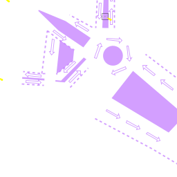
Access to Piave Vecchia is via the mouth of the ![]() Sile river [[Venice - Piave Vecchia#Sile river|Sile river]] 45°28.690'N, 012°35.071'E , which is flanked by two moles extending into the Adriatic Sea among the miles of beaches lining this coast. The prominent Piave Vecchia lighthouse on the W side of the entrance is visible from some considerable distance. The entrance is narrow and a good lookout is needed for other vessels leaving the river, especially in poor visibility. The approach should be made on a course of around 335 degrees to keep in the deepest water. The better depths are on the W side, close to the lighthouse. The channel here is dredged to a depth of 3.5 metres. However, as with most of the harbours along this coast, entry is best during the last hour or so of the tide, which can add up to a metre to the depths in the entrance. An entry should not be attempted in strong onshore winds, when it is safer to seek a berth in the lagoon via the Porto Lido. The various marinas are situated on either side of the river from half a mile to one mile from the entrance.
Sile river [[Venice - Piave Vecchia#Sile river|Sile river]] 45°28.690'N, 012°35.071'E , which is flanked by two moles extending into the Adriatic Sea among the miles of beaches lining this coast. The prominent Piave Vecchia lighthouse on the W side of the entrance is visible from some considerable distance. The entrance is narrow and a good lookout is needed for other vessels leaving the river, especially in poor visibility. The approach should be made on a course of around 335 degrees to keep in the deepest water. The better depths are on the W side, close to the lighthouse. The channel here is dredged to a depth of 3.5 metres. However, as with most of the harbours along this coast, entry is best during the last hour or so of the tide, which can add up to a metre to the depths in the entrance. An entry should not be attempted in strong onshore winds, when it is safer to seek a berth in the lagoon via the Porto Lido. The various marinas are situated on either side of the river from half a mile to one mile from the entrance.
Berthing
Marinas & Yacht Clubs
Yachts visiting Piave Vecchia have four principal berthing options, from the large Porto Turistico del Jesolo to the mini-harbour of Marina del Faro. In order from the river entrance, the options are:
Marina del Faro
Marina del Cavallino
Marina Nautica dal Vi
Porto Turistico del Jesolo
Anchorages
None. The river is unsuitable for anchoring.
Amenities
| Facilities | |
|---|---|
| Water | In Marina del Faro, Marina del Cavallino, Marina Nautica dal Vi, and Porto Turistico del Jesolo |
| Electricity | In Marina del Faro, Marina del Cavallino, Marina Nautica dal Vi, and Porto Turistico del Jesolo |
| Toilets | In Marina del Faro, Marina del Cavallino, Marina Nautica dal Vi, and Porto Turistico del Jesolo |
| Showers | In Marina del Faro, Marina del Cavallino, Marina Nautica dal Vi, and Porto Turistico del Jesolo |
| Laundry | In Marina del Faro, and Porto Turistico del Jesolo |
| Garbage | Bins at the marinas |
| Supplies | |
| Fuel |
|
| Bottled gas | ? |
| Chandlers | In Marina del Cavallino |
| Services | |
| Repairs |
|
| Internet | WiFi in Marina del Faro, and Porto Turistico del Jesolo |
| Mobile connectivity | ? |
| Vehicle rentals | Rental outlets in Cavallino 2 km to the W |
Provisioning
Provisions shops within easy reach of W bank marinas, but little on E bank.
Eating out
- Marina del Faro, [[Marina del Cavallino], and Porto Turistico del Jesolo - Bar and restaurant
- Bars and restaurants within easy reach of W bank marinas, but little on E bank
Transportation
- Ferries from Piave Vecchia into Venice
- Marco Polo airport just N of Mestre has flights to most international destinations
- Budget flights also from Treviso airport (30 km)
- Trains from Venice station to Rome, Milan, Florence and Padua and several European capitals
- Ferries from Venice to several destinations in Greek islands and Croatia
- Vaporetti (water buses) serving Venice and outlying islands
Tourism
See Venice.
Friends
Contact details of "Cruiser's Friends" that can be contacted for local information or assistance.
Forums
List links to discussion threads on partnering forums. (see link for requirements)
Links
- Venice - Piave Vecchia at the Wikipedia
- Jesolo at the Wikivoyage
- Official tourism website
- Venice Connected
References
See Italy.
Comments
We welcome users' contributions to the Wiki. Please click on Comments to view other users' comments, add your own personal experiences or recommend any changes to this page following your visit.
Verified by
Date of member's last visit to Venice - Piave Vecchia and this page's details validated:
- Data compiled from web research (please update if possible)--Athene of Lymington 19:25, 25 January 2011 (UTC)
| This is a usable page of the cruising guide. However, please contribute if you can to help it grow further. Click on Comments to add your personal notes on this page or to discuss its contents. Alternatively, if you feel confident to edit the page, click on the edit tab at the top and enter your changes directly. |
| |
|---|
|
Names: Athene of Lymington |