West Saronikos
From CruisersWiki
Istioploos (Talk | contribs) m (→Kechries: Typo) |
Istioploos (Talk | contribs) (Interactive Map) |
||
| Line 1: | Line 1: | ||
| - | + | <imagemap> | |
| + | Image:Greece_WestSaronikos.jpg|center|frame|Satellite view of tWest Saronikos Gulf - <em>For details click on a name or an area</em> | ||
| + | rect 92 99 193 148 [[#Kechries|Kechries]] | ||
| + | rect 193 265 297 322 [[#Korfos|Korfos]] | ||
| + | rect 327 475 430 526 [[#Palea Epidhavros|Palea Epidhavros]] | ||
| + | rect 421 460 519 481 [[#Krasopanayia|Krasopanayia]] | ||
| + | rect 433 484 478 506 [[#Vathy|Vathy]] | ||
| + | poly 505 252 684 252 640 367 597 400 532 367 508 286 [[Aigina]] | ||
| + | poly 424 316 487 316 493 361 447 395 413 370 [[Angistri]] | ||
| + | poly 530 559 584 517 649 573 592 611 530 582 [[Poros]] | ||
| + | </imagemap> | ||
{{TOCleft}} | {{TOCleft}} | ||
This is region covers the coast of [http://en.wikipedia.org/wiki/Peloponnesos Peloponnese] on the Saronikos Gulf. Because of its proximity to Athens it is very popular and crowded. | This is region covers the coast of [http://en.wikipedia.org/wiki/Peloponnesos Peloponnese] on the Saronikos Gulf. Because of its proximity to Athens it is very popular and crowded. | ||
==Charts== | ==Charts== | ||
| - | |||
| - | |||
; BA | ; BA | ||
: 1657 Saronikós Kólpos | : 1657 Saronikós Kólpos | ||
| Line 27: | Line 35: | ||
==Approach and Navigation== | ==Approach and Navigation== | ||
<font color="red">Warning:</font> Approaching from the [[Attika Coast|coast of Attika]], in the north, you have to cross the shipping lanes. Cross them, if possible, vertically. Do monitor your VHF but most large ships, including ones of the Greek Navy, rarely respond to a hail. | <font color="red">Warning:</font> Approaching from the [[Attika Coast|coast of Attika]], in the north, you have to cross the shipping lanes. Cross them, if possible, vertically. Do monitor your VHF but most large ships, including ones of the Greek Navy, rarely respond to a hail. | ||
| - | |||
| - | |||
==Berthing Options== | ==Berthing Options== | ||
===Ports=== | ===Ports=== | ||
====Palea Epidhavros==== | ====Palea Epidhavros==== | ||
| - | + | {{Infobox |37|38.3|N|23|09.5|E| | |
| - | + | | name= Palea Epidhavros | |
| - | + | | mapzoom= 16 | |
| - | + | | image= Greece_Epidauros_h.jpg | |
| - | + | | imagetext= Chart of Palea Epidhavros Harbor - ''Click for larger view'' | |
| - | + | }} | |
| - | | | + | |
| - | + | ||
| - | | | + | |
| - | | | + | |
| - | + | ||
| - | + | ||
| - | | | + | |
| - | + | ||
| - | + | ||
[http://en.wikipedia.org/wiki/Epidauros Epidhavros] (Επίδαυρος) or Palea (Old) Epidhavros is a safe harbor to leave the yacht while attending a performance at the ancient theater of [http://www.worldheritagesite.org/sites/epidaurus.html Epidaurus] or visiting the [http://odysseus.culture.gr/h/3/eh351.jsp?obj_id=2374 Sanctuary] of [http://www.maicar.com/GML/Asclepius.html Asklepios]. You can take a taxi, 20 min. For a performance make sure you have advanced tickets. | [http://en.wikipedia.org/wiki/Epidauros Epidhavros] (Επίδαυρος) or Palea (Old) Epidhavros is a safe harbor to leave the yacht while attending a performance at the ancient theater of [http://www.worldheritagesite.org/sites/epidaurus.html Epidaurus] or visiting the [http://odysseus.culture.gr/h/3/eh351.jsp?obj_id=2374 Sanctuary] of [http://www.maicar.com/GML/Asclepius.html Asklepios]. You can take a taxi, 20 min. For a performance make sure you have advanced tickets. | ||
| Line 54: | Line 51: | ||
=====Last Visited & Details Checked (and updated here)===== | =====Last Visited & Details Checked (and updated here)===== | ||
''Date of member's visit to this Port/Stop & this page's details validated'': | ''Date of member's visit to this Port/Stop & this page's details validated'': | ||
| - | * 1991 | + | * 1991 {{Istioploos2}} |
* June 2006 --[[User:Atheneoflymington|Atheneoflymington]] 15:33, 12 January 2010 (UTC) | * June 2006 --[[User:Atheneoflymington|Atheneoflymington]] 15:33, 12 January 2010 (UTC) | ||
* June 2013 --[[User:Vigdis|Vigdis]] [[File:Sailboat favicon.png]] [http://yachtvigdis.wordpress.com yachtvigdis blog] | * June 2013 --[[User:Vigdis|Vigdis]] [[File:Sailboat favicon.png]] [http://yachtvigdis.wordpress.com yachtvigdis blog] | ||
| + | * | ||
| - | + | {{Image center|Epidavros.jpeg |The ancient theatre of Epidhavros - ''Click for larger view'' |450px }} | |
====Vathy==== | ====Vathy==== | ||
| - | + | {{Infobox |37|35.6|N|23|20.31|E| | |
| - | + | | name= Vathy | |
| - | + | | mapzoom= 18 | |
| - | + | | image= Vathy.jpeg | |
| - | + | | imagetext= Vathy harbour - ''Click for larger view'' | |
| - | + | }} | |
| - | | | + | |
| - | + | ||
| - | | | + | |
| - | | | + | |
| - | + | ||
| - | + | ||
| - | | | + | |
| - | + | ||
| - | + | ||
Vathy is a small but safe harbour on the west side of the Methana peninsula with room for half a dozen yachts on anchor moor. Shelter is good and depths are 3-5 meters along the quay. There are a couple of small tavernas around the harbour. The bottom is mud and provides good holding. | Vathy is a small but safe harbour on the west side of the Methana peninsula with room for half a dozen yachts on anchor moor. Shelter is good and depths are 3-5 meters along the quay. There are a couple of small tavernas around the harbour. The bottom is mud and provides good holding. | ||
| Line 81: | Line 70: | ||
''Date of member's visit to this Port/Stop & this page's details validated'': | ''Date of member's visit to this Port/Stop & this page's details validated'': | ||
* June 2006 --[[User:Atheneoflymington|Atheneoflymington]] 15:26, 12 January 2010 (UTC) | * June 2006 --[[User:Atheneoflymington|Atheneoflymington]] 15:26, 12 January 2010 (UTC) | ||
| - | * | + | * |
| - | + | {{hold vertical}} | |
====Korfos==== | ====Korfos==== | ||
| - | + | {{Infobox |37|45.69|N|23|07.59|E| | |
| - | + | | name= Korfos | |
| - | + | | mapzoom= 15 | |
| - | + | | image= Greece_ Korfos_h.jpg | |
| - | + | | imagetext= Chart of Korfos - ''Click for larger view'' | |
| - | + | }} | |
| - | | | + | |
| - | + | ||
| - | | | + | |
| - | | | + | |
| - | + | ||
| - | + | ||
| - | + | ||
| - | + | ||
| - | + | ||
Korfos (Κόρφος) or Sofiko (Σοφικό) is a pleasant cove in the Saronic Gulf a few miles S of the [[Corinth Canal]]. It is now a base for charter boats and during weekends can be crowded. Anchor off in 6-10 m, holding is not always good. There are two restaurant quays with lazy lines on the north west side of the cove and also a small quay but it is very hard to find room there. | Korfos (Κόρφος) or Sofiko (Σοφικό) is a pleasant cove in the Saronic Gulf a few miles S of the [[Corinth Canal]]. It is now a base for charter boats and during weekends can be crowded. Anchor off in 6-10 m, holding is not always good. There are two restaurant quays with lazy lines on the north west side of the cove and also a small quay but it is very hard to find room there. | ||
=====Last Visited & Details Checked (and updated here)===== | =====Last Visited & Details Checked (and updated here)===== | ||
''Date of member's visit to this Port/Stop & this page's details validated'': | ''Date of member's visit to this Port/Stop & this page's details validated'': | ||
| - | * 1990 | + | * 1990 {{Istioploos2}} |
* June 2013 --[[User:Vigdis|Vigdis]] [[File:Sailboat favicon.png]] [http://yachtvigdis.wordpress.com yachtvigdis blog] | * June 2013 --[[User:Vigdis|Vigdis]] [[File:Sailboat favicon.png]] [http://yachtvigdis.wordpress.com yachtvigdis blog] | ||
| + | * | ||
===Marinas & Yacht Clubs=== | ===Marinas & Yacht Clubs=== | ||
| Line 113: | Line 94: | ||
===Anchorages=== | ===Anchorages=== | ||
====Kechries==== | ====Kechries==== | ||
| - | + | {{Infobox |37|52.96|N|22|59.65|E| | |
| - | + | | name= Kechries | |
| - | + | | mapzoom= 14 | |
| - | [http://en.wikipedia.org/wiki/Kechries Kechries] (Κεχριές) is a cove just 2 nM S of [http://en.wikipedia.org/wiki/Temple_of_Isthmia Isthmia], the western end of the [[Corinth Canal]]. In the antiquity Kechries was the port of the city of [http://en.wikipedia.org/wiki/Ancient_Corinth Corinth] in the Saronikos (Saronic) gulf. The ancient harbor was excavated in the 1960's. A number of of the excavation finds are now exhibited in the [http://odysseus.culture.gr/h/1/eh151.jsp?obj_id=3377 Isthmia Museum] (I worked as a diver for one season of this excavation --[[User:Istioploos|Istioploos]]). | + | | image= Greece_Kechrie_S.jpg |
| + | | imagetext= Satellite view of Kechrie - ''Click for larger view'' | ||
| + | }} | ||
| + | [http://en.wikipedia.org/wiki/Kechries Kechries] (Κεχριές) or Cenchreai is a cove just 2 nM S of [http://en.wikipedia.org/wiki/Temple_of_Isthmia Isthmia], the western end of the [[Corinth Canal]]. In the antiquity Kechries was the port of the city of [http://en.wikipedia.org/wiki/Ancient_Corinth Corinth] in the Saronikos (Saronic) gulf. The ancient harbor was excavated in the 1960's. A number of of the excavation finds are now exhibited in the [http://odysseus.culture.gr/h/1/eh151.jsp?obj_id=3377 Isthmia Museum] (I worked as a diver assisting my archaeologist wife for one season of this excavation --[[User:Istioploos|Istioploos]]). | ||
With settled weather you can anchor off in 3-5m depth over sand and rocks and visit the site. | With settled weather you can anchor off in 3-5m depth over sand and rocks and visit the site. | ||
| Line 122: | Line 106: | ||
=====Last Visited & Details Checked (and updated here)===== | =====Last Visited & Details Checked (and updated here)===== | ||
''Date of member's visit to this Port/Stop & this page's details validated'': | ''Date of member's visit to this Port/Stop & this page's details validated'': | ||
| - | * 1995 | + | * 1995 {{Istioploos2}} |
* | * | ||
| Line 130: | Line 114: | ||
=====Last Visited & Details Checked (and updated here)===== | =====Last Visited & Details Checked (and updated here)===== | ||
''Date of member's visit to this Port/Stop & this page's details validated'': | ''Date of member's visit to this Port/Stop & this page's details validated'': | ||
| - | * 1995 | + | * 1995 {{Istioploos2}} |
* | * | ||
====Vidhi Bay==== | ====Vidhi Bay==== | ||
| - | See [[Poros#Vidhi Bay|Poros]] | + | ''See [[Poros#Vidhi Bay|Poros]]''. |
====Galatas==== | ====Galatas==== | ||
| - | See [[Poros#Galatas|Poros]] | + | ''See [[Poros#Galatas|Poros]]''. |
====Aliki Beach==== | ====Aliki Beach==== | ||
| - | See [[Poros#Aliki Beach|Poros]] | + | ''See [[Poros#Aliki Beach|Poros]]''. |
==Offshore Islands== | ==Offshore Islands== | ||
| Line 220: | Line 204: | ||
| - | {{ | + | {{Page useable}} |
| - | + | {{Contributors|[[User:Istioploos|Istioploos]], [[User:atheneoflymington|Athene of Lymington]]}} | |
| - | { | + | |
| - | + | ||
| - | | | + | |
| - | + | ||
| - | + | ||
| - | + | ||
| - | + | ||
| - | + | {{Navbar| [[Mediterranean]] | [[Aegean Sea]] | [[Greece]] | [[Saronikos Gulf]] | [[West Saronikos]] }} | |
| - | { | + | |
| - | + | ||
| - | + | ||
| - | + | ||
| - | + | ||
| - | [[Category: | + | [[Category:Regions - Greece]] [[Category:Ports - Greece]][[Category:Anchorages - Greece]] |
Revision as of 22:36, 7 May 2015
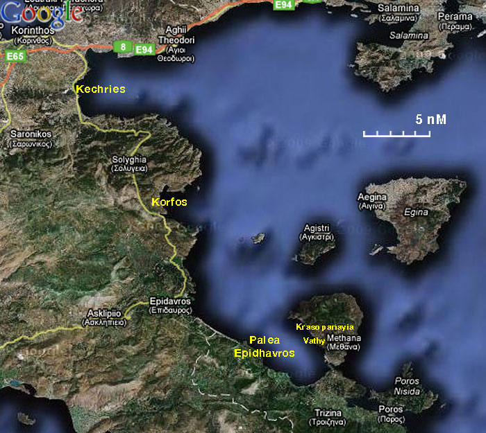

This is region covers the coast of Peloponnese on the Saronikos Gulf. Because of its proximity to Athens it is very popular and crowded.
Charts
- BA
- 1657 Saronikós Kólpos
- Imray-Tetra
- G14 Saronic and Argolic Gulf
- NIMA
- 54344 Saronicos Kolpos & K. Petalion
- Greek
- 413 Saronikos Kolpos
Radio Nets
- Coast Guard - VHF channel 12
- Weather - VHF channel 86
- Olympia Radio - VHF channels 27, 28, and 88
Also see World Cruiser's Nets.
Weather
See Aegean Sea.
Warning: Approaching from the coast of Attika, in the north, you have to cross the shipping lanes. Cross them, if possible, vertically. Do monitor your VHF but most large ships, including ones of the Greek Navy, rarely respond to a hail.
Berthing Options
Ports
Palea Epidhavros
| Palea Epidhavros
| |
 Chart of Palea Epidhavros Harbor - Click for larger view |
Epidhavros (Επίδαυρος) or Palea (Old) Epidhavros is a safe harbor to leave the yacht while attending a performance at the ancient theater of Epidaurus or visiting the Sanctuary of Asklepios. You can take a taxi, 20 min. For a performance make sure you have advanced tickets.
The harbor provides good shelter. You can go stern-to along the quay or anchor off in 5 m. The bottom is mud and weed and provides fairly good holding. Good shopping.
Last Visited & Details Checked (and updated here)
Date of member's visit to this Port/Stop & this page's details validated:
- 1991 --Istioploos

 Travels with S/Y Thetis
- June 2006 --Atheneoflymington 15:33, 12 January 2010 (UTC)
- June 2013 --Vigdis yachtvigdis blog

Vathy
| Vathy
| |
 Vathy harbour - Click for larger view |
Vathy is a small but safe harbour on the west side of the Methana peninsula with room for half a dozen yachts on anchor moor. Shelter is good and depths are 3-5 meters along the quay. There are a couple of small tavernas around the harbour. The bottom is mud and provides good holding.
Last Visited & Details Checked (and updated here)
Date of member's visit to this Port/Stop & this page's details validated:
- June 2006 --Atheneoflymington 15:26, 12 January 2010 (UTC)
Korfos
| Korfos
| |
 Chart of Korfos - Click for larger view |
Korfos (Κόρφος) or Sofiko (Σοφικό) is a pleasant cove in the Saronic Gulf a few miles S of the Corinth Canal. It is now a base for charter boats and during weekends can be crowded. Anchor off in 6-10 m, holding is not always good. There are two restaurant quays with lazy lines on the north west side of the cove and also a small quay but it is very hard to find room there.
Last Visited & Details Checked (and updated here)
Date of member's visit to this Port/Stop & this page's details validated:
- 1990 --Istioploos Travels with S/Y Thetis
- June 2013 --Vigdis yachtvigdis blog
Marinas & Yacht Clubs
None.
Anchorages
Kechries
| Kechries
| |
 Satellite view of Kechrie - Click for larger view |
Kechries (Κεχριές) or Cenchreai is a cove just 2 nM S of Isthmia, the western end of the Corinth Canal. In the antiquity Kechries was the port of the city of Corinth in the Saronikos (Saronic) gulf. The ancient harbor was excavated in the 1960's. A number of of the excavation finds are now exhibited in the Isthmia Museum (I worked as a diver assisting my archaeologist wife for one season of this excavation --Istioploos).
With settled weather you can anchor off in 3-5m depth over sand and rocks and visit the site.
Last Visited & Details Checked (and updated here)
Date of member's visit to this Port/Stop & this page's details validated:
Krasopanayia
Krasopanayia (Κρασοπαναγιά) is very pleasant uninhabited anchorage on the NE side of the Methana Peninsula just across from Epidhavros. It is very convenient and secure anchorage. Unfortunately it has been spoiled by a fish farm. Anchor in 6-10 m and take a line ashore.
Last Visited & Details Checked (and updated here)
Date of member's visit to this Port/Stop & this page's details validated:
Vidhi Bay
See Poros.
Galatas
See Poros.
Aliki Beach
See Poros.
Offshore Islands
Yacht Services and Repairs
Marine Stores
None.
Yacht Services/Repairs/Yards
None.
Fuel, Water, & Electricity
- Fuel
- N/A (Not Available)
- Water
- N/A
- Electricity
- N/A
Things to do Ashore
Tourism
The most interesting place to visit in this region is a visit to Epidhavros. A more ambitious land excursion is to visit Ancient Corinth and Acrocortinth.
Grocery & Supply Stores
- There several stores in Palea Epidhavros
- A few stores in Korfos
Eateries
- Restaurants along the waterfront in Korfos and Palea Epidhavros
Internet/WiFi
In Internet cafés.
Laundry
Motorbike & Car Rentals
Garbage Disposal
There are bins around the harbors and in several anchorages.
Transportation
Transportation to mainland or other countries, etc.
Routes/Passages To/From
Cruiser's Friends
Contact details of "Cruiser's Friends" that can be contacted for local information or assistance.
Forum Discussions
List links to discussion threads on partnering forums. (see link for requirements)
External Links
- Epidhavros (Wikepedia)
- Epidaurus
- Isthmia Museum
References & Publications
See Greece.
Personal Notes
Personal experiences?
Last Visited & Details Checked (and updated here)
See individual ports and anchorages in this page.
| This is a usable page of the cruising guide. However, please contribute if you can to help it grow further. Click on Comments to add your personal notes on this page or to discuss its contents. Alternatively, if you feel confident to edit the page, click on the edit tab at the top and enter your changes directly. |
| |
|---|
|
Names: Istioploos, Athene of Lymington |
| Cruising Wiki Navigation
|
|---|
| | HOMEPAGE | Wiki Contents | Mediterranean | Aegean Sea | Greece | Saronikos Gulf | West Saronikos | |