Zakinthos (Zante)
From CruisersWiki
Istioploos (Talk | contribs) m (→Last Visited & Details Checked (and updated here): Navigation Bar) |
Istioploos (Talk | contribs) (Coords & minor edits) |
||
| Line 38: | Line 38: | ||
====Port Zakinthos==== | ====Port Zakinthos==== | ||
{| | {| | ||
| - | |valign="top"| | + | |valign="top"| GPS: {{Coord|37|47|N|20|54.13|E|}} |
| + | Port Zakinthos is main harbor of Zakinthos it provides good shelter from the prevailing NW wind but with strong S winds there is a bad swell. Anchor in 6-7 m and go stern-to the N mole (inside the jetty). The bottom is mud, good holding. | ||
On the S side of the port a yacht marina is being built but as usual after 12 years it still not finished. | On the S side of the port a yacht marina is being built but as usual after 12 years it still not finished. | ||
| Line 56: | Line 57: | ||
====Ayios Nikolaos==== | ====Ayios Nikolaos==== | ||
{| | {| | ||
| - | |valign="top"|Ayios Nikolaos is nice cove near the NE tip of the island. From here you can go with your dinghy or take a local caïque to the famous [[#Blue_Grotto|Blue Grotto]]. | + | |valign="top"| GPS: {{Coord|37|54.36|N|20|42.6|E|}} |
| + | Ayios Nikolaos is nice cove near the NE tip of the island. From here you can go with your dinghy or take a local caïque to the famous [[#Blue_Grotto|Blue Grotto]]. | ||
Anchor off in 5-10 m near the small island. Reasonable holding. | Anchor off in 5-10 m near the small island. Reasonable holding. | ||
| Line 76: | Line 78: | ||
====Lagana==== | ====Lagana==== | ||
{| | {| | ||
| - | |valign="top"|You may be able to anchor here but | + | |valign="top"|GPS: {{Coord|37|43.58|N|20|53.73|E|}} |
| + | You may be able to anchor here but most likely it is now restricted because it is the breeding area of the endangered loggerhead sea turtles [http://www.zanteguru.com/turtles/turtles.htm Caretta Carreta]. At any rate, in 1989 the beach too developed. Keri was a better option. | ||
|[[Image:Zakinthos_Caretta.jpg|200px|thumb|right|Caretta Caretta<br/>''Click for larger view'']] | |[[Image:Zakinthos_Caretta.jpg|200px|thumb|right|Caretta Caretta<br/>''Click for larger view'']] | ||
| Line 83: | Line 86: | ||
====Keri==== | ====Keri==== | ||
[[Image:Zakinthos_Keri.jpg|200px|thumb|right|Keri from the sea<br/>''Click for larger view'']] | [[Image:Zakinthos_Keri.jpg|200px|thumb|right|Keri from the sea<br/>''Click for larger view'']] | ||
| + | GPS: {{Coord|37|41|N|20|50.47|E|}}<br/> | ||
Keri is a fairly attractive anchorage to the W of Lagana. It is an excellent shelter form the prevailing NW-W winds but exposed to the S and E. Inland are the pitch wells described by [http://en.wikipedia.org/wiki/Herodotus Herodotus] but are not too impressive. | Keri is a fairly attractive anchorage to the W of Lagana. It is an excellent shelter form the prevailing NW-W winds but exposed to the S and E. Inland are the pitch wells described by [http://en.wikipedia.org/wiki/Herodotus Herodotus] but are not too impressive. | ||
| Line 92: | Line 96: | ||
* | * | ||
====Vromi==== | ====Vromi==== | ||
| + | GPS: {{Coord|37|49.08|N|20|37.91|E|}}<br/> | ||
Vromi is deep narrow inlet on the NW side of the island. It is an attractive anchorage that provides reasonable shelter from the the prevailing NW-W winds although it is subjected to strong [http://en.wikipedia.org/wiki/Katabatic katabatic] gusts. The anchorage is not tenable with S winds. The bottom is slate with bad holding. It is better to go deep into the inlet and take two lines ashore, a bow and a stern line. | Vromi is deep narrow inlet on the NW side of the island. It is an attractive anchorage that provides reasonable shelter from the the prevailing NW-W winds although it is subjected to strong [http://en.wikipedia.org/wiki/Katabatic katabatic] gusts. The anchorage is not tenable with S winds. The bottom is slate with bad holding. It is better to go deep into the inlet and take two lines ashore, a bow and a stern line. | ||
| Line 175: | Line 180: | ||
! <h2 id="mp-itn-h2" style="margin:0; background:#cedff2; font-size:120%; font-weight:bold; border:1px solid #a3b0bf; text-align:left; color:#000; padding:0.2em 0.4em;">Cruising Wiki Navigation</h2> | ! <h2 id="mp-itn-h2" style="margin:0; background:#cedff2; font-size:120%; font-weight:bold; border:1px solid #a3b0bf; text-align:left; color:#000; padding:0.2em 0.4em;">Cruising Wiki Navigation</h2> | ||
|- | |- | ||
| - | |style="color:#000;"| | [[Cruising_and_Sailing_Wiki_by_CruiserLog|HOMEPAGE]] | [[Cruising|Wiki Contents]] | [[Med|Mediterranean]] | [[Greece]] | [[Zakinthos (Zante)|Zakinthos]] | | + | |style="color:#000;"| | [[Cruising_and_Sailing_Wiki_by_CruiserLog|HOMEPAGE]] | [[Cruising|Wiki Contents]] | [[Med|Mediterranean]] | [[Ionian Sea]] | [[Greece]] | [[Zakinthos (Zante)|Zakinthos]] | |
|} | |} | ||
. | . | ||
Revision as of 22:08, 12 February 2009
Zakinthos or Zante (Port of Entry)
Click for larger view
Background
Zakinthos (Ζάκυνθος) or Zakynthos or Zante is the southernmost of the Ionian Islands or Eptanesa (7 islands). Zakinthos, along the rest of the Ionian island, has been ravaged by frequent earthquakes.
The island has a long history. It takes its name from Zakynthus the son of the king of Phrygia Dardanus. Zakynthus came from the city of Psophis in Arcadia, where his brothers reigned, to colonize the island. He built an acropolis, probably at the location where the Venetian castle is today, which he named Psophida. According to Pausanias and Thucydides this happened around 1500 BC. It is believed that Zakinthos was part of the Odysseus kingdom of Ithaka. The islanders worshiped Apollo and Artemis. During the Peloponnesian War Zakinthos was a member of the Athenian alliance until it was conquered by the Spartans.
During Roman times Zakinthos had some autonomy and prospered but in the late Roman period it was frequently raided by pirates, Goths, Vandals and Arabs and its fortunes declined. Later it became part of the Byzantine Empire. During the Crusades it was overtaken by the Franks and in 1185 the Palatine County of Cephalonia and Zante was found, which survived for three centuries under the Orsini Family. In 1479 it was occupied by the Ottomans who held it until 1485 when they were replaced by the Venetians.
The Venetians dominated the island until 1797 when the post revolution French took over the island and proclaimed it republic. This state of affairs did not last more then 15 months. In 1800 the two powers decided to establish an independent state under the name "The Septinsular Republic" under the supervision of Russia and Turkey, the first modern Greek state. In 1807 France reconquered the island to be succeeded two years later by the British who held the island ("The United States of the Ionian Islands") until 1864 then it became part of Modern Greece.
During WW II the island was occupied by the Italians and later by the Germans who held it until 1945. In 1953 a terrible earthquake shook the Ionian islands and cause massive destructions in Zakinthos. Since then it has been rebuilt but many charming old buildings have perished.
Zakynthos is the birth place of the poet Dionysios Solomos (1798-1857) who wrote the Hymn to Liberty, the Greek national anthem.
Charts
BA 203 Nisos Zakinthos to Nisos Paxoi
Imray-Tetra G12 Nísos Levkas to Nísos Zákinthos
NIMA 54280 Corfu Channel to Nisis Proti
Greek 2 Ionio Pelagos
Greek 22 Ionio Sea - Southern Part
Radio Nets
Also see World Cruiser's Nets
- Coast Guard - VHF channel 12 & Tel. +30 26950 28117
- Olympia Radio - VHF channels 03 & 86
Approaches to Zakinthos are straightforward.
Ports and Popular Stops
There is only one harbor in the island, Port Zakinthos, but there are several good anchorages.
Port Zakinthos
| GPS: 37°47′N, 20°54.13′E
Port Zakinthos is main harbor of Zakinthos it provides good shelter from the prevailing NW wind but with strong S winds there is a bad swell. Anchor in 6-7 m and go stern-to the N mole (inside the jetty). The bottom is mud, good holding. On the S side of the port a yacht marina is being built but as usual after 12 years it still not finished. Last Visited & Details Checked (and updated here)Date of member's visit to this Port/Stop & this page's details validated:
Marinas & Yacht ClubsNone (see above). |
Anchorages
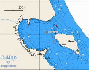
Ayios Nikolaos
| GPS: 37°54.36′N, 20°42.6′E
Ayios Nikolaos is nice cove near the NE tip of the island. From here you can go with your dinghy or take a local caïque to the famous Blue Grotto. Anchor off in 5-10 m near the small island. Reasonable holding. Danger: While entering the cove avoid the reef on the N of the small island. Warning: Around 1 PM a strong gusty wind blows. If you only want to visit the Blue Grotto and the weather permits you can temporarily anchor near the last cave. Last Visited & Details Checked (and updated here)Date of member's visit to this Port/Stop & this page's details validated:
|
Lagana
| GPS: 37°43.58′N, 20°53.73′E
You may be able to anchor here but most likely it is now restricted because it is the breeding area of the endangered loggerhead sea turtles Caretta Carreta. At any rate, in 1989 the beach too developed. Keri was a better option. |
Keri
GPS: 37°41′N, 20°50.47′E
Keri is a fairly attractive anchorage to the W of Lagana. It is an excellent shelter form the prevailing NW-W winds but exposed to the S and E. Inland are the pitch wells described by Herodotus but are not too impressive.
Anchor in 2-4 m on either side of the stone mole. The bottom has some boulders and holding is not everywhere reliable. Best snorkel to check your anchor.
Last Visited & Details Checked (and updated here)
Date of member's visit to this Port/Stop & this page's details validated:
- 1989 --Istioploos 13:52, 27 June 2008 (MDT)
Vromi
GPS: 37°49.08′N, 20°37.91′E
Vromi is deep narrow inlet on the NW side of the island. It is an attractive anchorage that provides reasonable shelter from the the prevailing NW-W winds although it is subjected to strong katabatic gusts. The anchorage is not tenable with S winds. The bottom is slate with bad holding. It is better to go deep into the inlet and take two lines ashore, a bow and a stern line.
Routes/Passages To/From
Popular passages/routes, timing, etc.
Tourism & things to do ashore
Town of Zakinthos
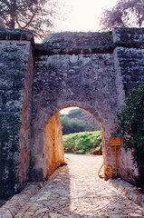
It is worth visiting the restored Venetian Fortress of Zakinthos. Also in town there are two worthwhile museums: the Byzantine Museum which houses many icons and paintings and the Dionysios Solomos Museum dedicated to the poets Dionysios Solomos and Andreas Kalvos as well as other noteworthy Zakinthians.
MonasteriesThere two monasteries in the island of some interest: the post-Byzantine Monastery of Aghios Ioannes Prodromos (St. John the Baptist) about 20 km from the town, and the 15 th century Monastery of Theotokos about 25 km from the town. |
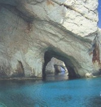
Blue Grotto
The Blue Grotto, near Ayios Nikolaos, is maybe the most famous site in the island. In my opinion this rather overrated. Nevertheless if you are in Ayios Nikolaos it is worth a visit. Alternatively, and if the weather permits, you can temporarily anchor near the last cave and snorkel.
Fuel, Water, & Electricity
- Fuel - On the quay of Port Zakinthos
- Water - On the quay of Port Zakinthos
- Electricity - N/A
Laundry
Grocery & Supply Stores
- Several supermarkets in the town.
Eateries
- Many tavernas in the town.
Internet/WiFi
In cafés.
Motorbike & Car Rentals
In the town.
Marine Stores & Facilities
In the town there are some modest stores.
Repairs
Only Minor.
Transportation
There are daily flights to Athens and ferries to Kyllini and Kefalonia.
References & Publications
See Greece.
Cruiser's Friends
Contact details of "Cruiser's Friends" that can be contacted for local information or assistance.
Forum Discussions
List links to discussion threads on the Cruiser Log Forum
External Links
- Zakinthos (Wikipedia)
- Ionian Islands
- Caretta Carreta
Personal Notes
Personal experiences?
Last Visited & Details Checked (and updated here)
See individual ports in this page.
| |
|---|
| | HOMEPAGE | Wiki Contents | Mediterranean | Ionian Sea | Greece | Zakinthos | |
.


