Susak
From CruisersWiki
An online cruising guide for yachts sailing to Susak Island in Croatia
| Susak
| |
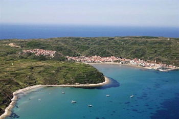
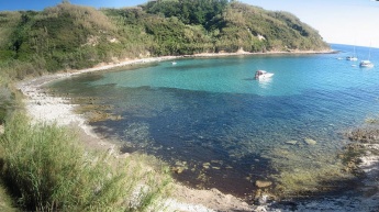
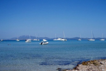
The small island of Susak is situated some 30 miles off the mainland coast of Croatia and six miles W of the much larger island of Losinj. Together with the island of Unije, it is the westernmost of the northern Croatian islands. Although the closest island to the area of the Italian coast around Ravenna, Susak is not a port of entry and a foreign yacht arriving from Italy will need to continue to Mali Losinj to clear in. Only 1.5 square miles in area, the island supports a population of under 200, mostly in the main settlement of Susak Town, which is divided between the main village on a hill and the harbour of Luka Susak. The harbour is very popular with tripper boats from Losinj and visiting yachts need to squeeze in wherever they can. There is also a good anchorage at the NW end of the island, U. Porat, which can be used overnight in settled weather and another immediately E of the bay of Luka Susak, U. Dragoca, which is also for settled conditions only.
Charts
- British Admiralty
- 202
- Croatian charts
- MK8
- Imray
- M24
Weather
See Croatia.
Passages
See Croatia.
Islands
Communication
Add here VHF channel for coastguard, harbor masters. etc.
Also see World Cruiser's Nets
Add any navigation notes such approaches, dangers etc here. If this section does not apply remove it.
Berthing
There are three berthing options on the island, the harbour of Luka Susak and the anchorages of U. Porat and U. Dragoca (see below).
Ports
Luka Susak
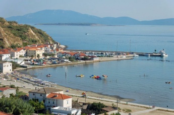
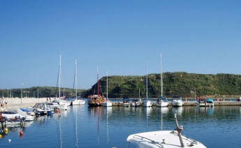
The harbour of Luka Susak gets very busy with tripper boats in the season and it can sometimes be difficult to find space. The only spots where a yacht may be able to squeeze in are stern/bows-to the inner side of the S breakwater, where depths are 3.0 - 3.5 metres and the holding moderate to good in sand and weed, or alongside the inner end of the N breakwater in 2.5 metres, avoiding the rock ballasting further along the breakwater. Note that ferries and tripper boats berth on the very end of the N breakwater. Shelter in the harbour is good in all conditions except strong E winds. Ashore there is a simple provisions store but no other facilities.
Danger: the remains of a ruined breakwater extend in an ‘L’ from the root of the S breakwater for some 400 metres E of the harbour. Most of the remains are underwater and the N end is marked with a red marker buoy. Do not attempt to enter the harbour or manoeuvre S of this buoy.Marinas & Yacht Clubs
None.
Anchorages
U. Porat
U. Dragoca
Facilities
Water
N/A (Not Available).
Electricity
N/A.
Toilets
?
Showers
?
Laundry
None.
Garbage
?
Supplies
Fuel
No fuel.
Cooking gas
None.
Chandlers
None.
Services
Repairs
None.
Internet
N/A.
Mobile connectivity
Is there mobile telephone signal such as G4, G3, GPRS in the island? How strong is the signal? Are there any blind spots?
Vehicle Rentals
N/A.
Provisioning
![]() Luka Susak [[Susak#Luka Susak|Luka Susak]] 44°30.752'N, 014°18.654'E small provisions store.
Luka Susak [[Susak#Luka Susak|Luka Susak]] 44°30.752'N, 014°18.654'E small provisions store.
Transportation
Ferries to Mali Losinj.
Eating out
- Please specify POI name
 [[Susak# | ]] 44°30.752'N, 014°18.654'E Two small restaurantsnear the harbour.
- In the village
- Please specify POI name
 [[Susak# | ]] Others up the hill.
Tourism
Places to Visit
The settlement of Susak is pleasant enough to explore and the landscape of the island is unusual, being mostly composed of sand dunes and terraced slopes which still support a small local wine industry.
Friends
Contact details of "Cruiser's Friends" that can be contacted for local information or assistance.
Forums
List links to discussion threads on partnering forums. (see link for requirements)
Links
- Susak at the Wikipedia
- Susak tourism
- List of all Croatian marinas
- List of government-owned ACI marinas
- Croatian National Tourist Board
- Find Croatia travel guide
- Wikipedia - Croatia
References
See Croatia.
Comments
We welcome users' contributions to the Wiki. Please click on Comments to view other users' comments, add your own personal experiences or recommend any changes to this page following your visit.
Verified by
Date of member's last visit to Susak and this page's details validated:
- July 2004 --Athene of Lymington 15:04, 21 April 2012 (BST)
| This is a usable page of the cruising guide. However, please contribute if you can to help it grow further. Click on Comments to add your personal notes on this page or to discuss its contents. Alternatively, if you feel confident to edit the page, click on the edit tab at the top and enter your changes directly. |
| |
|---|
|
Names: Athene of Lymington |
