Adriatic Sea
From CruisersWiki
Adriatic Sea Cruising Guide
An online cruising guide for yachts sailing in the Adriatic Sea.
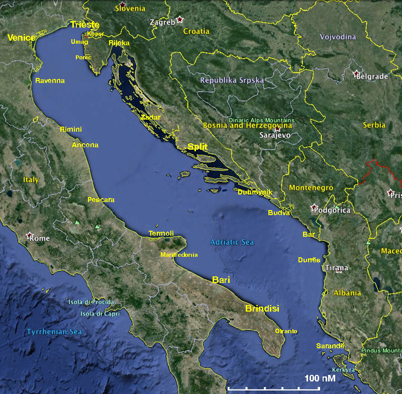

The Asriatic Sea is between the Italian peninsula and the Balkan peninsula. The name is derived from the Etruscian colony of Hadria.
Wikipedia describes its extent and bathymetry as:
The Adriatic extends northwest from 40° to 45°45' North, with an extreme length of about 770 km (415 nm, 480 mi). It has an average width of about 160 km (85 nm, 100 mi), although the Strait of Otranto, through which it connects at the south with the Ionian Sea, is only 45-55 nautical miles wide (85–100 km).
Moreover, the chain of islands which fringes the northern part of the eastern shore reduces the extreme breadth of open sea in this part to 145 km (78 nm, 90 mi). Its total surface area is about 60,000 square miles (160,000 km²).
The International Hydrographic Organization defines the southern limit of the Adriatic Sea as "A line running from the mouth of the Butrinto River (39°44'N) in Albania to Cape Karagol in Corfu, through this island to Cape Kephali (these two capes are in lat. 39°45'N) and on to Cape Santa Maria di Leuca".[4]
The depths of the Adriatic near its shores share a close relationship to the physiography of the nearby coastlines. Wherever the coasts are high and mountainous, the nearby sea depths are considerable. For instance, in the case of the Istrian and Dalmatian areas of Slovenia and Croatia the shores are low and sandy and the nearby sea is shallow, as in the vicinity of Venice or, farther south, near the delta of the Italian Po River. Generally speaking, the waters are shallow all along the Italian coast. The maximum depth of the Adriatic Sea is 3,300 feet (1.0 km) and is situated south of the central area. The average depth is 1,457 feet (0.444 km).
- Source
- Chart Number - Chart Name
- Chart Number - Chart Name
- Source
- Chart Number - Chart Name
Weather and Winds
See Italy, Croatia, Montenegro or Albania pages.
Sources for weather information:
See Italy, Croatia, Montenegro or Albania pages.
Currents & Tides
Details?
Regional Radio Nets
Also see World Cruiser's Nets.
Countries, Groups, Ports, and Islands
There are numerous ports of entry, some of them open only in season. See country pages for details.
The eastern coast - especially that of Croatia - has numerous beautiful islands of all sizes. A notable chain of islands is Susac (Croatia) - Palagruza (Croatia) - Pianosa (Italy). By sailing along this chain one can cross the Adriatic in the middle while remaining within the 12 nM coastal navigation limit.
The countries and principal harbours around the Adriatic Sea are as follows (see country pages for full list of harbours):
| Italy | Slovenia | Croatia | Bosnia & Herzegovina | Montenegro | Albania |
![]() = Port of Entry,
= Port of Entry, ![]() = Island,
= Island, ![]() = Marina,
= Marina, ![]() = Harbor,
= Harbor, ![]() = Anchorage,
= Anchorage, ![]() = Needs data.
= Needs data.
Routes/Passages To/From
Due to the relatively small area of the Adriatic, it is not meaningful to talk about passages in the usual sense, since most cruisers crossing the Adriatic complete their passage in 12-15 hours. There are major ferry routes along the axis of the sea, between Ancona and Zadar, and between Bari and Dubrovnik. Popular routes for cruisers across the Adriatic are Bari to Dubrovnik; Pescara to Vis; Vieste to Lastovo; Ancona to Mali Losinj and (further north) from Ravenna to Pula and Venice to Umag. The Susac-Palagruza-Pianosa route is another possibility.
Cruiser's Friends
Contact details of "Cruiser's Friends" that can be contacted for local information or assistance.
Forum Discussions
List links to discussion threads on partnering forums. (see link for requirements)
External Links
References & Publications
- Rod Heikell, Italian Waters Pilot, Imray ,Laurie, Norie & Wilson, Cambridgeshire; 8th Revised edition edition (April 1, 2011), ISBN 9781846233326 - Covers the coasts of the Tyrrhenian Sea, Sardinia, Sicily, the Ionian 'heel' and Malta
- Trevor and Dinah Thompson, Adriatic Pilot - Croatia, Slovenia, Montenegro, east coast of Italy, Albania, Imray ,Laurie, Norie & Wilson, Cambridgeshire; 6th (2012), ISBN 9781846233333
- Sonia Florian, Dario Silvestro, Piero Magnabosco, 777 Harbours and Anchorages - Croatia, Slovenia, Montenegro and Albania, Edizioni Magnamare (6th edition 2014/15), ISBN 9788862000345 [1]
- Jane Cody & John Nash, Croatia Cruising Companion, Wiley Nautical (reprinted 2010), ISBN 978-1904358282
- Hrvatski Hidrografski Institut, Adriatic Sea Pilot Volume 2, Croatian Hydrographic department, ISBN 9536165317
- Hrvatski Hidrografski Institut, Adriatic Sea Pilot Volume 1, Croatian Hydrographic department, ISBN 9536165325
- Zavod Leksikografski, Navigational Guide to the Adriatic, Imray Laurie Norie & Wilson, ISBN 9789536036875
- Radovan Marčić & Braslav Karlić, A Gourmet Cruise; The Adriatic Good Food Pilot, Gustoza đita (3rd Edition 2010), ISBN 9789537131043
Personal Notes
|
|---|
|
Names: Lighthouse, Magwas, Haiqu, Istioploos, Athene of Lymington |
| |
|---|
| | HOMEPAGE | Wiki Contents | Mediterranean | Italy | Slovenia | Croatia | Montenegro | Albania | Adriatic Sea | |