Malinska
From CruisersWiki
Istioploos (Talk | contribs) m (Reverted edits by Riley Huntley (talk) to last revision by Atheneoflymington) |
Istioploos (Talk | contribs) (Template) |
||
| (23 intermediate revisions not shown) | |||
| Line 1: | Line 1: | ||
| - | + | {{IsPartOf|Mediterranean|Adriatic Sea|Croatia|Kvarner Gulf|Krk}} | |
| - | {{ | + | {{TOC block}} |
| - | + | ||
| - | | | + | {{Infobox |
| - | | | + | | lat= 45.12516|lon=14.52483 |
| - | + | | name= Malinska | |
| - | + | | portofentry= | |
| - | + | | zoom= 15 | |
| - | + | | chartlet = y | |
| - | + | | image= Malinska.jpg | |
| - | | | + | | imagetext= Malinska harbour from the N |
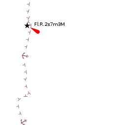
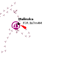
| - | | | + | | summary= The harbour of '''Malinska''' (or, to give it its full name Malinska-Dubasnica) is situated on the NW coast of the island of Krk in Croatia, around 18 miles by sea NW of the island’s main harbour of [[Krk Town]]. The town has a small commercial harbour with a pier and quays where a yacht can usually find space and a long pontoon owned by a leisure development where a yacht may be able to moor. Malinksa lies at the E side of a large bay open to NW and W and would not be a suitable port of call in strong winds from this direction. |
| - | + | | notes= | |
| - | | | + | | news= |
| - | | | + | }} |
| - | | | + | |
| - | + | ||
| - | | | + | |
| - | The harbour of Malinska (or, to give it its full name Malinska-Dubasnica) is situated on the NW coast of the island of Krk in Croatia, around 18 miles by sea NW of the island’s main harbour of [[Krk Town]]. The town has a small commercial harbour with a pier and quays where a yacht can usually find space and a long pontoon owned by a leisure development where a yacht may be able to moor. Malinksa lies at the E side of a large bay open to NW and W and would not be a suitable port of call in strong winds from this direction. | + | |
| - | + | ||
==Charts== | ==Charts== | ||
| - | + | ''See [[Krk#Charts|Krk]]''. | |
| - | + | ==Weather== | |
| + | ''See [[Croatia#Weather|Croatia]]''. | ||
| - | + | ==Passages== | |
| + | ''See [[Croatia#Passages|Croatia]]''. | ||
| - | == | + | ==Islands== |
| - | + | * [[Losinj]] | |
| + | * [[Cres]] | ||
| + | * [[Rab]] | ||
| - | + | ==Communication== | |
| + | {{Green|Add here VHF channel for coastguard, harbor masters. etc.}} | ||
| + | * | ||
| + | * | ||
| - | + | ''Also see [[World MM Nets|World Cruiser's Nets]]'' | |
| - | == | + | ==Navigation== |
The town is easily identified in the approach from N the buildings of the town and the long, sandy spit that fronts a long breakwater providing the harbour with some protection from N. A red buoy marks the end of the breakwater. In the approach from W, be sure not to confuse Malinska harbour with the small harbour a mile SW, which is not suitable for a yacht. Once round the breakwater, if heading for the pier and quay at the SW end of the harbour, avoid the shallow patch 50 metres off the quay which is marked with a black pillar mark. | The town is easily identified in the approach from N the buildings of the town and the long, sandy spit that fronts a long breakwater providing the harbour with some protection from N. A red buoy marks the end of the breakwater. In the approach from W, be sure not to confuse Malinska harbour with the small harbour a mile SW, which is not suitable for a yacht. Once round the breakwater, if heading for the pier and quay at the SW end of the harbour, avoid the shallow patch 50 metres off the quay which is marked with a black pillar mark. | ||
| - | == | + | ==Entrance== |
| - | Malinska is not a port of entry. The nearest port of entry is [[Mali Losinj]] on the island of [Losinj]]. | + | [[Malinska]] is not a port of entry. The nearest port of entry is [[Mali Losinj]] on the island of [Losinj]]. |
| - | ==Berthing | + | ==Berthing== |
| - | The best berth for a visiting yacht (if there is space) is alongside either of the two short piers at the NE and SW sides of the harbour. Depths here are unknown, but large commercial vessels moor here so are likely in excess of 8.0 metres. Alternatively, use your anchor to go bows or stern-to the quay at the SW end of the harbour. There is also a long pontoon running parallel with the shore at the N end of the harbour, which is owned by a hotel and leisure development, and it may be possible to negotiate a berth there. | + | {{poi | lat= 45.12526|lon=14.52618 |
| - | + | | type= harbour | |
| + | | name= Malinska Harbour | ||
| + | | altname= | ||
| + | | url = | ||
| + | | zoom= 17 | ||
| + | | portofentry= | ||
| + | | image= MalinskaHarbour.jpg | ||
| + | | imagetext= Malinska harbour from the W | ||
| + | | text= The best berth for a visiting yacht (if there is space) is alongside either of the two short piers at the NE and SW sides of the harbour. Depths here are unknown, but large commercial vessels moor here so are likely in excess of 8.0 metres. Alternatively, use your anchor to go bows or stern-to the quay at the SW end of the harbour. There is also a long pontoon running parallel with the shore at the N end of the harbour, which is owned by a hotel and leisure development, and it may be possible to negotiate a berth there. | ||
| + | }} | ||
| - | = | + | ===Marinas & Yacht Clubs=== |
| - | + | ||
| - | + | ||
| - | + | ||
| - | + | ||
| - | ==Marinas & Yacht Clubs== | + | |
None. | None. | ||
| Line 54: | Line 61: | ||
It may be possible to drop anchor temporarily off the long pontoon if going ashore for supplies, but Malinska does not offer a suitable overnight anchorage unless the weather is very settled. | It may be possible to drop anchor temporarily off the long pontoon if going ashore for supplies, but Malinska does not offer a suitable overnight anchorage unless the weather is very settled. | ||
| - | == | + | ==Amenities== |
| - | + | {{tlist | |
| - | + | ||
| - | + | |header|Facilities | |
| - | + | ||
| - | + | |Water| Water along the SW quay and on the long pontoon | |
| - | + | |Electricity| Electricity along the SW quay and on the long pontoon | |
| + | |Toilets| N/A (Not Available) | ||
| + | |Showers| N/A | ||
| + | |Laundry| In the town | ||
| + | |Garbage| Bins near the harbour | ||
| - | + | |header|Supplies | |
| - | + | |Fuel| Fuel from garages in the town only | |
| - | + | |Bottled gas| {{MagentaText|?}} | |
| - | + | |Chandlers| None | |
| - | + | ||
| - | + | ||
| - | + | ||
| - | + | ||
| - | + | ||
| - | + | ||
| - | + | ||
| - | None | + | |
| - | + | |header|Services | |
| - | + | |Repairs| N/A, got to [[Marina Punat]] | |
| + | |Internet| N/A | ||
| + | |Mobile connectivity| {{MagentaText|?}} | ||
| + | |Vehicle rentals| Rental outlets in the town | ||
| + | }} | ||
| - | == | + | ==Provisioning== |
| - | + | Supermarket and good provisions shops in the town. | |
| - | == | + | ==Eating out== |
| - | + | Numerous cafes and restaurants around the harbour and in the town. | |
| - | + | ==Transportation== | |
| - | + | ||
* Buses to [[Rijeka]] and Zagreb. | * Buses to [[Rijeka]] and Zagreb. | ||
* Local buses to Krk Town, Vrbnik and Biska. | * Local buses to Krk Town, Vrbnik and Biska. | ||
| - | == | + | ==Tourism== |
| - | + | ====History==== | |
| - | + | {{Green|Give a short history of the port.}} | |
| + | |||
| + | ====Places to Visit==== | ||
| + | Malinska, while not unattractive, is primarily a resort town and not a destination in its own right. | ||
| - | == | + | ==Friends== |
Contact details of "Cruiser's Friends" that can be contacted for local information or assistance. | Contact details of "Cruiser's Friends" that can be contacted for local information or assistance. | ||
* | * | ||
| - | == | + | ==Forums== |
| - | List links to discussion threads on [[Cruising Forums|partnering forums]]. (see link for requirements) | + | List links to discussion threads on [[Cruising Forums|partnering forums]]. (''see link for requirements'') |
* | * | ||
| - | == | + | ==Links== |
| + | * {{wikipedia}} | ||
| + | * {{Wikivoyage}} | ||
* [http://www.about-croatia.com/croatia-marina.php List of all Croatian marinas] | * [http://www.about-croatia.com/croatia-marina.php List of all Croatian marinas] | ||
| - | |||
* [http://croatia.hr/en-GB/Homepage Croatian National Tourist Board] | * [http://croatia.hr/en-GB/Homepage Croatian National Tourist Board] | ||
| - | * [http://www.find-croatia.com Find Croatia travel guide] | + | * [http://www.find-croatia.com Find Croatia travel guide] |
| - | * | + | * |
| - | ==References | + | ==References== |
| - | + | ''See entry for [[Croatia#References|Croatia]]''. | |
| - | + | ||
| - | + | ||
| - | + | ||
| - | + | {{Comments}} | |
| - | + | * | |
* | * | ||
| - | + | {{Verified by}} | |
| - | + | ||
* May 2005 --[[User:Atheneoflymington|Athene of Lymington]] 16:24, 24 April 2012 (BST) | * May 2005 --[[User:Atheneoflymington|Athene of Lymington]] 16:24, 24 April 2012 (BST) | ||
| + | * | ||
| + | {{Page useable}} | ||
| - | |||
| - | |||
| - | |||
| - | |||
| - | |||
| - | |||
| - | |||
| - | |||
| - | |||
| - | |||
| - | |||
| - | |||
| - | |||
| - | |||
| - | |||
| - | |||
| - | |||
| + | {{Contributors|[[User:Atheneoflymington|Athene of Lymington]]}} | ||
[[Category:Ports - Croatia]] | [[Category:Ports - Croatia]] | ||
Latest revision as of 21:53, 4 March 2019
| Malinska
| |
| |
 Malinska harbour from the N |
The harbour of Malinska (or, to give it its full name Malinska-Dubasnica) is situated on the NW coast of the island of Krk in Croatia, around 18 miles by sea NW of the island’s main harbour of Krk Town. The town has a small commercial harbour with a pier and quays where a yacht can usually find space and a long pontoon owned by a leisure development where a yacht may be able to moor. Malinksa lies at the E side of a large bay open to NW and W and would not be a suitable port of call in strong winds from this direction.
Charts
See Krk.
Weather
See Croatia.
Passages
See Croatia.
Islands
Communication
Add here VHF channel for coastguard, harbor masters. etc.
Also see World Cruiser's Nets
The town is easily identified in the approach from N the buildings of the town and the long, sandy spit that fronts a long breakwater providing the harbour with some protection from N. A red buoy marks the end of the breakwater. In the approach from W, be sure not to confuse Malinska harbour with the small harbour a mile SW, which is not suitable for a yacht. Once round the breakwater, if heading for the pier and quay at the SW end of the harbour, avoid the shallow patch 50 metres off the quay which is marked with a black pillar mark.
Entrance
Malinska is not a port of entry. The nearest port of entry is Mali Losinj on the island of [Losinj]].
Berthing

Malinska Harbour
Marinas & Yacht Clubs
None.
Anchorages
It may be possible to drop anchor temporarily off the long pontoon if going ashore for supplies, but Malinska does not offer a suitable overnight anchorage unless the weather is very settled.
Amenities
| Facilities | |
|---|---|
| Water | Water along the SW quay and on the long pontoon |
| Electricity | Electricity along the SW quay and on the long pontoon |
| Toilets | N/A (Not Available) |
| Showers | N/A |
| Laundry | In the town |
| Garbage | Bins near the harbour |
| Supplies | |
| Fuel | Fuel from garages in the town only |
| Bottled gas | ? |
| Chandlers | None |
| Services | |
| Repairs | N/A, got to Marina Punat |
| Internet | N/A |
| Mobile connectivity | ? |
| Vehicle rentals | Rental outlets in the town |
Provisioning
Supermarket and good provisions shops in the town.
Eating out
Numerous cafes and restaurants around the harbour and in the town.
Transportation
- Buses to Rijeka and Zagreb.
- Local buses to Krk Town, Vrbnik and Biska.
Tourism
History
Give a short history of the port.
Places to Visit
Malinska, while not unattractive, is primarily a resort town and not a destination in its own right.
Friends
Contact details of "Cruiser's Friends" that can be contacted for local information or assistance.
Forums
List links to discussion threads on partnering forums. (see link for requirements)
Links
- Malinska at the Wikipedia
- Malinska at the Wikivoyage
- List of all Croatian marinas
- Croatian National Tourist Board
- Find Croatia travel guide
References
See entry for Croatia.
Comments
We welcome users' contributions to the Wiki. Please click on Comments to view other users' comments, add your own personal experiences or recommend any changes to this page following your visit.
Verified by
Date of member's last visit to Malinska and this page's details validated:
- May 2005 --Athene of Lymington 16:24, 24 April 2012 (BST)
| This is a usable page of the cruising guide. However, please contribute if you can to help it grow further. Click on Comments to add your personal notes on this page or to discuss its contents. Alternatively, if you feel confident to edit the page, click on the edit tab at the top and enter your changes directly. |
| |
|---|
|
Names: Athene of Lymington |