Osor
From CruisersWiki
Lighthouse (Talk | contribs) (Minor edit) |
Istioploos (Talk | contribs) (Template) |
||
| (37 intermediate revisions not shown) | |||
| Line 1: | Line 1: | ||
| - | + | {{IsPartOf|Mediterranean|Adriatic Sea|Croatia|Kvarner Gulf|Cres}} | |
| - | {| | + | {{TOC block}} |
| - | | | + | |
| - | | | + | {{Infobox |
| - | + | | lat= 44.69257|lon=14.39316 | |
| - | + | | name= Osor | |
| - | + | | portofentry= | |
| - | | | + | | zoom= 15 |
| - | + | | chartlet = y | |
| - | | | + | | image= OsorAerial.jpg |
| - | | | + | | imagetext= Osor from the NW |
| - | + | | summary= The village of '''Osor''' lies on the SW coast of the island of [[Cres]] in [[Croatia]], on the E side of a narrow channel separating Cres from the island of [[Losinj]] immediately to the W. Originally joined to Losinj, the channel was dug by the Romans, who also constructed the settlement of Osor nearby. The settlement fell into disuse with the increasing size of cargo vessels plying the trade routes along the coast and Osor remained something of a ghost village until the advent of tourism. The channel is spanned by a swing bridge and shallow draft yachts can pass through here, although depths on the S side of the channel shoal in parts to as little as 2.5 metres. | |
| - | | | + | | notes= |
| - | | | + | | news= |
| - | + | }} | |
| - | + | ||
| - | + | ||
==Charts== | ==Charts== | ||
| - | + | ''See [[Cres#Charts|Cres]]''. | |
| - | + | ==Weather== | |
| + | ''See [[Croatia#Weather|Croatia]]''. | ||
| - | + | ==Passages== | |
| + | ''See [[Croatia#Passages|Croatia]]''. | ||
| - | == | + | ==Islands== |
| - | + | * [[Losinj]] | |
| - | + | ==Communication== | |
| + | {{Green|Add here VHF channel for the coastguard, harbor masters. etc.}} | ||
| + | * | ||
| + | * | ||
| - | + | ''Also see [[HF_Radio|Cruiser's Nets]]'' | |
| - | == | + | {{hold vertical}} |
| - | + | ==Navigation== | |
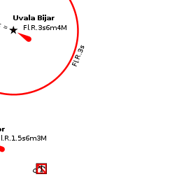
| - | + | {{thumb|Osor-otocny most pres pruplav mezi Cresem a Losinjem.jpg|Moveable bridge in Osor (looking from N)}} | |
| - | + | There are no dangers in the approach from N. In the approach from W, a yacht should keep at least half a mile off the headland of Rt. Osor to avoid rocky shallows marked with a N cardinal mark. In the approach from S, the depths shoal progressively until entering the narrow channel up to Osor, which is marked by a series of beacons on the W side. | |
| - | + | ||
| - | + | Depths in the channel are variable, with least depths of about 3.5 meters. Currents can be strong in the channel from either direction, depending on the tides, and have been reported to reach 6.0 knots at times. At Osor, the channel is 6.0 metres wide and has a depth of 2.5 metres. A swing bridge crosses the channel. | |
| - | + | ||
| - | + | ||
| - | == | + | {{mark |
| - | + | |type=waypoint | |
| + | | name= Osorski most | altname= Osor bridge | url=http://www.luckauprava-losinj.hr/en/bridges-and-cranes.html | ||
| + | | lat=44.692752 | lon=14.392412 | ||
| + | | text= opens every day at 9:00 and 17:00. Vessels coming from the South have priority. In the case of strong winds the bridge may be closed due to dangerous current and waves. | ||
| + | }} | ||
| - | == | + | ==Entrance== |
| - | + | The nearest port of entry is [[Mali Losinj]] on the island of [[Losinj]]. | |
| + | |||
| + | {{hold vertical}} | ||
| + | ==Berthing== | ||
| + | {{Image right|OsorMoorings.jpg |Pontoon moorings S of Osor bridge }} | ||
| + | A yacht can moor alongside the quay on the N side of the bridge, where there are depths of 3.0 - 3.5 metres, for a visit to the town. The berth here is only suitable in settled weather, however, as there is a dangerous swell with any strong winds from N. On the S side of the bridge there is a pontoon in depths of 2.0 - 2.5 metres where it may be possible for a shallow draft visiting yacht to moor temporarily stern/bows-to among the local boats. There are laid moorings on the pontoon. Shelter here is good in the prevailing winds but poor with southerlies. | ||
| - | === | + | ===Marinas & Yacht Clubs=== |
None. | None. | ||
| - | == | + | ==Anchorages== |
| - | + | ||
None. | None. | ||
| - | == | + | ==Amenities== |
| - | + | {{tlist | |
| - | + | |header|Facilities | |
| - | + | ||
| - | + | |Water| N/A (Not Available) | |
| - | + | |Electricity| N/A | |
| - | + | |Showers| N/A | |
| - | + | |Laundry| N/A | |
| - | + | |Garbage| Bins in the village | |
| - | + | ||
| - | + | ||
| - | + | |header|Supplies | |
| - | + | |Fuel| N/A | |
| - | + | |Bottled gas| N/A | |
| + | |Chandlers| None | ||
| - | + | |header|Services | |
| - | + | |Repairs| N/A | |
| + | |Internet| N/A | ||
| + | |Mobile connectivity| {{MagentaText|?}} | ||
| + | |Vehicle rentals| N/A | ||
| + | }} | ||
| - | == | + | ==Provisioning== |
| - | + | Small grocery shop in the village. | |
| - | ==== | + | ==Eating out== |
| - | + | * Several restaurants in the village. | |
| + | * The ''Konoba Livio'' has a vine-shaded terrace and is excellent for seafood and very tasty local draught white wine. | ||
| - | == | + | ==Transportation== |
| - | + | Buses to [[Cres Town]]. | |
| - | ==== | + | ==Tourism== |
| - | + | {{Image right|OsorTown.jpg |Osor village square }} | |
| - | + | {{Image right|OsorSculpture.jpg |Sculpture in Osor square }} | |
| + | ====Places to Visit==== | ||
| + | The village of Osor has been beautifully restored over the years and resembles nothing less than an open-air museum today. It is a delight to explore on foot, its main square lined with 15th and 16th century stone houses and decorated with sculptures by several of Croatia’s leading artists. Parts of the original Roman walls still survive and the former town hall, with a beautiful Venetian loggia, is now a museum. The village also contains a restored bishop’s palace and impressive cathedral with a Venetian bell tower. A few hundred metres N along the coast is Bijar cove, a small bay with a ruined Franciscan monastery with Glagolitic inscriptions on its bell tower. | ||
| - | == | + | ==Friends== |
Contact details of "Cruiser's Friends" that can be contacted for local information or assistance. | Contact details of "Cruiser's Friends" that can be contacted for local information or assistance. | ||
* | * | ||
| - | == | + | ==Forums== |
| - | List links to discussion threads on [[Cruising Forums|partnering forums]]. (see link for requirements) | + | List links to discussion threads on [[Cruising Forums|partnering forums]]. (''see link for requirements'') |
* | * | ||
| - | == | + | ==Links== |
| - | * | + | * {{wikipedia| Osor,_Croatia}} |
* [http://www.about-croatia.com/croatia-marina.php List of all Croatian marinas] | * [http://www.about-croatia.com/croatia-marina.php List of all Croatian marinas] | ||
| - | |||
* [http://croatia.hr/en-GB/Homepage Croatian National Tourist Board] | * [http://croatia.hr/en-GB/Homepage Croatian National Tourist Board] | ||
* [http://www.find-croatia.com Find Croatia travel guide] | * [http://www.find-croatia.com Find Croatia travel guide] | ||
| - | |||
| - | ==References | + | ==References== |
| - | + | ''See entry for [[Croatia#References|Croatia]]''. | |
| - | + | ||
| - | + | ||
| - | + | ||
| - | + | {{Comments}} | |
| - | + | * | |
* | * | ||
| - | + | {{Verified by}} | |
| - | + | ||
* August 2004 --[[User:Atheneoflymington|Athene of Lymington]] 12:41, 20 August 2011 (BST) | * August 2004 --[[User:Atheneoflymington|Athene of Lymington]] 12:41, 20 August 2011 (BST) | ||
| + | * | ||
| + | {{hold vertical}} | ||
| + | {{Page useable}} | ||
| - | {{ | + | {{Contributors|[[User:Atheneoflymington|Athene of Lymington]]}} |
| - | + | ||
| - | + | ||
| - | + | ||
| - | + | ||
| - | + | ||
| - | | | + | |
| - | + | ||
| - | + | ||
| - | + | ||
| - | + | ||
| - | + | ||
| - | + | ||
| - | + | ||
| - | + | ||
| - | + | ||
| - | + | ||
| - | + | ||
| - | [[Category: | + | [[Category:Ports - Croatia]] |
Latest revision as of 22:00, 6 March 2019
| Osor
| |
| |
 Osor from the NW |
The village of Osor lies on the SW coast of the island of Cres in Croatia, on the E side of a narrow channel separating Cres from the island of Losinj immediately to the W. Originally joined to Losinj, the channel was dug by the Romans, who also constructed the settlement of Osor nearby. The settlement fell into disuse with the increasing size of cargo vessels plying the trade routes along the coast and Osor remained something of a ghost village until the advent of tourism. The channel is spanned by a swing bridge and shallow draft yachts can pass through here, although depths on the S side of the channel shoal in parts to as little as 2.5 metres.
Charts
See Cres.
Weather
See Croatia.
Passages
See Croatia.
Islands
Communication
Add here VHF channel for the coastguard, harbor masters. etc.
Also see Cruiser's Nets

There are no dangers in the approach from N. In the approach from W, a yacht should keep at least half a mile off the headland of Rt. Osor to avoid rocky shallows marked with a N cardinal mark. In the approach from S, the depths shoal progressively until entering the narrow channel up to Osor, which is marked by a series of beacons on the W side.
Depths in the channel are variable, with least depths of about 3.5 meters. Currents can be strong in the channel from either direction, depending on the tides, and have been reported to reach 6.0 knots at times. At Osor, the channel is 6.0 metres wide and has a depth of 2.5 metres. A swing bridge crosses the channel.
![]() Osorski most [[Osor#Osorski most|Osorski most]] (Osor bridge) 44°41.565'N, 014°23.545'E opens every day at 9:00 and 17:00. Vessels coming from the South have priority. In the case of strong winds the bridge may be closed due to dangerous current and waves.
Osorski most [[Osor#Osorski most|Osorski most]] (Osor bridge) 44°41.565'N, 014°23.545'E opens every day at 9:00 and 17:00. Vessels coming from the South have priority. In the case of strong winds the bridge may be closed due to dangerous current and waves.
Entrance
The nearest port of entry is Mali Losinj on the island of Losinj.
Berthing

A yacht can moor alongside the quay on the N side of the bridge, where there are depths of 3.0 - 3.5 metres, for a visit to the town. The berth here is only suitable in settled weather, however, as there is a dangerous swell with any strong winds from N. On the S side of the bridge there is a pontoon in depths of 2.0 - 2.5 metres where it may be possible for a shallow draft visiting yacht to moor temporarily stern/bows-to among the local boats. There are laid moorings on the pontoon. Shelter here is good in the prevailing winds but poor with southerlies.
Marinas & Yacht Clubs
None.
Anchorages
None.
Amenities
| Facilities | |
|---|---|
| Water | N/A (Not Available) |
| Electricity | N/A |
| Showers | N/A |
| Laundry | N/A |
| Garbage | Bins in the village |
| Supplies | |
| Fuel | N/A |
| Bottled gas | N/A |
| Chandlers | None |
| Services | |
| Repairs | N/A |
| Internet | N/A |
| Mobile connectivity | ? |
| Vehicle rentals | N/A |
Provisioning
Small grocery shop in the village.
Eating out
- Several restaurants in the village.
- The Konoba Livio has a vine-shaded terrace and is excellent for seafood and very tasty local draught white wine.
Transportation
Buses to Cres Town.
Tourism


Places to Visit
The village of Osor has been beautifully restored over the years and resembles nothing less than an open-air museum today. It is a delight to explore on foot, its main square lined with 15th and 16th century stone houses and decorated with sculptures by several of Croatia’s leading artists. Parts of the original Roman walls still survive and the former town hall, with a beautiful Venetian loggia, is now a museum. The village also contains a restored bishop’s palace and impressive cathedral with a Venetian bell tower. A few hundred metres N along the coast is Bijar cove, a small bay with a ruined Franciscan monastery with Glagolitic inscriptions on its bell tower.
Friends
Contact details of "Cruiser's Friends" that can be contacted for local information or assistance.
Forums
List links to discussion threads on partnering forums. (see link for requirements)
Links
- Osor at the Wikipedia
- List of all Croatian marinas
- Croatian National Tourist Board
- Find Croatia travel guide
References
See entry for Croatia.
Comments
We welcome users' contributions to the Wiki. Please click on Comments to view other users' comments, add your own personal experiences or recommend any changes to this page following your visit.
Verified by
Date of member's last visit to Osor and this page's details validated:
- August 2004 --Athene of Lymington 12:41, 20 August 2011 (BST)
| This is a usable page of the cruising guide. However, please contribute if you can to help it grow further. Click on Comments to add your personal notes on this page or to discuss its contents. Alternatively, if you feel confident to edit the page, click on the edit tab at the top and enter your changes directly. |
| |
|---|
|
Names: Athene of Lymington |