Pakoštane
From CruisersWiki
m (bot: Navbar replacement) |
Istioploos (Talk | contribs) (Template) |
||
| (31 intermediate revisions not shown) | |||
| Line 1: | Line 1: | ||
| - | {{IsPartOf|Mediterranean|Adriatic Sea|Croatia}} | + | {{IsPartOf|Mediterranean|Adriatic Sea|Croatia|Northern Dalmatia}} |
{{TOC block}} | {{TOC block}} | ||
| - | {{Infobox |43 | + | |
| - | | | + | {{Infobox |
| + | | lat=43.906597 |lon=15.506194 | ||
| + | | name= Pakoštane | ||
| + | | zoom= 16 | ||
| + | | chartlet=y | ||
| image= PakostaneAerial.jpg | | image= PakostaneAerial.jpg | ||
| - | | imagetext= | + | | imagetext= Pakoštane bay from NW |
| + | | summary= The town of '''Pakoštane''' lies on the Adriatic coast of [[Croatia]], around four miles SE of [[Biograd]] and opposite the SE end of the island of [[Pašman]]. Barely a mile behind the town is the huge ''Vransko jezero'' ([[wikipedia:Lake Vrana (Dalmatia)|Lake Vrana]]), a [http://www.pp-vransko-jezero.hr/en/ nature reserve]. | ||
| + | |||
| + | The town has a small harbour, which is unsuitable for yachts, but a couple of lovely anchorages between the three islets lying off the town. The anchorages are only suitable for use in settled weather and untenable in strong winds with anything west or south in them. | ||
| + | | notes= | ||
| + | | news= | ||
}} | }} | ||
| - | |||
| - | |||
| - | |||
| - | |||
| - | |||
| - | == | + | ==Charts== |
| - | + | ''See [[Northern Dalmatia#Charts|Northern Dalmatia]]''. | |
| - | + | ==Weather== | |
| + | ''See [[Croatia#Weather|Croatia]]''. | ||
| - | '' | + | ==Passages== |
| + | ''See [[Croatia#Passages|Croatia]]''. | ||
| - | == | + | ==Islands== |
| - | + | * [[Pašman]] | |
| - | + | * [[Murter]] | |
| - | + | * [[Kornati archipelago]] | |
| - | + | ||
| - | + | ||
| - | + | ||
| - | + | ||
| - | + | ||
| - | + | ||
| - | == | + | ==Communication== |
| + | {{Green|Add here VHF channel for the coastguard, harbor masters. etc.}} | ||
* | * | ||
* | * | ||
| - | ''Also see [[ | + | ''Also see [[HF_Radio|Cruiser's Nets]]'' |
| - | == | + | ==Navigation== |
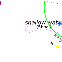
| - | + | [[Pakoštane]] is approached either from the NW along the channel separating the mainland from the islands of [[Ugljan]] and [[Pašman]] or from the S around the southern end of the island of Pašman. There are no dangers in the approach from the NW other than the numerous islands in the '''Pasmanski Kanal'''. | |
| - | + | In the approach from the S there are numerous rocky islets, some with shoals off them, and careful pilotage is needed. On closer approach, the three islets just off the town are conspicuous. The largest, central one has a cross on the top. | |
| - | + | ||
| - | == | + | ==Berthing== |
| - | The | + | The small port is too shallow for most sailboats. |
===Marinas & Yacht Clubs=== | ===Marinas & Yacht Clubs=== | ||
| - | |||
| - | |||
| - | |||
| - | |||
| - | |||
| - | |||
| - | |||
| - | |||
None. | None. | ||
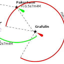
| - | == | + | ==Anchorages== |
| - | + | The best anchorages are either side of Veli Skolj, the central island. | |
| - | + | ||
| - | + | ||
| - | + | ||
| - | + | ||
| - | The | + | |
| - | + | ||
| - | + | ||
| - | + | ||
| - | ==== | + | {{poi | lat= 43.90377|lon=15.50201 |
| - | + | | type= anchorage | |
| + | | name=Veli Skolj NNW | ||
| + | | altname= | ||
| + | | url = | ||
| + | | zoom= 16 | ||
| + | | image= | ||
| + | | imagetext= | ||
| + | | text= Anchor NNW of the island in 5.0 - 6.0 metres. Good holding in sand. Shelter here is only moderate in northerly winds and poor in winds from the NW round to the SE. With strong winds from the latter direction, the anchorage is untenable. | ||
| + | }} | ||
| - | ==== | + | {{poi | lat= 43.90239|lon=15.50476 |
| + | | type= anchorage | ||
| + | | name=Veli Skolj E | ||
| + | | altname= | ||
| + | | url = | ||
| + | | zoom= 16 | ||
| + | | image= | ||
| + | | imagetext= | ||
| + | | text= Alternatively, a shallow draft yacht can anchor east of the central island in 2.5 - 3.0 metres, also in sand. | ||
| + | }} | ||
| + | |||
| + | ==Amenities== | ||
None. | None. | ||
| - | ==== | + | ==Provisioning== |
| - | + | {{mark | type= provisions |name= Pakoštane Town | lat=43.90702|lon=15.5064|zoom=17 |text= some provisions shops in the town.}} | |
| - | + | ||
| - | == | + | |
| - | + | ||
| - | ==== | + | ==Eating out== |
| - | + | {{mark | type= eatingout |name= Pakoštane Town | lat=43.90702|lon=15.5064|zoom=17 |text= several bars and restaurants in the old town.}} | |
| - | + | ==Transportation== | |
* Buses to [[Zadar]], Sibenik and local destinations. | * Buses to [[Zadar]], Sibenik and local destinations. | ||
| - | |||
* International airport of [[Zadar]] 25 kms NNE. | * International airport of [[Zadar]] 25 kms NNE. | ||
| - | * Ferries from [[Biograd]] to [[Ancona]] in Italy. | + | * Ferries from [[Biograd na Moru]] to [[Ancona]] in Italy. |
| - | == | + | ==Tourism== |
| - | + | ====History==== | |
| + | {{Green|Give a short history of the port.}} | ||
| - | == | + | ====Places to Visit==== |
| + | {{Image right|VranskoLake.jpg |Lake Vransko is rich in birdlife }} | ||
| + | The town has a beautiful situation between the seas and the lovely lake Vransko, the largest lake in Croatia. The lake is a popular nature reserve and a paradise for birdwatchers and anglers. | ||
| + | |||
| + | ==Friends== | ||
Contact details of "Cruiser's Friends" that can be contacted for local information or assistance. | Contact details of "Cruiser's Friends" that can be contacted for local information or assistance. | ||
* | * | ||
| - | == | + | ==Forums== |
List links to discussion threads on [[Cruising Forums|partnering forums]]. (''see link for requirements'') | List links to discussion threads on [[Cruising Forums|partnering forums]]. (''see link for requirements'') | ||
* | * | ||
* | * | ||
| - | == | + | ==Links== |
| - | * {{wikipedia | + | * {{wikipedia}} |
| - | * [http://vransko-jezero.hr/ | + | * [http://www.pp-vransko-jezero.hr/en/ Vransko Lake website] |
* | * | ||
| - | ''For other useful websites, see [[Croatia# | + | ''For other useful websites, see [[Croatia#Links|Croatia]]''. |
| - | ==References | + | ==References== |
| - | ''See [[Croatia# | + | ''See [[Croatia#References|Croatia]]''. |
| - | + | {{Comments}} | |
| - | + | * | |
* | * | ||
| - | + | {{Verified by}} | |
| - | + | ||
* Data compiled from web research (please update if possible) --[[User:Atheneoflymington|Athene of Lymington]] 15:22, 30 July 2011 (BST) | * Data compiled from web research (please update if possible) --[[User:Atheneoflymington|Athene of Lymington]] 15:22, 30 July 2011 (BST) | ||
* | * | ||
| + | |||
| + | |||
| + | {{Green|If you provide a lot of info and this page is almost complete, change <nowiki>{{Page outline}} to {{Page useable}}</nowiki>.}} | ||
Latest revision as of 21:10, 25 March 2019
| Pakoštane
| |
| |
 Pakoštane bay from NW |
The town of Pakoštane lies on the Adriatic coast of Croatia, around four miles SE of Biograd and opposite the SE end of the island of Pašman. Barely a mile behind the town is the huge Vransko jezero (Lake Vrana), a nature reserve.
The town has a small harbour, which is unsuitable for yachts, but a couple of lovely anchorages between the three islets lying off the town. The anchorages are only suitable for use in settled weather and untenable in strong winds with anything west or south in them.
Charts
See Northern Dalmatia.
Weather
See Croatia.
Passages
See Croatia.
Islands
Communication
Add here VHF channel for the coastguard, harbor masters. etc.
Also see Cruiser's Nets
Pakoštane is approached either from the NW along the channel separating the mainland from the islands of Ugljan and Pašman or from the S around the southern end of the island of Pašman. There are no dangers in the approach from the NW other than the numerous islands in the Pasmanski Kanal.
In the approach from the S there are numerous rocky islets, some with shoals off them, and careful pilotage is needed. On closer approach, the three islets just off the town are conspicuous. The largest, central one has a cross on the top.
Berthing
The small port is too shallow for most sailboats.
Marinas & Yacht Clubs
None.
Anchorages
The best anchorages are either side of Veli Skolj, the central island.
Veli Skolj NNW
Veli Skolj E
Amenities
None.
Provisioning
![]() Pakoštane Town [[Pakoštane#Pakoštane Town|Pakoštane Town]] 43°54.421'N, 015°30.384'E some provisions shops in the town.
Pakoštane Town [[Pakoštane#Pakoštane Town|Pakoštane Town]] 43°54.421'N, 015°30.384'E some provisions shops in the town.
Eating out
![]() Pakoštane Town [[Pakoštane#Pakoštane Town|Pakoštane Town]] 43°54.421'N, 015°30.384'E several bars and restaurants in the old town.
Pakoštane Town [[Pakoštane#Pakoštane Town|Pakoštane Town]] 43°54.421'N, 015°30.384'E several bars and restaurants in the old town.
Transportation
- Buses to Zadar, Sibenik and local destinations.
- International airport of Zadar 25 kms NNE.
- Ferries from Biograd na Moru to Ancona in Italy.
Tourism
History
Give a short history of the port.
Places to Visit

The town has a beautiful situation between the seas and the lovely lake Vransko, the largest lake in Croatia. The lake is a popular nature reserve and a paradise for birdwatchers and anglers.
Friends
Contact details of "Cruiser's Friends" that can be contacted for local information or assistance.
Forums
List links to discussion threads on partnering forums. (see link for requirements)
Links
- Pakoštane at the Wikipedia
- Vransko Lake website
For other useful websites, see Croatia.
References
See Croatia.
Comments
We welcome users' contributions to the Wiki. Please click on Comments to view other users' comments, add your own personal experiences or recommend any changes to this page following your visit.
Verified by
Date of member's last visit to Pakoštane and this page's details validated:
- Data compiled from web research (please update if possible) --Athene of Lymington 15:22, 30 July 2011 (BST)
If you provide a lot of info and this page is almost complete, change {{Page outline}} to {{Page useable}}.
| This page has an outline in place but needs completing. Please contribute if you can to help it grow further. Click on Comments to suggest further content or alternatively, if you feel confident to edit this page, click on the edit tab at the top and enter your changes directly. |
| |
|---|
|
Names: Athene of Lymington, Lighthouse |