Amasra
From CruisersWiki
m (bot: Forums) |
Istioploos (Talk | contribs) (Headers) |
||
| Line 25: | Line 25: | ||
: 121 Amasra-Inebulu | : 121 Amasra-Inebulu | ||
: 1131 Amasra | : 1131 Amasra | ||
| - | |||
| - | |||
| - | |||
| - | |||
| - | |||
| - | |||
==Weather== | ==Weather== | ||
| Line 44: | Line 38: | ||
==Navigation== | ==Navigation== | ||
The approaches to Amasra are straightforward. | The approaches to Amasra are straightforward. | ||
| + | |||
| + | ==Communication== | ||
| + | * | ||
| + | * | ||
| + | |||
| + | ''Also see [[World MM Nets|World Cruiser's Nets]]''. | ||
==Berthing== | ==Berthing== | ||
| - | + | {{Poi |41|44.75|N|32|23.59|E| | type= harbour | name= Amasra Harbor | zoom= 16 | |
| - | {{ | + | |
| - | | name= Amasra Harbor | + | |
| - | | zoom= 16 | + | |
| image= Turkey_Amasra_3.jpg | | image= Turkey_Amasra_3.jpg | ||
| imagetext= The Beach and the Harbor | | imagetext= The Beach and the Harbor | ||
| - | + | | imagewidth= | |
| - | The harbor of Amasra is large. It is better to anchor off-shore inside the harbor rather then to dock near the fishing boats that usually have an unpleasant odor. Also, the area where one can dock has strong illumination and it would not be too comfortable at night. | + | | portofentry= |
| + | | text= The harbor of Amasra is large. It is better to anchor off-shore inside the harbor rather then to dock near the fishing boats that usually have an unpleasant odor. Also, the area where one can dock has strong illumination and it would not be too comfortable at night. | ||
Anchor in 6 m with plenty of scope. The harbour is reasonably well protected from swell though at times there can be an annoying rolling due to some swell entering. The water in the harbor is murky, and there can be fierce gusts from the south. The bottom is covered with weed and the holding is not always very good and you may have to try several times. | Anchor in 6 m with plenty of scope. The harbour is reasonably well protected from swell though at times there can be an annoying rolling due to some swell entering. The water in the harbor is murky, and there can be fierce gusts from the south. The bottom is covered with weed and the holding is not always very good and you may have to try several times. | ||
| - | {{Warning}} There can be unmarked nets which can foul the anchor. | + | {{Warning}} There can be unmarked nets which can foul the anchor. }} |
===Marinas & Yacht Clubs=== | ===Marinas & Yacht Clubs=== | ||
| Line 64: | Line 62: | ||
===Anchorages=== | ===Anchorages=== | ||
{{Poi |41|50|N|32|40.3|E| | type= anchorage| name= Ovakoy | {{Poi |41|50|N|32|40.3|E| | type= anchorage| name= Ovakoy | ||
| - | | text= Ovaköy or Ovatekkeönü, just a few miles east of Amasra is the home of a traditional wooden boat shipwright Hüseyn Çoban. Unfortunately the cove is too small and too shallow for most sailboats. | + | | text= Ovaköy or Ovatekkeönü, just a few miles east of Amasra is the home of a traditional wooden boat shipwright Hüseyn Çoban. Unfortunately the cove is too small and too shallow for most sailboats.}} |
| - | + | {{hgallery2|Approaching to Ovaköy| | |
| - | + | {{himage|Turkey_Ovakoy_1.jpg}} | |
| - | + | {{himage|Turkey_Ovakoy_2.jpg}} | |
| - | + | }} | |
| - | + | {{Poi |41|51.59|N|32|51.58|E| type= anchorage | name= Sutluce | zoom= 16 | |
| - | {{ | + | |
| - | | name= | + | |
| - | + | ||
| - | + | ||
| - | + | ||
| - | + | ||
| - | | zoom= 16 | + | |
| image= Turkey_Gideros_2.jpg | | image= Turkey_Gideros_2.jpg | ||
| imagetext= Entrance to Sütlüce | | imagetext= Entrance to Sütlüce | ||
| - | + | | imagewidth= | |
| - | Sütlüce or Gideros is a jewel of a small cove surrounded by tall peaks covered with cloud about 20 nM E of [[#Amasra_Harbor|Amasra]]. Here is where the modern [http://en.wikipedia.org/wiki/Argonauts Argonauts], described by Tim Severin in the [http://www.amazon.com/exec/obidos/ISBN=0091618800 Jason Voyage], were holed-in by a gale. Alas the water is an opaque green color, covered with an oil slick, and garbage. | + | | portofentry= |
| + | | text= Sütlüce or Gideros is a jewel of a small cove surrounded by tall peaks covered with cloud about 20 nM E of [[#Amasra_Harbor|Amasra]]. Here is where the modern [http://en.wikipedia.org/wiki/Argonauts Argonauts], described by Tim Severin in the [http://www.amazon.com/exec/obidos/ISBN=0091618800 Jason Voyage], were holed-in by a gale. Alas the water is an opaque green color, covered with an oil slick, and garbage. | ||
| - | Anchoring here presents no problems. | + | Anchoring here presents no problems. }} |
==Yacht Repairs and Services== | ==Yacht Repairs and Services== | ||
| Line 141: | Line 133: | ||
==Links== | ==Links== | ||
| - | * | + | * {{wikipedia}} |
| - | * | + | * {{Wikivoyage}} |
* | * | ||
| Line 149: | Line 141: | ||
{{Comments}} | {{Comments}} | ||
| - | |||
* | * | ||
{{Verified by}} | {{Verified by}} | ||
| - | |||
* August 1999 {{Istioploos2}} | * August 1999 {{Istioploos2}} | ||
* | * | ||
Revision as of 22:49, 22 May 2016
| Amasra
| |
Amasra, the Greek Άμαστρις (Amastris) is a delightful town about 120 nM E of Sile.
Amastris was founded at the site of Sesamus which was a colony established by Milesians in the 6th century BC although Sesamus could be even earlier as it is referred to by Homer in the Iliad (Book II). According to Starbo, Amastris was founded in the 3rd century BC by queen Amastris of Heracleia Pontica (modern Eregli). She was the niece of Darius III who was defeated by Alexander the Great. She first married Craterus (a Macedonian and close friend of Alexander) and learned Greek. After Craterus died she married Dionysios the tyrant of Heracleia Pontica. Dionysios soon died also and she ruled as a Greek queen in the name of her son. Amastris was murdered by her sons in 288 BC and the city soon came under the rule of Eumenes of Tieum, brother of Philetaerus of Pergamon. Eumenes lost the city to Ariobarzanes, king of Pontus. During the Roman period, Amastris was occupied by Lucullus and became part of the Roman province of Asia. In the Byzantine era, Amastris declined. In 1214 Amastris, along with many other towns, was seized from David Komnenos by Theodore Laskaris. After the fall of the Byzantine empire Amastris was occupied by the Genoese who held the city until it was conquered by the Ottomans around 1460 AD who renamed it Amasra.
The town is rather attractive although somewhat run down.
Charts
- BA
- 2214 The Euxine or Black Sea
- 2238 Kefken Adasi to Inceburun
- 1275 Ereğli to Amasra
- NIMA
- 55100 Western Part of the Black Sea
- Turkey
- 113 Eregli-Amasra
- 121 Amasra-Inebulu
- 1131 Amasra
Weather
See Turkey.
Passages
Popular passages/routes, timing, etc.
Islands
None.
The approaches to Amasra are straightforward.
Communication
Also see World Cruiser's Nets.
Berthing
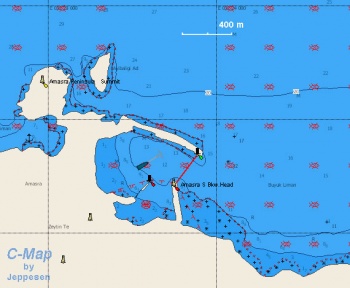
Amasra Harbor
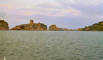
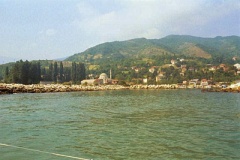
The harbor of Amasra is large. It is better to anchor off-shore inside the harbor rather then to dock near the fishing boats that usually have an unpleasant odor. Also, the area where one can dock has strong illumination and it would not be too comfortable at night.
Anchor in 6 m with plenty of scope. The harbour is reasonably well protected from swell though at times there can be an annoying rolling due to some swell entering. The water in the harbor is murky, and there can be fierce gusts from the south. The bottom is covered with weed and the holding is not always very good and you may have to try several times.
Warning: There can be unmarked nets which can foul the anchor.Marinas & Yacht Clubs
None.
Anchorages
Ovakoy
Sutluce
Sütlüce or Gideros is a jewel of a small cove surrounded by tall peaks covered with cloud about 20 nM E of Amasra. Here is where the modern Argonauts, described by Tim Severin in the Jason Voyage, were holed-in by a gale. Alas the water is an opaque green color, covered with an oil slick, and garbage.
Anchoring here presents no problems.Yacht Repairs and Services
Marine Stores
None.
Repairs/Yards
None.
Fuel, Water, & Electricity
- Fuel
- N/A (Not Available)
- Water
- N/A
- Electricity
- N/A
Things to do Ashore
Tourism
The town, while run-down, is rather attractive and has many shops and markets. It is fun to walk its streets.
Grocery & Supply Stores
- Basic shopping in the town
- Good fruits
Eateries
- Good sea food at the Çesme Cishavik which affords a good view of the harbor. Local specialties are: hamsi (a kind of sardine indigenous to the Black Sea), kalkan (a kind of ray fish), barboun (red mullet), and çoban salat (shepherd's salad very similar to Greek salad).
Internet/WiFi
Available?
Laundry
N/A.
Motorbike & Car Rentals
There is no car rentals available in Amasra. Car rentals are available in Bartin a 30 minute bus ride (see details below) from Amasra.
Garbage Disposal
Trash cans.
Transportation
Modern maroon coloured midi buses run every 30 minutes between Amasra and Bartin from 7am to late in the evening. Busses to Istanbul and other cities.
Friends
Contact details of "Cruiser's Friends" that can be contacted for local information or assistance.
Forums
List links to discussion threads on partnering forums. (see link for requirements)
Links
References & Publications
Comments
We welcome users' contributions to the Wiki. Please click on Comments to view other users' comments, add your own personal experiences or recommend any changes to this page following your visit.
Verified by
Date of member's last visit to Amasra and this page's details validated:
- August 1999 --Istioploos

 Travels with S/Y Thetis
| This is a usable page of the cruising guide. However, please contribute if you can to help it grow further. Click on Comments to add your personal notes on this page or to discuss its contents. Alternatively, if you feel confident to edit the page, click on the edit tab at the top and enter your changes directly. |
| |
|---|
|
Names: Istioploos, Rr7 |


