Angistri
From CruisersWiki
m (bot: Move Communication) |
Istioploos (Talk | contribs) (Template) |
||
| Line 4: | Line 4: | ||
| zoom= 13 | | zoom= 13 | ||
| image= Greece_Aigina_S.jpg | | image= Greece_Aigina_S.jpg | ||
| - | | imagetext= Satellite View of Aegina & Angistri | + | | imagetext= Satellite View of Aegina & Angistri |
| + | | notes= | ||
| + | | news= | ||
}} | }} | ||
| - | [http://en.wikipedia.org/wiki/Angistri Angistri] (Αγκίστρι) is a small island in the Saronic Gulf of Greece, four miles SW of the larger island of [[Aegina]]. It is a popular weekend haunt for yachts and motor boats from the marinas around Athens as well as a useful stopping off point for vessels bound to or from the Corinth Canal. The island has two small harbours, Angistri yacht harbour on the NW side and Skala on the E side. The latter is a ferry harbour and is unsuitable for yachts. At the SW end of the island, opposite the islet of Dhorousa, is a series of small, attractive anchorages giving good shelter from the prevailing N/NE winds, two of which have tavernas ashore. | + | [http://en.wikipedia.org/wiki/Angistri Angistri] (Αγκίστρι) is a small island in the Saronic Gulf of Greece, four miles SW of the larger island of [[Aegina]]. It is a popular weekend haunt for yachts and motor boats from the marinas around Athens as well as a useful stopping off point for vessels bound to or from the [[Corinth Canal]]. The island has two small harbours, Angistri yacht harbour on the NW side and Skala on the E side. The latter is a ferry harbour and is unsuitable for yachts. At the SW end of the island, opposite the islet of Dhorousa, is a series of small, attractive anchorages giving good shelter from the prevailing N/NE winds, two of which have tavernas ashore. |
==Charts== | ==Charts== | ||
| Line 22: | Line 24: | ||
==Passages== | ==Passages== | ||
| - | + | {{Green|List popular passages/routes, timing, etc.}} | |
* | * | ||
==Islands== | ==Islands== | ||
| - | + | {{Poi | type= island | lat= 37.68042|lon=23.31561|zoom=15 | name= Dhorousa I. | |
| + | | image= | imagetext= | imagewidth= | ||
| + | | text= A small island on SW side of [[Angistri]]. There is an [[#Dhorousa|anchorage]] between the island and Angistri.}} | ||
==Communication== | ==Communication== | ||
| Line 34: | Line 38: | ||
''Also see [[World MM Nets|World Cruiser's Nets]]'' | ''Also see [[World MM Nets|World Cruiser's Nets]]'' | ||
| - | |||
==Navigation== | ==Navigation== | ||
The approach to Angistri Yacht Harbour from E should be made either through the Steno Metopis, the channel between Aegina and the islets of Nisis Metopi, or around the N side of [[Aegina]] itself. The channel between Angistri and Nisis Metopi is shallow and dangerous with even moderate winds. From S and W, the approach is straightforward, except that a yacht should not approach the coast immediately W of the yacht harbour too closely as there are shoals extending 100 metres off it. | The approach to Angistri Yacht Harbour from E should be made either through the Steno Metopis, the channel between Aegina and the islets of Nisis Metopi, or around the N side of [[Aegina]] itself. The channel between Angistri and Nisis Metopi is shallow and dangerous with even moderate winds. From S and W, the approach is straightforward, except that a yacht should not approach the coast immediately W of the yacht harbour too closely as there are shoals extending 100 metres off it. | ||
| + | {{hold vertical}} | ||
==Berthing== | ==Berthing== | ||
===Ports=== | ===Ports=== | ||
| Line 43: | Line 47: | ||
| image= Greece_Angistri_h.jpg | | image= Greece_Angistri_h.jpg | ||
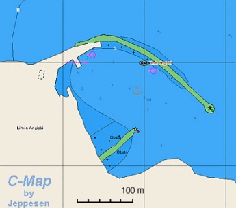
| imagetext= Chart of Angistri harbour | | imagetext= Chart of Angistri harbour | ||
| - | | imagewidth | + | | imagewidth= |
| - | + | ||
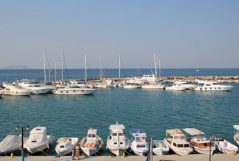
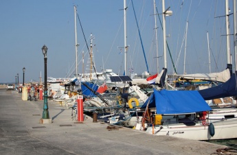
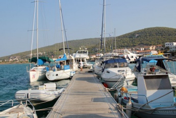
| text= The harbour lies immediately NW of the only settlement on the island and it is the only place on the island which offers good shelter in all conditions (with the exception of strong E or NE winds, which send a swell into the harbour). The harbour consists of a long curved breakwater extending N and E from the shore and a short jetty extending N from the shore just inside the entrance. The harbour is entered from ESE around the end of the breakwater. Depths shoal in the approach to the entrance to 4.0 – 5.0 metres, but the water is so clear here you can see the bottom. Depths in the harbour are 2.5 – 4.5 metres. Much of the harbour is taken up with permanent moorings and visiting yachts will normally have two options: mooring stern/bows-to the breakwater quay, where depths range from 2.5 metres at the inner corner to 4.5 metres at the outer end; or mooring alongside on either side of a short pontoon that extends at right angles from the breakwater quay. Depths along the pontoon are 3.5 – 4.0 metres. If mooring on the quay, you will probably need to use your anchor. Be sure to lay out at least 25 metres or so to avoid the mooring blocks of the boats on laid moorings. Because the quay curves round the harbour, crossed anchors are common, especially at busy periods when vessels are sometimes double-banked. If arriving late and the harbour is full, it may also be possible to lie alongside the short jetty at the entrance once the ferries have stopped running. Water and electricity are available along the quay but not on the pontoon. Water is restricted and you will have to ask for it to be turned on.}} | | text= The harbour lies immediately NW of the only settlement on the island and it is the only place on the island which offers good shelter in all conditions (with the exception of strong E or NE winds, which send a swell into the harbour). The harbour consists of a long curved breakwater extending N and E from the shore and a short jetty extending N from the shore just inside the entrance. The harbour is entered from ESE around the end of the breakwater. Depths shoal in the approach to the entrance to 4.0 – 5.0 metres, but the water is so clear here you can see the bottom. Depths in the harbour are 2.5 – 4.5 metres. Much of the harbour is taken up with permanent moorings and visiting yachts will normally have two options: mooring stern/bows-to the breakwater quay, where depths range from 2.5 metres at the inner corner to 4.5 metres at the outer end; or mooring alongside on either side of a short pontoon that extends at right angles from the breakwater quay. Depths along the pontoon are 3.5 – 4.0 metres. If mooring on the quay, you will probably need to use your anchor. Be sure to lay out at least 25 metres or so to avoid the mooring blocks of the boats on laid moorings. Because the quay curves round the harbour, crossed anchors are common, especially at busy periods when vessels are sometimes double-banked. If arriving late and the harbour is full, it may also be possible to lie alongside the short jetty at the entrance once the ferries have stopped running. Water and electricity are available along the quay but not on the pontoon. Water is restricted and you will have to ask for it to be turned on.}} | ||
| Line 54: | Line 57: | ||
None. | None. | ||
| - | == | + | ===Anchorages=== |
| - | ==== | + | {{Poi | type= anchorage | lat= 37.6809|lon=23.32028|zoom=16 | name= Dhorousa |
| - | + | | image= | imagetext= | imagewidth= | |
| - | ==== | + | | text= Looks attractive. Tavernas ashore. }} |
| - | + | ||
| - | ==== | + | ==Facilities== |
| - | + | ====Water==== | |
| - | + | {{mark |name= [[#Angistri Yacht Harbour|Angistri Yacht Harbour|]] |type= water | |text= On the quay but supplies are restricted and you will have go ask for it to be turned on.}} | |
| - | + | ||
| - | + | ||
| - | + | ||
| - | + | ||
| - | == | + | ====Electricity==== |
| - | ==== | + | {{mark |name= [[#Angistri Yacht Harbour|Angistri Yacht Harbour|]] |type= electricity | |text= On the quay.}} |
| - | + | ||
| - | ==== | + | ====Toilets==== |
| - | + | N/A (Not Available). | |
| - | ==== | + | ====Showers==== |
| - | + | N/A. | |
| - | + | ||
| - | + | ||
| - | + | ||
| - | + | ||
====Laundry==== | ====Laundry==== | ||
| - | + | N/A. | |
| - | + | ====Garbage==== | |
| - | + | ||
| - | + | ||
| - | ====Garbage | + | |
There are bins around the harbour. | There are bins around the harbour. | ||
| - | ==== | + | ==Supplies== |
| + | |||
| + | ====Fuel==== | ||
| + | {{mark |name= [[#Angistri Yacht Harbour|Angistri Yacht Harbour|]] | type= fuel | |text= Available by tanker on the quay.}} | ||
| + | |||
| + | ====Cooking gas==== | ||
| + | {{Green|Give details on cooking gas (''Camping Gaz'', butane, propane, etc) suppliers. If there are no suppliers in the island just enter "None".}} | ||
| + | |||
| + | {{mark |name= {{Magenta|Suplier1}}| type= cooking | lat= {{Magenta|DD.ddd}} | lon= {{Magenta|DD.ddd}} |text= {{Magenta| gas supplier location etc, tel. +XX XXXX XXXXX}}.}} | ||
| + | |||
| + | ====Chandlers==== | ||
| + | None. | ||
| + | |||
| + | ==Services== | ||
| + | ====Repairs==== | ||
| + | N/A. | ||
| + | |||
| + | ====Internet==== | ||
| + | In internet cafés. | ||
| + | |||
| + | ====Mobile connectivity==== | ||
| + | Good 3G signal. | ||
| + | |||
| + | ====Vehicle Rentals==== | ||
| + | {{mark |name= [[#Angistri Yacht Harbour|Angistri Yacht Harbour|]] | type= car | |text= Near the harbour.}} | ||
| + | |||
| + | ==Provisioning== | ||
| + | {{mark |name= [[#Angistri Yacht Harbour|Angistri Yacht Harbour|]] | type= provisions | |text= Basic groceries only.}} | ||
| + | |||
| + | ==Transportation== | ||
There are daily ferries and a fast hydrofoil to Aegina and the mainland. | There are daily ferries and a fast hydrofoil to Aegina and the mainland. | ||
| + | |||
| + | ==Eating out== | ||
| + | * [[#Angistri Yacht Harbour|Angistri Yacht Harbour|]] | ||
| + | : {{mark |name= '' ''| type= eatingout | text= Several tavernas and cafes around the yacht harbour.}} | ||
| + | * [[#Dhorousa|Dhorousa]] | ||
| + | : {{mark |name= '' ''| type= eatingout | text= Simple tavernas.}} | ||
| + | |||
| + | ==Tourism== | ||
| + | ====Places to Visit==== | ||
| + | The island is wooded and pleasant to walk around and there is good snorkelling off the coast, but there is not a lot to do otherwise. | ||
==Friends== | ==Friends== | ||
Revision as of 08:41, 7 September 2016
| Angistri
| |
Angistri (Αγκίστρι) is a small island in the Saronic Gulf of Greece, four miles SW of the larger island of Aegina. It is a popular weekend haunt for yachts and motor boats from the marinas around Athens as well as a useful stopping off point for vessels bound to or from the Corinth Canal. The island has two small harbours, Angistri yacht harbour on the NW side and Skala on the E side. The latter is a ferry harbour and is unsuitable for yachts. At the SW end of the island, opposite the islet of Dhorousa, is a series of small, attractive anchorages giving good shelter from the prevailing N/NE winds, two of which have tavernas ashore.
Charts
- BA
- 1657 Saronikós Kólpos
- Imray-Tetra
- G14 Saronic and Argolic Gulf
- NIMA
- 54344 Saronicos Kolpos & K. Petalion
- Greek
- 413 Saronikos Kolpos
Weather
See Aegean Sea.
Passages
List popular passages/routes, timing, etc.
Islands
Dhorousa I.
Communication
- Coast Guard - VHF 12
- Weather - VHF channel 86
Also see World Cruiser's Nets
The approach to Angistri Yacht Harbour from E should be made either through the Steno Metopis, the channel between Aegina and the islets of Nisis Metopi, or around the N side of Aegina itself. The channel between Angistri and Nisis Metopi is shallow and dangerous with even moderate winds. From S and W, the approach is straightforward, except that a yacht should not approach the coast immediately W of the yacht harbour too closely as there are shoals extending 100 metres off it.
Berthing
Ports
Angistri Yacht Harbour
Marinas & Yacht Clubs
None.
Anchorages
Dhorousa
Facilities
Water
![]() Angistri Yacht Harbour| [[Angistri#Angistri Yacht Harbour||Angistri Yacht Harbour|]] On the quay but supplies are restricted and you will have go ask for it to be turned on.
Angistri Yacht Harbour| [[Angistri#Angistri Yacht Harbour||Angistri Yacht Harbour|]] On the quay but supplies are restricted and you will have go ask for it to be turned on.
Electricity
![]() Angistri Yacht Harbour| [[Angistri#Angistri Yacht Harbour||Angistri Yacht Harbour|]] On the quay.
Angistri Yacht Harbour| [[Angistri#Angistri Yacht Harbour||Angistri Yacht Harbour|]] On the quay.
Toilets
N/A (Not Available).
Showers
N/A.
Laundry
N/A.
Garbage
There are bins around the harbour.
Supplies
Fuel
![]() Angistri Yacht Harbour| [[Angistri#Angistri Yacht Harbour||Angistri Yacht Harbour|]] Available by tanker on the quay.
Angistri Yacht Harbour| [[Angistri#Angistri Yacht Harbour||Angistri Yacht Harbour|]] Available by tanker on the quay.
Cooking gas
Give details on cooking gas (Camping Gaz, butane, propane, etc) suppliers. If there are no suppliers in the island just enter "None".
![]() Suplier1 [[Angistri#Suplier1|Suplier1]]
Suplier1 [[Angistri#Suplier1|Suplier1]]
Chandlers
None.
Services
Repairs
N/A.
Internet
In internet cafés.
Mobile connectivity
Good 3G signal.
Vehicle Rentals
![]() Angistri Yacht Harbour| [[Angistri#Angistri Yacht Harbour||Angistri Yacht Harbour|]] Near the harbour.
Angistri Yacht Harbour| [[Angistri#Angistri Yacht Harbour||Angistri Yacht Harbour|]] Near the harbour.
Provisioning
![]() Angistri Yacht Harbour| [[Angistri#Angistri Yacht Harbour||Angistri Yacht Harbour|]] Basic groceries only.
Angistri Yacht Harbour| [[Angistri#Angistri Yacht Harbour||Angistri Yacht Harbour|]] Basic groceries only.
Transportation
There are daily ferries and a fast hydrofoil to Aegina and the mainland.
Eating out
- Please specify POI name
 [[Angistri# | ]] Several tavernas and cafes around the yacht harbour.
- Please specify POI name
 [[Angistri# | ]] Simple tavernas.
Tourism
Places to Visit
The island is wooded and pleasant to walk around and there is good snorkelling off the coast, but there is not a lot to do otherwise.
Friends
Contact details of "Cruiser's Friends" that can be contacted for local information or assistance.
Forums
List links to discussion threads on partnering forums. (see link for requirements)
Links
- Angistri (Wkipedia)
References & Publications
See Greece.
Comments
We welcome users' contributions to the Wiki. Please click on Comments to view other users' comments, add your own personal experiences or recommend any changes to this page following your visit.
Verified by
Date of member's last visit to Angistri and this page's details validated:
- 1991 --Istioploos

 Travels with S/Y Thetis
- September 2011 --Athene of Lymington 14:53, 10 September 2011 (BST)
| This is a usable page of the cruising guide. However, please contribute if you can to help it grow further. Click on Comments to add your personal notes on this page or to discuss its contents. Alternatively, if you feel confident to edit the page, click on the edit tab at the top and enter your changes directly. |
| |
|---|
|
Names: Istioploos, Athene of Lymington |


