Ayia Eufimia
From CruisersWiki
| Line 13: | Line 13: | ||
| [http://mapserver.mytopo.com/homepage/index.cfm?lat=38.30385777918006&lon=20.60072059696097&scale=7500&zoom=50&type=0&icon=0&searchscope=int&CFID=18293118&CFTOKEN=13569456&scriptfile=http://mapserver.mytopo.com/homepage/index.cfm&latlontype=DMS Local chartlet] | | [http://mapserver.mytopo.com/homepage/index.cfm?lat=38.30385777918006&lon=20.60072059696097&scale=7500&zoom=50&type=0&icon=0&searchscope=int&CFID=18293118&CFTOKEN=13569456&scriptfile=http://mapserver.mytopo.com/homepage/index.cfm&latlontype=DMS Local chartlet] | ||
|- | |- | ||
| - | | colspan="2" style="text-align:center; font-size: smaller;" | [[Image: | + | | colspan="2" style="text-align:center; font-size: smaller;" | [[Image:EufimiaHarbour.jpg|350px]] Ayia Eufimia harbour from S <br />''click for larger view'' |
|}{{TOCleft}} | |}{{TOCleft}} | ||
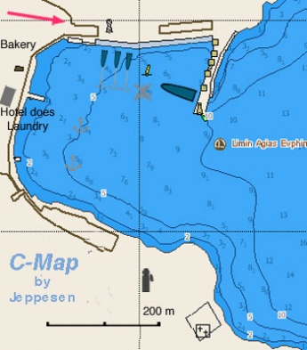
| - | [[Image:Efimia_h.jpg|thumb|345px|right|Chart of Ayia | + | [[Image:Efimia_h.jpg|thumb|345px|right|Chart of Ayia Eufimía<br />''Click for larger view]] |
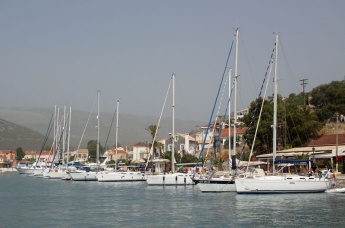
| - | + | [[Image:EufimiaMoorings.jpg|thumb|345px|right|Yachts moored in Ayia Eufimia<br />''Click for larger view]] | |
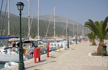
| + | [[Image:EufimiaQuay.jpg|thumb|345px|right|The quay is high at Ayia Eufimia<br />''Click for larger view]] | ||
Ayia Efimía (Αγία Ευφημεία) or Ayia Eufimia (saint well spoken of) lies on the E coast of the island of [[Kefalonia]], 10 miles S of the harbour of [[Fiskardo]]. Considerable investment has been made in refurbishing the quay here, including installing water and electricity points all the way along, and the harbour is staffed to receive visiting yachts, of which there are considerable numbers during the season, and take their lines ashore. The harbour is sometimes crowded with flotilla boats, but even when full it is also a well protected cove in which to anchor off in the harbour. Shelter here is good in most conditions, although the prevailing NW wind tends to gust down into the harbour. Strong easterly winds send in an uncomfortable swell, albeit not a dangerous one. Ashore there is an excellent bakery, several provisions stores, and restaurants. Ayia Eufimia is a good alternative to Argostoli as a base from which to tour the island. | Ayia Efimía (Αγία Ευφημεία) or Ayia Eufimia (saint well spoken of) lies on the E coast of the island of [[Kefalonia]], 10 miles S of the harbour of [[Fiskardo]]. Considerable investment has been made in refurbishing the quay here, including installing water and electricity points all the way along, and the harbour is staffed to receive visiting yachts, of which there are considerable numbers during the season, and take their lines ashore. The harbour is sometimes crowded with flotilla boats, but even when full it is also a well protected cove in which to anchor off in the harbour. Shelter here is good in most conditions, although the prevailing NW wind tends to gust down into the harbour. Strong easterly winds send in an uncomfortable swell, albeit not a dangerous one. Ashore there is an excellent bakery, several provisions stores, and restaurants. Ayia Eufimia is a good alternative to Argostoli as a base from which to tour the island. | ||
| Line 34: | Line 35: | ||
: 2 Ionio Pelagos | : 2 Ionio Pelagos | ||
: 30 Kefalonia, Ithaki | : 30 Kefalonia, Ithaki | ||
| - | |||
==Radio Nets== | ==Radio Nets== | ||
* | * | ||
| Line 41: | Line 41: | ||
==Approach and Navigation== | ==Approach and Navigation== | ||
There are no dangers in the approach. The harbour lies at the NW corner of a large bay, Sami Bay, partially protected from E by a long breakwater extending S from the shore. It is identifiable from distance by the wind turbines on the high hills behind the port. | There are no dangers in the approach. The harbour lies at the NW corner of a large bay, Sami Bay, partially protected from E by a long breakwater extending S from the shore. It is identifiable from distance by the wind turbines on the high hills behind the port. | ||
| - | |||
==Check-in facilities (for Customs and Immigration)== | ==Check-in facilities (for Customs and Immigration)== | ||
Ayia Eufimia is not a port of entry. The nearest ports of entry on the island are Argostoli or Sami. | Ayia Eufimia is not a port of entry. The nearest ports of entry on the island are Argostoli or Sami. | ||
| Line 47: | Line 46: | ||
==Berthing Options== | ==Berthing Options== | ||
The harbour staff direct visiting yachts where to berth and take their lines. Yachts anchor moor on the quay at the N side of the harbour, where there is space for some 30-40 yachts in depths of 3.0 – 4.0 metres at the quay. Anchoring depths are around 6.0 – 7.0 metres. It is wise to lay out plenty of chain here and ensure your anchor is well dug in, as the holding in sand - with a few rocks and weed patches- is uncertain in places and the winds tend to blow on the beam. Note also that the quay is very high here and although there are mooring rings in the wall many yachts will also need to take lines to the yellow-painted bollards on the quay. | The harbour staff direct visiting yachts where to berth and take their lines. Yachts anchor moor on the quay at the N side of the harbour, where there is space for some 30-40 yachts in depths of 3.0 – 4.0 metres at the quay. Anchoring depths are around 6.0 – 7.0 metres. It is wise to lay out plenty of chain here and ensure your anchor is well dug in, as the holding in sand - with a few rocks and weed patches- is uncertain in places and the winds tend to blow on the beam. Note also that the quay is very high here and although there are mooring rings in the wall many yachts will also need to take lines to the yellow-painted bollards on the quay. | ||
| - | |||
===Marinas & Yacht Clubs=== | ===Marinas & Yacht Clubs=== | ||
Revision as of 16:49, 30 May 2013
Ayia Eufimia, Kefalonia
| | |
| | 38°18.05′N, 20°36.10′E |
|---|---|
| | Photo gallery |
| | Local chartlet |
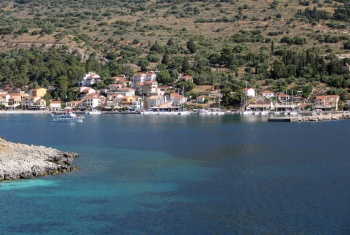 Ayia Eufimia harbour from S Ayia Eufimia harbour from S click for larger view | |
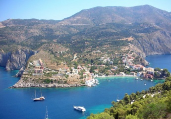
Ayia Efimía (Αγία Ευφημεία) or Ayia Eufimia (saint well spoken of) lies on the E coast of the island of Kefalonia, 10 miles S of the harbour of Fiskardo. Considerable investment has been made in refurbishing the quay here, including installing water and electricity points all the way along, and the harbour is staffed to receive visiting yachts, of which there are considerable numbers during the season, and take their lines ashore. The harbour is sometimes crowded with flotilla boats, but even when full it is also a well protected cove in which to anchor off in the harbour. Shelter here is good in most conditions, although the prevailing NW wind tends to gust down into the harbour. Strong easterly winds send in an uncomfortable swell, albeit not a dangerous one. Ashore there is an excellent bakery, several provisions stores, and restaurants. Ayia Eufimia is a good alternative to Argostoli as a base from which to tour the island.
Local Weather
- See Ionian Sea Weather.
- Also see Ionian Sea Currents & Tides.
Charts
- BA
- 203 Nisos Zakinthos to Nisos Paxoi
- 1557 Argostoli Port
- Imray-Tetra
- G12 Nísos Levkas to Nísos Zákinthos
- NIMA
- 54280 Corfu Channel to Nisis Proti
- Greek
- 2 Ionio Pelagos
- 30 Kefalonia, Ithaki
Radio Nets
Also see World Cruiser's Nets.
There are no dangers in the approach. The harbour lies at the NW corner of a large bay, Sami Bay, partially protected from E by a long breakwater extending S from the shore. It is identifiable from distance by the wind turbines on the high hills behind the port.
Check-in facilities (for Customs and Immigration)
Ayia Eufimia is not a port of entry. The nearest ports of entry on the island are Argostoli or Sami.
Berthing Options
The harbour staff direct visiting yachts where to berth and take their lines. Yachts anchor moor on the quay at the N side of the harbour, where there is space for some 30-40 yachts in depths of 3.0 – 4.0 metres at the quay. Anchoring depths are around 6.0 – 7.0 metres. It is wise to lay out plenty of chain here and ensure your anchor is well dug in, as the holding in sand - with a few rocks and weed patches- is uncertain in places and the winds tend to blow on the beam. Note also that the quay is very high here and although there are mooring rings in the wall many yachts will also need to take lines to the yellow-painted bollards on the quay.
Marinas & Yacht Clubs
None.
Anchorages
Anchor towards the S of the bay; the harbour master will direct you to a spot if asked. Drop the anchor in 4.0 - 5.0 metres. The holding is not good everywhere, so make sure that your anchor is well dug in before you leave your boat. It is best to check by snorkeling. Once the anchor holds, the place is very secure, although there is a nasty swell in strong E or SE winds.
I have been here with very strong squalls without any problems (--Istioploos 07:32, 19 April 2008 (MDT)).
Offshore Islands and Groups
Yacht Repairs and Services
None.
Marine Stores
None.
Repairs/Yards
None.
Fuel, Water, & Electricity
- Fuel
- Fuel can be delivered by road tanker
- Water
- Water on the quay
- Electricity
- Electricity on the quay
Things to do Ashore
Tourism
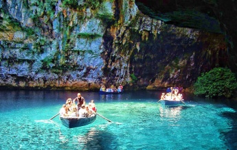
Ayia Eufimia is not as attractive a harbour as Fiskardo, having been severely damaged in the 1953 earthquake, but attracts a modest level of tourism to its shingle beach and numerous waterfront tavernas. It is also a good place to moor for a visit to the Cave of Melissani, an underground lake fed by a subterranean stream which flows all the way across the island from Argostoli. The cave is eight kms S of Ayia Eufimia along the road to Sami. It is best to visit around midday, when the sun streams down through the roof and turns the water below the colour of turquoise. Boatmen row visitors around the cave. A further five kms inland from Sami is the Drogarati Cave, a huge grotto with plentiful stalactites, so large that it is even used as an occasional concert venue. Finally, the harbour is, with transport, within easy reach of Assos some 15 kms to the NW – that is assuming you are not confident enough to take your yacht there.
Grocery & Supply Stores
- Several small supermarkets in the town
Eateries
- Numerous tavernas and cafes along the waterfont
Internet/WiFi
From several tavernas and cafes.
Laundry
A local lady will do laundry on request. Ask the harbour staff for details.
Motorbike & Car Rentals
- Car and scooter rental outlets in the town.
Garbage Disposal
Bins on the road behind the quay.
Transportation
- Local buses to Sami and Argostoli
Routes/Passages To/From
Cruiser's Friends
Contact details of "Cruiser's Friends" that can be contacted for local information or assistance.
Forum Discussions
List links to discussion threads on partnering forums. (see link for requirements)
External Links
References & Publications
See Ionian Sea.
Personal Notes
Personal experiences?
- We were on the quay here in an E going SE force 5/6 and experienced a very uncomfortable swell. Several yachts dragged. The harbour would probably be wholly untenable in much more E wind than this. It pays to berth at the E end of the quay with anything E in the forecast in order to get a partial lee from the breakwater. --Athene of Lymington 17:10, 28 May 2013 (BST)
Last Visited & Details Checked (and updated here)
Date of member's visit to this Port/Stop & this page's details validated:
- October 2004 --Istioploos

- May 2011 --Monterey

- May 2013 --Athene of Lymington 12:32, 28 May 2013 (BST)
|
|---|
|
Names: Istioploos, Athene of Lymington |
| |
|---|
| | HOMEPAGE | Wiki Contents | Mediterranean | Ionian Sea | Greece | Kefalonia | Ayia Eufimia| |
