Božava
From CruisersWiki
(→Berthing options) |
Istioploos (Talk | contribs) (Chartlet) |
||
| Line 1: | Line 1: | ||
| - | == | + | {{Infobox |44|8.35|N|14|54.441|E| |
| - | {| class="infobox bordered" style="width: | + | | mapzoom= 17 |
| + | | image= BozavaAerial.jpg | ||
| + | | imagetext= Bozava harbour from E - ''Click for larger view'' | ||
| + | }} {{TOCleft}} | ||
| + | {| class="infobox bordered" style="width: 28em; text-align: right; font-size: 90%;" | ||
|- | |- | ||
| - | + | | colspan="2" style="text-align:center;" | <googlemap lat="44.139764" lon="14.906559" zoom="17" width="352" scale="yes"></googlemap> | |
| - | + | ||
| - | + | ||
| - | + | ||
| - | + | ||
| - | + | ||
| - | + | ||
| - | + | ||
| - | + | ||
| - | + | ||
| - | + | ||
| - | + | ||
| - | | colspan="2" style="text-align:center;" | <googlemap lat="44.139764" lon="14.906559" zoom="17" width=" | + | |
|} | |} | ||
| - | |||
| - | |||
The village and harbour of Bozava are situated on the NE coast of the island of [[Dugi Otok]] ten miles W of the mainland coast of [[Croatia]] and facing the island of Sestrunj. The surroundings of the village are leafy and attractive and Bozava is consequently a popular port of call for yachts cruising the area and sustains a fair amount of local tourism at its two sizeable hotels. Shelter in the harbour is good in all conditions except strong SE winds. | The village and harbour of Bozava are situated on the NE coast of the island of [[Dugi Otok]] ten miles W of the mainland coast of [[Croatia]] and facing the island of Sestrunj. The surroundings of the village are leafy and attractive and Bozava is consequently a popular port of call for yachts cruising the area and sustains a fair amount of local tourism at its two sizeable hotels. Shelter in the harbour is good in all conditions except strong SE winds. | ||
| - | + | ==Local Weather== | |
| - | + | Diurnal winds among the islands are mostly moderate during the summer months, predominantly from NW and rarely exceeding force 4/5, although gusting is common in narrow channels between islands and on the lee side of headlands. At night, katabatic winds off the mountains affect some of the islands close to the mainland coast. During early spring and (especially) autumn conditions can be more unsettled, occasionally accompanied by violent thunderstorms - luckily of short duration - with winds of 30-35 knots or more and vicious, steep seas. In the winter the sudden, violent N wind off the mountains, the ''bora'', is much to be feared, especially along the coast from Rijeka down to Zadar, although its effects can be felt as far south as Split. | |
| - | [[ | + | |
| + | Equally prevalent in winter - although not uncommon in summer - is the ''scirocco'', a S/SE wind that blows up from North Africa, usually in advance of a depression moving E across the Mediterranean. Unlike the ''bora'', the ''scirocco'' only occasionally exceeds gale force, but is still a phenomenon to be wary of, especially if on a lee coast. | ||
| + | |||
| + | ''For sources of weather forecasting, see [[Croatia#Sources of weather forecast info|Croatia]]''. | ||
| + | {{hold horizontal}} | ||
==Charts== | ==Charts== | ||
| Line 33: | Line 27: | ||
: M25 (Otok Rab to Sibenik) | : M25 (Otok Rab to Sibenik) | ||
| - | == | + | ==Radio Nets== |
| - | + | * | |
| + | * | ||
| - | + | ''Also see [[World MM Nets|World Cruiser's Nets]]''. | |
| - | + | ||
| - | + | ||
==Approach and Navigation== | ==Approach and Navigation== | ||
| Line 46: | Line 39: | ||
Bozava is a seasonal port of entry. The nearest year-round port of entry is [[Zadar]]. | Bozava is a seasonal port of entry. The nearest year-round port of entry is [[Zadar]]. | ||
| - | ==Berthing | + | ==Berthing Options== |
| + | {{Image right|BozavaHarbour.jpg |Yachts moored on Bozava quays - ''Click for larger view'' }} | ||
There are three mooring options for visiting yachts: | There are three mooring options for visiting yachts: | ||
| - | ''' | + | # '''Breakwater quay''' |
| - | + | #: The inside of the breakwater is quayed along its whole length. There are laid moorings here for around 8 yachts in depths ranging from 2.0 metres at the root to 8.0 metres at the end. These moorings provide good shelter in winds from all directions except E round to SE. There are water and electricity points on the quay. Cost for 15m was 420Kn in May 2014 including electricity and water. | |
| + | # '''North quay''' | ||
| + | #: There are a further 12-15 moorings laid along the quay on the N side of the harbour, at right angles to the breakwater. Depths are shallower here, mostly around 2.0 metres or less, and it is advisable for all but shallow draft yachts to go bows-to. Again, shelter is good in winds from all directions except E round to SE. There are water and electricity points along this quay also. | ||
| + | # '''Outside quay''' | ||
| + | #: There is a short quay outside the harbour on the N side of the inlet, just outside the breakwater, where around six yachts can moor, using the laid lines provided. Depths here are 5.0 - 6.0 metres, making these berths suitable for deeper draft yachts. Shelter is adequate here in all except E and SE winds, though there is slightly more swell in any wind conditions than inside the harbour. There are water and electricity points on the quay. | ||
| - | + | ===Marinas & Yacht Clubs=== | |
| + | None. | ||
| - | + | ===Anchorages=== | |
| - | + | It is possible to anchor if the harbour is full on the N side of the inlet in 12-15 metres. In view of the depths here, it is sensible to take lines ashore. Holding is good in sand and weed. Shelter is adequate in settled conditions. | |
| - | + | ||
| - | + | ||
| - | + | ||
| - | + | ||
| - | + | ||
| - | + | ||
| - | + | ||
==Offshore Islands and Groups== | ==Offshore Islands and Groups== | ||
| Line 68: | Line 60: | ||
* [[Iz]] | * [[Iz]] | ||
* [[Molat]] | * [[Molat]] | ||
| - | |||
| - | |||
| - | |||
| - | |||
| - | |||
| - | |||
==Yacht Repairs and Services== | ==Yacht Repairs and Services== | ||
| Line 83: | Line 69: | ||
==Things to do Ashore== | ==Things to do Ashore== | ||
====Tourism==== | ====Tourism==== | ||
| + | {{Image right|BozavaVillage.jpg |Bozava village - ''Click for larger view'' }} | ||
| + | |||
Bozava is arguably the most developed tourist town on Dugi Otok, with two sizeable hotel complexes and a thriving dive centre. The area around is covered with pine forest and there are numerous walking trails that are worth exploring. The church of St. Nicholas in the village houses three Gothic processional crosses dating back to the 14th and 15th centuries. | Bozava is arguably the most developed tourist town on Dugi Otok, with two sizeable hotel complexes and a thriving dive centre. The area around is covered with pine forest and there are numerous walking trails that are worth exploring. The church of St. Nicholas in the village houses three Gothic processional crosses dating back to the 14th and 15th centuries. | ||
| Line 108: | Line 96: | ||
* Seasonal ferries to [[Ancona]] in Italy. | * Seasonal ferries to [[Ancona]] in Italy. | ||
* Local buses to Zaglav and Sali. | * Local buses to Zaglav and Sali. | ||
| + | |||
| + | ==Routes/Passages To/From== | ||
| + | ''See [[Croatia#Popular_Routes.2FCruises|Croatia]]''. | ||
==Cruiser's Friends== | ==Cruiser's Friends== | ||
Contact details of "Cruiser's Friends" that can be contacted for local information or assistance. | Contact details of "Cruiser's Friends" that can be contacted for local information or assistance. | ||
* | * | ||
| + | |||
==Forum Discussions== | ==Forum Discussions== | ||
| - | List links to discussion threads on [[Cruising Forums|partnering forums]]. (see link for requirements) | + | List links to discussion threads on [[Cruising Forums|partnering forums]]. (''see link for requirements'') |
| - | * | + | * |
| + | |||
==External Links== | ==External Links== | ||
| - | See [[Croatia]]. | + | ''See [[Croatia#External Links| Croatia]]''. |
==References & Publications== | ==References & Publications== | ||
| Line 125: | Line 118: | ||
* | * | ||
| - | ====Last Visited & Details Checked (and updated here) | + | ====Last Visited & Details Checked (and updated here)==== |
''Date of member's visit to this Port/Stop & this page's details validated'': | ''Date of member's visit to this Port/Stop & this page's details validated'': | ||
* August 2005 --[[User:Atheneoflymington|Athene of Lymington]] 17:27, 23 April 2012 (BST) | * August 2005 --[[User:Atheneoflymington|Athene of Lymington]] 17:27, 23 April 2012 (BST) | ||
| + | * | ||
| - | {{ | + | {{Page useable}} |
| - | + | {{Contributors|[[User:Atheneoflymington|Athene of Lymington]]}} | |
| - | { | + | |
| - | + | ||
| - | | | + | |
| - | + | ||
| - | + | ||
| - | + | ||
| - | + | ||
| - | + | {{Navbar| [[Mediterranean]] | [[Adriatic Sea]] | [[Croatia]] | [[Kornati Islands]] | [[Dugi Otok]] | [[Bozava]] }} | |
| - | { | + | |
| - | + | ||
| - | + | ||
| - | + | ||
| - | + | ||
[[Category:Ports - Croatia]] [[Category:Anchorages - Croatia]] | [[Category:Ports - Croatia]] [[Category:Anchorages - Croatia]] | ||
Revision as of 15:33, 15 June 2015
| Božava
| |
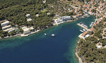
The village and harbour of Bozava are situated on the NE coast of the island of Dugi Otok ten miles W of the mainland coast of Croatia and facing the island of Sestrunj. The surroundings of the village are leafy and attractive and Bozava is consequently a popular port of call for yachts cruising the area and sustains a fair amount of local tourism at its two sizeable hotels. Shelter in the harbour is good in all conditions except strong SE winds.
Local Weather
Diurnal winds among the islands are mostly moderate during the summer months, predominantly from NW and rarely exceeding force 4/5, although gusting is common in narrow channels between islands and on the lee side of headlands. At night, katabatic winds off the mountains affect some of the islands close to the mainland coast. During early spring and (especially) autumn conditions can be more unsettled, occasionally accompanied by violent thunderstorms - luckily of short duration - with winds of 30-35 knots or more and vicious, steep seas. In the winter the sudden, violent N wind off the mountains, the bora, is much to be feared, especially along the coast from Rijeka down to Zadar, although its effects can be felt as far south as Split.
Equally prevalent in winter - although not uncommon in summer - is the scirocco, a S/SE wind that blows up from North Africa, usually in advance of a depression moving E across the Mediterranean. Unlike the bora, the scirocco only occasionally exceeds gale force, but is still a phenomenon to be wary of, especially if on a lee coast.
For sources of weather forecasting, see Croatia.
Charts
- British Admiralty
- 515
- 2773
- Croatian charts
- MK13
- Imray
- M25 (Otok Rab to Sibenik)
Radio Nets
Also see World Cruiser's Nets.
There are no dangers in the immediate approach to Bozava. The white-painted light structure on the headland of Rt Sv Nedjelja at the N entrance to the inlet is conspicuous from some distance. Closer in, the breakwater extending SW from the N side of the harbour will be evident. Arriving from N, the large hotel on the S side of the inlet is very prominent. Depths in the approach are considerable until approaching the harbour entrance, where depths reduce to 7.0 - 8.0 metres.
Check-in facilities (for Customs and Immigration)
Bozava is a seasonal port of entry. The nearest year-round port of entry is Zadar.
Berthing Options
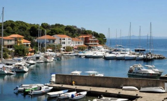
There are three mooring options for visiting yachts:
- Breakwater quay
- The inside of the breakwater is quayed along its whole length. There are laid moorings here for around 8 yachts in depths ranging from 2.0 metres at the root to 8.0 metres at the end. These moorings provide good shelter in winds from all directions except E round to SE. There are water and electricity points on the quay. Cost for 15m was 420Kn in May 2014 including electricity and water.
- North quay
- There are a further 12-15 moorings laid along the quay on the N side of the harbour, at right angles to the breakwater. Depths are shallower here, mostly around 2.0 metres or less, and it is advisable for all but shallow draft yachts to go bows-to. Again, shelter is good in winds from all directions except E round to SE. There are water and electricity points along this quay also.
- Outside quay
- There is a short quay outside the harbour on the N side of the inlet, just outside the breakwater, where around six yachts can moor, using the laid lines provided. Depths here are 5.0 - 6.0 metres, making these berths suitable for deeper draft yachts. Shelter is adequate here in all except E and SE winds, though there is slightly more swell in any wind conditions than inside the harbour. There are water and electricity points on the quay.
Marinas & Yacht Clubs
None.
Anchorages
It is possible to anchor if the harbour is full on the N side of the inlet in 12-15 metres. In view of the depths here, it is sensible to take lines ashore. Holding is good in sand and weed. Shelter is adequate in settled conditions.
Offshore Islands and Groups
Yacht Repairs and Services
None.
Fuel, Water, & Electricity
Nearest fuel in U. Triluke. Water and electricity on the quays.
Things to do Ashore
Tourism
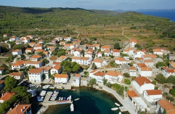
Bozava is arguably the most developed tourist town on Dugi Otok, with two sizeable hotel complexes and a thriving dive centre. The area around is covered with pine forest and there are numerous walking trails that are worth exploring. The church of St. Nicholas in the village houses three Gothic processional crosses dating back to the 14th and 15th centuries.
Grocery & Supply Stores
- Two provisions shops in the village.
- Bakery
Eateries
- Restaurants in the village.
Internet/WiFi
None.
Laundry
None.
Motorbike & Car Rentals
None.
Garbage Disposal
Bins near the harbour.
Transportation
Routes/Passages To/From
See Croatia.
Cruiser's Friends
Contact details of "Cruiser's Friends" that can be contacted for local information or assistance.
Forum Discussions
List links to discussion threads on partnering forums. (see link for requirements)
External Links
See Croatia.
References & Publications
See Croatia.
Personal Notes
Personal experiences?
Last Visited & Details Checked (and updated here)
Date of member's visit to this Port/Stop & this page's details validated:
- August 2005 --Athene of Lymington 17:27, 23 April 2012 (BST)
| This is a usable page of the cruising guide. However, please contribute if you can to help it grow further. Click on Comments to add your personal notes on this page or to discuss its contents. Alternatively, if you feel confident to edit the page, click on the edit tab at the top and enter your changes directly. |
| |
|---|
|
Names: Athene of Lymington |
| Cruising Wiki Navigation
|
|---|
| | HOMEPAGE | Wiki Contents | Mediterranean | Adriatic Sea | Croatia | Kornati Islands | Dugi Otok | Bozava | |


