Cap Bon
From CruisersWiki
Lighthouse (Talk | contribs) m (Text replace - "Cruising_and_Sailing_Wiki_by_CruiserLog" to "World Cruising and Sailing Wiki") |
m (Text replace - "===Anchorages===" to "==Anchorages==") |
||
| (27 intermediate revisions not shown) | |||
| Line 1: | Line 1: | ||
| - | + | {{IsPartOf|Mediterranean|Tunisia}} | |
| - | + | {{TOC block}} | |
| - | + | {{Infobox |37|04.8|N|11|02.2|E| | |
| + | | zoom= 15 | ||
| + | | image= Tunisia_CapBon_m.jpg | ||
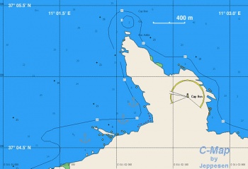
| + | | imagetext= Chart of Cap Bon | ||
| + | }} | ||
| + | [http://en.wikipedia.org/wiki/Cap_Bon Cap Bon] (Cape Bon), also known as Sharik Peninsula or Shariq Peninsula, is a peninsula in far northeastern Tunisia south of the Gulf of Tunis. It is notorious for its high winds and confused seas. Yet on the lee of the cape there is a good anchorage very convenient for boats either to or from [[Sidi Bou Said]], the marina of Tunis. | ||
| - | == | + | ==Charts== |
| - | [ | + | ''See [[Tunisia#Charts|Tunisia]]''. |
| - | == | + | ==Weather== |
| - | See [[Tunisia# | + | ''See [[Tunisia#Weather|Tunisia]]''. |
| - | == | + | ==Passages== |
| - | '' | + | ''See [[Aegean_to_West_Mediterranean_Passages#Southern_Route_Via_Malta_and_S_of_Sicily|Aegean to West Mediterranean Passages]]''. |
| - | + | ==Communication== | |
| + | {{Green|Add here VHF channel for coastguard, harbor masters. etc.}} | ||
* | * | ||
| + | * | ||
| - | == | + | ''Also see [[World MM Nets|World Cruiser's Nets]]'' |
| + | |||
| + | ==Navigation== | ||
Approaching Cap Bon you may experience strong wind and confused seas. | Approaching Cap Bon you may experience strong wind and confused seas. | ||
| - | + | ==Berthing== | |
| - | === | + | ==Anchorages== |
| - | + | [[image:World_icon.png]] {{Coord|37|04.8|N|11|02.2|E|}}<br /> | |
Anchor on the northern lee side of the Cape. Here despite the wind it is usually very calm. There are no facilities here, just a safe anchorage away from everything. | Anchor on the northern lee side of the Cape. Here despite the wind it is usually very calm. There are no facilities here, just a safe anchorage away from everything. | ||
| - | + | {{Warning}}There are large underwater rocks where your anchor or anchor line can foul. Look carefuly where you anchor and allow for a lot of swinging. | |
| - | + | {{hgallery| | |
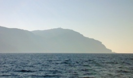
| - | + | {{himage|Tunisia_CapBon1.jpg|Approaching Cap Bon from the East|1600x200px}} | |
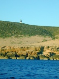
| - | + | {{himage|Tunisia_CapBon2.jpg|The Calm Anchorage under Cap Bon|1600x280px}} | |
| - | + | }} | |
| - | == | + | ==Yacht Repairs and Services== |
| - | + | None. | |
| + | ==Things to do Ashore== | ||
| + | Cannot go ashore, too rough. | ||
| - | == | + | ==Friends== |
| - | + | ||
| - | + | ||
| - | + | ||
Contact details of "Cruiser's Friends" that can be contacted for local information or assistance. | Contact details of "Cruiser's Friends" that can be contacted for local information or assistance. | ||
* | * | ||
| - | == | + | ==Forums== |
| - | List links to discussion threads on | + | List links to discussion threads on [[Cruising Forums|partnering forums]]. (''see link for requirements'') |
| - | + | ||
* | * | ||
* | * | ||
| - | == | + | ==Links== |
| - | * | + | * {{wikipedia}} |
* | * | ||
* | * | ||
| - | == | + | ==References== |
| + | ''See [[Tunisia#References_&_Publications|Tunisia]]''. | ||
| + | |||
| + | {{Comments}} | ||
Personal experiences? | Personal experiences? | ||
| - | * | + | * This is a nice, isolated, place to rest, away from the crowds. --[[User:Istioploos|Istioploos]] [[Image:Greece_Icon.png]] |
| + | * | ||
| - | + | {{Verified by}} | |
| - | + | ||
* June 2001. --[[User:Istioploos|Istioploos]] [[Image:Greece_Icon.png]] | * June 2001. --[[User:Istioploos|Istioploos]] [[Image:Greece_Icon.png]] | ||
* | * | ||
| + | {{Page useable}} | ||
| - | |||
| + | {{Contributors|[[User:Istioploos|Istioploos]]}} | ||
| - | + | [[Category:Anchorages - Tunisia]] | |
| - | + | ||
| - | + | ||
| - | + | ||
| - | + | ||
| - | + | ||
| - | + | ||
Latest revision as of 07:42, 16 August 2018
| Cap Bon
| |
Cap Bon (Cape Bon), also known as Sharik Peninsula or Shariq Peninsula, is a peninsula in far northeastern Tunisia south of the Gulf of Tunis. It is notorious for its high winds and confused seas. Yet on the lee of the cape there is a good anchorage very convenient for boats either to or from Sidi Bou Said, the marina of Tunis.
Charts
See Tunisia.
Weather
See Tunisia.
Passages
See Aegean to West Mediterranean Passages.
Communication
Add here VHF channel for coastguard, harbor masters. etc.
Also see World Cruiser's Nets
Approaching Cap Bon you may experience strong wind and confused seas.
Berthing
Anchorages
![]() 37°04.8′N, 11°02.2′E
37°04.8′N, 11°02.2′E
Anchor on the northern lee side of the Cape. Here despite the wind it is usually very calm. There are no facilities here, just a safe anchorage away from everything.
Warning: There are large underwater rocks where your anchor or anchor line can foul. Look carefuly where you anchor and allow for a lot of swinging.
Yacht Repairs and Services
None.
Things to do Ashore
Cannot go ashore, too rough.
Friends
Contact details of "Cruiser's Friends" that can be contacted for local information or assistance.
Forums
List links to discussion threads on partnering forums. (see link for requirements)
Links
- Cap Bon at the Wikipedia
References
See Tunisia.
Comments
We welcome users' contributions to the Wiki. Please click on Comments to view other users' comments, add your own personal experiences or recommend any changes to this page following your visit. Personal experiences?
- This is a nice, isolated, place to rest, away from the crowds. --Istioploos

Verified by
Date of member's last visit to Cap Bon and this page's details validated:
- June 2001. --Istioploos

| This is a usable page of the cruising guide. However, please contribute if you can to help it grow further. Click on Comments to add your personal notes on this page or to discuss its contents. Alternatively, if you feel confident to edit the page, click on the edit tab at the top and enter your changes directly. |
| |
|---|
|
Names: Istioploos |


