Cythera
From CruisersWiki
(→Last Visited & Details Checked (and updated here)) |
m (Text replace - "==References & Publications==" to "==References==") |
||
| (25 intermediate revisions not shown) | |||
| Line 1: | Line 1: | ||
| - | + | {{IsPartOf|Mediterranean|Ionian Sea|Greece}} | |
| - | {| | + | {{TOC block}} |
| - | | | + | {{Infobox |36|14.89|N|22|59.07|E| |
| - | + | | zoom= 10 | |
| - | + | | chartlet= y | |
| - | + | | image= Kythera_m.jpg | |
| - | + | | imagetext= Map of Cythera | |
| - | | | + | | notes= |
| - | + | | news= | |
| - | | | + | }} |
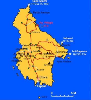
| - | | | + | [http://en.wikipedia.org/wiki/Kythera Cythera] (Κύθηρα) or Kythera or Kithiira or Tsirigo is a small island of 2,500 inhabitants and over 10,000 immigrants to Australia. Tourism here is fairly low key. |
| - | + | ||
| - | + | ||
| - | + | ||
| - | + | ||
| - | + | ||
| - | + | Today, for some mysterious bureaucratic reason, the island is a province of Attica. | |
| - | + | ||
| - | + | ||
==Charts== | ==Charts== | ||
| Line 29: | Line 22: | ||
; Greek | ; Greek | ||
: 431 Monemvasia to Souda Bay | : 431 Monemvasia to Souda Bay | ||
| - | |||
| - | |||
| - | |||
| - | |||
| - | |||
==Weather== | ==Weather== | ||
''See [[South_Peloponnese#Weather|Weather]]''. | ''See [[South_Peloponnese#Weather|Weather]]''. | ||
| - | == | + | ==Passages== |
| - | + | * [[Circumnavigating the Peloponnese]] | |
| - | == | + | ==Islands== |
| - | + | * [[Anticythera]] | |
| - | + | ||
| - | [[ | + | |
| - | + | ||
| - | + | ||
| - | + | ==Communication== | |
| + | ''Also see [[World MM Nets|World Cruiser's Nets]]'' | ||
| + | * Coast Guard - VHF channel 12 | ||
| + | * Olympia Radio - VHF channels 85 & 86 | ||
| - | + | ==Navigation== | |
| + | The approaches to Cythera are straightforward except for possible strong gusts. | ||
| - | + | ==Berthing== | |
| - | + | ===Ports=== | |
| - | + | {{Poi |36|08.6|N|22|59.89|E|| type= harbour | name= Kapsáli |altname= Καψάλι | zoom= 16 | |
| - | + | | image= Greece_Cythera_Kapsali_h.jpg | |
| + | | imagetext= Chart of Kapsáli | ||
| + | | portofentry= | ||
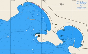
| + | | text= Although there are several anchorages in the island, Kapsáli () is the only one harbor. It is a pleasant small harbor open to the S. There is always some swell here. Sometimes the anchors do not hold in the sand/weed and rock bottom. I find it better, if there is room, to go side-to the quay and use lots of fenders. You can always anchor and go bow or stern-to. | ||
| - | + | {{Danger}}With strong S winds the harbor is untenable. | |
| - | + | ||
| - | + | ||
| - | + | ||
| - | + | {{Warning}}With strong W winds there are fierce gusts and a bad swell develops.}} | |
| - | + | ||
| - | + | ||
| - | + | {{hgallery| | |
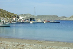
| - | + | {{himage|Kythera2.jpg|The Quay in Kapsáli}} | |
| - | + | }} | |
| - | |||
| - | |||
===Marinas & Yacht Clubs=== | ===Marinas & Yacht Clubs=== | ||
| - | |||
| - | |||
| - | |||
| - | |||
None. | None. | ||
| - | ==== | + | ==Anchorages== |
| - | + | {{Poi |36|13.42|N|23|04.87|E| | type= anchorage| name= Ayios Nikolaos | |
| + | | text= Ayios Nikolaos or Avelomonas is a small natural harbor with a very cute small village with 3 or 4 tavernas, but no shopping of any sort. There are small fishing boats in the harbour, but no room for a yacht. However, the large sandy bay just to the west of it has good holding and provides good protection from westerlies. It is an easy dinghy ride around to the little harbour. }} | ||
| - | == | + | {{Poi |36|16.28|N|23|04.43|E| | type= anchorage| name= Makronisos |
| - | + | | text= The N side of Makronisos or Dhiakofti Island offers good shelter from the SW and W winds. The bottom is sand and provides excellent holding. }} | |
| - | + | ||
| - | + | ||
| - | + | ||
| - | + | ||
| - | + | ||
| - | == | + | {{Poi |36|19.79|N|22|59.04|E| | type= anchorage| name= Ayia Pelagia |
| - | + | | text= Ayia Pelagia is a small port about 4 nM south of Cape Spathi. There are strong SW and W gusts. }} | |
| - | + | {{Danger}}With NE winds the port is untenable. | |
| - | + | ||
| - | + | ||
| - | == | + | ==Amenities== |
| - | + | {{tlist | |
| - | + | |header|Facilities | |
| - | + | ||
| - | + | |Water| In [[#Kapsáli| Kapsáli]] a mini tank delivers, ask at the ''Limenarchio'' (Coast Guard) | |
| - | In | + | |Electricity| None |
| + | |Toilets| None | ||
| + | |Showers| None | ||
| + | |Laundry| | ||
| + | |Garbage| There are bins around the harbors and in several anchorages | ||
| - | + | |header|Supplies | |
| - | + | |Fuel| In [[#Kapsáli| Kapsáli]] a tank delivers at the quay. Call +30 2736 311 164 or +30 6927 953 799. | |
| + | |Bottled gas| In the grocery store in [[#Kapsáli| Kapsáli]] | ||
| + | |Chandlers| None | ||
| - | + | |header|Services | |
| - | + | |Repairs| None | |
| + | |Internet| In Internet cafés | ||
| + | |Mobile connectivity| Good 3G signal | ||
| + | |Vehicle rentals| Car and motor scooter rental towards the fishing harbor in [[#Kapsáli| Kapsáli]] | ||
| + | }} | ||
| - | == | + | ==Provisioning== |
| - | + | {{mark |name= [[#Kapsáli| Kapsáli]]| type= provisions |text= There is good grocery store.}} | |
| - | ==== | + | {{mark | type= provisions |name= Chora | lat=36.15645|lon=22.99559|zoom=14 |text= At least one store.}} |
| + | |||
| + | ==Eating out== | ||
| + | * [[#Kapsáli| Kapsáli]] | ||
| + | {{mark |name= [[#Kapsáli|Harbor]] | type= eatingout | text= Several restaurants.}} | ||
| + | |||
| + | * Chora | ||
| + | {{mark | type= eatingout | name= Chora | lat=36.15645| lon=22.99559|zoom=14 |text= Several restaurants.}} | ||
| + | |||
| + | ==Transportation== | ||
There are daily flights to Athens and hydrofoils to Piraeus. For taxis to Chora or the airport call the friendly Mr. Stathis at +30 2736 311 640 or +30 6977 917 698. | There are daily flights to Athens and hydrofoils to Piraeus. For taxis to Chora or the airport call the friendly Mr. Stathis at +30 2736 311 640 or +30 6977 917 698. | ||
| - | == | + | ==Tourism== |
| - | + | ====History==== | |
| + | The sea of Kythera is the birthplace of [http://www.maicar.com/GML/Aphrodite.html Aphrodite], the goddess of love. According to the mythology she rose from the foam created from the genitalia of [http://www.maicar.com/GML/Uranus.html Uranos] that his son [http://www.maicar.com/GML/Cronos.html Cronos] threw into the sea after castrating him. | ||
| + | |||
| + | The first settlers on the island were [http://en.wikipedia.org/wiki/Phoenicians Phoenicians]. They traded in murex shells – Porphyry in Greek, which gave the island its other name Porhyrousa. The Phoenicians were followed by the [http://en.wikipedia.org/wiki/Minoans Minoans]. They made the island a trading center being at the cross roads between [[Crete]] and the mainland. This strategic location has made Cythera a very valuable property. The island has been invaded 80 times in recorded history. During the 10th century AD the island was continuously being invaded by [http://en.wikipedia.org/wiki/Saracens Saracens] from Crete to the point that its inhabitants abandoned it. The, then [http://en.wikipedia.org/wiki/Byzantine Byzantine] general, and later emperor [http://en.wikipedia.org/wiki/Nikephoros_II Nikephoros Phocas] re-conquered the Cythera and Crete from the Saracens. The rulers of the island were the Byzantine family Eudhaemonoyannis from [[Monemvasia|Monemvasía]]. In 1204 AD the island was occupied by the [http://en.wikipedia.org/wiki/Republic_of_Venice Venetians] but the emperor [http://en.wikipedia.org/wiki/Michael_Paleologos Michael Paleologos] regained it and restored the Eudhaemonoyannis. In 1537 [http://en.wikipedia.org/wiki/Barbarossa_%28Ottoman_admiral%29 Barbarossa] destroyed the island. The [http://en.wikipedia.org/wiki/Republic_of_Venice Venetians] re-took it in the 16th century and re-named it Cerigo (Τσιρίγο) a name still used. The British followed the Venetians and in 1864, along with the other Ionian islands, ceded it to Greece. | ||
| + | |||
| + | ====Places to Visit==== | ||
| + | You should visit Chora. There is a nice cave. | ||
| - | == | + | ==Friends== |
Contact details of "Cruiser's Friends" that can be contacted for local information or assistance. | Contact details of "Cruiser's Friends" that can be contacted for local information or assistance. | ||
| - | == | + | ==Forums== |
List links to discussion threads on [[Cruising Forums|partnering forums]]. (see link for requirements) | List links to discussion threads on [[Cruising Forums|partnering forums]]. (see link for requirements) | ||
* | * | ||
| Line 130: | Line 128: | ||
* | * | ||
| - | == | + | ==Links== |
* [http://en.wikipedia.org/wiki/Kythera Cythera] (Wilipedia) | * [http://en.wikipedia.org/wiki/Kythera Cythera] (Wilipedia) | ||
* | * | ||
* | * | ||
| - | ==References | + | ==References== |
''See [[Greece#References_&_Publications|Greece]]''. | ''See [[Greece#References_&_Publications|Greece]]''. | ||
| - | + | {{Comments}} | |
| - | + | ||
* | * | ||
| - | + | {{Verified by}} | |
| - | + | * May 2001 {{Istioploos2}} | |
| - | * May 2001 | + | * April 2014 --[[User:LifePart2|LifePart2]] [[Image:Canada_Icon.png]] - Visited Agios Nicholaus |
| - | * April 2014 --[[User:LifePart2|LifePart2]] [[Image:Canada_Icon.png]] - | + | * |
| - | + | ||
| - | |||
| + | {{Page useable}} | ||
| - | |||
| - | |||
| - | |||
| - | |||
| - | |||
| - | |||
| - | |||
| - | |||
| - | + | {{Contributors|[[User:Istioploos|Istioploos]], [[User:Lighthouse|Lighthouse]]}} | |
| - | { | + | |
| - | + | ||
| - | + | ||
| - | + | ||
| - | + | ||
| - | + | ||
| - | [[Category:Islands | + | [[Category:Islands - Greece]] |
Latest revision as of 11:47, 15 August 2018
| Cythera
| |
| | |
Cythera (Κύθηρα) or Kythera or Kithiira or Tsirigo is a small island of 2,500 inhabitants and over 10,000 immigrants to Australia. Tourism here is fairly low key.
Today, for some mysterious bureaucratic reason, the island is a province of Attica.
Charts
- BA
- 1030 Southern entrance channels to the Aegean Sea
- Imray-Tetra
- G15 Southern Peloponnisos
- NIMA
- 54303 Lakonikos Kolpos S Greece
- Greek
- 431 Monemvasia to Souda Bay
Weather
See Weather.
Passages
Islands
Communication
Also see World Cruiser's Nets
- Coast Guard - VHF channel 12
- Olympia Radio - VHF channels 85 & 86
The approaches to Cythera are straightforward except for possible strong gusts.
Berthing
Ports
Kapsáli
Although there are several anchorages in the island, Kapsáli () is the only one harbor. It is a pleasant small harbor open to the S. There is always some swell here. Sometimes the anchors do not hold in the sand/weed and rock bottom. I find it better, if there is room, to go side-to the quay and use lots of fenders. You can always anchor and go bow or stern-to.
Danger: With strong S winds the harbor is untenable.
Warning: With strong W winds there are fierce gusts and a bad swell develops.Marinas & Yacht Clubs
None.
Anchorages
Ayios Nikolaos
Makronisos
Ayia Pelagia
Danger: With NE winds the port is untenable.
Amenities
| Facilities | |
|---|---|
| Water | In Kapsáli a mini tank delivers, ask at the Limenarchio (Coast Guard) |
| Electricity | None |
| Toilets | None |
| Showers | None |
| Laundry | |
| Garbage | There are bins around the harbors and in several anchorages |
| Supplies | |
| Fuel | In Kapsáli a tank delivers at the quay. Call +30 2736 311 164 or +30 6927 953 799. |
| Bottled gas | In the grocery store in Kapsáli |
| Chandlers | None |
| Services | |
| Repairs | None |
| Internet | In Internet cafés |
| Mobile connectivity | Good 3G signal |
| Vehicle rentals | Car and motor scooter rental towards the fishing harbor in Kapsáli |
Provisioning
![]() Kapsáli [[Cythera# Kapsáli| Kapsáli]] There is good grocery store.
Kapsáli [[Cythera# Kapsáli| Kapsáli]] There is good grocery store.
![]() Chora [[Cythera#Chora|Chora]] 36°09.387'N, 022°59.735'E At least one store.
Chora [[Cythera#Chora|Chora]] 36°09.387'N, 022°59.735'E At least one store.
Eating out
![]() Harbor [[Cythera#Harbor|Harbor]] Several restaurants.
Harbor [[Cythera#Harbor|Harbor]] Several restaurants.
- Chora
![]() Chora [[Cythera#Chora|Chora]] 36°09.387'N, 022°59.735'E Several restaurants.
Chora [[Cythera#Chora|Chora]] 36°09.387'N, 022°59.735'E Several restaurants.
Transportation
There are daily flights to Athens and hydrofoils to Piraeus. For taxis to Chora or the airport call the friendly Mr. Stathis at +30 2736 311 640 or +30 6977 917 698.
Tourism
History
The sea of Kythera is the birthplace of Aphrodite, the goddess of love. According to the mythology she rose from the foam created from the genitalia of Uranos that his son Cronos threw into the sea after castrating him.
The first settlers on the island were Phoenicians. They traded in murex shells – Porphyry in Greek, which gave the island its other name Porhyrousa. The Phoenicians were followed by the Minoans. They made the island a trading center being at the cross roads between Crete and the mainland. This strategic location has made Cythera a very valuable property. The island has been invaded 80 times in recorded history. During the 10th century AD the island was continuously being invaded by Saracens from Crete to the point that its inhabitants abandoned it. The, then Byzantine general, and later emperor Nikephoros Phocas re-conquered the Cythera and Crete from the Saracens. The rulers of the island were the Byzantine family Eudhaemonoyannis from Monemvasía. In 1204 AD the island was occupied by the Venetians but the emperor Michael Paleologos regained it and restored the Eudhaemonoyannis. In 1537 Barbarossa destroyed the island. The Venetians re-took it in the 16th century and re-named it Cerigo (Τσιρίγο) a name still used. The British followed the Venetians and in 1864, along with the other Ionian islands, ceded it to Greece.
Places to Visit
You should visit Chora. There is a nice cave.
Friends
Contact details of "Cruiser's Friends" that can be contacted for local information or assistance.
Forums
List links to discussion threads on partnering forums. (see link for requirements)
Links
- Cythera (Wilipedia)
References
See Greece.
Comments
We welcome users' contributions to the Wiki. Please click on Comments to view other users' comments, add your own personal experiences or recommend any changes to this page following your visit.
Verified by
Date of member's last visit to Cythera and this page's details validated:
- May 2001 --Istioploos

 Travels with S/Y Thetis
- April 2014 --LifePart2
 - Visited Agios Nicholaus
| This is a usable page of the cruising guide. However, please contribute if you can to help it grow further. Click on Comments to add your personal notes on this page or to discuss its contents. Alternatively, if you feel confident to edit the page, click on the edit tab at the top and enter your changes directly. |
| |
|---|
|
Names: Istioploos, Lighthouse |


