Donousa
From CruisersWiki
Istioploos (Talk | contribs) (Added Infobox) |
Istioploos (Talk | contribs) m (→Charts: Cosmetic) |
||
| Line 16: | Line 16: | ||
===Charts=== | ===Charts=== | ||
| - | + | BA 2682 Kólpos Patalion to Nísos Nísiros<br/> | |
| - | + | BA 1040 Nísos Íos to Vrakhonisídha Kandhelioússa | |
| - | + | ||
| - | + | ||
| - | + | Imray-Tetra G34 Southern Cyclades (West)<br/> | |
| - | + | NIMA 54412 Nisos Amorgos & Plans in Astipalaia | |
| - | + | ||
| + | Greek 42 Andros to Chalki Island<br/> | ||
| + | Greek 423 Paros to Astypalia | ||
===Radio Nets=== | ===Radio Nets=== | ||
Revision as of 16:49, 26 April 2009
Donousa
| | Coords: 37°05.9′N, 25°47.7′E Chartlet: Chartlet Gallery: Photos |
Background
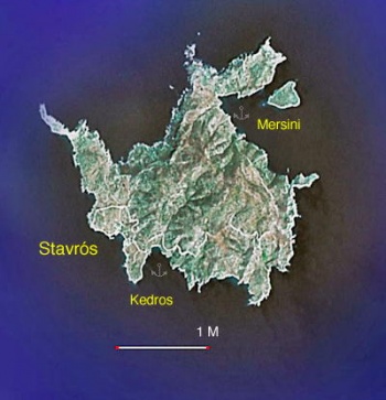
Donousa (Δονούσα) or Dhenoussa has an area of 13.75 km2, a 480 m peak, and altogether 110 inhabitants living in 4 villages: Stavros, Panagia, Mersini, and Mearia. It has a grade school and a middle school with 6 students!
During the summer in Stavros there are 3 restaurants, a rather sophisticated bakery, and at least 2 grocery stores, other than that there are no facilities.
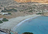
The beach at Stavros is also very attractive but, unlike in Dendro, nudism and camping are discouraged.
Charts
BA 2682 Kólpos Patalion to Nísos Nísiros
BA 1040 Nísos Íos to Vrakhonisídha Kandhelioússa
Imray-Tetra G34 Southern Cyclades (West)
NIMA 54412 Nisos Amorgos & Plans in Astipalaia
Greek 42 Andros to Chalki Island
Greek 423 Paros to Astypalia
Radio Nets
Also see Cruiser's Nets
- Olympia Radio - VHF no signal
Approaches to Donousa are straightforward.
Anchorages
Stavros
| GPS: 37°05.9′N, 25°47.7′E
Stavros (Σταυρός) is the harbor of Donousa. It has a small quay where one can go stern-to, however, the harbor is not well protected and receives a good amount of swell. Not recommended. |
Dendro
| GPS: 37°05.7′N, 25°48.2′E
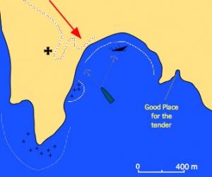
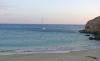
This cove is called Dendro (Δέντρο) or Kedhros (Κέδρος) or Kentro (Κέντρο) (all these names are in use). It is very safe even with gale force meltemi. Drop anchor near the wreck at 4.5 m, if there is a strong wind use a 2nd anchor. The bottom is rocky and the holding is not uniform. Find a sandy spot to drop the anchors, and always check them with mask and snorkel. When there is strong wind, there can be appreciable surf which makes landing with the dinghy a rather wet affair. In this case it is best to land in the tiny inlet on the east of the beach. The sand at the Dendro cove is fine and clean. On the beach in the summer there is a nudist camp but the nudists do not bother anyone, nor do they dirty the beach or make any noise. Unfortunately now there is a small taverna which spoils this previously pristine beach. From here the village of Stavros is about a 20 minute walk. |
Roussa
GPS: 37°07.4′N, 25°49.3′E
This lovely bay is under the village of Mersini on north-east corner of the island. It provides an excellent shelter from the meltemi but because of the rocky bottom the holding may not be very good.
Routes/Passages To/From
Popular passages/routes, timing, etc.
Tourism & things to do ashore
One can take nice long walks on the island. The village of Mersini is particularly attractive in a very rustic way.
Fuel, Water, & Electricity
N/A.
Laundry
N/A.
Grocery Stores
- There are two stores in Stavros with some basic provisions
- There is a surprising good bakery in Stavros but it operates only during the summer months
Eateries
- There are three restaurants in Stavros
- The Captan Yiorgis is quite good
- The one on the E of the beach can be very good, and affords spectacular views of the sunset.
Motorbike & Car Rentals
N/A.
Marine Stores & Facilities
None.
Repairs
N/A.
Transportation
There is a small ferry to/from Naxos and Amorgos.
References & Publications
See Greece.
Cruiser's Friends
Contact details of "Cruiser's Friends" that can be contacted for local information or assistance.
Forum Discussions
List links to discussion threads on the Cruiser Log Forum
External Links
- Donousa (Wikipedia)
Personal Notes
Personal experiences?
Last Visited & Details Checked (and updated here)
Date of member's visit to this Port/Stop & this page's details validated:
- October 2007 --Istioploos 19:30, 27 August 2008 (UTC)
| |
|---|
| | HOMEPAGE | Wiki Contents | Mediterranean | Aegean Sea | Greece | Donousa | |
.


