Eregli
From CruisersWiki
Istioploos (Talk | contribs) (Headings) |
m (Text replace - "==Communication== * * ''Also see World Cruiser's Nets''. " to "==Communication== * ''Also see World Cruiser's Nets''. ") |
||
| (24 intermediate revisions not shown) | |||
| Line 1: | Line 1: | ||
| - | + | {{IsPartOf|Black Sea|Turkey|}} | |
| - | { | + | {{TOC block}} |
| - | + | ||
| - | + | ||
| - | | | + | |
| - | + | ||
| - | | | + | |
| - | + | ||
| - | + | ||
| - | + | ||
| - | + | ||
| - | + | ||
| - | + | ||
| - | + | ||
| - | + | ||
| - | + | ||
| - | + | {{Infobox | lat=41.275 | lon=31.41 | |
| - | + | | zoom= 13 | |
| - | + | | chartlet= y | |
| - | + | | portofentry= y | |
| - | + | | image= Turkey_Eregli_h.jpg | |
| - | + | | imagetext= Chart of Eregli Harbor | |
| + | }} | ||
| + | [http://en.wikipedia.org/wiki/Eregli Eregli] is a large military and industrial harbor. As you enter the harbor with its large steel mills, the largest in the Middle East, appears as the entrance to a modern version of hell. It is a very large harbor, busy with many large ships, some docked some moored off-shore. Despite the amount of shipping the harbor is actually not as dirty as [[Samsun]]. Nor does the town look as bad as the first impression. The mills are all at the western end and the town seems to have a large promenade shaded with trees at its eastern end. The town has some green parks, and is built amphitheatrically. | ||
==Charts== | ==Charts== | ||
| Line 34: | Line 22: | ||
: 113 Eregli-Amasra | : 113 Eregli-Amasra | ||
| - | == | + | ==Weather== |
| + | ''See [[Turkey#Turkey_Climate_&_Weather|Turkey]]''. | ||
| + | |||
| + | ==Passages== | ||
| + | Popular passages/routes, timing, etc. | ||
* | * | ||
| + | |||
| + | ==Islands== | ||
| + | {{Poi |41|12.7|N|30|15.5|E| | type= island | name= Kefken Adasi | zoom= 15 | ||
| + | | image= Turkey_Kefken_S.jpg | ||
| + | | imagetext= Satellite View of Kefken Adasi | ||
| + | | text= Kefken Adasi is 52.4 nM E of Eregli. The cove is fairly peaceful. The island is low lying and marred by a fish farm and a concrete quay. The mainland just across is green and attractive.}} | ||
| + | |||
| + | ==Communication== | ||
* | * | ||
''Also see [[World MM Nets|World Cruiser's Nets]]''. | ''Also see [[World MM Nets|World Cruiser's Nets]]''. | ||
| - | == | + | ==Navigation== |
| - | + | The approaches to Amasra are straightforward. | |
| - | |||
| - | |||
| - | == | + | ==Entrance== |
| - | [[#Eregli Harbor|Eregli]] is a port of entry/exit to Turkey. | + | [[#Eregli Harbor|Eregli]] is a port of entry/exit to [[Turkey]]. |
| - | ==Berthing | + | ==Berthing== |
===Ports=== | ===Ports=== | ||
| - | + | {{Poi |41|16.5|N|31|24.6|E| | type= harbour | name= Eregli Harbor | |
| - | + | | text= Eregli Harbour is large harbour with many large commercial ships and a number of fishing boats. Anchor off in the east side of the harbor north of the commercial wharves and fishing harbour in 5 to 7 metres just west of the the yachts on moorings and sailing club. Keep clear of commercial boats. Good holding. Sailing club is very helpful and welcoming. | |
| - | Eregli Harbour is large harbour with many large commercial ships and a number of fishing boats. Anchor off in the east side of the harbor north of the commercial wharves and fishing harbour in 5 to 7 metres just west of the the yachts on moorings and sailing club. Keep clear of commercial boats. Good holding. Sailing club is very helpful and welcoming. | + | |
| - | {{ | + | {{Warning}} Do not approach the northern and north western side of the harbor where the Turkish Navy and coastguard has a base.}} |
| - | + | {{hgallery| | |
| - | + | {{himage|Turkey_Eregli_1.jpg|Entering Eregli Harbor}} | |
| - | + | {{himage|Turkey_Eregli_2.jpg|Sunset at Eregli}} | |
| - | + | }} | |
===Marinas & Yacht Clubs=== | ===Marinas & Yacht Clubs=== | ||
None. | None. | ||
| - | + | ==Anchorages== | |
| - | + | {{Poi |41|10.7|N|29|36.30|E | type= anchorage | name= Sile | zoom= 16 | |
| - | + | | image= Turkey_Sile_S.jpg | |
| - | + | | imagetext= Satellite View of Sile | |
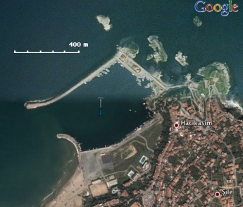
| - | + | | text= [http://en.wikipedia.org/wiki/Sile Sile] is Black Sea low key resort and a fishing town not very far from [[Bosphorus]]. | |
| - | [http://en.wikipedia.org/wiki/Sile Sile] is Black Sea low key resort and a fishing town not very far from [[Bosphorus]]. | + | |
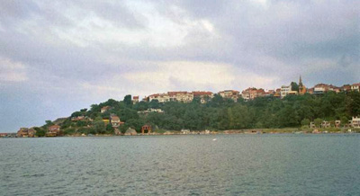
The town is up the hill along a palisade and it is very attractive. There is at least one good good restaurant along the water front in the south east corner of the harbour. | The town is up the hill along a palisade and it is very attractive. There is at least one good good restaurant along the water front in the south east corner of the harbour. | ||
| Line 76: | Line 72: | ||
In quiet conditions it is possible to anchor just west of the harbour. It is best to enter the harbor and anchor off in 6 m, just to the right of the W jetty or just west of the small internal fishing harbour. The bottom is full of weed and while the holding is good the chain will be completely coated by a thin green weed the consistency of cotton candy. | In quiet conditions it is possible to anchor just west of the harbour. It is best to enter the harbor and anchor off in 6 m, just to the right of the W jetty or just west of the small internal fishing harbour. The bottom is full of weed and while the holding is good the chain will be completely coated by a thin green weed the consistency of cotton candy. | ||
| - | The south side of the harbour is very shallow. The break water has been recently extended so that there is a smaller entrance to the harbour. Some guides indicate a very shallow entrance and that you must enter if you have a draft of more than 2m on the northern side. As at July 2011 the middle of the entrance to the harbour is 5 m. | + | The south side of the harbour is very shallow. The break water has been recently extended so that there is a smaller entrance to the harbour. Some guides indicate a very shallow entrance and that you must enter if you have a draft of more than 2m on the northern side. As at July 2011 the middle of the entrance to the harbour is 5 m.}} |
| - | + | {{Image center|Turkey_Sile1.jpg |Approaching Sile |400px }} | |
| - | |||
| - | |||
| - | |||
| - | + | ==Amenities== | |
| - | + | {{tlist | |
| - | + | |header|Facilities | |
| - | + | ||
| - | + | ||
| - | + | |Water| N/A (Not Available) | |
| - | + | |Electricity| N/A | |
| + | |Toilets| N/A | ||
| + | |Showers| N/A | ||
| + | |Laundry| N/A | ||
| + | |Garbage| Trash cans | ||
| - | + | |header|Supplies | |
| - | + | |Fuel| N/A | |
| - | + | |Bottled gas| N/A | |
| - | + | |Chandlers| None | |
| - | + | ||
| - | + | ||
| - | + | ||
| - | + | |header|Services | |
| - | + | |Repairs| N/A | |
| - | + | |Internet| Free internet is available from the sailing club | |
| + | |Mobile connectivity| {{Green|Is there mobile telephone signal such as G4, G3, GPRS in the island? How strong is the signal? Are there any blind spots?}} | ||
| + | |Vehicle rentals| {{Green|Are cars, motorbikes, and bicycles available for rent? If so give the name, location, tel number of the rental outlets.}} | ||
| + | }} | ||
| - | == | + | ==Provisioning== |
Several stores in town. | Several stores in town. | ||
| - | == | + | ==Eating out== |
A number of attractive waterfront restaurants. | A number of attractive waterfront restaurants. | ||
| - | == | + | ==Transportation== |
| - | + | Busses to [[Istanbul]] and other cities. | |
| - | ==== | + | ==Tourism== |
| - | + | ====History==== | |
| + | Eregli the ancient Greek [http://en.wikipedia.org/wiki/Heraclea_Pontica Herakleia] (Ηράκλεια Ποντική - Heraclea Pontica) was founded in the 6th century BC by Greeks from [http://en.wikipedia.org/wiki/Megara Megara] and [http://en.wikipedia.org/wiki/Tanagra Tanagra]. It became one of the most important commercial and cultural centers in the Hellenic Black Sea. It was believed to have been near one of the entrances to [http://en.wikipedia.org/wiki/Hades Hades], the very entrance that [http://en.wikipedia.org/wiki/Hades Hades], the very entrance that [http://www.maicar.com/GML/Heracles1.html Hercules] used to enter [http://www.maicar.com/GML/Hades.html Hades] in his labor of fetching the three headed dog [http://en.wikipedia.org/wiki/Cerberos Cerberos]. [http://en.wikipedia.org/wiki/Xenophon Xenophon] in 355 BC, on his way back to Greece, stopped at Herakleia and was shown the place on the [http://en.wikipedia.org/wiki/Acherusia Acherusian peninsula] (Cape Baba) where Hercules entered Hades. | ||
| - | + | In 364-353 BC Herakleia was ruled by the tyrant [http://en.wikipedia.org/wiki/Clearchus_of_Heraclea Clearchos] who was credited with liberating the serfs and building the first public library. His dynasty stayed in power until 288 BC. His son [http://en.wikipedia.org/wiki/Dionysius_of_Heraclea Dionysios] ruled over several cities including Sesamos and Tieum. He was married to [[http://en.wikipedia.org/wiki/Amastris Amastris] the founder of Amastris (modern [[Amasra]]). In [http://en.wikipedia.org/wiki/Roman_Republic Roman] times, Herakleia was an ally of [http://en.wikipedia.org/wiki/Mithridates_VI_of_Pontus Mithridates Eupator] (ca 120-63 BC) and as a result was razed to the ground by the Roman general Cotta. [http://en.wikipedia.org/wiki/Strabo Strabo] describes it as a city with a good harbor. The [http://en.wikipedia.org/wiki/Byzantine_Empire%20Byzantine Byzantines] built a citadel here. In 1360 AD the town was taken by the Turks but was also used by the [http://en.wikipedia.org/wiki/Genoa_Republic Genoese] as a trading post. It was later incorporated into the [http://en.wikipedia.org/wiki/Ottoman_Empire Ottoman Empire]. In 1922 its sizable Greek population was forced to abandon their homes, under the [http://en.wikipedia.org/wiki/Exchange_of_populations_between_Greece_and_Turkey Greek-Turkish treaty]. | |
| - | + | ||
| - | + | There were many famous people from Herakleia including [http://en.wikipedia.org/wiki/Heraclides_Ponticus Heracleides Pontico]s (ca 390-310 BC) who was a student of [http://en.wikipedia.org/wiki/Plato Plato] and proposed the [http://en.wikipedia.org/wiki/Heliocentric Heliocentric system,] and [http://en.wikipedia.org/wiki/Dionysius_the_Renegade Dionysios of Herakleia] (c 330-250 BC) who was a [http://en.wikipedia.org/wiki/Stoic stoic philosopher] and friend of [http://en.wikipedia.org/wiki/Zeno_of_Citium Zenon], the founder of stoicism. | |
| - | + | ||
| - | ==== | + | ====Places to Visit==== |
| - | + | In the outskirts of Eregli there is a cave, the cave of [http://www.maicar.com/GML/Heracles1.html Hercules] which is believed to be the entrance to [http://en.wikipedia.org/wiki/Hades Hades]. | |
| - | + | ||
| - | + | ||
| - | + | ||
| - | + | ||
| - | == | + | ==Friends== |
Contact details of "Cruiser's Friends" that can be contacted for local information or assistance. | Contact details of "Cruiser's Friends" that can be contacted for local information or assistance. | ||
* | * | ||
| - | == | + | ==Forums== |
List links to discussion threads on [[Cruising Forums|partnering forums]]. (''see link for requirements'') | List links to discussion threads on [[Cruising Forums|partnering forums]]. (''see link for requirements'') | ||
* | * | ||
* | * | ||
| - | == | + | ==Links== |
| - | * | + | * {{wikipedia|Karadeniz_Ereğli}} |
| - | * | + | * {{Wikipedia|Heraclea_Pontica|Heraclea Pontica}} |
| - | * | + | * {{Wikipedia|Şile|Sile}} |
* | * | ||
| Line 149: | Line 139: | ||
''See [[Turkey#References_&_Publications|Turkey]] & the [[Black Sea#References_&_Publications|Black Sea]]''. | ''See [[Turkey#References_&_Publications|Turkey]] & the [[Black Sea#References_&_Publications|Black Sea]]''. | ||
| - | + | {{Comments}} | |
| - | + | ||
* | * | ||
| - | + | {{Verified by}} | |
| - | + | * August 1999 {{Istioploos2}} | |
| - | * August 1999 | + | |
* | * | ||
| - | {{ | + | {{Page useable}} |
| - | + | ||
| - | |||
| - | |||
| - | |||
| - | |||
| - | |||
| - | |||
| - | |||
| - | |||
| - | + | {{Contributors|[[User:Lighthouse|Lighthouse]], [[User:Istioploos|Istioploos]], [[User:Rr7|Rr7]]}} | |
| - | { | + | |
| - | + | ||
| - | + | ||
| - | + | ||
| - | + | ||
| - | [[Category:Ports | + | [[Category:Ports - Turkey]] [[Category:Ports - Black Sea]] |
Latest revision as of 10:06, 22 August 2018
| Eregli Port of Entry
| |
| | |
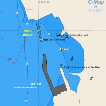
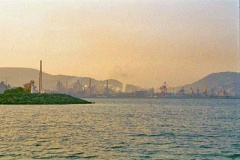
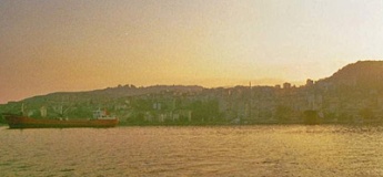
Eregli is a large military and industrial harbor. As you enter the harbor with its large steel mills, the largest in the Middle East, appears as the entrance to a modern version of hell. It is a very large harbor, busy with many large ships, some docked some moored off-shore. Despite the amount of shipping the harbor is actually not as dirty as Samsun. Nor does the town look as bad as the first impression. The mills are all at the western end and the town seems to have a large promenade shaded with trees at its eastern end. The town has some green parks, and is built amphitheatrically.
Charts
- BA
- 2214 The Euxine or Black Sea
- 2238 Kefken Adasi to Inceburun
- 1275 Ereğli to Amasra
- NIMA
- 55100 Western Part of the Black Sea
- Turkey
- 112 Kefken-Eregli
- 113 Eregli-Amasra
Weather
See Turkey.
Passages
Popular passages/routes, timing, etc.
Islands
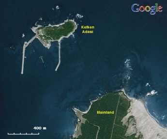
Kefken Adasi
Communication
Also see World Cruiser's Nets.
The approaches to Amasra are straightforward.
Entrance
Eregli is a port of entry/exit to Turkey.
Berthing
Ports
Eregli Harbor
Eregli Harbour is large harbour with many large commercial ships and a number of fishing boats. Anchor off in the east side of the harbor north of the commercial wharves and fishing harbour in 5 to 7 metres just west of the the yachts on moorings and sailing club. Keep clear of commercial boats. Good holding. Sailing club is very helpful and welcoming.
Warning: Do not approach the northern and north western side of the harbor where the Turkish Navy and coastguard has a base.Marinas & Yacht Clubs
None.
Anchorages
Sile
Sile is Black Sea low key resort and a fishing town not very far from Bosphorus.
The town is up the hill along a palisade and it is very attractive. There is at least one good good restaurant along the water front in the south east corner of the harbour.
In quiet conditions it is possible to anchor just west of the harbour. It is best to enter the harbor and anchor off in 6 m, just to the right of the W jetty or just west of the small internal fishing harbour. The bottom is full of weed and while the holding is good the chain will be completely coated by a thin green weed the consistency of cotton candy.
The south side of the harbour is very shallow. The break water has been recently extended so that there is a smaller entrance to the harbour. Some guides indicate a very shallow entrance and that you must enter if you have a draft of more than 2m on the northern side. As at July 2011 the middle of the entrance to the harbour is 5 m.
Amenities
| Facilities | |
|---|---|
| Water | N/A (Not Available) |
| Electricity | N/A |
| Toilets | N/A |
| Showers | N/A |
| Laundry | N/A |
| Garbage | Trash cans |
| Supplies | |
| Fuel | N/A |
| Bottled gas | N/A |
| Chandlers | None |
| Services | |
| Repairs | N/A |
| Internet | Free internet is available from the sailing club |
| Mobile connectivity | Is there mobile telephone signal such as G4, G3, GPRS in the island? How strong is the signal? Are there any blind spots? |
| Vehicle rentals | Are cars, motorbikes, and bicycles available for rent? If so give the name, location, tel number of the rental outlets. |
Provisioning
Several stores in town.
Eating out
A number of attractive waterfront restaurants.
Transportation
Busses to Istanbul and other cities.
Tourism
History
Eregli the ancient Greek Herakleia (Ηράκλεια Ποντική - Heraclea Pontica) was founded in the 6th century BC by Greeks from Megara and Tanagra. It became one of the most important commercial and cultural centers in the Hellenic Black Sea. It was believed to have been near one of the entrances to Hades, the very entrance that Hades, the very entrance that Hercules used to enter Hades in his labor of fetching the three headed dog Cerberos. Xenophon in 355 BC, on his way back to Greece, stopped at Herakleia and was shown the place on the Acherusian peninsula (Cape Baba) where Hercules entered Hades.
In 364-353 BC Herakleia was ruled by the tyrant Clearchos who was credited with liberating the serfs and building the first public library. His dynasty stayed in power until 288 BC. His son Dionysios ruled over several cities including Sesamos and Tieum. He was married to [Amastris the founder of Amastris (modern Amasra). In Roman times, Herakleia was an ally of Mithridates Eupator (ca 120-63 BC) and as a result was razed to the ground by the Roman general Cotta. Strabo describes it as a city with a good harbor. The Byzantines built a citadel here. In 1360 AD the town was taken by the Turks but was also used by the Genoese as a trading post. It was later incorporated into the Ottoman Empire. In 1922 its sizable Greek population was forced to abandon their homes, under the Greek-Turkish treaty.
There were many famous people from Herakleia including Heracleides Ponticos (ca 390-310 BC) who was a student of Plato and proposed the Heliocentric system, and Dionysios of Herakleia (c 330-250 BC) who was a stoic philosopher and friend of Zenon, the founder of stoicism.
Places to Visit
In the outskirts of Eregli there is a cave, the cave of Hercules which is believed to be the entrance to Hades.
Friends
Contact details of "Cruiser's Friends" that can be contacted for local information or assistance.
Forums
List links to discussion threads on partnering forums. (see link for requirements)
Links
- Eregli at the Wikipedia
- Heraclea Pontica at the Wikipedia
- Sile at the Wikipedia
References & Publication
Comments
We welcome users' contributions to the Wiki. Please click on Comments to view other users' comments, add your own personal experiences or recommend any changes to this page following your visit.
Verified by
Date of member's last visit to Eregli and this page's details validated:
- August 1999 --Istioploos

 Travels with S/Y Thetis
| This is a usable page of the cruising guide. However, please contribute if you can to help it grow further. Click on Comments to add your personal notes on this page or to discuss its contents. Alternatively, if you feel confident to edit the page, click on the edit tab at the top and enter your changes directly. |
| |
|---|
|
Names: Lighthouse, Istioploos, Rr7 |
