Glorieuses Islands
From CruisersWiki
Lighthouse (Talk | contribs) |
Lighthouse (Talk | contribs) (→References & Publications) |
||
| Line 51: | Line 51: | ||
===References & Publications=== | ===References & Publications=== | ||
| - | + | * [http://www.cruisingconnections.co.za/books5.htm Islands and Atolls in the Mozambique Channel] Cruising Notes by Tony Herrick. | |
| - | * | + | |
* | * | ||
* | * | ||
Revision as of 11:23, 2 October 2008
Contents
|
Glorieuses Islands, Mozambique Channel
Background
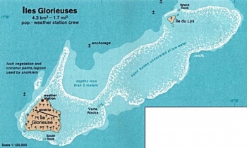
The Glorieuses or Glorioso Islands (French: Îles Glorieuses or officially also Archipel des Glorieuses) are a group of French islands and rocks totalling 5 km², at 11°33′S 47°20′E, in the northern Mozambique Channel, about 160 km northwest of Madagascar. The Glorieuses have an Exclusive Economic Zone (EEZ) of 48,350 km². There are anchorages offshore, and Grande Glorieuse has a 1,300-metre-long airstrip.
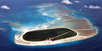
The archipelago consists of two islands, Grande Glorieuse and Île du Lys, as well as eight rock islets (Roches Vertes): Wreck Rock, South Rock and Verte Rocks (three) and three others that are unnamed. They form part of a coral reef and lagoon. Grande Glorieuses is roughly circular and measures about 3 km across. It is thickly vegetated, mainly by the remains of a coconut plantation and casuarina trees.
Île du Lys, about five miles northeast of Grande Glorieuses, is about 600 metres long and consists of sand dunes and scrub with some mangroves. It was formerly quarried for phosphate (guano).
The Glorieuses were named and settled in 1880 by a Frenchman, Hippolyte Caltaux, who established a coconut and maize plantation on Grande Glorieuse. The archipelago became a French possession in 1892. From 1914 to 1958 concessions to exploit the islands were given to Seychelles companies.
The islands are today nature reserves with a meteorological station garrisoned by French troops (The French Foreign Legion). They are claimed by Madagascar (because of their strategic importance), the Seychelles (considering the islands part of the Seychelles Archipelago) and the Comoros (considering the islands part of the Comoros Archipelago).
The terrain is low and flat, varying from sea level to 12 m. Île de Lys in particular is a nesting ground for migratory seabirds, and turtles lay eggs on the beaches.
Charts
Submit the chart details that are required for safe navigation.
Radio Nets
Also see Cruiser's Nets
Weather
The climate is tropical.
Sources for Weather forecasts:
Details?
Anchorages
List details of all safe anchorages in the area.
Things to do
Fuel, Water, & Electricity
Routes/Passages To/From
Popular passages/routes, timing, etc.
References & Publications
- Islands and Atolls in the Mozambique Channel Cruising Notes by Tony Herrick.
Forum Discussions
List links to discussion threads on the Cruiser Log Forum
External Links
Links to relevant websites.
Personal Notes
Personal experiences?
Last Visited & Details Checked (and updated here)
Date of member's visit to this Port/Stop & this page's details validated:
| |
|---|
| | HOMEPAGE | Wiki Contents | Africa | East Africa | Mozambique | Madagascar | Mozambique Channel | Glorieuses Islands | |
.

