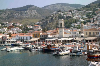
Hydra
From CruisersWiki
Istioploos (Talk | contribs) m (Cosmetic) |
Istioploos (Talk | contribs) (Chartlet) |
||
| Line 1: | Line 1: | ||
| - | + | {{Infobox |37|21.1|N|23|28|E | |
| - | + | | mapzoom= 12 | |
| - | + | | image= Greece_Hydra_m.jpg | |
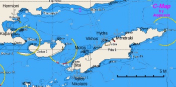
| - | + | | imagetext= Chart of Hydra and its region - ''Click for larger view'' | |
| - | + | }}{{TOCleft}} | |
| - | + | [http://en.wikipedia.org/wiki/Hydra%2C_Saronic_Islands Hydra] or Idhra (Ύδρα) is a very popular and picturesque island on the NW of [http://en.wikipedia.org/wiki/Peloponnese Peloponnese]. | |
| - | + | ||
| - | | | + | |
| - | + | ||
| - | + | ||
| - | | | + | |
| - | + | ||
| - | + | ||
| - | | | + | |
| - | + | ||
| - | + | ||
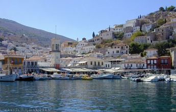
| - | + | {{Image right|Hydra1.jpg |The Harborof Hydra - ''Click for larger view'' }} | |
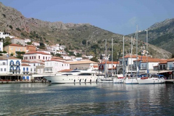
| - | + | {{Image right|Hydra.jpeg |Hydra harbor - ''Click for larger view'' }} | |
Hydra as well as with [[Spetses]] and [[Psara]] were the most important Greek sea powers during the [http://en.wikipedia.org/wiki/Greek_Revolution 1821 revolution] which resulted in Greece's independence from the [http://en.wikipedia.org/wiki/Ottomans Ottoman] rule. Hydra not only had the largest fleet of sailing vessels but was the home of [http://en.wikipedia.org/wiki/Andreas_Miaoulis Admiral Miaoulis] and many other important captains. | Hydra as well as with [[Spetses]] and [[Psara]] were the most important Greek sea powers during the [http://en.wikipedia.org/wiki/Greek_Revolution 1821 revolution] which resulted in Greece's independence from the [http://en.wikipedia.org/wiki/Ottomans Ottoman] rule. Hydra not only had the largest fleet of sailing vessels but was the home of [http://en.wikipedia.org/wiki/Andreas_Miaoulis Admiral Miaoulis] and many other important captains. | ||
| Line 34: | Line 24: | ||
; Greek | ; Greek | ||
: 415 Ydra to Sikinos | : 415 Ydra to Sikinos | ||
| - | |||
==Radio Nets== | ==Radio Nets== | ||
| Line 47: | Line 36: | ||
==Approach and Navigation== | ==Approach and Navigation== | ||
The approaches to Hydra present no problems other then the heavy and at times chaotic traffic to and from the harbor to the mainland. | The approaches to Hydra present no problems other then the heavy and at times chaotic traffic to and from the harbor to the mainland. | ||
| + | {{hold vertical}} | ||
==Berthing Options== | ==Berthing Options== | ||
===Ports=== | ===Ports=== | ||
====Hydra Harbor==== | ====Hydra Harbor==== | ||
| - | + | {{Infobox |37|21.11|N|23|27.96|E | |
| - | + | | name= Hydra Harbor | |
| - | + | | mapzoom= 17 | |
| + | | image= Greece_Hydra_h.jpg | ||
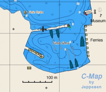
| + | | imagetext= Chart of Hydra harbor - ''Click for larger view'' | ||
| + | }} | ||
The harbor of Hydra is always very crowded in high season and is best avoided at that time. Early spring is the best time to visit, when it is usually possible to moor either on the south quay or the inside of the north breakwater (where, however, it shallows as you go further in). In peak season, it is not unusual for boats to be moored three deep on the quay. | The harbor of Hydra is always very crowded in high season and is best avoided at that time. Early spring is the best time to visit, when it is usually possible to moor either on the south quay or the inside of the north breakwater (where, however, it shallows as you go further in). In peak season, it is not unusual for boats to be moored three deep on the quay. | ||
| Line 64: | Line 57: | ||
=====Last Visited & Details Checked (and updated here)===== | =====Last Visited & Details Checked (and updated here)===== | ||
''Date of member's visit to this Port/Stop & this page's details validated'': | ''Date of member's visit to this Port/Stop & this page's details validated'': | ||
| - | * September 2001 | + | * September 2001 {{Istioploos2}} |
* May 2006 --[[User:Atheneoflymington|Athene of Lymington]] | * May 2006 --[[User:Atheneoflymington|Athene of Lymington]] | ||
* September 2013 --[[User:Maelms|Maelms]] [[Image:Norway Icon.png]] [[File:Sailboat_favicon.png]] [http://viseiler.com Vi Seiler] | * September 2013 --[[User:Maelms|Maelms]] [[Image:Norway Icon.png]] [[File:Sailboat_favicon.png]] [http://viseiler.com Vi Seiler] | ||
| + | * | ||
===Marinas & Yacht Clubs=== | ===Marinas & Yacht Clubs=== | ||
| Line 72: | Line 66: | ||
===Anchorages=== | ===Anchorages=== | ||
| - | + | {{Poi|37|21.33|N|23|28.9|E| | type= anchorage| name= Mandraki | |
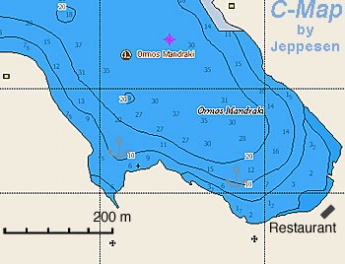
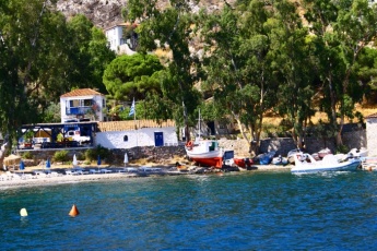
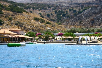
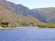
| - | + | | text= Mardraki is an attractive anchorage less than a mile E of [[#Hydra_Harbor|Hydra Harbor]]. It is exposed, however, to the N. Anchor in 3-6 m over sand, weed, and mud. There is a water taxi service to the harbor. }} | |
| - | + | {{Image right|Greece_Hydra_Mandraki_h.jpg |Chart of Mandraki - ''Click for larger view'' }} | |
| - | + | {{Image right|mandrakihydra.jpg |Mandraki bay - ''Click for larger view'' }} | |
| - | + | {{Image right|mandrakihydra2.jpg |Mandraki bay - ''Click for larger view'' }} | |
| - | + | ||
| - | Mardraki is an attractive anchorage less than a mile E of [[#Hydra_Harbor|Hydra Harbor]]. It is exposed, however, to the N. Anchor in 3-6 m over sand, weed, and mud. There is a water taxi service to the harbor. | + | |
{{Warning}}The water taxis create a strong wake as the zoom by. | {{Warning}}The water taxis create a strong wake as the zoom by. | ||
| Line 84: | Line 76: | ||
=====Last Visited & Details Checked (and updated here)===== | =====Last Visited & Details Checked (and updated here)===== | ||
''Date of member's visit to this Port/Stop & this page's details validated'': | ''Date of member's visit to this Port/Stop & this page's details validated'': | ||
| - | * 1989 | + | * 1989 {{Istioploos2}} |
* July 2013 --[[User:Maelms|Maelms]] [[Image:Norway Icon.png]] [[File:Sailboat_favicon.png]] [http://viseiler.com Vi Seiler] | * July 2013 --[[User:Maelms|Maelms]] [[Image:Norway Icon.png]] [[File:Sailboat_favicon.png]] [http://viseiler.com Vi Seiler] | ||
* | * | ||
| + | {{hold vertical}} | ||
| - | + | {{Poi |37|19.92|N|23|25.7|E| | type= anchorage| name= Vikhos | |
| - | + | | text= Anchor in front of the hamlet. The anchorage is exposed, however, to the N. Anchor in 3-6 m over sand, weed, and mud. There is a water taxi service to the harbor. }} | |
| - | Anchor in front of the hamlet. The anchorage is exposed, however, to the N. Anchor in 3-6 m over sand, weed, and mud. There is a water taxi service to the harbor. | + | |
{{Warning}}The water taxis create a strong wake as the zoom by. | {{Warning}}The water taxis create a strong wake as the zoom by. | ||
| Line 98: | Line 90: | ||
* September 2001 --[[User:Istioploos|Istioploos]] [[Image:Greece_Icon.png]] | * September 2001 --[[User:Istioploos|Istioploos]] [[Image:Greece_Icon.png]] | ||
* | * | ||
| - | + | ||
| - | + | {{Poi |37|19.6|N|23|24.75|E| | type= anchorage| name= Molos | |
| - | Molos (Μόλος) just a few miles W of [[#Hydra_Harbor|Hydra Harbor]] is a good alternative anchorage. Other than a few luxurious properties the cove is isolated. Anchor in 3-5 m, good holding. | + | | text= Molos (Μόλος) just a few miles W of [[#Hydra_Harbor|Hydra Harbor]] is a good alternative anchorage. Other than a few luxurious properties the cove is isolated. Anchor in 3-5 m, good holding. }} |
=====Last Visited & Details Checked (and updated here)===== | =====Last Visited & Details Checked (and updated here)===== | ||
''Date of member's visit to this Port/Stop & this page's details validated'': | ''Date of member's visit to this Port/Stop & this page's details validated'': | ||
| - | * September 2007 | + | * September 2007 {{Istioploos2}} |
* | * | ||
| Line 113: | Line 105: | ||
</gallery></center> | </gallery></center> | ||
| - | + | {{Poi |37|17.86|N|23|22|E| | type= anchorage| name= Bitsi | |
| - | + | | text= This is a deep bay under Cape Bitsi on the SW of Hydra. }} | |
| - | This is a deep bay under Cape Bitsi on the SW of Hydra. | + | |
| - | + | {{Poi |37|17.86|N|23|57|E| | type= anchorage| name= Ayios Nikolaos | |
| - | + | | text= This cove, off the island of Ayios Nikolaos on the SW of Hydra is reputed to be very attractive. }} | |
| - | This cove, off the island of Ayios Nikolaos on the SW of Hydra is reputed to be very attractive. | + | |
==Offshore Islands== | ==Offshore Islands== | ||
====Dokos==== | ====Dokos==== | ||
| - | + | {{Infobox |37|20.5|N|23|20|E| | |
| - | + | | name= Dokos | |
| - | + | | mapzoom= 14 | |
| - | + | | image= Greece_Dokos_r.jpg | |
| + | | imagetext= Chart of Dokos - ''Click for larger view'' | ||
| + | }} | ||
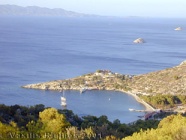
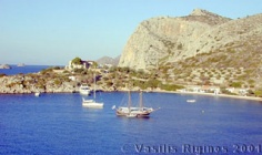
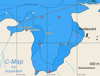
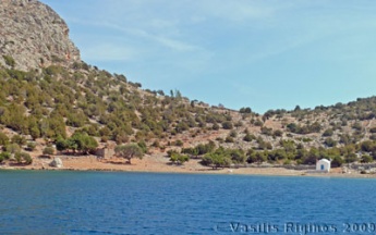
The isolated island of Dokos or Dhokos (Δοκός) has several anchorages. During the day, especially in the weekends, there are many boats here but in the evening it is very quiet. There is only one family on the island who runs a rather indifferent but expensive restaurant. They do monitor VHF channel 16. | The isolated island of Dokos or Dhokos (Δοκός) has several anchorages. During the day, especially in the weekends, there are many boats here but in the evening it is very quiet. There is only one family on the island who runs a rather indifferent but expensive restaurant. They do monitor VHF channel 16. | ||
| + | {{Image right|Greece_Dokos.jpg |The anchorage in Dokos - ''Click for larger view'' }} | ||
The NE cove is fairly deep, about 20 m, and hard to anchor. Here an ancient shipwreck has been found and explored. While snorkeling, however, I have not been able to see anything. The other anchoring opportunities, 3-6 m are easier although holding is not always good. | The NE cove is fairly deep, about 20 m, and hard to anchor. Here an ancient shipwreck has been found and explored. While snorkeling, however, I have not been able to see anything. The other anchoring opportunities, 3-6 m are easier although holding is not always good. | ||
| Line 133: | Line 126: | ||
=====Last Visited & Details Checked (and updated here)===== | =====Last Visited & Details Checked (and updated here)===== | ||
''Date of member's visit to this Port/Stop & this page's details validated'': | ''Date of member's visit to this Port/Stop & this page's details validated'': | ||
| - | * September 2007 | + | * September 2007 {{Istioploos2}} |
* | * | ||
| Line 150: | Line 143: | ||
; Electricity | ; Electricity | ||
: N/A | : N/A | ||
| + | {{hold vertical}} | ||
==Things to do Ashore== | ==Things to do Ashore== | ||
| Line 193: | Line 187: | ||
==External Links== | ==External Links== | ||
* [http://en.wikipedia.org/wiki/Hydra%2C_Saronic_Islands Hydra] (Wikipedia) | * [http://en.wikipedia.org/wiki/Hydra%2C_Saronic_Islands Hydra] (Wikipedia) | ||
| - | * [http://www.hydradirect.com Hydra Direct | + | * [http://www.hydradirect.com Hydra Direct] |
* | * | ||
| Line 207: | Line 201: | ||
| - | {{ | + | {{Page useable}} |
| - | + | {{Contributors|[[User:Istioploos|Istioploos]], [[User:atheneoflymington|Athene of Lymington]], [[User:Maelms|Maelms]]}} | |
| - | { | + | |
| - | + | ||
| - | | | + | |
| - | + | ||
| - | + | ||
| - | + | ||
| - | + | ||
| - | + | {{Navbar| [[Mediterranean]] | [[Aegean Sea]] | [[Greece]] | [[Saronikos Gulf]] | [[East Peloponnese]] | [[Hydra]] }} | |
| - | { | + | |
| - | + | ||
| - | + | ||
| - | + | ||
| - | + | ||
[[Category:Islands - Greece]][[Category:Ports - Greece]] [[Category:Anchorages - Greece]] | [[Category:Islands - Greece]][[Category:Ports - Greece]] [[Category:Anchorages - Greece]] | ||
Revision as of 20:21, 30 April 2015
| Hydra
| |
Hydra or Idhra (Ύδρα) is a very popular and picturesque island on the NW of Peloponnese.
Hydra as well as with Spetses and Psara were the most important Greek sea powers during the 1821 revolution which resulted in Greece's independence from the Ottoman rule. Hydra not only had the largest fleet of sailing vessels but was the home of Admiral Miaoulis and many other important captains.
Hydra is a barren island and in antiquity was not very important. It was purchased in the 6th century BC by the famous Tyrant of Samos, Polykcrates but was not settled until the 15th century AD when Greek and Albanians fleeing the tyranny of Ali Pasha of Epirus moved in the island. Since there were hardly any resources for significant cultivation, they turned to the sea for trade, smuggling and piracy. By the 18th century the island had a fleet of 150 vessels and a wealthy population of 25,000. During the war of independence they were so successful that Ibrahim Pasha of Egypt called Hydra "Little England."
After the revolution, with the establishment of the Greek state, piracy was suppressed. This combined with the advent of steamships resulted in a decline of Hydra. Its inhabitants turned to sea again mostly sponge fishing but again the combination of a sponge disease and declining markets further depressed the island's economy. In the 1950's Hydra was the location of the film Boy on a Dolphin with Sofia Loren. Following this film the island was "discovered" and an artist colony was established spearheaded by the very successful Greek painter Hadjikyriakos Ghikas. Artists flocked here from all over the world and bought houses and Hydra became as famous as St. Tropez and Portofino. There are no roads and no cars in Hydra and that has saved the island. Despite its fame, it is still a very attractive place.
Charts
- BA
- 1031 Yerakas to Kea
- Imray-Tetra
- G14 Saronic and Argolic Gulfs
- NIMA
- 54340 Nisos Spetsai - N. Vorioi Sporadhes
- Greek
- 415 Ydra to Sikinos
Radio Nets
- Coast Guard - Channel 12
Also see World Cruiser's Nets
Weather
See Aegean Sea.
The approaches to Hydra present no problems other then the heavy and at times chaotic traffic to and from the harbor to the mainland.
Berthing Options
Ports
Hydra Harbor
| Hydra Harbor
| |
The harbor of Hydra is always very crowded in high season and is best avoided at that time. Early spring is the best time to visit, when it is usually possible to moor either on the south quay or the inside of the north breakwater (where, however, it shallows as you go further in). In peak season, it is not unusual for boats to be moored three deep on the quay.
Crossed anchors is the least of the problems here. A bad swell develops with strong N-NW winds. It is better to anchor in near-by Mandraki or Vikhos.
Warning: There are several rocks near the N breakwater.
One time I was moored here a fishing caïque, returning in the middle of the night, untied my stern lines and my boat was nearly damaged. --Istioploos
Last Visited & Details Checked (and updated here)
Date of member's visit to this Port/Stop & this page's details validated:
- September 2001 --Istioploos

 Travels with S/Y Thetis
- May 2006 --Athene of Lymington
- September 2013 --Maelms

 Vi Seiler
Marinas & Yacht Clubs
None.
Anchorages
Mandraki
Warning: The water taxis create a strong wake as the zoom by.
Last Visited & Details Checked (and updated here)
Date of member's visit to this Port/Stop & this page's details validated:
- 1989 --Istioploos

 Travels with S/Y Thetis
- July 2013 --Maelms

 Vi Seiler
Vikhos
Warning: The water taxis create a strong wake as the zoom by.
Last Visited & Details Checked (and updated here)
Date of member's visit to this Port/Stop & this page's details validated:
- September 2001 --Istioploos

Molos
Last Visited & Details Checked (and updated here)
Date of member's visit to this Port/Stop & this page's details validated:
- September 2007 --Istioploos

 Travels with S/Y Thetis
Bitsi
Ayios Nikolaos
Offshore Islands
Dokos
| Dokos
| |
The isolated island of Dokos or Dhokos (Δοκός) has several anchorages. During the day, especially in the weekends, there are many boats here but in the evening it is very quiet. There is only one family on the island who runs a rather indifferent but expensive restaurant. They do monitor VHF channel 16.
The NE cove is fairly deep, about 20 m, and hard to anchor. Here an ancient shipwreck has been found and explored. While snorkeling, however, I have not been able to see anything. The other anchoring opportunities, 3-6 m are easier although holding is not always good.
Last Visited & Details Checked (and updated here)
Date of member's visit to this Port/Stop & this page's details validated:
- September 2007 --Istioploos

 Travels with S/Y Thetis
Yacht Services and Repairs
Marine Stores
Only fishing materials.
Yacht Services/Repairs/Yards
None.
Fuel, Water, & Electricity
- Fuel
- N/A (Not Available)
- Water
- On the quay in Hydra Harbor
- Electricity
- N/A
Things to do Ashore
Tourism
The town of Hydra is very picturesque and there no cars. The Nautical Museum is interesting with many exhibits relating to the island.
Grocery & Supply Stores
Stores in Hydra Harbor.
Eateries
- Good food at in Hydra Harbor and Vikhos.
- There is a restaurant in Dokos (VHF channel 16) but the food is mediocre and the prices very inflated
Internet/WiFi
In Internet cafés.
Laundry
- ?
Motorbike & Car Rentals
N/A.
Garbage Disposal
There are bins around the harbors and in several anchorages.
Transportation
- There are daily, and in the summer several per day, hydrofoils and ferries to Athens
- Water taxis run between Ermioni and several places in Hydra
Routes/Passages To/From
Cruiser's Friends
Contact details of "Cruiser's Friends" that can be contacted for local information or assistance.
Forum Discussions
List links to discussion threads on partnering forums. (see link for requirements)
External Links
- Hydra (Wikipedia)
- Hydra Direct
References & Publications
See Greece.
Personal Notes
Personal experiences?
Last Visited & Details Checked (and updated here)
See individual ports, anchorages, and islands in this page.
| This is a usable page of the cruising guide. However, please contribute if you can to help it grow further. Click on Comments to add your personal notes on this page or to discuss its contents. Alternatively, if you feel confident to edit the page, click on the edit tab at the top and enter your changes directly. |
| |
|---|
|
Names: Istioploos, Athene of Lymington, Maelms |
| Cruising Wiki Navigation
|
|---|
| | HOMEPAGE | Wiki Contents | Mediterranean | Aegean Sea | Greece | Saronikos Gulf | East Peloponnese | Hydra | |
