Kos
From CruisersWiki
Istioploos (Talk | contribs) (Added Category) |
|||
| (42 intermediate revisions not shown) | |||
| Line 1: | Line 1: | ||
| - | + | {{IsPartOf|Mediterranean|Aegean Sea|Greece|Dodecanese}} | |
| - | { | + | {{TOC block}} |
| - | + | ||
| - | + | ||
| - | | | + | |
| - | + | ||
| - | | | + | |
| - | + | ||
| - | + | ||
| - | + | ||
| - | + | ||
| - | + | ||
| - | + | ||
| - | + | ||
| - | [http://en.wikipedia.org/wiki/Kos Kos] (Κώς) is a fairly large and elongated island of the [http://en.wikipedia.org/wiki/Dodecanese Dodecanese] group, with an area of 290 km<sup>2</sup>. Its highest peak is 845 m (2772 ft) located on its NE end | + | {{infobox | lat=36.80783|lon=27.14517 |
| - | + | | zoom= 10 | |
| - | + | | chartlet= y | |
| + | | containsportofentry= y | ||
| + | | image= Greece_Kos_S.jpg | ||
| + | | imagetext= Satellite view of Kos | ||
| + | }} | ||
| + | [http://en.wikipedia.org/wiki/Kos Kos] (Κώς) is a fairly large and elongated island of the [http://en.wikipedia.org/wiki/Dodecanese Dodecanese] group, with an area of 290 km<sup>2</sup>. Its highest peak is 845 m (2772 ft) located on its NE end. | ||
Unfortunately, this nice island has been overrun by tourists, it is extremely noisy and very mercenary. | Unfortunately, this nice island has been overrun by tourists, it is extremely noisy and very mercenary. | ||
==Charts== | ==Charts== | ||
| - | + | ; BA | |
| + | : 872 Kalimno to Rhodes, including the Gulfs of Kos, Doris, and Symi | ||
| + | : 1604 Gulf of Kos, Doris and Simi | ||
| + | ; Imray-Tetra | ||
| + | : G35 Dodecanese and the Coast of Turkey | ||
| + | ; NIMA | ||
| + | : 54407 Nisos Kalymnos to Kadriga Burnu | ||
| + | : 54408 NIsos Kos To Nisos Tilos | ||
| + | : NIMA 54413 Nisos Kalimnos & Nisos Kos (Western Part) | ||
| + | ; Greek | ||
| + | : 451 Leros to Rhodos | ||
| + | |||
| + | ==Weather== | ||
| + | ''See [[Aegean_Sea#Weather|Aegean Sea]]''. | ||
| + | |||
| + | ==Passages== | ||
| + | * [[N - S Passages in East Aegean]] | ||
| + | * [[Cruising the Dodecanese Islands]] | ||
| - | + | ==Islands== | |
| - | + | * {{dest|Pserimos |a}} | |
| - | + | * {{dest|Yiali |a}} | |
| - | + | * {{dest|Niseros |h|a}} | |
| - | + | ||
| - | + | ||
| - | + | ||
| - | + | ||
| - | + | ||
| - | + | ||
| - | + | ||
| - | == | + | ==Communication== |
| - | + | ||
* Coast Guard - VHF channel 12 & Tel. +30 2420 28 507 | * Coast Guard - VHF channel 12 & Tel. +30 2420 28 507 | ||
* Olympia Radio - VHF channels 01 and 63 (on the N side of the island) | * Olympia Radio - VHF channels 01 and 63 (on the N side of the island) | ||
| - | + | ''Also see [[HF_Radio|Cruiser's Nets]]'' | |
| - | '' | + | |
| + | ==Navigation== | ||
| + | {{Warning}}There are dangerous shoals N of Cape Kum and the sea can be very confused around the cape. Also, with a B ''meltemi'' there are very violent gusts near the SE shore of the island. Maintain a good distance off-shore. | ||
| - | + | {{image right|Greece_KosKrikelo.jpg |Approaching Cape Krikelo }} | |
| - | + | ||
| - | == | + | ==Entrance== |
| - | + | [[#Kos Harbor|Kos Harbor]] is a Greek port of entry/exit. You can clear formalities at either [[#Kos Harbor|Kos Harbor]] or at [[Kos Marina]]. | |
| + | {{hold vertical}} | ||
| - | == | + | ==Berthing== |
===Ports=== | ===Ports=== | ||
| - | = | + | {{Poi |36|53.75|N|27|17.29|E| | type= harbour |name= Kos Harbor |altname= Κώς |zoom= 16 |
| - | + | | image= Greece_Kos_h.jpg | imagetext= Chart of Kos harbor | |
| - | + | | portofentry= y | |
| - | Kos is the main harbor on the island. It is a large and safe harbor although it is subject to N-NE winds which can cause considerable swell within the large harbor. | + | | text= Kos is the main harbor on the island. It is a large and safe harbor although it is subject to N-NE winds which can cause considerable swell within the large harbor. As an alternative a yacht can go the near by [[Kos Marina]]. |
| - | In the last few years the harbor has been changed with new extensions. Now yachts can moor on either the E side of the harbor under the castle or on the NE side, outside the harbour, when the weather is settled. The S side where yachts used to anchor is now reserved for the many day-trip caïques. | + | In the last few years the harbor has been changed with new extensions. Now yachts can moor on either the E side of the harbor under the castle or on the NE side, outside the harbour, when the weather is settled. The S side where yachts used to anchor is now reserved for the many day-trip caïques. The berths are managed by Kos Marina. Speak with the dockmaster on CH74 and you will be directed to a berth. Expect the harbor to be crowded during the summer months. Anchor in about 5 m depths and go stern-to to the quay. Depths at your stern will be 2 m except at the extreme northern end. Excellent holding on mud. |
| - | The quay under the castle now has water and electricity outlets, although these are only available during peak season ( | + | The quay under the castle now has water and electricity outlets, although these are only available during peak season (May - September) when the quay is manned and a charge is made. Outside those months mooring is free but there are no facilities. Many supplies can be obtained in the town, but due to the extremely large number of tourists the town has lost its soul.}} |
| - | + | {{hgallery| | |
| - | + | {{himage|Greece_Kos1.jpg|Kos harbor}} | |
| - | + | {{himage|Kos.jpeg|Caique in Kos harbour}} | |
| - | + | }} | |
| - | ==== | + | {| class="infobox bordered" style="width: 28em; text-align: right; font-size: 90%;" |
| - | [[Image:Greece_Kos_Mastichari_h.jpg| | + | |- |
| - | + | | colspan="2" style="text-align:center;" | [[Image:Greece_Kos_Mastichari_h.jpg|352px]]Chart of Mastichari | |
| - | Mastichari is small fishing village on the NW coast. | + | |} |
| + | {{Poi |36|51.1|N|27|04.7|E| | type= harbour |name= Mastichari |altname= Μαστιχάρι |zoom= 16 | ||
| + | | text= Mastichari is small fishing village on the NW coast. | ||
| - | + | It is possible to stay overnight longside at the outer end of the north-east mole, with depth 3 meters. You have to leave before 7 a.m. when the ferry from Kalymnos arrives.}} | |
| - | + | {{hold vertical}} | |
| - | + | ||
| - | + | ||
| - | + | ||
| - | + | {{Poi |36|47|N|27|08.8|E| | type= harbour |name= Kardamena |altname= Καρδάμαινα |zoom= 16 | |
| + | | image= Kardamena Chart.jpg | imagetext= Chart of Kardamena | ||
| + | | text= Kardamaina, is a small town 7 km from Kos Island International Airport at Antimacheia, situated mid-way along the south coast of the island of Kos. It has the reputation as the most picturesque village in the island. | ||
| - | + | The harbour is modernised and good for 10 to 12 guest yachts, along the north quay. 2 or 3 yachts can go longside at the south mole, for short over night stay. Depth is 3 to 2 meters. Electricity and water ist available. | |
| - | + | ||
| - | + | ||
| - | + | Between June and September the town population may triple due to tourist influx. Beautifull promenade along the harbour. Lots of tourists-shops, discos, bistros and restaurants. | |
| - | + | ''Captain's Restaurant'' on harbour front, west of harbour police, best fish restaurant, but also menu from lamb chops up to Chateaubriand at reasonable prices, excellent quality and service. }} | |
| - | === | + | {{hgallery| |
| - | + | {{himage|Kardamena W.jpg| Kardamena West}} | |
| - | + | {{himage|Kardamena E.jpg| Kardamena East}} | |
| - | + | }} | |
| - | + | ||
| + | {{Poi |36|44.2|N|26|58.37|E| | type= harbour |name= Kamares Bay |altname= Καμάρες |zoom= 17 | ||
| + | | image= Greece_Kos_Kamares_h.jpg | imagetext= Chart of Kamares | ||
| + | | text= Kamares or Kamari is a small and fairly attractive harbor on the S end of the island. It offers good shelter from the ''meltemi''. | ||
| + | |||
| + | You can go to the quay side-to, if there is room, or stern to. Alternatively you can anchor N of the quay in 5 m. It does get deep very fast. There are a few tavernas and several large hotels within sight. It can get rather noisy at night. }} | ||
===Marinas & Yacht Clubs=== | ===Marinas & Yacht Clubs=== | ||
* [[Kos Marina]] | * [[Kos Marina]] | ||
| - | == | + | ==Anchorages== |
| - | + | {{Green|List details of all safe anchorages in the area.}} | |
| - | + | * | |
| + | * | ||
| + | * | ||
| - | == | + | ==Amenities== |
| - | + | {{tlist | |
| - | + | |header|Facilities | |
| - | + | ||
| - | + | ||
| - | + | ||
| - | + | ||
| - | + | ||
| - | + | ||
| - | + | ||
| - | + | |Water| | |
| - | * [[ | + | * [[Kos Marina]]: tel. {{phone|30|2242|057500}} |
| - | * [[ | + | * [[#Kos Harbor|Kos Harbor]]: outlets on the quay |
| - | * [[ | + | * [[#Kardamena|Kardamena]]: outlets on the quay |
| - | + | |Electricity| [[Kos Marina]]: tel. {{phone|30|2242|057500}} | |
| - | + | |Toilets| In [[Kos Marina]] | |
| - | [[ | + | |Showers| In [[Kos Marina]] |
| + | |Laundry| In [[Kos Marina]] and in town, +30 2242 022438 Zervanou street (will collect & deliver) | ||
| + | |Garbage| There are bins in many places (harbors & marina) | ||
| - | + | |header|Supplies | |
| + | |Fuel| [[Kos Marina]]: fuel station outside the marina, tel. {{phone|30|2242|057500}} | ||
| + | |Bottled gas| In grocery stores | ||
| + | |Chandlers| [[Kos Marina]]: good store in the marina, tel. {{phone|30|2242|057500}} | ||
| - | + | |header|Services | |
| + | |Repairs| [[Kos Marina]]: some repairs in the marina, tel. {{phone|30|2242|057500}} | ||
| + | |Internet| In Internet cafés in the towns and the marina (marina charges €3.0 per day, code for 2 users) | ||
| + | |Mobile connectivity| good 3G and in places 4G signal | ||
| + | |Vehicle rentals| In the town | ||
| + | }} | ||
| - | == | + | ==Provisioning== |
| - | Supermarkets in the town and in the [[Kos_Marina|marina]] | + | Supermarkets in the town and in the [[Kos_Marina|marina]]. |
| - | == | + | ==Eating out== |
* In general, food in Kos is very bad and overpriced | * In general, food in Kos is very bad and overpriced | ||
* The restaurant in the [[Kos_Marina|marina]] is surprisingly reasonable | * The restaurant in the [[Kos_Marina|marina]] is surprisingly reasonable | ||
| + | * ''Taverna Alexandros'' in Old Town is quite good and reasonable. | ||
| - | == | + | ==Transportation== |
| - | + | There are daily flights to Athens, ferries, and hydrofoils to other islands. | |
| - | === | + | ==Tourism== |
| - | In the [[ | + | ====History==== |
| + | {{image right|Greece_Kos2.jpg |The Aesclepion }} | ||
| + | In antiquity Kos was famous as the birthplace of [http://en.wikipedia.org/wiki/Hippocrates Hippocrates], the father of medicine. Near the town (about 5 km) there are the substantial ruins of the [http://odysseus.culture.gr/h/3/eh351.jsp?obj_id=2395 Aesclepion] where the ancient god of medicine [http://www.maicar.com/GML/Asclepius.html Aeslepios], the son of [http://www.maicar.com/GML/Apollo.html Apollo], was worshipped. | ||
| - | + | The modern town is dominated by the castle built by the [http://en.wikipedia.org/wiki/Knights_Hospitaller Knights of Rhodes] after the crusades. Later, in 1523 it was taken from the Knights of Rhodes by the [http://en.wikipedia.org/wiki/Ottoman_Empire Ottomans] who held the island until 1912 when Kos with the rest of the Dodechanese were taken over by the Italians who held it until 1948, after [http://en.wikipedia.org/wiki/World_War_II WW II], when it became part of Greece. | |
| - | + | ||
| - | === | + | ====Places to Visit==== |
| - | + | The most important site on the island is the [http://en.wikipedia.org/wiki/Asclepieion Aesclepion], one of the most important temples of the ancient world. It is situated about 5 km from the town of Kos. One can easily spent a whole morning exploring the ruins of the various buildings. | |
| - | = | + | In town is worth visiting the [http://www.frommers.com/destinations/kos/A28251.html Archaeological Museum], [http://www.travel-to-kos.com/page.php?page_id=49 Kasa Romana,] a Roman villa, and the [http://www.travel-to-kos.com/place.php?place_id=8 Neratzia Castle] of the [http://en.wikipedia.org/wiki/Knights_Hospitaller Knights of Rhodes]. |
| - | + | ||
| - | == | + | ==Friends== |
Contact details of "Cruiser's Friends" that can be contacted for local information or assistance. | Contact details of "Cruiser's Friends" that can be contacted for local information or assistance. | ||
| - | == | + | ==Forums== |
| - | List links to discussion threads on [[Cruising Forums|partnering forums]]. (see link for requirements) | + | List links to discussion threads on [[Cruising Forums|partnering forums]]. (''see link for requirements'') |
* | * | ||
* | * | ||
* | * | ||
| - | == | + | ==Links== |
| - | * | + | * {{wikipedia}} |
| + | * {{Wikivoyage}} | ||
| + | * | ||
| + | |||
| + | ==References== | ||
| + | ''See [[Greece#References_&_Publications|Greece]]''. | ||
| + | |||
| + | {{Comments}} | ||
* | * | ||
* | * | ||
| - | |||
| - | |||
| - | + | {{Verified by}} | |
''Date of member's visit to this marina & this page's details validated'': | ''Date of member's visit to this marina & this page's details validated'': | ||
| - | |||
* June 2007 -- [[User:atheneoflymington|Athene of Lymington]] | * June 2007 -- [[User:atheneoflymington|Athene of Lymington]] | ||
| + | * May 2012 --[[User:Blome|Blome]] | ||
| + | * June 2012 {{Istioploos2}} | ||
| + | * May 2014 --[[User:Monterey|Monterey]][[Image:Bermuda Icon.png]] | ||
| + | * June 2019 ([[#Kos Harbor|Kos Harbor]]) --[[User:Io|Io]] | ||
| + | * August 2020 ([[# Kamares Bay|Kamares Bay]]) --[[User:Io|Io]] | ||
| - | |||
| - | |||
| - | |||
| + | {{Page useable}} | ||
| - | |||
| - | |||
| - | |||
| - | |||
| - | |||
| - | |||
| - | |||
| - | |||
| - | |||
| - | |||
| - | |||
| - | |||
| - | |||
| - | |||
| - | |||
| - | |||
| - | |||
| - | |||
| - | |||
| + | {{Contributors|[[User:Lighthouse|Lighthouse]], [[User:Istioploos|Istioploos]], [[User:atheneoflymington|Athene of Lymington]], [[User:Blome|Blome]]}} | ||
| - | [[Category:Islands | + | [[Category:Islands - Greece]] |
Latest revision as of 13:07, 9 September 2020
| Kos There are Port(s) of Entry here
| |
| | |
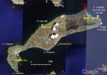
Kos (Κώς) is a fairly large and elongated island of the Dodecanese group, with an area of 290 km2. Its highest peak is 845 m (2772 ft) located on its NE end.
Unfortunately, this nice island has been overrun by tourists, it is extremely noisy and very mercenary.
Charts
- BA
- 872 Kalimno to Rhodes, including the Gulfs of Kos, Doris, and Symi
- 1604 Gulf of Kos, Doris and Simi
- Imray-Tetra
- G35 Dodecanese and the Coast of Turkey
- NIMA
- 54407 Nisos Kalymnos to Kadriga Burnu
- 54408 NIsos Kos To Nisos Tilos
- NIMA 54413 Nisos Kalimnos & Nisos Kos (Western Part)
- Greek
- 451 Leros to Rhodos
Weather
See Aegean Sea.
Passages
Islands
Communication
- Coast Guard - VHF channel 12 & Tel. +30 2420 28 507
- Olympia Radio - VHF channels 01 and 63 (on the N side of the island)
Also see Cruiser's Nets
Warning: There are dangerous shoals N of Cape Kum and the sea can be very confused around the cape. Also, with a B meltemi there are very violent gusts near the SE shore of the island. Maintain a good distance off-shore.
Entrance
Kos Harbor is a Greek port of entry/exit. You can clear formalities at either Kos Harbor or at Kos Marina.
Berthing
Ports
Kos Harbor
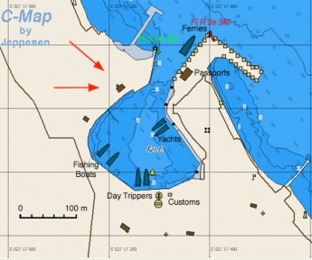
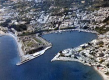
Kos is the main harbor on the island. It is a large and safe harbor although it is subject to N-NE winds which can cause considerable swell within the large harbor. As an alternative a yacht can go the near by Kos Marina.
In the last few years the harbor has been changed with new extensions. Now yachts can moor on either the E side of the harbor under the castle or on the NE side, outside the harbour, when the weather is settled. The S side where yachts used to anchor is now reserved for the many day-trip caïques. The berths are managed by Kos Marina. Speak with the dockmaster on CH74 and you will be directed to a berth. Expect the harbor to be crowded during the summer months. Anchor in about 5 m depths and go stern-to to the quay. Depths at your stern will be 2 m except at the extreme northern end. Excellent holding on mud.
The quay under the castle now has water and electricity outlets, although these are only available during peak season (May - September) when the quay is manned and a charge is made. Outside those months mooring is free but there are no facilities. Many supplies can be obtained in the town, but due to the extremely large number of tourists the town has lost its soul. 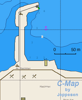 Chart of Mastichari Chart of Mastichari
|
Mastichari
Mastichari is small fishing village on the NW coast.
It is possible to stay overnight longside at the outer end of the north-east mole, with depth 3 meters. You have to leave before 7 a.m. when the ferry from Kalymnos arrives.Kardamena
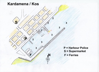
Kardamaina, is a small town 7 km from Kos Island International Airport at Antimacheia, situated mid-way along the south coast of the island of Kos. It has the reputation as the most picturesque village in the island.
The harbour is modernised and good for 10 to 12 guest yachts, along the north quay. 2 or 3 yachts can go longside at the south mole, for short over night stay. Depth is 3 to 2 meters. Electricity and water ist available.
Between June and September the town population may triple due to tourist influx. Beautifull promenade along the harbour. Lots of tourists-shops, discos, bistros and restaurants.
Captain's Restaurant on harbour front, west of harbour police, best fish restaurant, but also menu from lamb chops up to Chateaubriand at reasonable prices, excellent quality and service.Kamares Bay
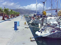
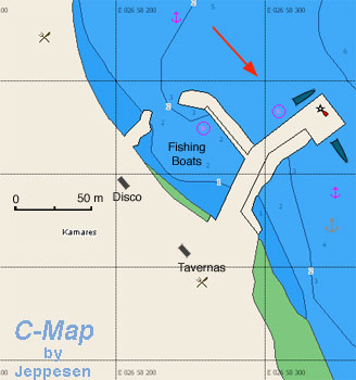
Kamares or Kamari is a small and fairly attractive harbor on the S end of the island. It offers good shelter from the meltemi.
You can go to the quay side-to, if there is room, or stern to. Alternatively you can anchor N of the quay in 5 m. It does get deep very fast. There are a few tavernas and several large hotels within sight. It can get rather noisy at night.Marinas & Yacht Clubs
Anchorages
List details of all safe anchorages in the area.
Amenities
| Facilities | |
|---|---|
| Water |
|
| Electricity | Kos Marina: tel. +30 (2242) 057500 |
| Toilets | In Kos Marina |
| Showers | In Kos Marina |
| Laundry | In Kos Marina and in town, +30 2242 022438 Zervanou street (will collect & deliver) |
| Garbage | There are bins in many places (harbors & marina) |
| Supplies | |
| Fuel | Kos Marina: fuel station outside the marina, tel. +30 (2242) 057500 |
| Bottled gas | In grocery stores |
| Chandlers | Kos Marina: good store in the marina, tel. +30 (2242) 057500 |
| Services | |
| Repairs | Kos Marina: some repairs in the marina, tel. +30 (2242) 057500 |
| Internet | In Internet cafés in the towns and the marina (marina charges €3.0 per day, code for 2 users) |
| Mobile connectivity | good 3G and in places 4G signal |
| Vehicle rentals | In the town |
Provisioning
Supermarkets in the town and in the marina.
Eating out
- In general, food in Kos is very bad and overpriced
- The restaurant in the marina is surprisingly reasonable
- Taverna Alexandros in Old Town is quite good and reasonable.
Transportation
There are daily flights to Athens, ferries, and hydrofoils to other islands.
Tourism
History
In antiquity Kos was famous as the birthplace of Hippocrates, the father of medicine. Near the town (about 5 km) there are the substantial ruins of the Aesclepion where the ancient god of medicine Aeslepios, the son of Apollo, was worshipped.
The modern town is dominated by the castle built by the Knights of Rhodes after the crusades. Later, in 1523 it was taken from the Knights of Rhodes by the Ottomans who held the island until 1912 when Kos with the rest of the Dodechanese were taken over by the Italians who held it until 1948, after WW II, when it became part of Greece.
Places to Visit
The most important site on the island is the Aesclepion, one of the most important temples of the ancient world. It is situated about 5 km from the town of Kos. One can easily spent a whole morning exploring the ruins of the various buildings.
In town is worth visiting the Archaeological Museum, Kasa Romana, a Roman villa, and the Neratzia Castle of the Knights of Rhodes.
Friends
Contact details of "Cruiser's Friends" that can be contacted for local information or assistance.
Forums
List links to discussion threads on partnering forums. (see link for requirements)
Links
References
See Greece.
Comments
We welcome users' contributions to the Wiki. Please click on Comments to view other users' comments, add your own personal experiences or recommend any changes to this page following your visit.
Verified by
Date of member's last visit to Kos and this page's details validated: Date of member's visit to this marina & this page's details validated:
- June 2007 -- Athene of Lymington
- May 2012 --Blome
- June 2012 --Istioploos

 Travels with S/Y Thetis
- May 2014 --Monterey

- June 2019 (Kos Harbor) --Io
- August 2020 (Kamares Bay) --Io
| This is a usable page of the cruising guide. However, please contribute if you can to help it grow further. Click on Comments to add your personal notes on this page or to discuss its contents. Alternatively, if you feel confident to edit the page, click on the edit tab at the top and enter your changes directly. |
| |
|---|
|
Names: Lighthouse, Istioploos, Athene of Lymington, Blome |
