Marmara Islands
From CruisersWiki
Lighthouse (Talk | contribs) m (Text replace - "Mediterranean" to "Mediterranean") |
Istioploos (Talk | contribs) m (Moved Table of Contents) |
||
| Line 1: | Line 1: | ||
==Marmara Islands== | ==Marmara Islands== | ||
| - | {| class="infobox bordered" style="width: | + | {| class="infobox bordered" style="width: 33em; text-align: left; font-size: 85%;" |
|- | |- | ||
| - | | colspan="2" style="text-align: | + | | colspan="2" style="text-align:center; font-size: smaller;" | {{Small info}} (''Click links for more information'') |
|- | |- | ||
| - | ! | + | ! <center>[[image:World_icon.png]]</center> |
| {{Coord|40|35|N|27|33.6|E|}} | | {{Coord|40|35|N|27|33.6|E|}} | ||
|- | |- | ||
| - | ! | + | ! <center>[[image:Photo_icon.png]]</center> |
| [http://www.panoramio.com/map/#lt=40.565459&ln=27.645721&z=6&k=0&a=1&tab=2 Photo gallery] | | [http://www.panoramio.com/map/#lt=40.565459&ln=27.645721&z=6&k=0&a=1&tab=2 Photo gallery] | ||
|- | |- | ||
| - | ! | + | ! <center>[[image:Chart_icon.png]]</center> |
| [http://mapserver.mytopo.com/homepage/index.cfm?lat=40.583333&lon=27.56&scale=750000&zoom=100&type=0&icon=0&searchscope=dom&CFID=17583484&CFTOKEN=79232580&scriptfile=http://mapserver.mytopo.com/homepage/index.cfm&latlontype=DMS Local chartlet] | | [http://mapserver.mytopo.com/homepage/index.cfm?lat=40.583333&lon=27.56&scale=750000&zoom=100&type=0&icon=0&searchscope=dom&CFID=17583484&CFTOKEN=79232580&scriptfile=http://mapserver.mytopo.com/homepage/index.cfm&latlontype=DMS Local chartlet] | ||
|} | |} | ||
| Line 33: | Line 33: | ||
Submit details of local radio Nets. | Submit details of local radio Nets. | ||
| - | + | {{TOCleft}} | |
==Approach and Navigation== | ==Approach and Navigation== | ||
<font color="red">Warning:</font> While the approaches the islands is straightforward but when nearing an anchorage care should be exercised, especially at night, as there are many reefs. | <font color="red">Warning:</font> While the approaches the islands is straightforward but when nearing an anchorage care should be exercised, especially at night, as there are many reefs. | ||
Revision as of 21:05, 15 February 2011
Marmara Islands
| | |
| | 40°35′N, 27°33.6′E |
|---|---|
| | Photo gallery |
| | Local chartlet |
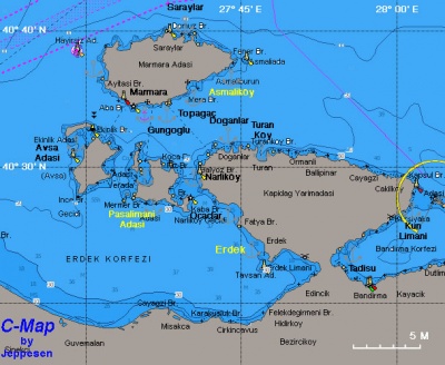
This is a group of islands in the middle of the Sea of Marmara. The largest is Marmara Adasi (Προκόνησος- Prokonnisos) the largest island in the Sea of Marmara. Its peak is 720 m above sea level. Its south side is very wooded and green while its north side is very heavily quarried for marble. The marble (Greek Μάρμαρο -Marmaro) not only gives the name of the island but to the whole gulf: Marmara Sea.
The other islands of this group are: Pasalimani Adasi, and Avsa Adasi.
Charts
- Turkey
- 296 Marmara Adaları
- 2942 Ports in Marmara Denizi - A Marmara Adası
- 2941 Ports in Marmara Denizi - D Saraylar
See also Marmara Sea.
Radio Nets
Also see Cruiser's Nets
Submit details of local radio Nets.
Warning: While the approaches the islands is straightforward but when nearing an anchorage care should be exercised, especially at night, as there are many reefs.
Ports and Popular Stops
Port Marmara
GPS: 40°35′N, 27°33.6′E
Port Marmara is the main harbor in Marmara Adasi.
(Need more info here).
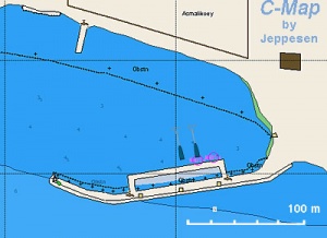
Asmaliköy
GPS: 40°36.9′N, 27°42.4′E
Asmaliköy (Greek Αφθόνη - Afthoni) is a small harbor on the E side of Marmara Adasi. Asmaliköy is very attractive, totally untouched by the outside world despite its relative proximity to Istanbul. It has a few houses, some very attractive made of wood. There is only one çay hani (tea house) and a most rudimentary store.
Go stern-to the quay. It gets shallow very quickly so, it best to proceed very carefully and keep a distance between the stern and the quay.
Saraylar
GPS: 40°39.5′N, 27°39.9′E
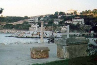
Saraylar (Παλάτια - Palatia) is the port from where the marble is loaded. The harbor is totally built of marble blocks and it is decorated by ancient column segments and other architectural fragments--all of the marble rejects of ancient craftsmen.
Anchorages
Pasalimani Adasi
GPS: 40°27.5′N, 27°35.6′E - Chartlet
There is a nice cove on the S side of the island.
Routes/Passages To/From
Popular passages/routes, timing, etc.
Tourism & things to do ashore
If you can arrange land transportation, a visit to Saraylar (Παλάτια - Palatia) is worth your time. The dirt road is steep and winds through many sycamore trees and green vistas. Saraylar is the port from where the marble is loaded. It is an attractive town but it is surrounded by the moonscape of the marble quarries. The island has been quarried for marble since antiquity. The harbor is totally built of marble blocks and it is decorated by ancient column segments and other architectural fragments--all of the marble rejects of ancient craftsmen.
Fuel, Water, & Electricity
- Fuel - In Port Marmara
- Water - Only one water outlet in Port Marmara and Asmaliköy
- Electricity - N/A
Laundry
N/A.
Grocery & Supply Stores
- Some provisions in Port Marmara and Saraylar
- Only bread in Asmaliköy
Eateries
- Several restaurants in Port Marmara and Saraylar
- Only a çay hani in Asmaliköy
Internet/WiFi
N/A.
Motorbike & Car Rentals
N/A.
Marine Stores & Facilities
None.
Repairs
N/A.
Transportation
Ferries to Istanbul and Erdek.
References & Publications
See Turkey.
Cruiser's Friends
Contact details of "Cruiser's Friends" that can be contacted for local information or assistance.
Forum Discussions
List links to discussion threads on partnering forums. (see link for requirements)
External Links
- Marmara Adasi (Wikipedia)
Personal Notes
Personal experiences?
Last Visited & Details Checked (and updated here)
Date of member's visit to this Port/Stop & this page's details validated:
- July 1999 --Istioploos

| |
|---|
| | HOMEPAGE | Wiki Contents | Mediterranean | Turkey | Marmara Sea | Marmara Islands | |
.


