Mykonos
From CruisersWiki
m (bot: Berthing Options) |
m (Text replace - "==References & Publications==" to "==References==") |
||
| (11 intermediate revisions not shown) | |||
| Line 2: | Line 2: | ||
{{TOC block}} | {{TOC block}} | ||
{{Infobox |37|27|N|25|19.5|E| | {{Infobox |37|27|N|25|19.5|E| | ||
| - | | zoom= | + | | zoom= 11 |
| + | | chartlet = y | ||
| + | | containsportofentry= y | ||
| image= Greece_Myconos_m.jpg | | image= Greece_Myconos_m.jpg | ||
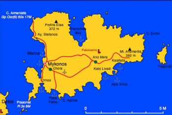
| imagetext= Map of Mykonos | | imagetext= Map of Mykonos | ||
| Line 9: | Line 11: | ||
Visiting yachts normally berth at the uncompleted [[Mykonos Marina]] two miles W of the main town, which is the only safe harbour on the island. Since its partial completion, yachts are no longer permitted to berth in Mykonos old harbour, which is reserved for tripper boats. | Visiting yachts normally berth at the uncompleted [[Mykonos Marina]] two miles W of the main town, which is the only safe harbour on the island. Since its partial completion, yachts are no longer permitted to berth in Mykonos old harbour, which is reserved for tripper boats. | ||
| - | |||
| - | |||
| - | |||
| - | |||
==Charts== | ==Charts== | ||
| Line 25: | Line 23: | ||
: Andros to Chalki Island | : Andros to Chalki Island | ||
: Karystos to Naxos | : Karystos to Naxos | ||
| - | |||
| - | |||
| - | |||
| - | |||
| - | |||
| - | |||
==Weather== | ==Weather== | ||
''See [[Aegean_Sea#Weather|Aegean Sea]]''. | ''See [[Aegean_Sea#Weather|Aegean Sea]]''. | ||
| + | |||
| + | ==Passages== | ||
| + | * [[Passages between Athens Region and Samos - Kusadasi]] | ||
| + | * [[Cruising the Cyclades Islands]] | ||
==Islands== | ==Islands== | ||
* [[Rhinia]] | * [[Rhinia]] | ||
* [[Rhinia#Delos|Delos]] | * [[Rhinia#Delos|Delos]] | ||
| + | |||
| + | ==Communication== | ||
| + | * Coast Guard - VHF channel 12 & Tel. +30 2890 23 922 | ||
| + | * Olympia Radio - VHF channel 03 & 04 | ||
| + | |||
| + | ''Also see [[World MM Nets|World Cruiser's Nets]]''. | ||
==Navigation== | ==Navigation== | ||
{{Warning}} The channel between Mykonos and [[Tinos]] has fierce gusts when the ''meltemi'' is blowing. | {{Warning}} The channel between Mykonos and [[Tinos]] has fierce gusts when the ''meltemi'' is blowing. | ||
| - | Berthing | + | ==Berthing== |
===Ports=== | ===Ports=== | ||
{{Poi |37|26.96|N|25|19.645|E| | type= harbour |name= Mykonos Harbour |altname= Μύκονος |zoom= 17 | {{Poi |37|26.96|N|25|19.645|E| | type= harbour |name= Mykonos Harbour |altname= Μύκονος |zoom= 17 | ||
| + | | portofentry= y | ||
| image= Greece_Myconos_h.jpg | | image= Greece_Myconos_h.jpg | ||
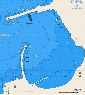
| imagetext= Chart of Mykonos Harbor | | imagetext= Chart of Mykonos Harbor | ||
| Line 51: | Line 54: | ||
The harbor is extremely crowded and noisy. It is sheltered from the ''meltemi'' but it has considerable swell which can be dangerous. If you must go and they let you go early. It is more quiet at the south-west jetty. | The harbor is extremely crowded and noisy. It is sheltered from the ''meltemi'' but it has considerable swell which can be dangerous. If you must go and they let you go early. It is more quiet at the south-west jetty. | ||
| - | + | In July 2017, the last berths without mooring lines now had those lines installed so anchoring is no longer required. Every berth now has a mooring line, with power and water also availavle everywhere. Prices are 5 to 8 euro for the mooring and 10 euro for the power and water, with a countdown meter taking money re the usage. You get back the difference if you don't use the full 10euro. We were on shore power for 3 days and took 250l of water and only spent 4 euro total. --[[User:Alfa1234|Alfa1234]] | |
| + | }} | ||
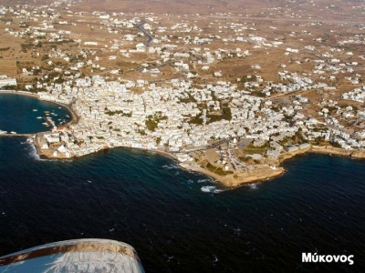
{{Image center|Greece_Mykonos_a.jpg |Aerial View of the Town & Harbor of Mykonos |400px}} | {{Image center|Greece_Mykonos_a.jpg |Aerial View of the Town & Harbor of Mykonos |400px}} | ||
| - | + | ||
{{Poi |37|27.9|N|25|19.5|E| | type= harbour | name= Tourlos | zoom= 16 | {{Poi |37|27.9|N|25|19.5|E| | type= harbour | name= Tourlos | zoom= 16 | ||
| text= The old Mykonos harbour is now closed for yachts. The new port is in an area called TOURLOS, which is about 1.5 km north of Mykonos town, but can be seen from town; it’s within walking distance but not if you are carrying luggage. See [[Mykonos Marina]] for details. }} | | text= The old Mykonos harbour is now closed for yachts. The new port is in an area called TOURLOS, which is about 1.5 km north of Mykonos town, but can be seen from town; it’s within walking distance but not if you are carrying luggage. See [[Mykonos Marina]] for details. }} | ||
| Line 61: | Line 65: | ||
* [[Mykonos Marina]] | * [[Mykonos Marina]] | ||
| - | + | ==Anchorages== | |
{{Poi |37|25.2|N|25|19.4|E| | type= anchorage |name= Ornos Bay |zoom= 15 | {{Poi |37|25.2|N|25|19.4|E| | type= anchorage |name= Ornos Bay |zoom= 15 | ||
| image= Greece_Myconos_Ornos_m.jpg | | image= Greece_Myconos_Ornos_m.jpg | ||
| Line 95: | Line 99: | ||
| text= Elia Bay is west of Cape Makrokefalos. It is a large bay and well sheltered from the meltemi. Only a few boats anchor here because of the distance from town although there is regular bus service. During the day the sandy beach is crowded with swimmers, some wearing bathing suits and there is a large restaurant/bar ashore. There is also a water sports operation that can be a bit annoying but at night you will probably be quite alone. Use 2 anchors, particularly if you leave the boat, as the wind can be a bit fierce. --[[User:Daphnoula|Daphnoula]]}} | | text= Elia Bay is west of Cape Makrokefalos. It is a large bay and well sheltered from the meltemi. Only a few boats anchor here because of the distance from town although there is regular bus service. During the day the sandy beach is crowded with swimmers, some wearing bathing suits and there is a large restaurant/bar ashore. There is also a water sports operation that can be a bit annoying but at night you will probably be quite alone. Use 2 anchors, particularly if you leave the boat, as the wind can be a bit fierce. --[[User:Daphnoula|Daphnoula]]}} | ||
| - | == | + | ==Amenities== |
| - | + | {{tlist | |
| - | + | ||
| - | + | |header|Facilities | |
| - | + | ||
| - | + | |Water| None | |
| - | + | |Electricity| None | |
| - | + | |Toilets| None | |
| - | + | |Showers| None | |
| - | + | |Laundry| In the town | |
| - | + | |Garbage| There are bins around the harbor and in several anchorages | |
| - | + | ||
| - | + | |header|Supplies | |
| - | + | |Fuel| None | |
| - | + | |Bottled gas| | |
| + | |Chandlers| None | ||
| - | + | |header|Services | |
| + | |Repairs| None | ||
| + | |Internet| In many cafés. | ||
| + | |Mobile connectivity| Good 3G & 4G signal | ||
| + | |Vehicle rentals| In the town | ||
| + | }} | ||
| - | + | ==Provisioning== | |
| - | + | ||
| - | + | ||
There are Many stores. | There are Many stores. | ||
| - | == | + | ==Eating out== |
* Many restaurants, most overpriced | * Many restaurants, most overpriced | ||
* Try the specialty of the island: ''kopanisti'', a kind of peppery cheese spread | * Try the specialty of the island: ''kopanisti'', a kind of peppery cheese spread | ||
| - | ==== | + | ====Transportation==== |
| - | + | * Daily flights from Athens | |
| + | * Many ferries | ||
| - | ==== | + | ==Tourism== |
| - | In the town. | + | ====History==== |
| + | According to the mythology Mykonos was a rock hurled at the [http://www.maicar.com/GML/TITANS.html Titans] by [http://www.maicar.com/GML/Poseidon.html Poseidon]. It was inhabited by [http://en.wikipedia.org/wiki/Ionians Ionian Greeks] around 2000 BC. In [http://en.wikipedia.org/wiki/Roman_Empire Roman] times [http://en.wikipedia.org/wiki/Mithridates_VI_of_Pontus Mithridates of Pontus] (Black Sea) invaded the island and destroyed its towns. The main town of Chora was rebuild by the [http://en.wikipedia.org/wiki/Byzantian_Empire Byzantines]. Later it was taken over by the [http://en.wikipedia.org/wiki/Venice_Republic Venetians] and belonged to the dukedom of [[Naxos]]. The remains of the Venetian castle of Paliokastro, built by the Gizzis, still remains. In 1537 Myconos was overtaken by the pirate [http://en.wikipedia.org/wiki/Barbarossa_%28Ottoman_admiral%29 Barbarossa]. From that period on its inhabitants lived mostly by piracy. During the [http://en.wikipedia.org/wiki/Greek_War_of_Independence Greek war of independence], these pirates joined the other islands with 22 ships led by [http://en.wikipedia.org/wiki/Manto_Mavrogenous Manto Mavrogenous] who also donated all of her considerable fortune to the war effort. | ||
| - | + | Today Mykonos' inhabitants continue to practice a piracy of sorts, preying on their tourist victims with their outrageous prices. Yet, to their credit, they do keep all of the beaches clean. | |
| - | + | ||
| - | ==== | + | ====Places to Visit==== |
| - | + | [[Image:Greece_Mykonos_Petros.jpg|frame|right|Petros]] | |
| - | == | + | The town of Mykonos is full of boutiques, jewelry stores, etc. Also a lot of dancing discos. There is the mascot of the island ''Petros'' a pelican who must be replaced at regular intervals, none of the locals admit this, but he has been there since the 50s! |
| - | + | ||
| - | + | In Mykonos there is a [http://odysseus.culture.gr/h/1/eh151.jsp?obj_id=3301 Archaeological Museum] as well as an [http://odysseus.culture.gr/h/1/eh151.jsp?obj_id=3486 Aegean Maritime Museum] well worth a visit. Also, the Folk Museum (tel. +30 2890 22591), founded in 1959, at the Castle, contains collections of furniture, ceramics, pictures, post-Byzantine sculptures and traditional musical instruments. | |
| - | |||
| - | |||
| - | |||
| - | == | + | ==Friends== |
Contact details of "Cruiser's Friends" that can be contacted for local information or assistance. | Contact details of "Cruiser's Friends" that can be contacted for local information or assistance. | ||
| - | == | + | ==Forums== |
List links to discussion threads on [[Cruising Forums|partnering forums]]. (''see link for requirements'') | List links to discussion threads on [[Cruising Forums|partnering forums]]. (''see link for requirements'') | ||
* | * | ||
| Line 160: | Line 163: | ||
* | * | ||
| - | ==References | + | ==References== |
''See [[Greece#References_&_Publications|Greece]]''. | ''See [[Greece#References_&_Publications|Greece]]''. | ||
{{Comments}} | {{Comments}} | ||
| - | |||
* | * | ||
{{Verified by}} | {{Verified by}} | ||
| - | |||
* 1984 ([[#Mykonos Harbour|Mykonos Harbour]]) {{Istioploos2}} | * 1984 ([[#Mykonos Harbour|Mykonos Harbour]]) {{Istioploos2}} | ||
* 1989 ([[#Platis Yialos|Platis Yialos]]) --[[User:Istioploos|Istioploos]] | * 1989 ([[#Platis Yialos|Platis Yialos]]) --[[User:Istioploos|Istioploos]] | ||
| Line 176: | Line 177: | ||
* 2013 ([[#Ornos Bay|Ornos Bay]]) --[[User:LifePart2|LifePart2]] [[Image:Canada_Icon.png]] | * 2013 ([[#Ornos Bay|Ornos Bay]]) --[[User:LifePart2|LifePart2]] [[Image:Canada_Icon.png]] | ||
* | * | ||
| - | |||
{{Page useable}} | {{Page useable}} | ||
| - | |||
{{Contributors|[[User:Lighthouse|Lighthouse]], [[User:Istioploos|Istioploos]], [[User:atheneoflymington|Athene of Lymington]]}} | {{Contributors|[[User:Lighthouse|Lighthouse]], [[User:Istioploos|Istioploos]], [[User:atheneoflymington|Athene of Lymington]]}} | ||
| - | [[Category:Islands | + | [[Category:Islands - Greece]] |
Latest revision as of 12:07, 15 August 2018
| Mykonos There are Port(s) of Entry here
| |
| | |
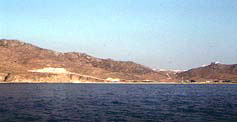
Mykonos (Μύκονος) or Mikonos or Myconos is a barren island in the middle of the Cyclades. It is maybe the island that attracts the most tourists. Because of this and despite its many lovely beaches many cruisers tend to avoid it.
Visiting yachts normally berth at the uncompleted Mykonos Marina two miles W of the main town, which is the only safe harbour on the island. Since its partial completion, yachts are no longer permitted to berth in Mykonos old harbour, which is reserved for tripper boats.
Charts
- BA
- 2682 Kólpos Patalion to Nísos Nísiros
- 1647 Nísos Tínos to Nísos Ikaría
- Imray-Tetra
- G31 Northern Cyclades
- NIMA
- 54334 Plans in the Aegean Sea
- Greek
- Andros to Chalki Island
- Karystos to Naxos
Weather
See Aegean Sea.
Passages
Islands
Communication
- Coast Guard - VHF channel 12 & Tel. +30 2890 23 922
- Olympia Radio - VHF channel 03 & 04
Also see World Cruiser's Nets.
Warning: The channel between Mykonos and Tinos has fierce gusts when the meltemi is blowing.
Berthing
Ports
Mykonos Harbour
Since the partial completion of Mykonos Marina, yachts are no longer permitted to berth in the old harbour, which is reserved for tripper boats.
The harbor is extremely crowded and noisy. It is sheltered from the meltemi but it has considerable swell which can be dangerous. If you must go and they let you go early. It is more quiet at the south-west jetty.
In July 2017, the last berths without mooring lines now had those lines installed so anchoring is no longer required. Every berth now has a mooring line, with power and water also availavle everywhere. Prices are 5 to 8 euro for the mooring and 10 euro for the power and water, with a countdown meter taking money re the usage. You get back the difference if you don't use the full 10euro. We were on shore power for 3 days and took 250l of water and only spent 4 euro total. --Alfa1234Tourlos
Marinas & Yacht Clubs
Anchorages
Ornos Bay
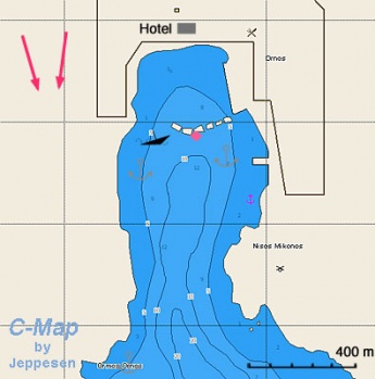
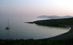
Ornos Bay is the most protected from the meltemi anchorage in the island. There are though, very strong gusts which can come very suddenly during the night. The bottom is weed and at places it provides very poor holding. Not only that, there are also numerous discarded chains, anchors and other debris on the bottom (especially on the East side), all waiting to snag your anchor. A local guy in a dinghy will gladly organize a diver to get you unstuck!
The top end of the bay is filled with mooring balls, forcing you to anchor farther out in deeper water. The bay can get busy and full.
Anchor at 10-12 m and test your anchor. There is a permanent mooring belonging to a fishing caïque, sometimes you can use it overnight. One can eat at the hotel.Platis Yialos
Kato Livadhi
Ayia Anna
Kalafatis
Panormos Bay
Elia Bay
Amenities
| Facilities | |
|---|---|
| Water | None |
| Electricity | None |
| Toilets | None |
| Showers | None |
| Laundry | In the town |
| Garbage | There are bins around the harbor and in several anchorages |
| Supplies | |
| Fuel | None |
| Bottled gas | |
| Chandlers | None |
| Services | |
| Repairs | None |
| Internet | In many cafés. |
| Mobile connectivity | Good 3G & 4G signal |
| Vehicle rentals | In the town |
Provisioning
There are Many stores.
Eating out
- Many restaurants, most overpriced
- Try the specialty of the island: kopanisti, a kind of peppery cheese spread
Transportation
- Daily flights from Athens
- Many ferries
Tourism
History
According to the mythology Mykonos was a rock hurled at the Titans by Poseidon. It was inhabited by Ionian Greeks around 2000 BC. In Roman times Mithridates of Pontus (Black Sea) invaded the island and destroyed its towns. The main town of Chora was rebuild by the Byzantines. Later it was taken over by the Venetians and belonged to the dukedom of Naxos. The remains of the Venetian castle of Paliokastro, built by the Gizzis, still remains. In 1537 Myconos was overtaken by the pirate Barbarossa. From that period on its inhabitants lived mostly by piracy. During the Greek war of independence, these pirates joined the other islands with 22 ships led by Manto Mavrogenous who also donated all of her considerable fortune to the war effort.
Today Mykonos' inhabitants continue to practice a piracy of sorts, preying on their tourist victims with their outrageous prices. Yet, to their credit, they do keep all of the beaches clean.
Places to Visit
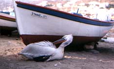
The town of Mykonos is full of boutiques, jewelry stores, etc. Also a lot of dancing discos. There is the mascot of the island Petros a pelican who must be replaced at regular intervals, none of the locals admit this, but he has been there since the 50s!
In Mykonos there is a Archaeological Museum as well as an Aegean Maritime Museum well worth a visit. Also, the Folk Museum (tel. +30 2890 22591), founded in 1959, at the Castle, contains collections of furniture, ceramics, pictures, post-Byzantine sculptures and traditional musical instruments.
Friends
Contact details of "Cruiser's Friends" that can be contacted for local information or assistance.
Forums
List links to discussion threads on partnering forums. (see link for requirements)
Links
- Mykonos at the Wikipedia
- Mykonos at the Wikivoyage
- Aegean Maritime Museum
References
See Greece.
Comments
We welcome users' contributions to the Wiki. Please click on Comments to view other users' comments, add your own personal experiences or recommend any changes to this page following your visit.
Verified by
Date of member's last visit to Mykonos and this page's details validated:
- 1984 (Mykonos Harbour) --Istioploos

 Travels with S/Y Thetis
- 1989 (Platis Yialos) --Istioploos
- 1990 (Ornos Bay) --Istioploos
- 1992 (Ayia Anna) --Istioploos
- April 2007 (Mykonos Harbour) --Athene of Lymington 12:12, 11 July 2011 (BST)
- 2013 (Ornos Bay) --LifePart2

| This is a usable page of the cruising guide. However, please contribute if you can to help it grow further. Click on Comments to add your personal notes on this page or to discuss its contents. Alternatively, if you feel confident to edit the page, click on the edit tab at the top and enter your changes directly. |
| |
|---|
|
Names: Lighthouse, Istioploos, Athene of Lymington |
