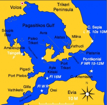
Pagasitikos Gulf
From CruisersWiki
Istioploos (Talk | contribs) (New page: ==Pagasitikos Gulf== Map of Pagasitikos Gulf<br/>''Click for larger view'' ===Background=== [http://en.wikipedia.org/wiki/Pagasetic_Gulf Pag...) |
Istioploos (Talk | contribs) (→Charts) |
||
| Line 11: | Line 11: | ||
===Charts=== | ===Charts=== | ||
| - | + | * BA 1085 Kólpos Petalión to Srimonikos kólpos including Thermaikos kólpos | |
| - | * | + | * BA 1556 Vórios Evoïkós Kólpos and approaches to Vólos |
| - | * | + | * |
| + | * Imray-Tetra G25 Eastern Sporades and North Evvoia | ||
| + | * | ||
| + | * NIMA 54349 Maliakos Kolpos | ||
| + | * NIMA 54351 Approaches to Volos | ||
| + | * | ||
| + | * Greek 31 North Evoikos to Kavala Gulf | ||
| + | * Greek 74 Corinth to Skopelos Island | ||
===Radio Nets=== | ===Radio Nets=== | ||
Revision as of 15:48, 3 July 2008
Pagasitikos Gulf
Background
Pagasitikos Gulf (Παγασιτικός Κόλπος) or the Gulf of Volos and the Trikeri Peninsula at the foot of Mt. Pelion is the enchanted region where the centaur Chiron taught so many mythological heroes including Jason the leader of the Argonauts. This is the place where that mythical journey to the Black Sea began.
The Trikeri Channel that separates Skiathos from Evia and the mainland. In the middle of the channel there is the infamous reef Lefteris., this reef covers a very small area and it is very treacherous. The channel is very busy with traffic and many ships have found their doom on Lefteris. The list includes many of the ships from the Persian fleet of Xerxes on their way to conquer Greece in 480 BC. The reef then was called Myrmes.
Inside the gulf, is a good sailing ground because there are relatively flat seas while the wind, channeled by the mountains can be quite strong.
Charts
- BA 1085 Kólpos Petalión to Srimonikos kólpos including Thermaikos kólpos
- BA 1556 Vórios Evoïkós Kólpos and approaches to Vólos
- Imray-Tetra G25 Eastern Sporades and North Evvoia
- NIMA 54349 Maliakos Kolpos
- NIMA 54351 Approaches to Volos
- Greek 31 North Evoikos to Kavala Gulf
- Greek 74 Corinth to Skopelos Island
Radio Nets
Also see Cruiser's Nets
Submit details of local radio Nets.
Weather
Local weather conditions?
Details?
Check-in facilities
Submit details about facilities for checking in - where to dock, etc.
Ports and Popular Stops
Marinas & Yacht Clubs
Submit Marina details.
Anchorages
List details of all safe anchorages in the area.
Offshore Islands
List Islands
Routes/Passages To/From
Popular passages/routes, timing, etc.
Tourism & things to do ashore
List places of interest, tours, etc.
Fuel, Water, & Electricity
Laundry
Grocery & Supply Stores
Eateries
Internet/WiFi
Available?
Motorbike & Car Rentals
Marine Stores & Facilities
Submit addresses and contact details of marine related businesses that are of interest to cruisers.
Repairs
Transportation
Transportation to mainland or other countries, etc.
References & Publications
Publications, Guides, etc.
Cruiser's Friends
Contact details of "Cruiser's Friends" that can be contacted for local information or assistance.
Forum Discussions
List links to discussion threads on the Cruiser Log Forum
External Links
- Pagasitikos Gulf (Wikipedia)
Personal Notes
Personal experiences?
Last Visited & Details Checked (and updated here)
Date of member's visit to this Port/Stop & this page's details validated:
.
