Pagasitikos Gulf
From CruisersWiki
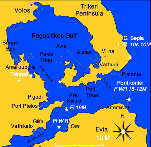


Pagasitikos Gulf (Παγασιτικός Κόλπος) or the Gulf of Volos and the Trikeri Peninsula at the foot of Mt. Pelion is the enchanted region where the centaur Chiron taught so many mythological heroes including Jason the leader of the Argonauts. This is the place where that mythical journey to the Black Sea began.
The Trikeri Channel that separates Skiathos from Evia and the mainland. In the middle of the channel there is the infamous reef Lefteris, this reef covers a very small area and it is very treacherous. The channel is very busy with traffic and many ships have found their doom on Lefteris. The list includes many of the ships from the Persian fleet of Xerxes on their way to conquer Greece in 480 BC. The reef then was called Myrmes. In Lefteris also the heroic Greek submarine Lambros Katsonis was sank with all hands except three crewmen who after swimming for 9 hours made it to Skiathos.
Inside the gulf, is a good sailing ground because there are relatively flat seas while the wind, channeled by the mountains can be quite strong.
Charts
- BA
- 1085 Kólpos Petalión to Srimonikos kólpos including Thermaikos kólpos
- 1556 Vórios Evoïkós Kólpos and approaches to Vólos
- Imray-Tetra
- G25 Eastern Sporades and North Evvoia
- NIMA
- 54349 Maliakos Kolpos
- 54351 Approaches to Volos
- Greek
- 31 North Evoikos to Kavala Gulf
- 74 Corinth to Skopelos Island
Weather
See Aegean Sea.
Passages
Islands

Paleo Trikeri
Paleo Trikeri is a small island with a delightful little harbor. If there is room, you can either moor side-to, stern-to, or anchor off.
Warning: Be aware that you may have to move when either the ferry boat or the hydrofoil arrives. Ask when they are due.
There are three restaurants.
Cape Artemision
Communication
- Goast Guard - VHF channel 12
- Olympia Radio - VHF channels 03 and 60
- Cellular Phone(GSM/GPRS) - Weak signal in Paleo Trikeri
Also see World Cruiser's Nets.
Approached to the gulf are straightforward, but inside the gulf there can be rather strong and gusty winds.
Entrance
The only Greek port of entry/exit this region is Volos.
Berthing
The major harbor in the area is Volos but there are many good anchorages in this region.
Ports
Volos
See .
Orei

Marinas & Yacht Clubs
None.
There is an association of commercial yacht charter operators that apparently call themselves the Volos Yacht Club but their website is not operational.
Anchorages
Andriami Bay
This is a large deserted bay about 3 M E of Trikeri Point, it is open to the S. It provides some protection from the meltemi.
Anchor on the N side in 5-8 m.
Ayia Kiriaki
Port Trikeri
Avra

Vathudi Bay
This bay on the SE corner of the Pagasitikos Gulf is protected by the island of Alatas and has several good anchorages such as Petraki, Milina, and E and S of Alatas. The bay is a popular spot with local sailboats and windsurfs.
There is no problem crossing the narrow channel between the mainland and S of Alatas. The depth is 3.5-4 m in the middle of the channel.Amalioupolis & Soupis Bay
Pigadhi
Glyfa
Vathikelo
Amenities
| Facilities | |
|---|---|
| Water |
|
| Electricity | |
| Toilets | ? |
| Showers | ? |
| Laundry | In Volos |
| Garbage | There are bins around the harbors and in several anchorages.
In Volos there are no liquid waste disposal receptacles for oil, bilge water, etc. If significant quantities are involved the Port Police can arrange for a commercial company to take it. On at least one occasion this in the past there was no charge for this. |
| Supplies | |
| Fuel | |
| Bottled gas | ? |
| Chandlers | n Volos chandleries can be found:
|
| Services | |
| Repairs | In Volos there is Pefkakia Boatyard. Contact Gregory Kartapanis (Tel +30 24210 88612; mob: +30 6945 618 847; email) |
| Internet | In cafés in Volos |
| Mobile connectivity | Good 3G signal in most of the gulf |
| Vehicle rentals | Several agencies in Volos |
Provisioning
Eating out
- Many good restaurants in [Volos]]
- Reasonable food at the Diavlos in Paleo Trikeri
- Taverna in Orei
- Several tavernas in Glyfa
Transportation
Volos is a transport hub for the region:
- Ferry: A number of companies operate from the
 ferry terminal [[Pagasitikos Gulf#ferry terminal|ferry terminal]] 39°21.5601′N, 22°56.6906′E with ferry and hydrofoil to the nearby Northern Sporades Islands, plus connections to Limnos, Lesvos, Chios and Skyros
- Bus: Regular services to and from Athens plus other destinations. The bus station [[Pagasitikos Gulf#bus station|bus station]] 39°21.6537′N, 22°55.9819′E is about 600m west from the fishing boat harbour
- Rail: Regular services to and from Athens plus other destinations. The railway station [[Pagasitikos Gulf#railway station|railway station]] 39°21.8435′N, 22°56.2283′E is about 300m north-west from the fishing boat harbour
- Air: Nea Anchialos National Airport [[Pagasitikos Gulf#Nea Anchialos National Airport|Nea Anchialos National Airport]] 39°12.9949′N, 22°47.5361′E about 30 km SW of the city, or 45km by road services limited domestic flights and seasonal international flights Nea Anchialos National Airport
Tourism
Places to Visit
Mt. Pelio
A land expedition to Mt. Pelio with its many picturesque villages is highly recommended.
In Paleo Trikeri

The Monastery of Panayia, built in 1829, is about 15 minute walk up the hill from the harbor. It is a nice walk and the monastery is very pleasant and well maintained.
Friends
Contact details of "Cruiser's Friends" that can be contacted for local information or assistance.
Forums
List links to discussion threads on partnering forums. (see link for requirements)
Links
- Pagasitikos Gulf at the Wikipedia
- Volos at the Wikipedia
- Volos at the Wikivoyage
References
See Greece.
Comments
We welcome users' contributions to the Wiki. Please click on Comments to view other users' comments, add your own personal experiences or recommend any changes to this page following your visit. Personal experiences?
Verified by
Date of member's last visit to Pagasitikos Gulf and this page's details validated:
- 1986 (Orei, Cape Artemision) --Istioploos

 Travels with S/Y Thetis
- 1991 (Glyfa, Vathikelo) --Istioploos
- September 2000 (Andriami Bay, Ayia Kiriaki, Port Trikeri, Avra, Vathudi Bay, Paleo Trikeri) --Istioploos
- 2010 (Amalioupolis & Soupis Bay) --Vigdis yachtvigdis blog
- 2013 (Orei) --Vigdis yachtvigdis blog
| This is a usable page of the cruising guide. However, please contribute if you can to help it grow further. Click on Comments to add your personal notes on this page or to discuss its contents. Alternatively, if you feel confident to edit the page, click on the edit tab at the top and enter your changes directly. |
| |
|---|
|
Names: Istioploos, Yachtbillabong |