Punta Arenas
From CruisersWiki
Istioploos (Talk | contribs) m (Reverted edits by Riley Huntley (talk) to last revision by Haiqu) |
|||
| Line 1: | Line 1: | ||
| + | {{infobox |53|10.5|S|070|54.7|W| | ||
| + | | gallery = | ||
| + | | chartlet= | ||
| + | | maplat= | ||
| + | | maplon= | ||
| + | | mapzoom= | ||
| + | | image= Porvenir-01.jpg | ||
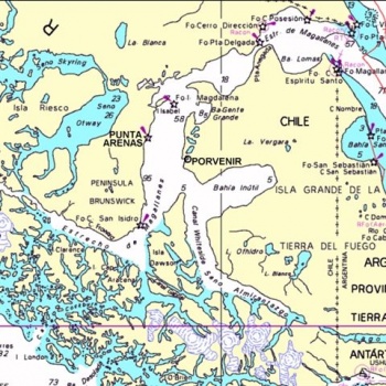
| + | | imagetext= Map of {{magenta|Estrecho de Magallanes with Punta Arenas and Porvenir}} | ||
| + | ''click for larger view'' | ||
| + | }} | ||
| + | {{TOCleft}} | ||
| + | |||
==Punta Arenas== | ==Punta Arenas== | ||
| - | |||
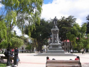
[[Image:PAmonument.jpg|300px|thumb|right|Magallanes monument<br>Photo: Frank Holden s/v Westerly Serenade]] | [[Image:PAmonument.jpg|300px|thumb|right|Magallanes monument<br>Photo: Frank Holden s/v Westerly Serenade]] | ||
| Line 10: | Line 21: | ||
It now has a population in the order of 120,000. | It now has a population in the order of 120,000. | ||
| - | === | + | ==Local Weather== |
| - | + | [[Chile#Weather forecast sources| Weather forecast sources]] | |
| - | + | ||
| + | ==Charts== | ||
| + | [[Chile#Chile Navigation Charts|Which charts and where to buy]] | ||
| + | |||
| + | Chilean charts: 11000, 11400, 11410, 11700 | ||
===Radio Nets=== | ===Radio Nets=== | ||
| - | ''Also see [[World MM Nets|World Cruiser's Nets]]'' | + | [[Chile#Local Radio Nets| Local Radio Nets]] |
| + | |||
| + | ''Also see [[World MM Nets|World Cruiser's Nets]]''. | ||
Patagonian Cruisers' Net, 8164 USB, 0900 Chilean Local Time daily. | Patagonian Cruisers' Net, 8164 USB, 0900 Chilean Local Time daily. | ||
| Line 30: | Line 47: | ||
===Anchorages=== | ===Anchorages=== | ||
| - | There are no safe all weather anchorages along this shore. The nearest one is at Porvenir, 19 miles away across Magallanes on Tierra del Fuego | + | There are no safe all weather anchorages along this shore. The nearest one is at [[Porvenir|Porvenir]], 19 miles away across Magallanes on Tierra del Fuego and it is a handy place to wait for suitable weather to clear in and out of Punta Arenas. |
===Tourism & things to do ashore=== | ===Tourism & things to do ashore=== | ||
| Line 67: | Line 84: | ||
===Personal Notes=== | ===Personal Notes=== | ||
| - | + | ([[User:Danbag|Danbag]]) in december 2014 take a buoy near the Muelle Prat and we go ashore in the middle of the morning with the tender to the small beach in the east side of the muelle, the weather was settled and there is no wind. When we returned after cleared out and with some provisions in the first afternoon a small east wind was blowing but the waves where not small... to return on board from the beach was not easy and we wet to completely overcome the breaking waves on the beach. On the boat the tolling was terrible so we started immediately even if the tide was not yet favorable. But in any case we where be able to pass the two angosture to the Atlantic in the same tide. | |
* | * | ||
Revision as of 15:38, 20 June 2015
| Punta Arenas
| |
|
Punta Arenas
Background
Punta Arenas ( Sandy Point) was settled in 1848 after the failure of a settlement at Fuerte Bulnes, down the coast towards Cabo Froward, which had been established some five years previously.
The main reason for the establishment and ongoing existence of Punta Arenas was as a coaling port for steamers voyaging between the Atlantic and Pacific Oceans. This brought a period of prosperity to the city which was enhanced by the wool industry which flourished from about 1890 onwards. The coaling industry went into a rapid decline after the opening of the Panama Canal in 1914 however the port is still busy and the old prosperity can be seen in the architecture of the city centre.
It now has a population in the order of 120,000.
Local Weather
Charts
Chilean charts: 11000, 11400, 11410, 11700
Radio Nets
Also see World Cruiser's Nets.
Patagonian Cruisers' Net, 8164 USB, 0900 Chilean Local Time daily.
Port Facilities
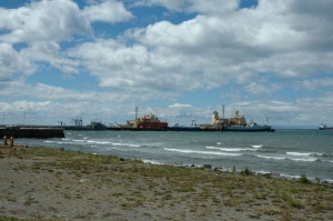
Punta Arenas still has just a single finger pier, Muelle Prat - designed for large ships, jutting out into an open roadstead. While this roadstead is sheltered from the prevailing NW'ly winds it is very open to winds from all other directions. Yachts did call here in the 50's and 60's but today with the availability of the two ports in Canal Beagle there is really no need. Rarely do you meet a yacht that has spent time here and not incurred some damage.
Check-in facilities
Punta Arenas is an Armada port, normal requirements regarding Zarpes apply. The Capitania de Puerto, Immigration, Aduana and a decent Supermercado all lie within a block of the Mulle Prat gate. It is possible to complete all formalities, store ship and be on your way within 3 hours.
Marinas & Yacht Clubs
Nil
Anchorages
There are no safe all weather anchorages along this shore. The nearest one is at Porvenir, 19 miles away across Magallanes on Tierra del Fuego and it is a handy place to wait for suitable weather to clear in and out of Punta Arenas.
Tourism & things to do ashore
Marine stores
- Ultramar Agencias Maritima Ltda are the local chart agents. They are at Independencia 865.
Offshore Islands
List Islands
References & Publications
Publications, etc.
Cruiser's Friends
Contact details of "Cruiser's Friends" that can be contacted for local information or assistance.
Forum Discussions
List links to discussion threads on partnering forums. (see link for requirements)
External Links
Links to relevant websites.
Personal Notes
(Danbag) in december 2014 take a buoy near the Muelle Prat and we go ashore in the middle of the morning with the tender to the small beach in the east side of the muelle, the weather was settled and there is no wind. When we returned after cleared out and with some provisions in the first afternoon a small east wind was blowing but the waves where not small... to return on board from the beach was not easy and we wet to completely overcome the breaking waves on the beach. On the boat the tolling was terrible so we started immediately even if the tide was not yet favorable. But in any case we where be able to pass the two angosture to the Atlantic in the same tide.
|
|---|
|
Names: |
| |
|---|
| | HOMEPAGE | Wiki Contents | South America | East Pacific | South Atlantic | Chile | Punta Arenas | |


