Salerno
From CruisersWiki
Lighthouse (Talk | contribs) m (Text replace - "List links to forum discussion threads" to "List links to discussion threads on partnering forums. (see link for requirements)") |
|||
| Line 5: | Line 5: | ||
|- | |- | ||
! <center>[[image:World_icon.png]]</center> | ! <center>[[image:World_icon.png]]</center> | ||
| - | | {{Coord| | + | | {{Coord|40|39.98|N|14|44.6|E|}} |
|- | |- | ||
! <center>[[image:Photo_icon.png]]</center> | ! <center>[[image:Photo_icon.png]]</center> | ||
| - | | [ Photo gallery] | + | | [http://www.panoramio.com/map/#lt=40.835470&ln=14.261198&z=2&k=2&a=1&tab=1 Photo gallery] |
|- | |- | ||
! <center>[[image:Chart_icon.png]]</center> | ! <center>[[image:Chart_icon.png]]</center> | ||
| - | | [ Local chartlet] | + | | [http://mapserver.mytopo.com/homepage/index.cfm?lat=40.8295&lon=14.2655&scale=60000&zoom=50&type=0&icon=0&searchscope=dom&CFID=3460065&CFTOKEN=38761686&scriptfile=http://mapserver.mytopo.com/homepage/index.cfm&latlontype=DMS Local chartlet] |
|} | |} | ||
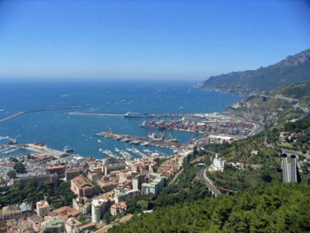
| - | [[Image: | + | [[Image:SalernoHarbour.jpg|350px|thumb|right| Salerno harbour looking SW<br/>''Click for larger view'']] |
| - | + | The city of Salerno lies at the head of the gulf of the same name on the Tyrrhenian coast of Italy, some 30 miles SE of [[Naples]]. Originally an Etruscan settlement, the town developed under the Romans with the construction of a road, the Via Popilia, connecting it with Rome and the settlements further south. By the 9th century AD the city had become the centre of an important principality and was already developing as a renowned centre of learning, its medical school being celebrated all over Europe. The city continued to grow under successive Norman, Hohenstaufen and Angevin rulers and by the unification of Italy in the 19th century had become a major industrial centre. The city suffered considerable damage in September 1943, when it was the focus of major Allied landings, Operation Avalanche, designed to push the Axis forces out of Italy. Today the city is a busy commercial port and, for cruising yachts, a useful spot to berth a vessel for visits to the attractions of Pompeii, Paestum, the Amalfi Coast and even the island of Capri. Yachts berth either in the '''Porto Nuovo''', the commercial harbour, on the pontoons at the NW corner of the '''Porto Turistico''' just E of the commercial harbour, or (if there is space) in the cramped harbour of '''Porto Masuccio Salernitano''' at the eastern side of the Porto Turistico. | |
| - | + | ||
| - | + | ||
==Charts== | ==Charts== | ||
| - | + | British Admiralty 1908, 908 | |
| - | + | ||
| - | + | Italian charts 914, 10, 110, 96 | |
| - | + | ||
==Radio Nets== | ==Radio Nets== | ||
| Line 30: | Line 27: | ||
==Local Weather== | ==Local Weather== | ||
| - | + | Winds along the Tyrrhenian Coast of Italy are generally light in the summer months. The most notable feature is a SW seabreeze that kicks in in late morning and blows at little more than Force 2 - 4 until the evening. Thundery conditions are not infrequent during early Spring and Autumn, and associated winds can sometimes reach gale force and kick up a substantial sea. In winter, gales can blow from both NW and S and entry to and exit from some of the harbours along the coast can become hazardous. | |
| + | Sources for weather information: | ||
| + | * There is a continuous (computerised voice) weather forecast on VHF 68 - first in Italian and then followed with an English translation. | ||
| + | * The same forecast is given in Italian and English on VHF coastal stations following a notification on channel 16. | ||
| + | * Navtex weather forecasts are broadcast from stations at La Garde (Toulon), Roma and Cagliari (Sardinia). | ||
| + | ==Approach and Navigation== | ||
| + | The apartment blocks and other buildings of the city are visible from a considerable distance. Closer in, the long breakwater of Molo di Levante will be seen; the Porto Nuovo lies to the W of the mole between it and the shorter Molo di Ponente and is entered from WSW; the Porto Turistico lies to the E of Molo di Levante and is tucked into the top NW corner round the ‘elbow’ of Molo di Levante. | ||
| - | + | ==Check-in and Facilities== | |
| - | + | '''Porto Nuovo''' [[image:World_icon.png]] {{Coord|40|39.98|N|14|44.6|E|}} contains a series of pontoons situated at the NE corner of the commercial harbour. The pontoons are operated by seven separate concessionaires providing a total of over 1,000 berths, of which 117 are supposedly for yachts in transit (though don’t count on it during the season). Depths at the pontoons vary from 2.0 to 5.0 metres. It is basically a question here of approaching the pontoons and trying to negotiate a berth. Shelter is good except in strong southerlies, which send in an uncomfortable swell. No toilets or showers. | |
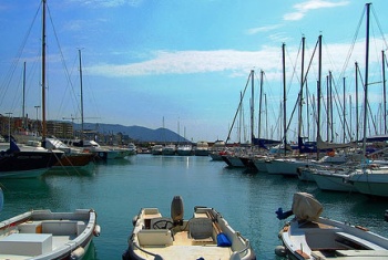
| + | [[Image:PortoNuovo.jpg|350px|thumb|right| Pontoon berths in Porto Nuovo<br/>''Click for larger view'']] | ||
| - | |||
| - | |||
| - | + | '''Masuccio Salernitano''' [[image:World_icon.png]] {{Coord|40|40.44|N|14|45.91|E|}} is a small basin located at the SE corner of the Porto Turistico. The basin has a total of 414 berths on nine pontoons operated by the Italian Lega Navale, the Yachting Club Saliternano the concessionaire CVS. Again, there are supposedly 41 berths reserved for yachts in transit. Maximum length 16 metres. Depths in the basin are from 2.0 - 5.0 metres. In practice it is hard to find a berth in here, especially during the peak summer period. Toilets and showers at the Lega Navale clubhouse. Bars and restaurant in the basin. | |
| - | + | [[Image:Masuccio.jpg|350px|thumb|right| Berths in Porto Masuccio Salernitano<br/>''Click for larger view'']] | |
| + | |||
| + | |||
| + | '''Porto Turistico''' [[image:World_icon.png]] {{Coord|40|40.44|N|14|45.24|E|}} has a small enclosed basin at its NW corner with a series of 16 pontoons operate by private concessionaires. As with Porto Nuovo, it is a question of approaching the pontoons and trying to negotiate a berth. The pontoons are usually crammed to capacity with local yachts. Shelter is good here in most conditions, although strong southerlies send in an uncomfortable swell, as in Porto Nuovo. No toilets or showers. | ||
==Offshore Islands and Groups== | ==Offshore Islands and Groups== | ||
| - | + | * [[Capri]] | |
| - | + | ||
| - | * | + | |
==Marinas & Yacht Clubs== | ==Marinas & Yacht Clubs== | ||
| - | * | + | * Lega Navale |
| - | * | + | * Yachting Club Salernitano |
| - | + | ||
==Anchorages== | ==Anchorages== | ||
| - | + | There are no suitable anchorages in Salerno harbour, although in extremis a yacht can anchor off the ‘beach’ at the N end of the Porto Turistico. | |
| - | + | ||
| - | + | ||
| - | + | ||
==Yacht Repairs and Services== | ==Yacht Repairs and Services== | ||
| Line 63: | Line 62: | ||
====Repairs/Yards==== | ====Repairs/Yards==== | ||
| - | + | Yard in NE corner of Porto Nuovo with hard standing and indoor storage; slipways (up to 150 T); mobile crane (30 T); engine, electrical and electronic repairs; all kinds of hull repairs; sail repairs; divers. | |
====Fuel, Water, & Electricity==== | ====Fuel, Water, & Electricity==== | ||
| - | + | Fuel station in the Porto Masuccio Salernitano at the eastern end of the Porto Turistico (0800 - 1900). Water and electricity on some of the pontoons in the Porto Nuovo and Porto Masuccio Salernitano; also on the transit quay in the Porto Turistico. | |
| - | + | ||
| - | + | ||
| - | + | ||
| - | ; | + | |
| - | + | ||
==Tourism and Things to do Ashore== | ==Tourism and Things to do Ashore== | ||
===Tourism=== | ===Tourism=== | ||
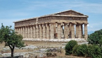
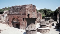
| - | + | Salerno itself has few attractions, other than a pretty, if somewhat decrepit mediaeval quarter. However, the city’s good transport links and car rental outlets make it an idea spot to base yourself for exploring the surrounding attractions of Pompeii, Paestum (with its three wonderful Greek temples and fascinating museum) and even the island of [[Capri]], to which there is a ferry and hydrofoil service. | |
| - | + | <center style="clear: both;"><gallery caption="Gallery" widths="210px" heights="150px" perrow="4"> | |
| - | + | Image:PaestumApollo.jpg|Temple of Apollo, Paestum | |
| + | Image:PaestumAthena.jpg|Temple of Athena, Paestum | ||
| + | Image:PompeiiBakery.jpg|Bakery, Pompeii | ||
| + | </gallery></center> | ||
===Grocery & Supply Stores=== | ===Grocery & Supply Stores=== | ||
| - | * | + | * Excellent provisions shops in the town. |
* | * | ||
===Eateries=== | ===Eateries=== | ||
| - | * | + | * Numerous restaurants, pizzerias and bars near the harbour. |
| - | * | + | * |
===Internet/WiFi=== | ===Internet/WiFi=== | ||
| - | + | None. | |
===Laundry=== | ===Laundry=== | ||
| - | * | + | * |
| - | * | + | * |
===Motorbike & Car Rentals=== | ===Motorbike & Car Rentals=== | ||
| - | * | + | *Several rental outlets in the town. |
===Garbage Disposal=== | ===Garbage Disposal=== | ||
| - | + | Bins around the harbour. | |
===Transportation=== | ===Transportation=== | ||
| - | + | Hourly buses to Paestum. Trains and buses to Rome and [[Naples]]. Ferries to [[Capri]], [[Ischia]], [[Amalfi]] and [[Positano]]. | |
| - | + | ||
==Routes/Passages To/From== | ==Routes/Passages To/From== | ||
| Line 115: | Line 111: | ||
* | * | ||
* | * | ||
| - | |||
| - | |||
==External Links== | ==External Links== | ||
Links to relevant websites. | Links to relevant websites. | ||
* | * | ||
* | * | ||
| - | |||
| - | |||
==References & Publications== | ==References & Publications== | ||
Publications, Guides, etc. | Publications, Guides, etc. | ||
* | * | ||
* | * | ||
| - | |||
| - | |||
==''Last Visited & Details Checked (and updated here)''== | ==''Last Visited & Details Checked (and updated here)''== | ||
''Date of member's visit to this Port/Stop & this page's details validated'': | ''Date of member's visit to this Port/Stop & this page's details validated'': | ||
| - | * | + | * August 2003 --[[User:Atheneoflymington|Athene of Lymington]] 14:58, 16 December 2010 (UTC) |
* | * | ||
==Personal Notes== | ==Personal Notes== | ||
Personal experiences? | Personal experiences? | ||
| - | * | + | * The Porto Nuovo pontoons in Salerno are imprinted on our memories as the only place in the Mediterranean where we have had the question: ‘how much to moor here?’ answered with the question: ‘how much are you prepared to pay?’ --[[User:Atheneoflymington|Athene of Lymington]] 14:58, 16 December 2010 (UTC) |
| Line 145: | Line 135: | ||
! <h2 id="mp-itn-h2" style="margin:0; background:#cedff2; font-size:120%; font-weight:bold; border:1px solid #a3b0bf; text-align:left; color:#000; padding:0.2em 0.4em;">Cruising Wiki Navigation</h2> | ! <h2 id="mp-itn-h2" style="margin:0; background:#cedff2; font-size:120%; font-weight:bold; border:1px solid #a3b0bf; text-align:left; color:#000; padding:0.2em 0.4em;">Cruising Wiki Navigation</h2> | ||
|- | |- | ||
| - | |style="color:#000;"| | [[World_Cruising_and_Sailing_Wiki|HOMEPAGE]] | [[World Cruising Guides|Wiki Contents]] | [[Mediterranean Sea Cruising Guide|Mediterranean]] | [[Italy]] | [[ | + | |style="color:#000;"| | [[World_Cruising_and_Sailing_Wiki|HOMEPAGE]] | [[World Cruising Guides|Wiki Contents]] | [[Mediterranean Sea Cruising Guide|Mediterranean]] | [[Italy]] | [[Naples]] | |
|} | |} | ||
Revision as of 14:58, 16 December 2010
Salerno, Italy
| | |
| | 40°39.98′N, 14°44.6′E |
|---|---|
| | Photo gallery |
| | Local chartlet |
The city of Salerno lies at the head of the gulf of the same name on the Tyrrhenian coast of Italy, some 30 miles SE of Naples. Originally an Etruscan settlement, the town developed under the Romans with the construction of a road, the Via Popilia, connecting it with Rome and the settlements further south. By the 9th century AD the city had become the centre of an important principality and was already developing as a renowned centre of learning, its medical school being celebrated all over Europe. The city continued to grow under successive Norman, Hohenstaufen and Angevin rulers and by the unification of Italy in the 19th century had become a major industrial centre. The city suffered considerable damage in September 1943, when it was the focus of major Allied landings, Operation Avalanche, designed to push the Axis forces out of Italy. Today the city is a busy commercial port and, for cruising yachts, a useful spot to berth a vessel for visits to the attractions of Pompeii, Paestum, the Amalfi Coast and even the island of Capri. Yachts berth either in the Porto Nuovo, the commercial harbour, on the pontoons at the NW corner of the Porto Turistico just E of the commercial harbour, or (if there is space) in the cramped harbour of Porto Masuccio Salernitano at the eastern side of the Porto Turistico.
Charts
British Admiralty 1908, 908
Italian charts 914, 10, 110, 96
Radio Nets
Also see World Cruiser's Nets
Local Weather
Winds along the Tyrrhenian Coast of Italy are generally light in the summer months. The most notable feature is a SW seabreeze that kicks in in late morning and blows at little more than Force 2 - 4 until the evening. Thundery conditions are not infrequent during early Spring and Autumn, and associated winds can sometimes reach gale force and kick up a substantial sea. In winter, gales can blow from both NW and S and entry to and exit from some of the harbours along the coast can become hazardous. Sources for weather information:
- There is a continuous (computerised voice) weather forecast on VHF 68 - first in Italian and then followed with an English translation.
- The same forecast is given in Italian and English on VHF coastal stations following a notification on channel 16.
- Navtex weather forecasts are broadcast from stations at La Garde (Toulon), Roma and Cagliari (Sardinia).
The apartment blocks and other buildings of the city are visible from a considerable distance. Closer in, the long breakwater of Molo di Levante will be seen; the Porto Nuovo lies to the W of the mole between it and the shorter Molo di Ponente and is entered from WSW; the Porto Turistico lies to the E of Molo di Levante and is tucked into the top NW corner round the ‘elbow’ of Molo di Levante.
Check-in and Facilities
Porto Nuovo ![]() 40°39.98′N, 14°44.6′E contains a series of pontoons situated at the NE corner of the commercial harbour. The pontoons are operated by seven separate concessionaires providing a total of over 1,000 berths, of which 117 are supposedly for yachts in transit (though don’t count on it during the season). Depths at the pontoons vary from 2.0 to 5.0 metres. It is basically a question here of approaching the pontoons and trying to negotiate a berth. Shelter is good except in strong southerlies, which send in an uncomfortable swell. No toilets or showers.
40°39.98′N, 14°44.6′E contains a series of pontoons situated at the NE corner of the commercial harbour. The pontoons are operated by seven separate concessionaires providing a total of over 1,000 berths, of which 117 are supposedly for yachts in transit (though don’t count on it during the season). Depths at the pontoons vary from 2.0 to 5.0 metres. It is basically a question here of approaching the pontoons and trying to negotiate a berth. Shelter is good except in strong southerlies, which send in an uncomfortable swell. No toilets or showers.
Click for larger view
Masuccio Salernitano ![]() 40°40.44′N, 14°45.91′E is a small basin located at the SE corner of the Porto Turistico. The basin has a total of 414 berths on nine pontoons operated by the Italian Lega Navale, the Yachting Club Saliternano the concessionaire CVS. Again, there are supposedly 41 berths reserved for yachts in transit. Maximum length 16 metres. Depths in the basin are from 2.0 - 5.0 metres. In practice it is hard to find a berth in here, especially during the peak summer period. Toilets and showers at the Lega Navale clubhouse. Bars and restaurant in the basin.
40°40.44′N, 14°45.91′E is a small basin located at the SE corner of the Porto Turistico. The basin has a total of 414 berths on nine pontoons operated by the Italian Lega Navale, the Yachting Club Saliternano the concessionaire CVS. Again, there are supposedly 41 berths reserved for yachts in transit. Maximum length 16 metres. Depths in the basin are from 2.0 - 5.0 metres. In practice it is hard to find a berth in here, especially during the peak summer period. Toilets and showers at the Lega Navale clubhouse. Bars and restaurant in the basin.
Porto Turistico ![]() 40°40.44′N, 14°45.24′E has a small enclosed basin at its NW corner with a series of 16 pontoons operate by private concessionaires. As with Porto Nuovo, it is a question of approaching the pontoons and trying to negotiate a berth. The pontoons are usually crammed to capacity with local yachts. Shelter is good here in most conditions, although strong southerlies send in an uncomfortable swell, as in Porto Nuovo. No toilets or showers.
40°40.44′N, 14°45.24′E has a small enclosed basin at its NW corner with a series of 16 pontoons operate by private concessionaires. As with Porto Nuovo, it is a question of approaching the pontoons and trying to negotiate a berth. The pontoons are usually crammed to capacity with local yachts. Shelter is good here in most conditions, although strong southerlies send in an uncomfortable swell, as in Porto Nuovo. No toilets or showers.
Offshore Islands and Groups
Marinas & Yacht Clubs
- Lega Navale
- Yachting Club Salernitano
Anchorages
There are no suitable anchorages in Salerno harbour, although in extremis a yacht can anchor off the ‘beach’ at the N end of the Porto Turistico.
Yacht Repairs and Services
Marine Stores
Submit addresses and contact details of marine related businesses that are of interest to cruisers.
Repairs/Yards
Yard in NE corner of Porto Nuovo with hard standing and indoor storage; slipways (up to 150 T); mobile crane (30 T); engine, electrical and electronic repairs; all kinds of hull repairs; sail repairs; divers.
Fuel, Water, & Electricity
Fuel station in the Porto Masuccio Salernitano at the eastern end of the Porto Turistico (0800 - 1900). Water and electricity on some of the pontoons in the Porto Nuovo and Porto Masuccio Salernitano; also on the transit quay in the Porto Turistico.
Tourism and Things to do Ashore
Tourism
Salerno itself has few attractions, other than a pretty, if somewhat decrepit mediaeval quarter. However, the city’s good transport links and car rental outlets make it an idea spot to base yourself for exploring the surrounding attractions of Pompeii, Paestum (with its three wonderful Greek temples and fascinating museum) and even the island of Capri, to which there is a ferry and hydrofoil service.
Grocery & Supply Stores
- Excellent provisions shops in the town.
Eateries
- Numerous restaurants, pizzerias and bars near the harbour.
Internet/WiFi
None.
Laundry
Motorbike & Car Rentals
- Several rental outlets in the town.
Garbage Disposal
Bins around the harbour.
Transportation
Hourly buses to Paestum. Trains and buses to Rome and Naples. Ferries to Capri, Ischia, Amalfi and Positano.
Routes/Passages To/From
Popular passages/routes, timing, etc.
Cruiser's Friends
Contact details of "Cruiser's Friends" that can be contacted for local information or assistance.
Forum Discussions
List links to discussion threads on partnering forums. (see link for requirements)
External Links
Links to relevant websites.
References & Publications
Publications, Guides, etc.
Last Visited & Details Checked (and updated here)
Date of member's visit to this Port/Stop & this page's details validated:
- August 2003 --Athene of Lymington 14:58, 16 December 2010 (UTC)
Personal Notes
Personal experiences?
- The Porto Nuovo pontoons in Salerno are imprinted on our memories as the only place in the Mediterranean where we have had the question: ‘how much to moor here?’ answered with the question: ‘how much are you prepared to pay?’ --Athene of Lymington 14:58, 16 December 2010 (UTC)
| |
|---|
| | HOMEPAGE | Wiki Contents | Mediterranean | Italy | Naples | |
.


