Sućuraj
From CruisersWiki
m |
Istioploos (Talk | contribs) (Chartlet) |
||
| Line 1: | Line 1: | ||
| - | == | + | {{Infobox |43|7.51|N|17|11.37|E| |
| - | {| class="infobox bordered" style="width: | + | | mapzoom= 17 |
| + | | image= SucurajAerial.jpg | ||
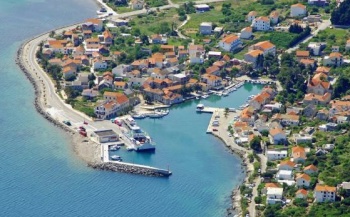
| + | | imagetext= Harbour of Sucuraj from SE - ''Click for larger view'' | ||
| + | }} {{TOCleft}} | ||
| + | {| class="infobox bordered" style="width: 28em; text-align: right; font-size: 90%;" | ||
|- | |- | ||
| - | + | | colspan="2" style="text-align:center;" | <googlemap lat="43.126359" lon="17.189999" zoom="15" width="352" scale="yes"></googlemap> | |
| - | + | ||
| - | + | ||
| - | + | ||
| - | + | ||
| - | + | ||
| - | + | ||
| - | + | ||
| - | + | ||
| - | + | ||
| - | + | ||
| - | + | ||
| - | | colspan="2" style="text-align:center;" | <googlemap lat="43.126359" lon="17.189999" zoom="15" width=" | + | |
| - | </googlemap> | + | |
|} | |} | ||
| - | + | The small harbour of Sućuraj lies at the extreme E tip of the island of [[Hvar]] in [[Croatia]], on the S side of the cape of the same name and just over two miles SW of the mainland ferry terminal and fishing harbour of Drvenik. The setting is spectacular, being only a few miles from the 1762 metre high mountain of Biokovo on the mainland. For years, Sucuraj was just a stopping off point for the car ferries and a sleepy fishing port, but with the installation of wooden catwalks and laid moorings the harbour is now much more yacht-friendly, albeit still not heavily frequented by yachts – just the occasional flotilla. As the only harbour of any size in the E half of Hvar Island, it is a handy port of call before heading to the mainland harbours of [[Makarska]] or [[Ploce]]. Shelter is good in all but strong E or SE winds, which send in a very uncomfortable swell. | |
| - | [[ | + | |
| - | [[ | + | |
| - | [[ | + | |
| - | + | ==Local Weather== | |
| + | Diurnal winds among the islands are mostly moderate during the summer months, predominantly from NW and rarely exceeding force 4/5, although gusting is common in narrow channels between islands and on the lee side of headlands. At night, katabatic winds off the mountains affect some of the islands close to the mainland coast. During early spring and (especially) autumn conditions can be more unsettled, occasionally accompanied by violent thunderstorms - luckily of short duration - with winds of 30-35 knots or more and vicious, steep seas. In the winter the sudden, violent N wind off the mountains, the ''bora'', is much to be feared, especially along the coast from Rijeka down to Zadar, although its effects can be felt as far south as Split. | ||
| + | |||
| + | Equally prevalent in winter - although not uncommon in summer - is the ''scirocco'', a S/SE wind that blows up from North Africa, usually in advance of a depression moving E across the Mediterranean. Unlike the ''bora'', the ''scirocco'' only occasionally exceeds gale force, but is still a phenomenon to be wary of, especially if on a lee coast. | ||
| + | |||
| + | ''For sources of weather forecasting, see [[Croatia#Sources of weather forecast info|Croatia]]''. | ||
==Charts== | ==Charts== | ||
| Line 30: | Line 23: | ||
: MK20 | : MK20 | ||
; Imray | ; Imray | ||
| - | : M26 (Split to Dubrovnik) | + | : M26 (Split to Dubrovnik) |
| - | == | + | ==Radio Nets== |
| - | + | * | |
| + | * | ||
| - | + | ''Also see [[World MM Nets|World Cruiser's Nets]]''. | |
| - | + | ||
| - | + | ||
==Approach and Navigation== | ==Approach and Navigation== | ||
| Line 43: | Line 35: | ||
==Check-in facilities (for Customs and Immigration)== | ==Check-in facilities (for Customs and Immigration)== | ||
| - | Hvar Town is the nearest summer port of entry. At other times of year, [[Split]] or [[Korcula]] are the nearest year-round ports of entry. | + | [[Hvar Town]] is the nearest summer port of entry. At other times of year, [[Split]] or [[Korcula]] are the nearest year-round ports of entry. |
| + | |||
| + | ==Berthing Options== | ||
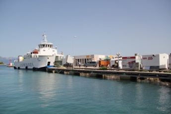
| + | {{Image right| SucurajSCatwalk.jpg| The S catwalk has eight laid moorings, right next to the ferry berth<br />''Click for larger view''}} | ||
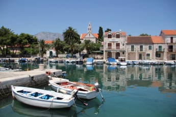
| + | {{Image right| SucurajWCatwalk.jpg| Yachts lie alongside on the E catwalk - ''Click for larger view''}} | ||
| - | |||
Following the installation of a wooden L-shaped catwalk immediately W of the ferry quay, yachts are now berthed stern or bows-to on the S section of the catwalk (where there are eight laid moorings) or alongside on the W section (where there is space for two yachts alongside). The catwalk is equipped with stout stainless steel mooring rings and black fenders along its entire length. Depths are 3.0 - 4.0 metres, the deeper water being nearer the ferry quay. Note that the lines to the mooring blocks are very long and therefore descend at a shallow angle; this needs to be borne in mind when departing. | Following the installation of a wooden L-shaped catwalk immediately W of the ferry quay, yachts are now berthed stern or bows-to on the S section of the catwalk (where there are eight laid moorings) or alongside on the W section (where there is space for two yachts alongside). The catwalk is equipped with stout stainless steel mooring rings and black fenders along its entire length. Depths are 3.0 - 4.0 metres, the deeper water being nearer the ferry quay. Note that the lines to the mooring blocks are very long and therefore descend at a shallow angle; this needs to be borne in mind when departing. | ||
It is no longer advisable to moor along the breakwater as this is heavily used by regular tripper boats. In any case, you will be directed where to berth by one of the two female harbour mistresses. | It is no longer advisable to moor along the breakwater as this is heavily used by regular tripper boats. In any case, you will be directed where to berth by one of the two female harbour mistresses. | ||
| - | ==Marinas & Yacht Clubs== | + | ===Marinas & Yacht Clubs=== |
None. | None. | ||
| - | ==Anchorages== | + | ===Anchorages=== |
None. | None. | ||
| Line 61: | Line 56: | ||
====Fuel, Water, & Electricity==== | ====Fuel, Water, & Electricity==== | ||
No fuel. Three water and electricity stanchions on the catwalk and others on the quays. | No fuel. Three water and electricity stanchions on the catwalk and others on the quays. | ||
| + | {{hold vertical}} | ||
==Things to do Ashore== | ==Things to do Ashore== | ||
====Tourism==== | ====Tourism==== | ||
| - | + | {{Image right| SucurajInnerHarbour.jpg| Sucuraj inner harbour is for small craft only - ''Click for larger view''}} | |
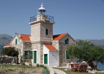
| - | + | {{Image right| SucurajLighthouse.jpg| Sucuraj lighthouse is also a cosy holiday let - ''Click for larger view''}} | |
| + | |||
Sucuraj is an ancient town, with traces of civilization dating back to Illyrian times. The town retains a largely mediaeval street plan, its narrow lanes crowded with old stone houses. The Baroque church of St Anthony of Padua in the town is worth a visit, as is the nearby Monastery of St Augustin (now occupied by a Franciscan order), begun in the 13th century. Finally, the walk down to the lighthouse on Cape Sucuraj is rewarded with superb views over to the peak of Mount Biokovo. | Sucuraj is an ancient town, with traces of civilization dating back to Illyrian times. The town retains a largely mediaeval street plan, its narrow lanes crowded with old stone houses. The Baroque church of St Anthony of Padua in the town is worth a visit, as is the nearby Monastery of St Augustin (now occupied by a Franciscan order), begun in the 13th century. Finally, the walk down to the lighthouse on Cape Sucuraj is rewarded with superb views over to the peak of Mount Biokovo. | ||
====Grocery & Supply Stores==== | ====Grocery & Supply Stores==== | ||
| - | Small Konzum supermarket and provisions shops. | + | Small ''Konzum'' supermarket and provisions shops. |
====Eateries==== | ====Eateries==== | ||
| Line 91: | Line 88: | ||
==Routes/Passages To/From== | ==Routes/Passages To/From== | ||
| - | + | ''See [[Croatia#Popular_Routes.2FCruises|Croatia]]''. | |
==Cruiser's Friends== | ==Cruiser's Friends== | ||
| Line 98: | Line 95: | ||
==Forum Discussions== | ==Forum Discussions== | ||
| - | List links to discussion threads on [[Cruising Forums|partnering forums]]. (see link for requirements) | + | List links to discussion threads on [[Cruising Forums|partnering forums]]. (''see link for requirements'') |
* [http://www.cruisersforum.com/forums/tags/croatia.html Croatia Sailing and Cruising Discussions on Cruisers Forum] | * [http://www.cruisersforum.com/forums/tags/croatia.html Croatia Sailing and Cruising Discussions on Cruisers Forum] | ||
| - | * | + | * |
==External Links== | ==External Links== | ||
| + | * {{wikipedia|Sućuraj}} | ||
* [http://www.hvarinfo.com/ Hvar Tourism website] | * [http://www.hvarinfo.com/ Hvar Tourism website] | ||
| - | '' | + | * |
| + | |||
| + | For other useful websites, ''see [[Croatia#External_Links|Croatia]]''. | ||
==References & Publications== | ==References & Publications== | ||
| Line 112: | Line 112: | ||
Personal experiences? | Personal experiences? | ||
* A delightful, largely unspoilt little harbour usually bypassed by most yachts. We were here in early July with only two other yachts in the harbour. However, it became very uncomfortable in SE winds gusting 15-20 knots and I wouldn't recommend a visit with much over SE 10 knots. --[[User:Atheneoflymington|Athene of Lymington]] | * A delightful, largely unspoilt little harbour usually bypassed by most yachts. We were here in early July with only two other yachts in the harbour. However, it became very uncomfortable in SE winds gusting 15-20 knots and I wouldn't recommend a visit with much over SE 10 knots. --[[User:Atheneoflymington|Athene of Lymington]] | ||
| + | * | ||
====Last Visited & Details Checked (and updated here)==== | ====Last Visited & Details Checked (and updated here)==== | ||
''Date of member's visit to this Port/Stop & this page's details validated'': | ''Date of member's visit to this Port/Stop & this page's details validated'': | ||
* July 2014 --[[User:Atheneoflymington|Athene of Lymington]] | * July 2014 --[[User:Atheneoflymington|Athene of Lymington]] | ||
| + | * | ||
| - | {{ | + | {{Page useable}} |
| - | + | {{Contributors|[[User:Lighthouse|Lighthouse]], [[User:Atheneoflymington|Athene of Lymington]]}} | |
| - | { | + | |
| - | + | ||
| - | | | + | |
| - | + | ||
| - | + | ||
| - | + | ||
| - | + | ||
| - | + | ||
| - | + | ||
| - | + | ||
| - | + | ||
| - | + | ||
| - | + | ||
| - | + | ||
| + | {{Navbar| [[Mediterranean]] | [[Adriatic Sea]] | [[Croatia]] | [[Hvar]] | [[Sucuraj]] }} | ||
[[Category:Ports - Croatia]] | [[Category:Ports - Croatia]] | ||
Revision as of 14:16, 2 July 2015
| Sućuraj
| |
The small harbour of Sućuraj lies at the extreme E tip of the island of Hvar in Croatia, on the S side of the cape of the same name and just over two miles SW of the mainland ferry terminal and fishing harbour of Drvenik. The setting is spectacular, being only a few miles from the 1762 metre high mountain of Biokovo on the mainland. For years, Sucuraj was just a stopping off point for the car ferries and a sleepy fishing port, but with the installation of wooden catwalks and laid moorings the harbour is now much more yacht-friendly, albeit still not heavily frequented by yachts – just the occasional flotilla. As the only harbour of any size in the E half of Hvar Island, it is a handy port of call before heading to the mainland harbours of Makarska or Ploce. Shelter is good in all but strong E or SE winds, which send in a very uncomfortable swell.
Local Weather
Diurnal winds among the islands are mostly moderate during the summer months, predominantly from NW and rarely exceeding force 4/5, although gusting is common in narrow channels between islands and on the lee side of headlands. At night, katabatic winds off the mountains affect some of the islands close to the mainland coast. During early spring and (especially) autumn conditions can be more unsettled, occasionally accompanied by violent thunderstorms - luckily of short duration - with winds of 30-35 knots or more and vicious, steep seas. In the winter the sudden, violent N wind off the mountains, the bora, is much to be feared, especially along the coast from Rijeka down to Zadar, although its effects can be felt as far south as Split.
Equally prevalent in winter - although not uncommon in summer - is the scirocco, a S/SE wind that blows up from North Africa, usually in advance of a depression moving E across the Mediterranean. Unlike the bora, the scirocco only occasionally exceeds gale force, but is still a phenomenon to be wary of, especially if on a lee coast.
For sources of weather forecasting, see Croatia.
Charts
- British Admiralty
- 1574
- Croatian charts
- MK20
- Imray
- M26 (Split to Dubrovnik)
Radio Nets
Also see World Cruiser's Nets.
There are no dangers in the immediate approach to Sucuraj, other than the ferries to and from Drvenik, which use the harbour several times a day, and some rocky shallows inshore towards the E side of the entrance. Depths in the harbour range from 7.0 metres at the entrance to 3.0 - 4.0 metres on the quays. Shelter in the harbour is good in all but strong E or SE winds.
Check-in facilities (for Customs and Immigration)
Hvar Town is the nearest summer port of entry. At other times of year, Split or Korcula are the nearest year-round ports of entry.
Berthing Options
Following the installation of a wooden L-shaped catwalk immediately W of the ferry quay, yachts are now berthed stern or bows-to on the S section of the catwalk (where there are eight laid moorings) or alongside on the W section (where there is space for two yachts alongside). The catwalk is equipped with stout stainless steel mooring rings and black fenders along its entire length. Depths are 3.0 - 4.0 metres, the deeper water being nearer the ferry quay. Note that the lines to the mooring blocks are very long and therefore descend at a shallow angle; this needs to be borne in mind when departing.
It is no longer advisable to moor along the breakwater as this is heavily used by regular tripper boats. In any case, you will be directed where to berth by one of the two female harbour mistresses.
Marinas & Yacht Clubs
None.
Anchorages
None.
Yacht Repairs and Services
None.
Fuel, Water, & Electricity
No fuel. Three water and electricity stanchions on the catwalk and others on the quays.
Things to do Ashore
Tourism
Sucuraj is an ancient town, with traces of civilization dating back to Illyrian times. The town retains a largely mediaeval street plan, its narrow lanes crowded with old stone houses. The Baroque church of St Anthony of Padua in the town is worth a visit, as is the nearby Monastery of St Augustin (now occupied by a Franciscan order), begun in the 13th century. Finally, the walk down to the lighthouse on Cape Sucuraj is rewarded with superb views over to the peak of Mount Biokovo.
Grocery & Supply Stores
Small Konzum supermarket and provisions shops.
Eateries
Several restaurants and café/bars ashore.
Internet/WiFi
From café Noc I Dan.
Laundry
None.
Motorbike & Car Rentals
None.
Garbage Disposal
Bins by the harbour.
Transport
- Ferries to Drvenik on mainland.
- Buses to local destinations.
Routes/Passages To/From
See Croatia.
Cruiser's Friends
Contact details of "Cruiser's Friends" that can be contacted for local information or assistance.
Forum Discussions
List links to discussion threads on partnering forums. (see link for requirements)
External Links
- Sućuraj at the Wikipedia
- Hvar Tourism website
For other useful websites, see Croatia.
References & Publications
See Croatia.
Personal Notes
Personal experiences?
- A delightful, largely unspoilt little harbour usually bypassed by most yachts. We were here in early July with only two other yachts in the harbour. However, it became very uncomfortable in SE winds gusting 15-20 knots and I wouldn't recommend a visit with much over SE 10 knots. --Athene of Lymington
Last Visited & Details Checked (and updated here)
Date of member's visit to this Port/Stop & this page's details validated:
- July 2014 --Athene of Lymington
| This is a usable page of the cruising guide. However, please contribute if you can to help it grow further. Click on Comments to add your personal notes on this page or to discuss its contents. Alternatively, if you feel confident to edit the page, click on the edit tab at the top and enter your changes directly. |
| |
|---|
|
Names: Lighthouse, Athene of Lymington |
| Cruising Wiki Navigation
|
|---|
| | HOMEPAGE | Wiki Contents | Mediterranean | Adriatic Sea | Croatia | Hvar | Sucuraj | |


