Ustica
From CruisersWiki
m (→Berthing Options) |
Istioploos (Talk | contribs) (Chartlet) |
||
| Line 1: | Line 1: | ||
| - | + | {{Infobox |38|42.34|N|13|10.55|E| | |
| - | + | | mapzoom= 14 | |
| - | + | | image= Italy_Ustica_S.jpg | |
| - | + | | imagetext= Satellite Image of Ustica - ''Click for larger view'' | |
| - | + | }} {{TOCleft}} | |
| - | + | [http://en.wikipedia.org/wiki/Ustica Ustica] is a small island, of about 1400 inhabitants, in the [http://en.wikipedia.org/wiki/Aeolian_Islands Aeolian Island Archipelago] and is situated some 60 nM north of [[Palermo]] in [[Sicily]]. It is a low key and charming island mostly dedicated to underwater tourists who are taken in organized groups to its numerous underwater grottos. | |
| - | + | ||
| - | | | + | |
| - | + | ||
| - | + | ||
| - | | | + | |
| - | + | ||
| - | + | ||
| - | | | + | |
| - | + | ||
| - | + | ||
[http://www.ustica.org/about.htm Ustica] has been populated since about 1500 BC by τηε [http://en.wikipedia.org/wiki/Phoenicia Phoenicians]. In ancient Greece, the Island was named Osteodes (Οστεώδης - ossuary) in memory of the thousands of [http://en.wikipedia.org/wiki/Carthaginian Carthaginian] mutineers left there to die of hunger in the 4th century BC. The [http://en.wikipedia.org/wiki/Ancient_Rome Romans] renamed the island Ustica, Latin for burnt, because of its black rocks. More recently during the [http://en.wikipedia.org/wiki/Fascist fascist period], Ustica was used as place for exile for the political opponents of the dictator [http://en.wikipedia.org/wiki/Benito_Mussolini Mussolini]. There is considerable diving activity from Ustica. | [http://www.ustica.org/about.htm Ustica] has been populated since about 1500 BC by τηε [http://en.wikipedia.org/wiki/Phoenicia Phoenicians]. In ancient Greece, the Island was named Osteodes (Οστεώδης - ossuary) in memory of the thousands of [http://en.wikipedia.org/wiki/Carthaginian Carthaginian] mutineers left there to die of hunger in the 4th century BC. The [http://en.wikipedia.org/wiki/Ancient_Rome Romans] renamed the island Ustica, Latin for burnt, because of its black rocks. More recently during the [http://en.wikipedia.org/wiki/Fascist fascist period], Ustica was used as place for exile for the political opponents of the dictator [http://en.wikipedia.org/wiki/Benito_Mussolini Mussolini]. There is considerable diving activity from Ustica. | ||
| - | + | {{Image right| UsticaHarbour.jpg| The tiny harbour of Cala Santa Maria at Ustica - ''Click for larger view''}} | |
==Weather== | ==Weather== | ||
| Line 39: | Line 29: | ||
==Approach and Navigation== | ==Approach and Navigation== | ||
The approaches to Ustica are straightforward without any dangers. The harbour at Cala Santa Maria is at the easternmost extremity of the island. | The approaches to Ustica are straightforward without any dangers. The harbour at Cala Santa Maria is at the easternmost extremity of the island. | ||
| - | |||
| - | |||
| - | |||
==Berthing Options== | ==Berthing Options== | ||
===Ports=== | ===Ports=== | ||
| - | + | {{Infobox |38|42.5|N|13|11.8|E| | |
| - | + | | name= Cala Santa Maria | |
| - | There is only one anchorage, the small main harbour. During the season, it is invariably filled to capacity. Since there are no alternative anchorages, Ustica should only be visited in settled weather. | + | | mapzoom= 17 |
| + | | image= Italy_Ustica_h.jpg | ||
| + | | imagetext= Chart of Ustica Harbor - ''Click for larger view'' | ||
| + | }} | ||
| + | There is only one anchorage, the small main harbour of Cala Santa Maria. During the season, it is invariably filled to capacity. Since there are no alternative anchorages, Ustica should only be visited in settled weather. | ||
It is supposed to be crowded during the summer but during my two visits, both in October, I had room enough to moor side-to. --[[User:Istioploos|Istioploos]] [[Image:Greece_Icon.png]] 14:22, 14 July 2008 (MDT) | It is supposed to be crowded during the summer but during my two visits, both in October, I had room enough to moor side-to. --[[User:Istioploos|Istioploos]] [[Image:Greece_Icon.png]] 14:22, 14 July 2008 (MDT) | ||
We visited by ferry from Palermo in May and were glad we had left ''Athene'' in Palermo, since there was no space in the harbour. While we were there, a French yacht arrived and promptly sailed off again. --[[User:Atheneoflymington|Athene of Lymington]] 17:30, 10 November 2010 (UTC) | We visited by ferry from Palermo in May and were glad we had left ''Athene'' in Palermo, since there was no space in the harbour. While we were there, a French yacht arrived and promptly sailed off again. --[[User:Atheneoflymington|Athene of Lymington]] 17:30, 10 November 2010 (UTC) | ||
| + | |||
| + | ===Marinas & Yacht Clubs=== | ||
| + | None. | ||
===Anchorages=== | ===Anchorages=== | ||
Just to the south of the ferry dock - which is actually outside the harbour breakwater - an anchorage can be found in 20m half a cable off the cliffs in the vicinity of Grotto Azzura. It is by no means an ideal anchorage but in typical settled summer weather it is doable. We were there the day after a three day mistral had gone through and even with a large NNW swell the mistral had produced there was sufficient protection tucked in behind here behind the land. In any case if you are arriving from the east having cruised the rest of the Aeolian islands you will not be too perturbed by the lack of all round shelter or depth and steepness of the ground in which you attempt to anchor, as these conditions will have come to seem normal by now.--[[User:SUZIECREAMCHEESE|SUZIECREAMCHEESE]] | Just to the south of the ferry dock - which is actually outside the harbour breakwater - an anchorage can be found in 20m half a cable off the cliffs in the vicinity of Grotto Azzura. It is by no means an ideal anchorage but in typical settled summer weather it is doable. We were there the day after a three day mistral had gone through and even with a large NNW swell the mistral had produced there was sufficient protection tucked in behind here behind the land. In any case if you are arriving from the east having cruised the rest of the Aeolian islands you will not be too perturbed by the lack of all round shelter or depth and steepness of the ground in which you attempt to anchor, as these conditions will have come to seem normal by now.--[[User:SUZIECREAMCHEESE|SUZIECREAMCHEESE]] | ||
| - | |||
| - | |||
| - | |||
==Offshore Islands== | ==Offshore Islands== | ||
| Line 107: | Line 98: | ||
====Motorbike & Car Rentals==== | ====Motorbike & Car Rentals==== | ||
| - | + | There is one agency in the village. | |
====Transportation==== | ====Transportation==== | ||
| Line 123: | Line 114: | ||
==External Links== | ==External Links== | ||
| - | * | + | * {{wikipedia}} |
* [http://www.ustica.org/about.htm Ustica] | * [http://www.ustica.org/about.htm Ustica] | ||
| + | * | ||
==References & Publications== | ==References & Publications== | ||
| Line 132: | Line 124: | ||
''Date of member's visit to this Port/Stop & this page's details validated'': | ''Date of member's visit to this Port/Stop & this page's details validated'': | ||
* May 2004 --[[User:Atheneoflymington|Athene of Lymington]] 17:30, 10 November 2010 (UTC) | * May 2004 --[[User:Atheneoflymington|Athene of Lymington]] 17:30, 10 November 2010 (UTC) | ||
| - | * October 2004 --[[User:Istioploos|Istioploos]] [[Image:Greece_Icon.png]] 14:22, 14 July 2008 (MDT) | + | * October 2004 --[[User:Istioploos|Istioploos]] [[Image:Greece_Icon.png]] [[File:Sailboat_favicon.png]] [http://www.sy-thetis.org Travels with S/Y Thetis] 14:22, 14 July 2008 (MDT) |
| - | {{ | + | {{Page useable}} |
| - | + | {{Contributors|[[User:Lighthouse|Lighthouse]], [[User:Istioploos|Istioploos]], [[User:Atheneoflymington|Athene of Lymington]]}} | |
| - | { | + | |
| - | + | ||
| - | | | + | |
| - | + | ||
| - | + | ||
| - | + | ||
| - | + | ||
| - | + | {{Navbar| [[Mediterranean]] | [[Italy]] | [[Sicily]] | [[Ustica]] }} | |
| - | { | + | |
| - | + | ||
| - | + | ||
| - | + | ||
| - | + | ||
[[Category:Islands - Italy]] | [[Category:Islands - Italy]] | ||
Revision as of 16:08, 25 November 2015
| Ustica
| |
|
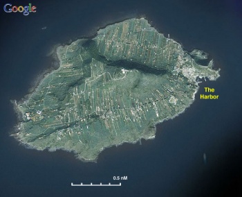
Ustica is a small island, of about 1400 inhabitants, in the Aeolian Island Archipelago and is situated some 60 nM north of Palermo in Sicily. It is a low key and charming island mostly dedicated to underwater tourists who are taken in organized groups to its numerous underwater grottos.
Ustica has been populated since about 1500 BC by τηε Phoenicians. In ancient Greece, the Island was named Osteodes (Οστεώδης - ossuary) in memory of the thousands of Carthaginian mutineers left there to die of hunger in the 4th century BC. The Romans renamed the island Ustica, Latin for burnt, because of its black rocks. More recently during the fascist period, Ustica was used as place for exile for the political opponents of the dictator Mussolini. There is considerable diving activity from Ustica.
Weather
See Italy.
Charts
- BA
- 1976 - Cappo di Bonifati to Capo San Víto
- NIMA
- 53180 - Napoli to Palermo including Isole Eolie
- 53181 - Plans in the Tyrrhenian Sea
- 52180 - Strait of Sicily-Northern Reaches
Radio Nets
Also see World Cruiser's Nets.
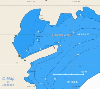
The approaches to Ustica are straightforward without any dangers. The harbour at Cala Santa Maria is at the easternmost extremity of the island.
Berthing Options
Ports
| Cala Santa Maria
| |
There is only one anchorage, the small main harbour of Cala Santa Maria. During the season, it is invariably filled to capacity. Since there are no alternative anchorages, Ustica should only be visited in settled weather.
It is supposed to be crowded during the summer but during my two visits, both in October, I had room enough to moor side-to. --Istioploos ![]() 14:22, 14 July 2008 (MDT)
14:22, 14 July 2008 (MDT)
We visited by ferry from Palermo in May and were glad we had left Athene in Palermo, since there was no space in the harbour. While we were there, a French yacht arrived and promptly sailed off again. --Athene of Lymington 17:30, 10 November 2010 (UTC)
Marinas & Yacht Clubs
None.
Anchorages
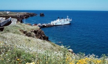
Just to the south of the ferry dock - which is actually outside the harbour breakwater - an anchorage can be found in 20m half a cable off the cliffs in the vicinity of Grotto Azzura. It is by no means an ideal anchorage but in typical settled summer weather it is doable. We were there the day after a three day mistral had gone through and even with a large NNW swell the mistral had produced there was sufficient protection tucked in behind here behind the land. In any case if you are arriving from the east having cruised the rest of the Aeolian islands you will not be too perturbed by the lack of all round shelter or depth and steepness of the ground in which you attempt to anchor, as these conditions will have come to seem normal by now.--SUZIECREAMCHEESE
Offshore Islands
None.
Yacht Services and Repairs
N/A (Not Available)
Marine Stores
None.
Repairs/Yards
None.
Fuel, Water, & Electricity
- Fuel
- There is a fuel station at the SE entrance of the harbor. There is very tight maneuvering room. The station is attended every day from 0700 to 1900
- Water
- Near the fuel station
- Electricity
- N/A
Things to do Ashore
Tourism
The village, up the hill, is small and picturesque. It is a delight to wander in its narrow streets. Several of the houses have colourful murals painted on their outside walls. Taking nice long hikes in the island is also great fun. NE of the harbour, past the ferry terminal, are the remains of a Bronze Age village at Faraglioni.
Grocery & Supply Stores
- Some limited shopping in the village, about 10 minutes on foot up the hill from the harbour.
- There is a good bakery in the village.
- Camping Gaz is not available.
Eateries
- Good restaurants in the village.
Internet/WiFi
None.
Laundry
None.
Motorbike & Car Rentals
There is one agency in the village.
Transportation
There are twice daily ferries from and to Palermo on the mainland (fast ferry Ustica-Palermo 1 hr 15 mins; slow ferry Palermo-Ustica 2 hrs 20 mins).
Routes/Passages To/From
See Aegean to West Mediterranean Passages.
Cruiser's Friends
Contact details of "Cruiser's Friends" that can be contacted for local information or assistance.
Forum Discussions
List links to discussion threads on partnering forums. (see link for requirements)
External Links
References & Publications
See Italy.
Last Visited & Details Checked (and updated here)
Date of member's visit to this Port/Stop & this page's details validated:
- May 2004 --Athene of Lymington 17:30, 10 November 2010 (UTC)
- October 2004 --Istioploos

 Travels with S/Y Thetis 14:22, 14 July 2008 (MDT)
| This is a usable page of the cruising guide. However, please contribute if you can to help it grow further. Click on Comments to add your personal notes on this page or to discuss its contents. Alternatively, if you feel confident to edit the page, click on the edit tab at the top and enter your changes directly. |
| |
|---|
|
Names: Lighthouse, Istioploos, Athene of Lymington |
| Cruising Wiki Navigation
|
|---|
| | HOMEPAGE | Wiki Contents | Mediterranean | Italy | Sicily | Ustica | |


