User:Vadim/Sandbox2

From CruisersWiki

Jump to: navigation, search

Contents

Amenities

Facilities
Water
Electricity
  • Limited access at the town quay
  • In the marinas
Toilets In the marinas
Showers In the marinas
Laundry In Mandalina Marina
Garbage Bins behind the waterfront and in the marinas
Supplies
Fuel fuel station in Zaglav in two miles NW of Sali
Bottled gas
Chandlers
Services
Repairs Limited emergency repairs only.
Money The only ATM on the island is next to the Tommy supermarket. Alternatively, money can be exchanged at the post office.
Mobile
connectivity
Vehicle
rentals
Rental outlets in the town

Amenities 2

Facilities
Water
Electricity
  • Limited access at the town quay
  • In the marinas
Toilets In the marinas
Showers In the marinas
Laundry In Mandalina Marina
Garbage Bins behind the waterfront and in the marinas
Supplies
Fuel fuel station in Zaglav in two miles NW of Sali
Bottled gas
Chandlers
Services
Repairs Limited emergency repairs only.
Money The only ATM on the island is next to the Tommy supermarket. Alternatively, money can be exchanged at the post office.
Mobile
connectivity
Vehicle
rentals
Rental outlets in the town

list table

Water
Electricity
  • Limited access at the town quay
  • In the marinas
Toilets In the marinas
Showers In the marinas
Laundry In Mandalina Marina
Garbage Bins behind the waterfront and in the marinas

poi test

Porto quadro

Porto quadro/wiki/User:Vadim/Sandbox2#Porto_quadro
Harbour icon Porto quadro [[User:Vadim/Sandbox2#Porto quadro|Porto quadro]] 41°14.925′N, 9°12.707′E
A smaller bay, closer to Santa Teresa Gallura, but unsuitable with W - NW winds. There is an ugly hotel complex on the shore.


Porto quadro 2

Porto quadro 2/wiki/User:Vadim/Sandbox2#Porto_quadro_2
Anchorage icon Porto quadro 2 [[User:Vadim/Sandbox2#Porto quadro 2|Porto quadro 2]] 41°14.925'N, 009°12.707'E
A smaller bay, closer to Santa Teresa Gallura, but unsuitable with W - NW winds. There is an ugly hotel complex on the shore.

tables

Key to symbols: |
Island icon – island |Port of entry icon – port of entry |Harbour icon – harbour |Marina icon – marina |Anchorage icon – anchorage |Waterway or canal icon – waterway or canal |Needs data icon – needs data |
|
North Aegean NE Aegean North Dodecanese South Dodecanese
Kavala Port of entry icon – port of entry |Harbour icon – harbour |
Porto Lago Harbour icon – harbour |
Maronia Harbour icon – harbour |
Alexandroupolis Port of entry icon – port of entry |Harbour icon – harbour |Marina icon – marina |
Thasos Island icon – island |Harbour icon – harbour |Anchorage icon – anchorage |
Samothrace Island icon – island |Harbour icon – harbour |
Limnos Island icon – island |Port of entry icon – port of entry |Harbour icon – harbour |Anchorage icon – anchorage |
Ayios Efstratios Island icon – island |Harbour icon – harbour |
Lesvos Island icon – island |Port of entry icon – port of entry |Harbour icon – harbour |Marina icon – marina |Anchorage icon – anchorage |
Psara Island icon – island |Harbour icon – harbour |Anchorage icon – anchorage |
Oinousses Island icon – island |Harbour icon – harbour |Anchorage icon – anchorage |
Chios Island icon – island |Port of entry icon – port of entry |Harbour icon – harbour |Marina icon – marina |Anchorage icon – anchorage |
Ikaria Island icon – island |Harbour icon – harbour |Anchorage icon – anchorage |
Fourni Island icon – island |Harbour icon – harbour |Anchorage icon – anchorage |
Agathonisi Island icon – island |Harbour icon – harbour |Anchorage icon – anchorage |
Patmos Island icon – island |Port of entry icon – port of entry |Harbour icon – harbour |Anchorage icon – anchorage |
Arki and Marathi Island icon – island |Harbour icon – harbour |Anchorage icon – anchorage |
Lipsi Island icon – island |Harbour icon – harbour |Anchorage icon – anchorage |
Leros Island icon – island |Harbour icon – harbour |Marina icon – marina |Anchorage icon – anchorage |
Kalymnos Island icon – island |Harbour icon – harbour |Anchorage icon – anchorage |
Pharmakonisi Island icon – island |Anchorage icon – anchorage |
Pserimos Island icon – island |Anchorage icon – anchorage |
Levitha and Kinaros Island icon – island |Anchorage icon – anchorage |
Kos Island icon – island |Port of entry icon – port of entry |Harbour icon – harbour |Marina icon – marina |Anchorage icon – anchorage |
Niseros and Yiali Island icon – island |Harbour icon – harbour |Marina icon – marina |Anchorage icon – anchorage |
Astypalea Island icon – island |Harbour icon – harbour |Anchorage icon – anchorage |
Syrna Island icon – island |Anchorage icon – anchorage |
Tilos Island icon – island |Harbour icon – harbour |Marina icon – marina |Anchorage icon – anchorage |
Sými Island icon – island |Port of entry icon – port of entry |Harbour icon – harbour |Anchorage icon – anchorage |
Chálki Island icon – island |Anchorage icon – anchorage |
Alimniá Island icon – island |Anchorage icon – anchorage |
Rhodes Island icon – island |Port of entry icon – port of entry |Harbour icon – harbour |Anchorage icon – anchorage |
Kasos Island icon – island |Harbour icon – harbour |
Karpathos Island icon – island |Harbour icon – harbour |Anchorage icon – anchorage |
Kastelorizo Island icon – island |Port of entry icon – port of entry |Harbour icon – harbour |Anchorage icon – anchorage |

etc

Vadim/Sandbox2
41.2487541°14.74′N, 9.211783333333309°11.93′E Chart icon.png
SantaTeresa.jpg
Magnify-clip.png
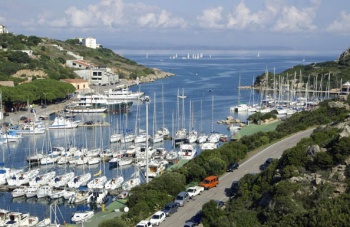
The port of Santa Teresa

{{urlencode:test space|PATH}} test+space

{{anchorencode:test space}} test_space

{{localurl:test space}} /wiki/Test_space

#jump-to-nav + h2,
script + h2
{
    display: none;
}
Personal tools
advertisement
Friends of Cruisers Wiki