Caribbean
From CruisersWiki
Lighthouse (Talk | contribs) (Minor Edit) |
Lighthouse (Talk | contribs) (Minor Edit) |
||
| Line 21: | Line 21: | ||
{| class="wikitable" | {| class="wikitable" | ||
|- | |- | ||
| - | | [[Bermuda|Bermuda]] (Has data)<br/>[[Bahamas|Bahamas]] (Has data)<br/>[[Abacos|Abacos]] (Has data)<br/>[[Exumas|Exumas]] (Has data)<br/>[[Cuba|Cuba]]<br/>[[Turks_Caicos|Turks & Caicos]]<br/>[[Spanish_Virgins|Spanish Virgin Islands]] (Has data)<br/>[[UK_Virgins|British Virgin Islands (BVI's)]] (Has data)<br/>[[Haiti|Haiti]]<br/>[[Dominican_ Republic|Dominican Republic]] (Has data)<br/>[[Puerto_Rico|Puerto Rico (US)]] (Has data)<br/>[[US_Virgins|US Virgin Islands]] (Has data)<br/>[[Antigua|Antigua & Barbuda]] (Has data)<br/> | + | | *[[Bermuda|Bermuda]] (Has data)<br/>*[[Bahamas|Bahamas]] (Has data)<br/>*[[Abacos|Abacos]] (Has data)<br/>*[[Exumas|Exumas]] (Has data)<br/>*[[Cuba|Cuba]]<br/>*[[Turks_Caicos|Turks & Caicos]]<br/>*[[Spanish_Virgins|Spanish Virgin Islands]] (Has data)<br/>*[[UK_Virgins|British Virgin Islands (BVI's)]] (Has data)<br/>*[[Haiti|Haiti]]<br/>*[[Dominican_ Republic|Dominican Republic]] (Has data)<br/>*[[Puerto_Rico|Puerto Rico (US)]] (Has data)<br/>*[[US_Virgins|US Virgin Islands]] (Has data)<br/>*[[Antigua|Antigua & Barbuda]] (Has data)<br/> |
|| [[St_Martin|St Martin (Fr)]] (Has data)<br/>[[Sint Maarten|Sint Maarten (Neth)]] (Has data)<br/>[[St Barts]] (Has data)<br/>[[Montserrat|Montserrat]] (Has data)<br/>[[StKitts_Nevis|St Kitts & Nevis]] (Has data)<br/>[[Guadaloupe|Guadeloupe]] (Has data)<br/>[[Dominica|Dominica]] (Has data)<br/> [[Martinique|Martinique]] (Has data)<br/>[[St_Lucia|St Lucia]] (Has data)<br/>[[St_Vincent|St Vincent & The Grenadines]] (Has data)<br/>[[Barbados|Barbados]] (Has data)<br/>[[Grenada|Grenada]] (Has data)<br/> | || [[St_Martin|St Martin (Fr)]] (Has data)<br/>[[Sint Maarten|Sint Maarten (Neth)]] (Has data)<br/>[[St Barts]] (Has data)<br/>[[Montserrat|Montserrat]] (Has data)<br/>[[StKitts_Nevis|St Kitts & Nevis]] (Has data)<br/>[[Guadaloupe|Guadeloupe]] (Has data)<br/>[[Dominica|Dominica]] (Has data)<br/> [[Martinique|Martinique]] (Has data)<br/>[[St_Lucia|St Lucia]] (Has data)<br/>[[St_Vincent|St Vincent & The Grenadines]] (Has data)<br/>[[Barbados|Barbados]] (Has data)<br/>[[Grenada|Grenada]] (Has data)<br/> | ||
| - | || [[Trinidad_Tobago|Trinidad & Tobago]] (Has data)<br/>[[neth_Antilles|Netherlands Antilles)]]<br/> | + | || [[Trinidad_Tobago|Trinidad & Tobago]] (Has data)<br/>[[neth_Antilles|Netherlands Antilles)]]<br/>** [[Sint Maarten|Sint Maarten (Neth)]]<br/>** [[Bonaire|Bonaire (Neth)]]<br/>** [[Curacao|Curacao (Neth)]]<br/>[[Aruba|Aruba (Neth)]]<br/>[[Jamaica|Jamaica]] (Has data)<br/>[[Cayman|Cayman Isles]]<br/>[[San Andres|San Andres (Colombia)]]<br/>[[San Blas Islands|San Blas Islands (Panama)]]<br/>[[Guanaya]] (see [[Honduras]])<br/>[[Roatan]] (see [[Honduras]])<br/>[[Utilla]] (see [[Honduras]])<br/> |
|} | |} | ||
Revision as of 17:53, 6 October 2009
Contents |
THE CARIBBEAN CRUISING GUIDE
An online cruising guide for yachts sailing around the islands in the Caribbean.

Background
The whole Caribbean region is one of the most popular cruising and sailing regions in the world.
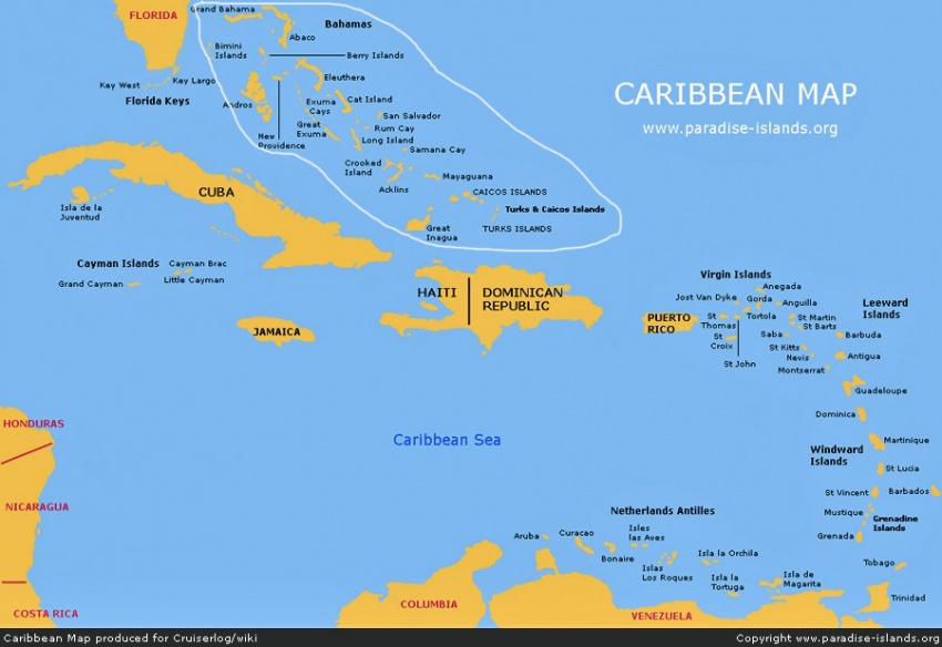
The Caribbean (Dutch: Cariben or Caraïben; French: Caraïbe or more commonly Antilles; Spanish: Caribe) is a region of the Americas consisting of the Caribbean Sea, its islands (most of which enclose the sea), and the surrounding coasts. The region is located southeast of North America, east of Central America, and to the north of South America.
Situated largely on the Caribbean Plate, the region comprises more than 7,000 islands, islets, reefs, and cays. Also called the West Indies, since Christopher Columbus landed here in 1492 believing he was in India, the region consists of the Antilles, divided into the larger Greater Antilles which bound the sea on the north and the Lesser Antilles on the south and east (including the Leeward Antilles), and the Bahamas. Geopolitically, the West Indies are usually reckoned as a subregion of North America and are organised into 27 territories including sovereign states, overseas departments, and dependencies. At one time, there was a short-lived country called the Federation of the West Indies composed of ten English-speaking Caribbean territories.
The Caribbean islands are an island chain 4,020 kilometres (2,500 mi) long and no more than 257 kilometres (160 mi) wide at any given point. They enclose the Caribbean Sea.
The region takes its name from that of the Carib, an ethnic group present in the Lesser Antilles and parts of adjacent South America at the time of European contact. In the English-speaking Caribbean, someone from the Caribbean is usually referred to as a "West Indian," although the phrase "Caribbean person" is sometimes used.
General Cruising/Sailing in the Caribbean
Expand about cruising/sailing in the region?
The Caribbean Islands/Groups
| *Bermuda (Has data) *Bahamas (Has data) *Abacos (Has data) *Exumas (Has data) *Cuba *Turks & Caicos *Spanish Virgin Islands (Has data) *British Virgin Islands (BVI's) (Has data) *Haiti *Dominican Republic (Has data) *Puerto Rico (US) (Has data) *US Virgin Islands (Has data) *Antigua & Barbuda (Has data) | St Martin (Fr) (Has data) Sint Maarten (Neth) (Has data) St Barts (Has data) Montserrat (Has data) St Kitts & Nevis (Has data) Guadeloupe (Has data) Dominica (Has data) Martinique (Has data) St Lucia (Has data) St Vincent & The Grenadines (Has data) Barbados (Has data) Grenada (Has data) | Trinidad & Tobago (Has data) Netherlands Antilles) ** Sint Maarten (Neth) ** Bonaire (Neth) ** Curacao (Neth) Aruba (Neth) Jamaica (Has data) Cayman Isles San Andres (Colombia) San Blas Islands (Panama) Guanaya (see Honduras) Roatan (see Honduras) Utilla (see Honduras) |
Caribbean Climate and Weather
The climate of the region is tropical but rainfall varies with elevation, size and water currents (cool upwellings keep the ABC islands arid). Warm, moist tradewinds blow consistently from the east creating rainforest/semidesert divisions on mountainous islands. Occasional northwesterlies affect the northern islands in the winter. Winters are warm, but drier.
The waters of the Caribbean Sea host large, migratory schools of fish, turtles, and coral reef formations. The Puerto Rico trench, located on the fringe of the Atlantic Ocean and Caribbean Sea just to the north of the island of Puerto Rico, is the deepest point in all of the Atlantic Ocean.
Hurricanes, which at times batter the region, usually strike northwards of Grenada, and to the west of Barbados. The principal hurricane belt arcs to northwest of the island of Barbados in the Eastern Caribbean.
Sources of weather forecasting information:
Radio Nets
Also see World Cruiser's Nets
- HF Nets:
- VHF Nets:
- St. Martin/Maarten 0730 VHF 14 Monday-Saturday
- English Harbour 0900 VHF 68/06 Daily
- Grenada 0730 VHF 68 Monday-Saturday
- Chaguaramas 0800 VHF 68 Monday-Sunday
- Porlamar 0800 VHF 72 Monday-Saturday
- Puerto La Cruz 0745 VHF 72 Monday-Saturday
Popular Caribbean Cruising Circuits
Also see Gulf Stream Crossing
References
Books, Guides, etc.
Forum Discussions
Links to discussions on the CruiserLog Forum
External Links
Links to relative websites
Personal Notes
| |
|---|
| | HOMEPAGE | Wiki Contents | Caribbean | |
.
