East Peloponnese
From CruisersWiki
Istioploos (Talk | contribs) m (Changed protection level for "East Peloponnese" ([edit=autoconfirmed] (indefinite) [move=autoconfirmed] (indefinite))) |
m (Text replace - "==References & Publications==" to "==References==") |
||
| (6 intermediate revisions not shown) | |||
| Line 1: | Line 1: | ||
{{IsPartOf|Mediterranean|Greece|Aegean Sea}} | {{IsPartOf|Mediterranean|Greece|Aegean Sea}} | ||
{{TOC block}} | {{TOC block}} | ||
| - | + | {{Page imagemap}} | |
| - | + | ||
| - | + | ||
| - | + | ||
| - | + | ||
| - | + | ||
| - | + | ||
| - | + | ||
| - | + | ||
| - | + | ||
| - | + | ||
| - | + | ||
| - | + | ||
| - | + | ||
| - | + | ||
| - | + | ||
| - | + | ||
| - | + | ||
South Peloponnese or Gulf of Argolis is very popular because of its proximity to Athens and because the summer ''meletemi'' winds are milder here than in the [[Cyclades]]. The coast of east Peloponnese is beautiful and dramatic. However, there are only a few anchorages. | South Peloponnese or Gulf of Argolis is very popular because of its proximity to Athens and because the summer ''meletemi'' winds are milder here than in the [[Cyclades]]. The coast of east Peloponnese is beautiful and dramatic. However, there are only a few anchorages. | ||
| - | == | + | ==Charts== |
; BA | ; BA | ||
: 1031 Yerakas to Kea | : 1031 Yerakas to Kea | ||
| Line 34: | Line 17: | ||
: 415 Ydra to Sikinos | : 415 Ydra to Sikinos | ||
| - | ==Weather | + | ==Weather== |
The winds here during the May - October period tend to be from the NE seldom exceeding force 4. During the November -April period they are from the SE often at gale force. But, because of the high mountains, there can be ferocious gusts especially near Maleas. | The winds here during the May - October period tend to be from the NE seldom exceeding force 4. During the November -April period they are from the SE often at gale force. But, because of the high mountains, there can be ferocious gusts especially near Maleas. | ||
''See also [[Aegean_Sea#Weather|Aegean Sea]]''. | ''See also [[Aegean_Sea#Weather|Aegean Sea]]''. | ||
| - | ==Currents & Tides== | + | ====Currents & Tides==== |
Both currents and tides are very weak, | Both currents and tides are very weak, | ||
| - | == | + | ==Passages== |
| - | + | * [[Circumnavigating the Peloponnese]] | |
| + | * | ||
| - | == | + | ==Communication== |
* Coast Guard - VHF channel 12 | * Coast Guard - VHF channel 12 | ||
* Olympia Radio - VHF channels 27, 83, 84, or 86 | * Olympia Radio - VHF channels 27, 83, 84, or 86 | ||
| Line 51: | Line 35: | ||
''Also see [[World MM Nets|World Cruiser's Nets]]''. | ''Also see [[World MM Nets|World Cruiser's Nets]]''. | ||
| - | == | + | ==Navigation== |
| + | Approaches in general are straightforward. Details are given for each port. | ||
| + | |||
| + | ==Berthing== | ||
| + | |||
| + | {{Dest legend|h|e|a|m|i}} | ||
| + | |||
From N to S. | From N to S. | ||
| Line 75: | Line 65: | ||
|} | |} | ||
| - | + | ==Friends== | |
| - | + | ||
| - | == | + | |
| - | + | ||
| - | + | ||
| - | + | ||
| - | + | ||
Contact details of "Cruiser's Friends" that can be contacted for local information or assistance. | Contact details of "Cruiser's Friends" that can be contacted for local information or assistance. | ||
* | * | ||
| - | == | + | ==Forums== |
List links to discussion threads on [[Cruising Forums|partnering forums]]. (''see link for requirements'') | List links to discussion threads on [[Cruising Forums|partnering forums]]. (''see link for requirements'') | ||
* | * | ||
| - | == | + | ==Links== |
| - | * | + | * {{wikipedia|Peloponnese|Peloponnese}} |
| - | * | + | * {{Wikivoyage|Peloponnese|Peloponnese}} |
| - | * | + | * {{wikipedia|Argolic_Gulf|Gulf of Argolis}} |
| + | * {{wikipedia|Nafplio|Nafplio}} | ||
| - | ==References | + | ==References== |
''See [[Greece#References_&_Publications|Greece]]''. | ''See [[Greece#References_&_Publications|Greece]]''. | ||
{{Comments}} | {{Comments}} | ||
| - | |||
* | * | ||
| Line 108: | Line 92: | ||
| - | [[Category:Regions | + | [[Category:Regions - Greece]] |
Latest revision as of 11:48, 15 August 2018
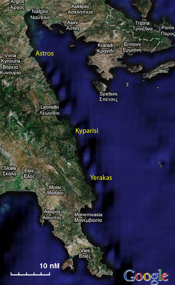

South Peloponnese or Gulf of Argolis is very popular because of its proximity to Athens and because the summer meletemi winds are milder here than in the Cyclades. The coast of east Peloponnese is beautiful and dramatic. However, there are only a few anchorages.
Charts
- BA
- 1031 Yerakas to Kea
- Imray-Tetra
- G14 Saronic and Argolic Gulfs
- G15 Southern Peloponnisos
- NIMA
- 54340 Nisos Spetsai - N. Vorioi Sporadhes
- Greek
- 414 Poros mechri Monemvasia
- 415 Ydra to Sikinos
Weather
The winds here during the May - October period tend to be from the NE seldom exceeding force 4. During the November -April period they are from the SE often at gale force. But, because of the high mountains, there can be ferocious gusts especially near Maleas.
See also Aegean Sea.
Currents & Tides
Both currents and tides are very weak,
Passages
Communication
- Coast Guard - VHF channel 12
- Olympia Radio - VHF channels 27, 83, 84, or 86
Also see World Cruiser's Nets.
Approaches in general are straightforward. Details are given for each port.
Berthing
From N to S.
|
Astros |
Leonidio |
|
Friends
Contact details of "Cruiser's Friends" that can be contacted for local information or assistance.
Forums
List links to discussion threads on partnering forums. (see link for requirements)
Links
- Peloponnese at the Wikipedia
- Peloponnese at the Wikivoyage
- Gulf of Argolis at the Wikipedia
- Nafplio at the Wikipedia
References
See Greece.
Comments
We welcome users' contributions to the Wiki. Please click on Comments to view other users' comments, add your own personal experiences or recommend any changes to this page following your visit.
| This is a usable page of the cruising guide. However, please contribute if you can to help it grow further. Click on Comments to add your personal notes on this page or to discuss its contents. Alternatively, if you feel confident to edit the page, click on the edit tab at the top and enter your changes directly. |
| |
|---|
|
Names: Istioploos |